
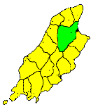
THE parish of LEZAYRE (the garden of the Island) extends from Michael and Ballaugh on the west, to the sea; and the mountains of Lonan and Maughold on the east; and from Andreas and Bride on the north, to Braddan on the south. Its extreme dimensions are seven miles long from north to south, by five miles broad from east to west, and its area is about 22 square miles. This extensive parish consists of two very dissimilar portions—a low, flat district in the north, the southern part of the Curragh; and a high mountain region in the south, which includes the whole of the central range, from Pen-y-Phot to North Barrule. The northern portion is flat and uninteresting, but fertile and well cultivated. In it, and in the adjoining parts of the neighbouring parishes of Andreas and Bride, were formerly several large lakes, which are now drained and their sites reclaimed. One, called Lough Malor, and marked in Speed's map, was a mile in length, and fell into the Sulby river, near Kella. Another, nearly as large, was drained into the sea by the Lhen Mooar. The waters of these lakes were carried off by a deep drain (called the Lhen Mooar Trench), made about the end of the 17th century, and their sites now form part of The Curragh. In working these reclaimed lands, large numbers of fossil trees have been dug up, together with numerous relics of the fossil elk (Megaceros Hibernicus), the first complete specimen of which was found in this district. The southern part of the parish is high and mountainous, penetrating into the heart of the central mountain mass, and including the highest points in the range- Snaefell 2,034 feet, North Barrule 1,842 feet, Clagh Ouyre 1,808 feet, Pen-y-Phot 1,772 feet, Slieau Menagh 1,2l7 feet, and Mount Karrin 1,064 feet. The chief glens of the district are Glen Mooar, or Sulby Glen, and Glen Auldyn, both mountain glens of great beauty and the principal river is the Sulby, which, rising on Snaefell, flows down Glen Mooar and emerging on to the Northern Plain at the village of Sulby, skirts the northern base of the mountains. After receiving the Glen Auldyn stream it runs into the sea at Ramsey. The parish is exclusively agricultural, and, with the exception of the village of Sulby, at the mouth of Glen Mooar, and the northern suburb of Ramsey, which has greatly increased of late years, the population is sparsely scattered over its surface.
Brown's Isle of Man Directory, 1894
|
|
||
|
© F.Coakley, 2006 |
||