Speed's MapSpeed's Map
|
240 x 380 mm |
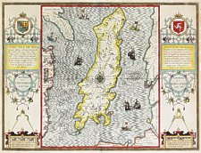
The first map of the Island alone, and the first based on actual survey, was that of Thomas Durham of 1595 first published by Speed in 1605/1611 and reprinted many times over the next century. The map is based on a survey (and presumably a MS map) by Thomas Durham, of whom nothing is known other that he was paid by Sir Thomas Gerrard to make a survey of the Island. This survey, almost certainly for military purposes, arose from the disputed possession of the Island during which time Elizabeth had assumed control in order to prevent the Scots or the Spanish from using the Island as a base. |
A larger scale (non-coloured) is available (image(70k) (or ~1MByte on the CD-ROM) which shows more details.
Speed had used the Durham Map in his slightly earlier 4-sheet wall map showing invasions and battles of c1603/4 [ref: Shirley #261] - there are some differences from 1605/10 map - Port Eran (rather than Earn on 1605);Knockalo point (= Contrary Hd) not on 1605;Spalbrecke shown west of Calf rather than E as on 1605/10. Thus it is possible that the Durham Map had even more detail than Speed used in his derived version.
A very limited set of 'proof' state maps bearing date 1605 (instead of 1610) exist - these have no stippling in the sea.
In sea are four mythical beasts with riders: to NW of Island Unicorn with Scottish flag, to NE Lion with English flag; N Irish Whale with Irish flag; to S dragon? with French? flag;
In Irish sea to E of Island two ships are fighting; all these were descriptive of strained relationship between England and Scotland prior to accession of James.
The map shown above first appeared in a collection of 67 maps prepared by John Speed derived from the surveys of John Norden and Christopher Saxton excepting the Isle of Wight by William White and Isle of Man by Thomas Durham.
The biography of John Speed and the history of this important undertaking, the ‘best known and most popular of English county maps’ are well covered elsewhere, see for example Skelton.
Shilder + Wallis Speed Military Maps discovered The Map Collector #48 Autumn 1989
The plate was in use for nearly a century and a half - no change was made to the Island details but changes were made to the righthand side panel with an additional imprint made near the compass arms. In the last state the years 1595 and 1610 were erased.
rh scroll text dated 1605 - no sea stippling
rh scroll text dated 1610
The Theatre of the Empire of Great Britaine:presenting an exact geography of the Kingdomes of England, Scotland, Ireland, and the Isles adioying:with the Shires, Hundreds, Cities and Shire-towns, within ye Kingdome of England, divided and described by John Speed. Imprinted at London. Anno, cum Privilego, 1611[-1612]
London: And to be solde by John Sudbury and Georg Humble, in Popes-head alley at ye signe of ye White Horse
The Theatre …
London John Sudbury and George Humble 1614 (1616) {BL Maps C 7 c 19}
Latin Text on reverse
Theatrum Imperii Magnae Britanniae…
London John Sudbury and George Humble 1616) {BL Maps C 7 c 20}
The Theatre …
London John Sudbury and George Humble 1614 (re-issued 1623)
The Theatre …
London: George Humble 1627 {BL Maps C 7e13}
The Theatre …
London: George Humble 1627 (issued 1632) {BL Maps C 7c 6}
The Theatre …
London: George Humble 1627 (issued after 1631
issued with
A Prospect of the most Famous Parts of the World
London: George Humble 1631
The Theatre …
London: George Humble 1627 (issued1646),1650(re-issued 1651/2/3/4)
issued with
A Prospect of the most Famous Parts of the World
London: William Humble 1646
However as complete copies of these Atlases are unlikely to be afforded by the average collector it is possible to date individual maps by the text on back of the map.
1611 English text Chap 47 Pages 91&92 Register Aal End 1st Line "... is termed" End 1st column '...and so'
1614/16 English text Chap 46 Pages 91&92 Register ddd End 1st Line "... is termed" End 1st column '...and so'
1616 Latin text Chap 46 Pages 91&92 Register Aal End 1st Line "... iPtolemasc" End 1st column '...Namque'
1627 English text Chap 46 Pages 91&92 Register Aal End 1st Line "... is termed" End 1st column '...and so' [pub George Humble]
1631 English text Chap 46 Pages 91&92 Register Aal End 1st Line "... is termed" End 1st colunm '...vpon' [pub George Humble] {pxx.3.M}
1646 English text Chap 46 Pages 91&92 Register Aal End 1st Line "... is termed by PTO" End 1st column '...plaintiffe, by' [pub George Humble]
Imprint altered to “Performed … Are to be solde by Roger Rea the Elder, and younger, at the Golden Crosse in Cornhill against ye Exchange”
The Theatre …
London: Roger Rea the Elder and Younger 1650 (?1665)
issued with
A Prospect of the most Famous Parts of the World
London: Roger Rea the Elder and Younger 1662 {BL (118 e 8)}
Imprint altered to “Performed… Are to be sold by Tho: Basset in Fleetstreet, and Ric: Chiswell in St. Pauls Churchyard”.
The Theatre …By John Speed. With many Additions never before
Extant
London: Thomas Basset and Richard Chiswell. 1676 {BL Maps C 7 e
5}
without text - on thin laid paper prob sold as separate map:
“At the Shops of the said Thomas Basset and Richard Chiswell, the Particular Mape of …any shire and County in the Kingdoms of Great Britain and Ireland, will be sold by themselves, without the Description, to such as desire them. Price each map 6d” quoted from a Term Catalogue of 10 Feb 1676 by Whitaker
without text but on thick laid paper
No 56 from
A Set of Mape of the several Counties of England and Wales…Printed and sold by Henry Overton, at the White Horse without Newgate
Imprint altered to “Printed and Sold by Henry Overton at the White Horse without Newgate London”
without text on reverse
England Fully Described in a Compleat Sett of Mapps of ye County’s of England and Wales, with their islands, Cotaining in all Fifty Eight Mapps.
London H.Overton 1713
dates 1595 and 1610 erased from plates;
Imprint “Printed and Sold by Henry Overton at ye White Horse without Newgate London”
without text on reverse
England Fully Described…
London H.Overton post 1716,c1720; 1743
A Sett of the Counties of England and Wales, with their Islands, containing Fifty Eight Maps; each on a Sheet of Royal Paper. By John Speed. Reprinted in the Year 1743. With Additions. Sold either in Compleat Setts,…Coloured. Price £1.4s
Other maps (53 from 57) have imprint altered to Diceys imprint but not IoM
The English Atlas…(ms title page)
London: C.Dicey (1770)
|
|
||
|
|
||
|
Any comments, errors or omissions
gratefully received The
Editor |
||