
The political history of the Island, Celtic followed by Scandinavian, Scottish and finally English control is still visible in its land divisions.
After the battle of Sky Hill in 1079 the Chronicle states that
Godred then granted to the few islanders who had remained with him, the southern part of the island, and to the surviving Manxmen the northern portion...
The islanders probably referred to inhabitants of the Hebrides whereas the grant of the North probably implied a movement of chiefs rather than whole populations.
By the early 16th century the Island was divided into two divisions running North and South of the Mountain range (rather than N/S of the Douglas/Peel valley). As Sacherverell[1702] states the whole Island is divided into the North and South, each of which has its Castle, Deemster or Judge, and Vicar-General; each Sheading, or Subdivision, its Coroner; every Parish, its Captain and Minister; and every Fort its Constable.
Dolley [1976] puts it thus:
A feature of Man ever since what an Anglophone Manxman would term 'King Orry's day' has been a feeling of difference between the two sides of the central diagonal watershed to which reference has already been made. In place-name studies it has been recognized most recently by Dr Margaret Gelling in comments such as 'the Gaelic language gained ground most quickly in the north', the reference here, of course, being to the replacement of Old Norse by Manx in such areas as may have been purely Scandinavian-speaking for perhaps as much as two centuries. Evidence of this national dichotomy at a relatively early date is likewise provided by the dedications of the Island's seventeen parish churches. On the 'south side' eight out of nine are under the protection of Irish saints of whom only Brendan at Bradden can be said to be internationally known. In marked contrast there are on the 'north side' no more than four out of eight Irish dedications, while three of these (those for Kirk Patrick, Jurby and Bride) involve the names of the two patrons of Ireland, Patrick the Apostle, and Brigid of Kildare. Traditionally, too, the people on the two sides of the island have been differentiated by custom and by temperament...
| North Side | South Side | 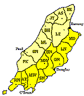 |
||
|---|---|---|---|---|
| Patrick | PK | Rushen | RN | |
| German | GN | Arbory | AY | |
| Michael | ML | Malew | MW | |
| Ballaugh | BH | Santan | SN | |
| Jurby | JY | Marown | MN | |
| Andreas | AS | Braddan | BN | |
| Bride | BE | Onchan | ON | |
| Lezayre | LE | Lonan | LN | |
| Maughold | MD | |||
Note Onchan was moved to Middle in 1796 when Maughold started to be listed with Northside parishes - however even after
200 years locals still feel that Maughold is not truly part of the Northside.
The Island was (and still is for some purposes) divided into six sheadings, this certainly had happened by 1422 - Kinvig
suggests that this derives from the Middle English scheding 'a division' and was introduced to the island at the
beginning of the 15th century when Sir John Stanley became King of Man though Kneen considers that
there is some evidence of earlier use. An often repeated derivation is from 'Skeid' or Ship Thing - ship-assembly - in which
each Sheading providing oarsman for a warship of which six were required in 1324 by King Robert Bruce in the grant of the
Island to the Earl of Moray. Another, less romantic, explanation is a sixth from the Scandinavian and were introduced
by the Scots to break the Scandinavian mould of government in the 14th Century.
The first map to (partially) indicate sheading boundaries was that by King of 1644.
The sheadings and their contained parishes (pre 1796) are:
| Sheading | Parishes | 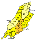 |
||
|---|---|---|---|---|
| Rushen | Rushen | Arbory | Malew | |
| Middle | Santan | Marown | Braddan | |
| Garff | Onchan | Lonan | Maughold | |
| Glenfaba | Patrick | German | ||
| Michael | Michael | Ballaugh | Jurby | |
| Ayre | Lezayre | Andreas | Bride | |
Note Onchan was transferred from Garff to Middle in 1796
Young in his History of the Isle of Man under the Norse argues that a division into quarters would be more consonant with Scandinavian practice elsewhere. This might explain the retention of 24 Members in the Keys even though the eight corresponding to the Soudreys had left, as the need to keep 4 members/division as the number of divisions changed from 4 to 6. It may also explain the original 16 parishes as 4/division
Parishes are divided into Treens (or better a number of treens were gathered into parishes
probably in the 12th Century.). It is thought that this division into treens reflects earlier Celtic land divisions. The
number and sizes of these treens vary across the parishes.
A Treen generally contained four Quarterlands (or farms) and was used as a convenient fiscal division
with the annual tax ("Lord's rent") payable according to its size. Each treen would have is own small chapel or Keeill
. Land which was not considered of great farming value was left as common land - enclosures of such land formed
the intacks.
The divisions into quarterlands is not however consistent and their original use remains obscure. In the old Parish churches
sitting space was generally allocated on the basis of quarterland farms with intack-holders and cottagers relegated to the
galleries.
With the exception of the Marown/Santan boundary parish boundaries followed those of treens; it must be said however, that
these treen boundaries also followed natural divisions such as streams, watersheds etc.
The Island is split into 17 parishes - Kinvig is of the opinion that that they were originally of a military nature but now linked with ecclesiastical and civil matters; originally it was likely that there were 16 parishes, Santan and Marown being one. Marown is the only parish without a coastline, essential before last century for transport etc. and the division between Marown and Santan cuts through a treen rather than, as everywhere else, following the treen boundary. Most parish divisions follow some feature of the land - e.g. Lonan is the basin of the Laxey River, Onchan that of the basin of the Groudle and Malew that of the Silverburn. The need of this division, according to Young, was to give three parishes to each of the newly formed southern sheadings in the 14th Century.
Canon Quine argued that the Parish system was introduced under Scots control c.1275 being introduced to Scotland from England - the Bishopric having been established in 1154..
Parish boundaries were indicated, in a confused manner, on the first printed map of the Island, by John
Speed, in 1605/11 and on most since.
The role of the sheading, parish and farm boundary in forming the basis of the Derby Lords' rent collection preserved the
system from the 1420's. Town parishes were carved out in the 19th century. A small readjustment of parish boundaries took
place in 1978 as a reaction to declining church population and growth of population away from old centres.
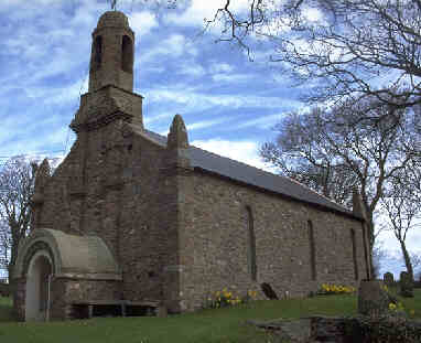
Stenning in his pen picture of the various parishes notes the considerable differences between English villages centered around their parish church and the parishes on the Island. In only five of the parishes is there any sign of a village around the church and none of these, excepting Kirk Michael, follows the English pattern. The parish churches would appear to be on the sites of earlier keeills (or chapels) of which the Island has over 200 many of which are on the sites of pre-Norse chapels. Most of these keeills served a local farming community and are located on farm land. However some sites were more obviously chosen for their spectacular site - the western Celtic tradition of veneration for wells and springs is also apparent.
It should be remembered that the Celtic church in the West originated from missionary contact from the eastern Mediterranean desert Fathers with their ascetic Christianity based on isolation, as opposed to the community based church of the Roman world. St. Patrick was an agent of the Roman church and attempted to counteract these 'wayward' tendencies which however continued in the sixth and seventh centuries. The synod of Whitby, AD 664, ruled in favour of the Roman tradition but the northern Irish (and presumably the Manx) retained their Celtic forms until AD 716. Celtic tradition is obvious in the choice of patronal saints for many of the parishes though signs of a later missionary effort from Scotland are seen in the choice of Scottish saints.
As Betjeman remarks all the old parish churches of the island, despite many rebuildings, have retained the plain, rectangular (length typically 3x breadth) plan of Celtic times.
In the 8th and 9th centuries the island was invaded by Scandinavian pagans who were soon converted. Their major legacy to the church being their cross-slabs which display both pagan legends and Christian themes. The crosses at Kirk Maughold, the Thor Cross at Kirk Bride and the Odin Cross at Kirk Andreas are particularly interesting. Under the Norwegians the western islands of Scotland (Sodor) and the island of Man became a single diocese in around 1153, hence the current name of the diocese 'Sodor and Mann'. Man remained Norwegian until 1266 - its bishop being anointed by the Archbishop of Nidaros (Trondheim) until the detachment of the 'Soudrey's in 1334 when the see was transferred to Canterbury (possibly de facto rather than de jure) and then in 1542 to that of York.
The island being somewhat distant from London saw only slow changes during the Reformation, and its Church remained 'high' church until the beginning of the 19th century (cf. [Radcliffe1895] for a strongly antipopish view). Its bishop having considerable say in the government of the Island and often acting in an autocratic, though usually benign manner.
Apart from a few Quakers who were harshly treated and a few nonconformists and Roman Catholics there was little religious dissent until Wesleyan Methodism arrived on the Island around 1780. This was followed by Primitive Methodism in around 1820. An influx of Irish also around the 1800's revived the Roman Catholic church on the island.
According to Betjeman "Church architecture, as opposed to antiquities, begins with Georgian times. The famous and saintly bishop, Thomas Wilson, who occupied the see from 1698 until his death in 1755, and his successor Bishop Hildesley, were responsible for the restoration and refitting of all old churches. In Bishop Wilson's time there was a Manx baroque style that may be seen in the west front of Ballaugh Old Church. The Gothic Revival came early to the island and may have received its impetus first from the castellated building by George Steuart, built as a house for the Duke of Atholl, the island's owner and governor at the end of the 18th century now known as the Castle Mona Hotel, Douglas.
A Manx Gothic Revival style established itself, and Castletown Church is an early example, while the work of John Welch in the 1820s and '30s is really distinguished
Its churches are many and small. Though none of the earlier ones may have much architectural distinction, they have a storm-resisting, prayer-soaked holiness about them. Most old churches were heavily restored, and only two retain their Georgian fittings"
For many decades the church also served as a parish school - Bishop Wilson strongly disapproved of this practice and attempted, though not always successfully to stop it as it generally resulted in extensive wear on the building fabric. Hinton Bird in his history of Manx Education is quite acerbic about the Manx tendency to put off repairs to buildings until the building is in a ruinous state - typically it seemed to take some 50 years from restoration to 'ruinous' state at which time an unpopular parish precept was arranged to pay for the rebuilding.
Bishop Ward commenced a major building campaign in the 1830's - all but one of his many churches built throughout the island were associated with John Welch (either as Hansom & Welch, Messrs Welch or John Welch) as architect. The author (presumed to be Welch) of A Six Days' Tour , 1836, states Strange to say, this ecclesiastical Hercules, who sows churches and ministers over the country like Deucalion would sow teeth, is scarcely thanked for what he has done. All eight parish churches on the West of the Island were rebuilt in the nineteenth century with only Ballaugh and St. Peters (Peel) left standing. On the East of the Island four were rebuilt in the eighteenth and four in the nineteenth when the ninth, Kirk Maughold, was restored, though the old churches at Lonan, Braddan and Marown were left standing.
With the new holiday traffic of the later part of the 19th century, new churches in North-of-England Victorian style appeared all over the island.
The parishes, in the customary Manx order, are:
St. Trinian's (dedicated to St. Ninian (Scot.)) midway between Douglas and Peel, now a ruin, was the barony church of the baronial lands belonging to the Priory of Whithorn in Galloway.
With the rise in the town population more convenient chapels and later parish churches were established in Douglas , Castletown, Peel and Ramsey.
Other churches are those of the Wesleyan and Primitive Methodists, Congregational and the Roman Catholics.
The classic text on the Diocese of Sodor and Mann is the history by A.W.Moore of 1893, a slightly less full treatment can be found in his 1900 History of the Isle of Man (reprinted 1977 et later).
J. Gelling A History of the Manx Church Douglas:Manx National Heritage 1998
Betjeman, John, Sir (ed.)
Collins guide to English parish churches, including the Isle of Man vol2 North
London:Collins 1958
Kinvig R.H. (Robert Henry)
The Isle of Man: A Social, Cultural and Political History
Liverpool: University Press 1975 0-85323-391-8
xvii,198p ill fcsims maps ports 24cm
Kneen J.J.
The Place-Names of the Isle of Man
printed by Moxton Press for Yn Cheshaght Ghailckagh (The Manx Society). Republished 1970
The Place-Names of the Isle of Man with their origin and history
Douglas: Yn Cheshaght Ghailckagh (The Manx Society) 1925-
Stenning, E.H. (revised J.Grimson)
Portrait of the Isle of Man
London: Hale 1975 3rd 0-7091-5190-X
192p ill map plans 23cm
W.T.Radcliffe,
Ellan Vannin London: Charles H.Kelly 1895 (esp Chap 12)
W. Cubbon,
Island Heritage Manchester: George Falkner & Son 1952
Chap 4 has a description of Treens
M. Dolley,
Some Irish Dimensions to Manx History Belfast:University New Lecture Series No. 92, 1976 (ISBN 0-85389-109-5)
|
|
||
|
|
||
|
|
||
|
Any comments, errors or omissions gratefully received The
Editor |
||