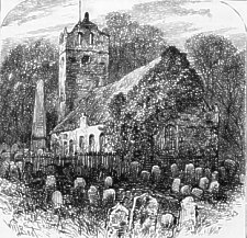
KIRK BRADDAN OLD CHURCH.
KIRK BRADDAN OLD CHURCH.
"Sweet centre of the British isles,
spot where nature, winsome, smiles."
BEAUTIFUL Mona, whose praise the poet has so often sung, is unquestionably one of the most charming spots in Europe, and when we look at its magnificent mountain scenery, its glorious azure skies, or its splendid climate, we cannot wonder that the Island holds a foremost place among the holiday resorts of the kingdom. As a summer or winter residence it stands unrivalled by any spot in the same latitude and its climate is milder and more agreeable than that of any European country, its principal charm lying in its great equability and entire absence of sudden changes of temperature, owing to the action of the Gulf Stream upon its shores. The Island is replete with interest to the botanist, the geologist, and the antiquarian, as well as the tourist, seeking pastures new, the man of business, craving a quiet resting-place or the veteran pedestrian, anxious to climb another dozen hills in the shortest possible time.
We of course do not pretend, in the limits of this brochure, to offer anything like a complete Guide to the Isle of Man, or to attempt to describe a tithe of its beauty: our object is simply to afford, within a cheap and handy compass, and from special personal observation, some idea of the route to be travelled between London and Douglas, and point out the most prominent objects of interest in the Island itself leaving the traveller to fill in the details from his own observation and the many voluminous handbooks published.
There are many ways of reaching the Island, but as we have not space to give the details of every route we will, confine ourselves to that which in our mind is by far the best, viz.. The Barrow Route, which not only gives the shortest sea-passage (46 miles, occupying three hours), but also enables the traveller to have a good view of the English Lakes, and if he be so disposed, break the journey to explore their romantic shores. The land journey carries us over the Midland and the Furness Railways, and the fares from London to Douglas are as under -.
Single 1st class. 35s. 3rd class.19s 9d Return 1st class. 68s 3d 3rd class. 34s 6d.
N.B.-Passengers may travel by any Midland train, and break the journey at Leeds or Furness Abbey.
STARTING from the Midland terminus of St. Pancras by the special Isle of Man Express at 10 a.m. we journey along the main line, which runs through some lovely country in the heart of England. In our companion handbooks, " Belfast' and " The Cumberland Coast," will be found a very interesting account of evey station passed through on the way. For this we have not room here; but will indicate the principal ones, the figures in parentheses giving the distances from London. The first place of note is
St. Alban's (19), once the famous city of Verulam, and still sacred as the scene of the death of the first Christian
martyr in England. Soon after we reach
Luton (30), the great centre of the straw-plaiting trade, and presently come to
Bedford (49ľ), an important town and borough, celebrated for its splendid Free Grammar Schools, and immortalised
as the city in the gaol of which John Bunyan wrote " The Pilgrim's Progress." By-and-by we get to
Kettering (72Ľ), one of the principal seats of the shoe trade ; and on to Rushton (the scene of the Gunpowder Plot),
where we branch off by the newly-made line to
Melton Mowbray (106), celebrated for its pies and cheese, and thence to
Nottingham (123˝), the great lace emporium of the world. On we go again, past
Chesterfield (151), celebrated as the residence and burial-place of George Stephenson, the inventor of the railway
locomotive, and in another fifteen miles reach
Sheffield (163Ľ), world-renowned for its cutlery manufacture. A run through a grimy busy district brings us, within
an hour, to
Leeds (201Ľ), one of the most important towns in the Midland Counties, and the headquarters of our woollen manufacture.
Running on past Armley and Kirkstall, with a fine view of Kirkstall Abbey on the right, we pass several stations, and presently
reach
Skipton junction (226). On again, by other stations, we pass Long Preston, and in a few minutes branch off from the
main line, which goes on through Settle to Carlisle and Glasgow- (see "The Western Highlands "), and get to Wennington,
and passing by Melling, and crossing the Lune, we run through Arkholme and Borwick, to
Carnforth (263), a splendid station and junction. We are now on the FurnessRailway, and the scene gradually changes.
On leaving the station, we pass on our right the immense Carnforth Iron Works, cross a pretty little river, and then, with
magnificently wooded hills, interspersed with highly cultivated fields separated by the characteristic stone walls, on our
right, and grand views of Morecambe Bay stretching away to the left, we pass Leighton Hall on the right, and are at
Silverdale (267), one of the most charming spots in the neighbourhood. Leaving the pretty flint-built station, and
running through lovely dells, with the beautiful dark tints of the furze-covered hills relieving the background, we pass
the Trowbarrow Iron Works, and arrive at
Arnside (269˝), a beautiful place of resort for summer visitors. We now cross the broad estuary of the Kent and the
Milnthoype, the sun shining on the splendid sands and the rippling water having a grand effect, and run close along the
shores of Morecambe Bay, of which, with the hills on the opposite coast, we get magnificent views as we rush along. Running
along over the splendid Kent Viaduct, and passing, on our right, some extensive Quarries, and Castle Head, once a Roman
station, standing boldly in the distance, we come to
Grange (272ľ), a charming and popular watering-place, situated in a lovely dell, and reputed one of the healthiest
spots in the county. Glancing at the beautifully laid-out grounds on the right, at the station, and the church, rising above
the handsome houses on the brow of the hill, we press on through more enchanting scenery to
Kents Bank (274˝), from whence, before railways were known, coaches ran across the sands to the opposite shore. Leaving
the Bay on our left, we run across the country to
Cark (277), just after leaving which, we see, on the right, Holker Hall, the splendid seat of the Duke of Devonshire.
We now pass a large tract of land reclaimed from the sea, and get on the left a fine view of Piel Castle, to the south of
Barrow. Crossing the estuary of the Leven and the Crake, flowing into Morecambe Bay from Windermere and Coniston Lakes respectively,
we pass Plumpton Junction and Sir John Barrow's Monument on Hoad Hill to the right, and run into the fine station of the
busy town of
Ulverston (282˝). We shall note, as we run, in the fine old Church, the extensive Gas Works, and the busy populous
town, situated as it is at the outlet of the fine Ulverston Canal, one of the broadest in England. From here, should the
tourist desire it, the change is made for the train running to the Lake District, which is fully described in our companion
handbooks, " Through the Lakes " and "The Cumberland Coast." We now speed along past the little rural station of Lindal,
and enter the mining district of Furness. Passing Crooklands we tunnel under the limestone to
Dalton (287), and then running through a short tunnel emerge into the beautiful though narrow valley of Beckansgill,
and passing the fine demesnes of Millwood 'R' and Abbotswood 'L', in a moment
or two pull up at the
Furness Abbey (288˝) station, and get a splendid view of the venerable pile itself 'R'. We
are probably now anxious to get to the end of our journey, but on the return trip we should certainly not omit to visit
the ruins of Furness Abbey, which are seen on the right immediately we leave the station. Immense in extent, and romantic
to a degree, they cannot fail to impress one with their solemn beauty. After leaving the Abbey Station we get a grand view
of Walney Island and the Isle of Fouldrey, on our left, and then running along past the village of
Roose (290˝), we branch off the Main Line, leading to Barrow (Central Station), aud running by a vast number of smoking
furnaces and across a wilderness of docks and ship-building yards, soon reach the commodious covered platform of the
Ramsden Dock Station (298˝), and descending the steps come by a subway to the deck of the splendid steamer lying
alongside, and puffing vigorously as if in a hurry to be off. It is worth noting here that the fact of the train running
alongside the steamer, and thus saving the expense and trouble of crossing the town, is a great point in favour of the Barrow
Route.
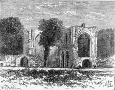
Furness Abbey
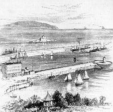
Just a word about Barrow, which we are leaving. A few years ago this town, now deservedly entitled "The Chicago of the Old World," was an unimportant fishing village, with a population of a few hundreds. Now it contains about 50,000 souls, is celebrated for its immense manufactories, and its magnificent Devonshire, Buccleuch, and Ramsden Docks (covering, with their adjuncts, 274 acres, with a stone quayage of 3˝ miles) are second only to those of Liverpool, while it is claimed for them that by the adoption of hydraulic cranes they are far more serviceable, and the patent floating docks are immeasurably superior to the old style of graving dock. Ramsden Dock, with its three fine locks, is a very pretty sight, as are also the works of the Barrow Shipbuilding Company, which are claimed as the most perfect in England.
Barrow is eminently a business town. The Steel Works, Ship-building Yard, and the Jute Works, are very extensive. It has two or three almost palatial hotels, and a Working Men's Club and School of Art. There are several fine streets, notably Abbey Road, and Duke St., and at the junction of the two is an elegant Statue to Sir James Ramsden, the founder of the town.
Old Barrow Island, a suburb of Barrow, where most of the workmen live, has a fine series of model dwelling-houses, and is exceedingly healthy ; the soil is of beautiful fine sand, and on Biggar Bank, on the west side of Walney Island, there is a beautiful grass plot two miles long, which has been bought by the Corporation and given to the town as a place of recreation. A handsome public shelter is now being erected on the ground.
But let us look at our immediate surroundings and inspect the vessel in which we are to make our journey, occupying from 3 to 3˝ hours.
In those splendid vessels, Manx Queen and Manxman, there is certainly little left to be desired. The former is perhaps the better of the two. It is nearly 300 feet long. and saloon passengers can promenade on the upper deck the entire length of the vessel, while as a provision against wet weather a covered promenade is erected more than half the length. The entire vessel is of steel, and the fittings are superb. There is a fine broad deck, an elegantly-fitted saloon, replete with every convenience for reading, writing, or resting, not forgetting a serviceable piano ; a well-supplied bookstall, a post-office, and last, but not least, a most commodious dining saloon.
The Ladies' Saloon is beautifully fitted, and there are fourteen cosy private cabins, for which only a nominal charge of five shillings is made. The Lavatory arrangements are very good. and the steerage accommodation is more complete than any we have before seen, including separate cabins and lavatories for each sex. A first-rate arrangement is that of having all the steerage seats stuffed with cork, and fitted with rope handles, so that each seat will, in case of accident, bear from four to six persons. Five lifeboats are provided, one of which can be launched in two minutes, and the others in less than ten, and the men have boat drill every week. Add to all this the fact that the culinary department is exceedingly good, we think we have said enough to assure the reader an enjoyable passage, weather of course permitting.
Now let us get on deck, and as we steam away from the pier take a look round. Behind us is the busy town of Barrow, resounding with the clang of the shipwrights' hammers, and overhung with the smoke of countless furnaces. On the right is the island of Walney, and on the left the Furness mainland, and presently we come to Peel Pier, and the remains of Piel Castle, at. the base of which the foam-crested waves dash with resistless force.
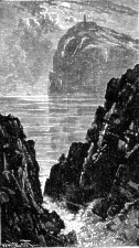
Rounding the point, and going between the two Lighthouses, we now make a straight course for Douglas, and by-and-by, looming up in the distance, see the towering height of grim Snaefell. As we near the Island on a midsummer evening, the view- is grand m the extreme. The crescent-like Douglas Bay, two miles across, lies before its ; in the dim background rises a splendid succession of lofty hills stretching from shore to shore, some dark with heather and mellowed by the soft evening light, and others bold and bleak, with their stony fronts dimly visible in the waning day.
As we come nearer, the first object to attract our attention is the picturesque Tower of Refuge, in the middle of the Bay; on the immediate left are the Victoria Pier, at which we shall presently land, and still further to the left, across the Harbour, stretches the Old Pier, and beyond that again, at the mouth of the Dhoo and Glass, the splendid Battery Breakwater, above which rises the bold promontory of Douglas Head. Right before us lies the matchless Parade, while to the right is the Iron Pier, with Castle Mona in the background, the whole forming a panorama that has hardly its equal.
Douglas Bay
WE shall probably not be in the mood for rambling about on the evening of our arrival, except it be to stroll along the splendid Loch Parade (extending from Victoria Pier, where we landed, to the Iron Pier on the north), enjoying the delicious atmosphere with which the Island is blessed.
We will therefore commence our acquaintance with the town next morning by a walk to Douglas Head, which, by ordinary travellers, may with advantage be taken before breakfast. Taking Victoria Street (the handsomest and most important street of the town) as our starting-place, we go to the top, down Athol Street, in which are the Court Buildings, formerly the Odd Fellows' Hall, the High Bailiff's Offices, and the Public News-Room, and come to the Railway Station on the right, at the head of Douglas Bridge and the commencement of the Peel Road. Crossing the bridge, and turning to the left down South Quay, the road branches off to the right by the Gas Works, and we come to Fort William, and then perhaps turn a little off the road to the left to the handsome Fort Anne Hotel, the large white building commanding the entrance to the Harbour.
Thence on past the backs of the splendidly situated mansions of Ravenscliffe House, a picturesque place, and Harold Tower, lately the residence of Martin, the celebrated painter, we pass a lane on the left leading to Port Skillion. Just beyond here, looking back, we get a very fine view of Douglas and the surrounding country, but pressing on, we are soon at the summit of Douglas Head, and enjoying the beau tiful bracing air and the grand view.
We should now descend to the Lighthouse, and get a grand view of the breakers beating round it. From here, turning to the left, we make our way to Port Skillion, a safe bathing-place at any time or season, and with the best of arrangements. Thence it is only a short distance to the Battery Breakwater, which affords a fine double promenade right out to sea, and returning along the Quay, we make our way home.
Douglas itself has many attractions. Perhaps one of the most characteristic portions of the town is the Market Place, situated on the North Quay, and which about 10 a.m., with the roadway thronged with sellers and buyers, the many coaches (in the season) starting for the various points of interest in the Island, and the bustling noise and rattle of the fishing-smacks loading and unloading their cargoes at the quay-side, presents a very lively appearance, unique and interesting.
To reach the Market from Victoria Street, we have probably gone down Duke Street, a narrow, but exceedingly busy, thoroughfare, on the left going from the Pier, and with some good shops. In the Market Place is St. Matthew's Church, the oldest in Douglas, and a very quaint structure.
Returning up Duke Street, we pass King Street, cross Victoria Street (in which is the handsome Wesleyan Chapel), and come on the right to Fort Street (leading to St. Barnabas Church and the New Pier), and just beyond, on the opposite side, is Wellington Street, where are the Theatre Royal and the large Primitive Methodist Chapel. Keeping straight on through Strand Street, where is Webb's Public Lounge, and Castle Street, which contains the Marine Baths and the Lifeboat House, we soon reach the fine Villa Marina and its splendid grounds, in front of which is the broad concrete Promenade, 1,000 feet long and 75 feet wide, and a grand place for a view of the Bay.
Just beyond is the Iron Pier, a favourite afternoon resort which we should certainly visit, and a little further on is the imposing Castle Mona Hotel, once the residence of the Duke of Athol. Beyond this again, keeping to the shore, is Derby Castle, a kind of North Woolwich Gardens, much patronised in the season, while keeping up the hill, on the left, is the road to Onchan and Laxey.
Opposite the Iron Pier is the Broadway, which shortly branches off to the left as the Derby Road, leading to the newest part of the town, and to Kirk Braddan, while the right-hand main branch, presently called the Ballaquay Road, leads to the Belle Vue Strawberry Grounds, while a branch again to the right, named Victoria Road, passing at the back of Castle Mona, goes on to Castle Hill, Falcon Cliff, and Onchan.
Turning back along the Promenade, now glistening in the sun, we turn up Marina Road and come to St. Thomas' Church, opposite which is Cretlin's [sic Crellin's] Hill, near the top of which is the House of Industry, a kind of semi-parochial almshouse.
From the Church, keeping up Finch Road, we come to Prospect Hill, where are the Government Offices, the Presbyterian Church, St. Mary's Chapel (Roman Catholic), and behind them St. George's Church. Prospect Hill, to the right, leads on towards Onchan, Kirk Braddan, and Peel, while to the left it brings us past Victoria Hall to Athol Street, before mentioned, and Victoria Street, our starting point.
It will perhaps be as well here to distinguish the four Piers which stretch into Douglas Bay. Approaching from the sea, the fine concrete Pier on the extreme left is the splendid Battery Breakwater, forming a fine broad promenade. in addition to a narrower pathway running along inside a kind of rampart which extends the whole distance from the shore.
The next Pier to our left is the Old Pier, at the mouth of the Harbour. It is built of stone, and has a small Lighthouse, used only for vessels entering the harbour. The third Pier is Victoria Pier, at which we disembarked, a fine concrete structure, and affording perhaps the best view of any. To the right of this Pier, in the centre of the Bay, is the Tower of Refuge, built on the dangerous Conister Rocks, to afford a safe refuge for any mariners who might be shipwrecked in the Bay. It is a picturesque object, and is visited by thousands in the season, small boats running from the Victoria Pier to the Tower for 1˝d.
Still further to the right is the New Iron Pier, a substantial, but not very elegant structure, though, with the promenade, the principal fashionable resort.
We have now very briefly noted the principal features of Douglas. Many most interesting walks and drives may be taken round the town by those who have time, but for particulars of these we must refer our readers to the handbooks before mentioned.
HERE are three ways of exploring the beauties of the Isle of Man-viz., by rail, by car, or on foot. As our remarks are intended more especially for the visitor who has but little time to spare, and can at any rate be but an introduction to an isle so full of beauty, we shall elect to go by rail, taking Douglas as our starting-point, noting any special features passed on the journey, and giving a short account of the various points of interest centring round each stopping-place on the way.
As a matter of detail, we are not at all sure that under any circumstances the rail is not the best method of travelling, especially on the first visit ; as not only are the distances covered in a short space of time, but the travelling is so easy, and the carriages so commodious, that a first-rate view may be obtained of the country passed through at a very small expenditure of time and money.
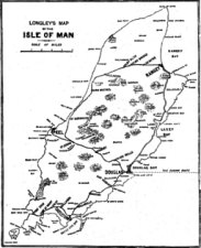
The specially-engraved map on page 7 shows the relative positions of the various stations, and we will start on our journey southward. The figures in parenthesis show the miles from Douglas, and the traveller is supposed to be facing the direction the train is going.
Leaving Douglas by an early train, we are at once in an abundance of exquisite scenery. Ascending a steep hill, we cross the rivers Dhoo and Glass (from which the capital derives its name), and get on the right as we cross the bridge a capital view of the Nunnery Grounds, beautifully laid out around a fine ivy-covered castellated mansion. The Nunnery itself (the erection of which is attributed to St. Bridget, A.D. 453) has long since nearly disappeared.
Running through a deep cutting, we pass on the left the verdant slopes of Kewaigne [sic Kewaigue], and get grand views in the distance of Snaefell, Colden, the Garraghyn[sic Carraghyn], and other mountains on the right, and Carnane Hill on the left. We now get into a cutting through the sand at Oakhill, and emerge on to the seashore, the ocean stretching in every direction before us, as, after passing the immense Ballashamrock Farm, we run into the first station,
Port Soderick (4). This point is a favourite summer resort, although there is little to see beyond the three caves (to the right from the station), one of which extends an immense distance. From the cliffs on either side of the picturesque bay may be had splendid views of the surrounding country, and the Crogga Glen, with its Fairy Well, about a mile up the stream, affords a charming secluded contrast to the wild beauty of the shore.
Leaving Port Soderick, we run through Crogga Glen, and soon get another glimpse of the sea, with Langness stretching far
away to the left. Passing on the left the beautifully-wooded Greenock or Grenaugh Glen, from whence a pretty streamlet runs
into Port Greenock or Grenaugh, about a mile distant, and with South Barrule and other mountains towering majestically on
our right, we come into
Santon (6). The scenery round here is very rural ; and Santon Church, which we saw on the left from the line, is well
deserving of a visit. Leaving Santon, we run over a steep embankment, crossing the Santon Burn, tumbling its way down to
Cass-ny-awin, just above the quaint Fairy Bridge. A little further on we get fine views of King William's College and Langness
on the left, and Bradda Head, the Barrule, and other heights on the right. The next station we arrive at is
Ballasalla (9), which, if only on account of its being the largest village on the island, is well deserving of a
brief survey.
Coming out of the station, we turn to the right, and keeping to the left, walk through the clean, prosperous-looking village, past the Primitive Methodist Chapel, over the bridge, and sharp round to the right to the gate by which we enter the grounds of Rushen Abbey, the last to be disestablished of all the monasteries in the three kingdoms. Little of the Abbey now remains, but the surroundings are most charming, and the lovely river Silver Burn running by its side, and overhung with luxuriant foliage, makes a pretty picture. Going out through another gate into the road, we turn to the right round the Abbey grounds, and coming again to the Silver Burn, and walking along its banks a short distance to the left, come to the Crossag, or Monk's Bridge, and one of the curiosities of the island. It is of great age, and is built of stone, with two arches, and only wide enough to admit of foot or horse passengers. just above is a fine mill-dam, one of the innumerable proofs of the energy and sagacity of the monks in selecting the sites of their sacred edifices. The return journey may be varied by crossing the bridge, and walking through the village.
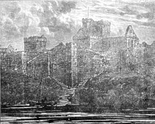
Returning to the primitive station, we follow the beautiful Silver Burn and with glimpses on the right of Kirk Malew Church in the shadow of the great mountains, and Quayle's Tower and King William's College on the left, we see before us the quaint town of Castletown, with the grim Castle and St. Mary's Chapel towering above it. Stopping short a tittle way from the town, we turn to the right on leaving the station, and crossing the second stone bridge are in the centre of
at one time the principal town of the island, and the residence of the governors. In this neighbourhood there is plenty to be seen ; and should there be time we should recommend a stay till the morning. First of all we must visit
The Castle, which, strong and dark, seems to pervade everything. The entrance is immediately to the left on crossing the bridge, and if we are fortunate enough to find a party of visitors waiting shall, for a fee of 4d., have an opportunity of inspecting it. The building is supposed to be about nine hundred years old, and is a finely-preserved specimen of an ancient Danish stronghold. It has a battlement nine feet thick, with seven square towers, and was once surrounded by a moat, which is now partially filled up. The Clock, which has only three wheels, has been going for nearly three hundred years, and is apparently equal to going for another three hundred. At the entrance, at the head of some stone steps, is the Rolls Office, and passing under a lofty portcullis, we see a flight of steps which leads us to the Ramparts, from whence a fine view of sea and land may be obtained from the coast of Ireland on the west, and Anglesea on the south, round to the mountains of Cumberland on the north-east, with the more adjacent panorama of the island itself, and the town nestling at our feet. Tradition tells many strange tales, more or less incredible, respecting Castle Rushen, one of which is that it has underground a series of magnificent apartments which mortal man cannot reach. However that may be, it has stood several sieges, and played an important part in the history of the island.
On leaving the Castle we turn to the right and round into the Market Square, a fine open space, on one side of which are the Barracks accommodating about fifty men, which constitute the whole military protection of the island. On the other side is the Custom House, and at one end St. Mary's Chapel, built upon the supposed site of an ancient heathen temple. In the centre of the square is a Monolith, in memory of Governor Smelt, and close by is a remarkable Sun dial, which is said to tell the time by night as well as day.
In the neighbourhood of Castletown are many delightful walks, the favourite being to the Scarlet Stack. Turning out of the marketplace down the street in the corner by St. Mary's Chapel, and along the shores of the Bay, with Langness on the opposite shore, we pass in front of a large house with a well-laid-out garden, and an extensive limestone Quarry, and are soon at the base of the jagged mass of black basalt we have come to see. Clambering over the pointed rocks, should it be low water, we mount to the summit of the Stack, which. commands a grand view. Returning to the shore, we continue our walk along the green sward round Poolvash Bay, lovely in its ever-changing scenery, and presenting a remarkable contrast to the wild desolation of Poolvash, which we shall presently reach, and from the quarries of which the black stone was hewn for the steps of St. Paul's Cathedral. From this point a road leads us past Balladoole House to the main road for Castletown.
Another very interesting walk is that to the east. Crossing the river, we go down the Douglas Road, and turn up to the right past the prettily-situated houses called The Green, and get on to the shore. Soon we come to Hango Hill, supposed to have once been a place of execution, from the quantity of human remains which the inroads of the sea continually bring to light. Opposite the hill is King William's College, a fine building, and of great repute throughout the kingdom. A little further on is the Racecourse, where, two hundred and fifty years ago, was instituted by Earl Derby the "Manx Derby," from which sprang our English " Derby."
We are now at the pretty little fishing-village of Derby Haven, acknowledged to be the finest natural harbour of the island. From the centre of it extends a splendid Breakwater, to the right of which is a narrow strip of land connecting the headland of Langness with St. Michael's Isle. This wave-beaten little island must not be forgotten. On it are the ruins of St. Michael's Chapel, of great antiquity, and Derby Fort, some two hundred and fifty years old, with, walls of immense thickness. A lighthouse has recently been erected on the walls.
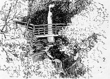
Natural Arch Langness Point
Should we have, time, our visit maybe very pleasantly extended round Langness Point, interesting, as it is at every step. The whole distance round, from Castletown and back, is about seven miles. The rock scenery is most enchanting, and we presently come to the Martha Gullet, a romantic cleft in the rock, and then. to a round tower which is known as the Landmark, though of but little practical use. Passing the wonderful formation called the Natural Arch, and rounding Dreswick Point, and by the shores of Dreswick Harbour, we come to Langness Point, when the whole beauty of the southern extremity of the island, with the Calf of Man, the Chickens Lighthouse, and the Spanish Head prominently in the foreground. Walking up the inside of the peninsula, we get a delightful picture of a great part of the island.
Resuming our railway journey, we run inland through pretty country, passing Arbory Church on our right, and then with a
fine view of Bradda Head and Port Erin Bay on the left, pass the tiny station of
Ballabeg (12), with its pretty white Church nestling among the cottages on the hillside, and rum quickly on to
Colby (13), in the neighbourhood of which are some very extensive Lead Mines, and the remains of a Druidical burial-place.
The next station is
the principal fishing-village of the island, and presenting a very busy scene in the season. We might from here take a small boat to the Chasms. Rounding Kallow Point, crossing Perwick Bay, and passing a grand series of cliffs towering almost vertically into the air, among them being the far-famed Sugar-Loaf Rock, covered -with sea-gulls, we land in Stacka Bay, and climb the giddy height, from which we li.k down some five hundred feet on the wildest imaginable scenery
"Rent by the solemn earthquake's dreadful might."
From here we make our way, further southward, either by land or water, and next come to Spanish Head, a grand headland, where, if tradition speaks truly
. " The fleet of Spain,
At least a portion, struck, and here was lost ;
The great Armada in a hurricane
Was cast upon this shore."
If -we have journeyed so far by water we shall continue our way, providing the sea is not too rough, to the Calf of Man. The current here is very strong, and often no communication can be obtained with the mainland for days together. The Calf Island is about six hundred acres in extent, and its summit is five hundred feet above the level of the sea. The great attraction of the island is its rugged savage beauty, the crested waves dashing with relentless fury against its jagged rocks, and scattering the foam like a shower of silver on every hand. There is nothing on the island but a xuined but and thousands of rabbits, though it was once a fortified stronghold. Standing by the house, we can see two very singular rock formations, called the Burrow and the Eye, which, when looked at from our boat, are grand in the extreme, the sea having forced its way through the solid stone, rushing and roaring with deafening violence. On the Chickens' Rock, a dangerous reef, a mile and a half south of the Calf, is the Chickens' Lighthouse, a handsome grey granite structure, 130 feet high, and forming a conspicuous object by day or night.
Continuing our journey round the Calf, we come again to the mainland, and soon, should the wind be fair, enter the bay of
Bradda Head
Grand, indeed, is the scene as we enter the bay.. Behind us stretch the magnificent headlands we have just mentioned; on our left is Bradda Head, towering like some giant of old far up to the heavens ; on the right Cassells Head and the low but very effective Breakwater, and above it the hills of Mull rising clear and bright, while before us lies the picturesque Port Erin itself, with the Falcon's Nest Hotel standing prominently high up in the foreground. Once in the bay the scene is changed, and all is quiet and still; the quaint fisher folk mending their nets hardly breaking the stillness of this old world village. One feels they could stay here and dream for a hundred years, as if in some enchanted spot of fairyland.
We had better land at Port Erin, from whence it is but a short walk to Fleshwick Bay, a charming place, but one seldom visited by tourists. Those who are fond of climbing should, emerging from the Falcon's Nest, turn to the right and keep the lefthand road, and take Bradda Head on their way, the scenery during the ascent and from the summit being remarkably grand. On the Head are the Milnei Tower (built in memory of the celebrated safe-maker, who resideč here), and the offices of a mine, lately reopened. Fleshwick Bai is reaches' by a steep descent, ane is very wild in its seclusion. It lies sheltered between Carnane and Bradda Hill, and has a pretty little white pebble beach, and on the north side are some picturesque rocks and caves. Returning by the road, we come through Bradda village, and half a mile further are again at Port Erin, from whence we return by rail to Douglas.
For our next trip we will journey, westward. Again passing the Nunnery, we branch off to the right, over the Glass, by
the luxuriantly-wooded Spring Valley, and the fine mansion of Kirby, and get a beautiful view of Kirk Braddan old and new
churches on our left. Then running under and by the side of the Peel Road and crossing the Dhoo, we reach Dalrymple's Mills,
and are at the first station,
Union Mills (3), with its pretty church on the right. This is perhaps the best point from which to visit
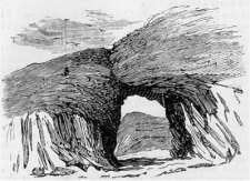
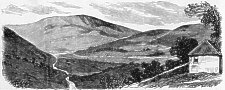
Kirk Braddan, lying about a mile distant, or it is a pleasant walk from Douglas. The quaint Old Church, of which we give
an illustration on our first page, is most interesting, both on account of its great age and its picturesque surroundings.
It is built on the site of one erected in the thirteenth century, and the crowded churchyard is a solemn testimony to its
antiquity. In various parts are seven very curious sculptured memorial-stones, with inscriptions in the Scandinavian dialect,
dating from the twelfth century ; and a modern one. erected by a Rev. Mr. Patrick Thompson to his own memory eleven years
before his decease. The old church was so greatly crowded in the summer time by visitors to the island, that it was thought
desirable to erect the handsome new one which stands close by.
Nearer Union Mills, and very pleasantly situated between the Dhoo and the Glass, is the fine building of the Isle of Man Lunatic Asylum, one of the best of its kind. We get a good view of this building from the railway just after we leave Union Mills, where we will now return.
Jogging along past cheerful-looking villas and farmhouses nestled among the trees, we see on the left the tall shaft of
the Foxdale Mines, and Marown old church on the high ground in the distance, with the pretty little new church on the right.
We now come in full view of the majestic Greeba Mountain, charmingly situated at the foot of which is the pretty little
village of
Crosby (5). After a stroll through this interesting hamlet we make our way towards Greeba, a rugged mountain 1,000
feet high, with the ivy-covered castellated mansions of Stanley Mount and Greeba Castle on the lower slopes, from which
a glorious view may be obtained on a clear day. Part of the face of the mountain has been very tastefully laid out and planted,
and many picnics are held here in the season. Descending to the level we shall doubtless stroll on to the roofless ruins
of St. Trinian's Church, situated in a field about a mile from Crosby. They are very picturesque, and their origin, shrouded
in mystery, has been a fruitful source of antiquarian wrangling for many years past.
A longer walk, but one that should certainly be taken if time permits, is that to Glen Darragh, about seven miles. Crossing the line and the Dhoo, we climb Archallagan Hill, on-which is Marown old church, which we saw just now from the train. Turning up a lane on the right, a little beyond the church, we come to some stones set upright in a field, and called St. Patrick's Chair, in which tradition says the saint sat to bless the people. Returning to the road, we proceed till four roads meet, and taking the one on the left, trudge on through the village of Cooil, skirting the foot of Mount Murray until we come to another series of Druidical remains called the Stone Circle, and probably marking the site of an ancient burial. ground. We then get a lovely view of the surrounding country, with the giant hills in the background.
Resuming our railway journey, with the two Greeba mansions on our right, we pass on the left the Ballacurry river, which
finds its outlet at Peel, past the Round Meadow, and presently see ahead of us the Slieu Whallin mountain, Corrin's Tower
on Peel Hill, and running by Ballacraine, and through a sandstone cutting we see the Church, and are at the little station
of
St. John's (9). From this point we shall turn a few yards to the right to the main road, and visit the Tynwald Hill,
a small grass-covered mound rising in three steps to the point at which a flag-staff is erected. This mound, insignificant
as it seems, is the palace of justice of the island, and no law can take effect until it has been proclaimed from Tynwald.
The annual proclamation day, which is in July, is observed as a ;eneral holiday throughout the island, from every part of
which stream the holiday folk ia gala attire to witness this relic of bygone ages.
Opposite Tynwald is St. John's Church, an elegant little building, and close to it a pretty Nonconformist chapel. A little over two miles from St. John's is the lovely Glen Helen, unique for its sylvan beauty among the wild fastnesses of Mona. Taking the road passing the Tynwald, we soon come to the Neb stream, which flows direct into the Glen, and following it, we presently cross a wooden footbridge, and get into Glen Mooar. Here we shall see the beautiful baby Suspension Bridge leading to the Quarries and the Swiss Cottage, a charming Hotel belonging to the Company owning the Glen. The natural advantages of the place have been greatly enhanced by planting an immense number of trees of every variety, and the Manx people seem to appreciate the enterprise, which is very successful. Following the right-hand side of the stream for about a mile, we come to a spot where the water divides, the branch on the left hand tumbling down some twenty feet through a narrow gorge, and forming the far-famed Rhenass waterfall, to the top of which we may ascend, and be well repaid for our trouble.
Continuing our journey by the iron horse from St. Johns, with the Ramsey line branching off to the right, we cross the NeG, pass the Abbey Clay Works, and again meeting the pretty little river, follow by its side, getting on the left a glimpse of St. Patrick's Church, overshadowed by the grim Cronkna-Irey-Lhaa, and Peel Hill surmounted by Corrin's Tower, shortly after find ourselves at
The principal and almost only attractions of Peel are the ruins of the Cathedral and Castle, of which an illustration is given on the next page. Turning out of the station, and to the left down the Quay stone pier, to the right of which is the strand, with its quaint fishers' houses, can take a ferryboat to St. Patrick's Isle, or which is far better, we can - cross the footbridge at the top of the Harbour just above the station, and walk along the top of Horse Hill, which is joined to St. Patrick's Isle by a narrow artificial causeway. From the hill a fine view of The Castle is obtained, together with the safe and commodious Harbour, which, in the fishing season, often shelters a hundred and fifty sail. We enter by a very ancient portcullis over a thousand years old. Everything is old and ruinous, but magnificent in its decay; the immense pillars, the widespreading arches, and disused altars cannot but impress one.
PEEL CASTLE.
Taking first St. Germain's Cathedral, dating from the fourth century, we are struck with its grand proportions. Its history is of the most romantic character, and we must not omit to inspect the crypt, and its secret passage, which could no doubt tell many a weird and ghostly story.
After exploring the cathedral, we proceed to the Palace, a very primitive structure, though at one time the episcopal residence. Adjoining it is what was once the private chapel, close to which is a modern building used as a guard-room, in which are some very interesting relics, which the custodian will readily show. Glancing at the old well, and looking over the walls, we have a good view of the recently erected stone Breakwater, which forms a very pleasant esplanade, at the end of which another pier with a lighthouse is being constructed.
Close by was the entrance to the old sally-port of the Castle, now bricked up; and a little farther on is Moore's Tower, once a prison for the incarceration of civil offenders. Just here is Fenella's Tower, immortalized by Sir Walter Scott in " Peveril of the Peak," and one of the most interesting portions of the Castle. In the centre of the stronghold is the Round Tower, built of red sandstone, on the highest point of the island, and a landmark for miles round. Between this Tower and the Cathedral are the remains of old St. Patrick's Church, also built of the red sandstone which abounds in this neighbourhood. Several other ruins are also to be seen, including the Armoury and the guard-house, and outside the walls is the Giant's Grave, to which a most romantic legend attaches.
There is little else in the town to demand notice, unless it be the ancient Marketplace, the Church, and the Strand, and it is now time to find our way back to Douglas.
Owing to the hilly nature of the country north of Douglas, there is no direct railway in that direction ; and we therefore
travel along the Peel line again as far as St. John's, where, with good views of Peel and its surroundings in the distance,
we branch oft to the right to the new station of
St. Germain's (12). From this point we run due north until we touch the western coast at the White Strand, and then
have a fine run along the summits of the cliffs, with splendid views on either hand, and Peel at our back and passing a
rugged place called by an unpronouncable Manx name, signifying the" Mouth of the Devil," and over three bridges spanning
some lovely glen scenery, we next reach, at the foot of Slien Curn, rising dull and sombre to the height of 1,350 feet,
the pretty little village of
Kirk Michael (16), noted for its clean bill of health. The Church is a fine substantial edifice with four towers,
and in the Churchyard is the monument to the celebrated Bishop Wilson. There are some Druidical remains close by.
Resuming our railway journey, we come to the quaint and pretty little village of Ballaugh (t9), in which, about a mile
from the station, and near the shore, on our right is a lovely ivy.coveredchurch that will delight the artistic eye, and
containing a very curious old font. A short distance from the station is the Bishop's Court, a plain, substantial building,
and the official residence of the Bishop cf Sodor and Man. Further inland is Glen Mooar, in which is situated the celebrated
Spooyt Vane waterfall a magnificent cascade, with a descent of over sixty feet. Druidale and Ravensdale, two most charming
glens, are in the neighbourhood.The next station is
Sulby Glen (21), most beautiful in all its varied aspects, while the Sulby river affords some splendid trout fishing,
and grand specimens of almost every variety of ferns. This is the best point from which to visit Snaefell.
Sulby Bridge (22) is close at hand, and we next come to
Lezayre (24), round which is some charming scenery, embosomed in which is the quaint old parish church on the right.
Four miles further on we come to the picturesque town of
charmingly situated at the head of Ramsey Bay. The town is an important one,, built in the form of a semicircle, and has an excellent promenade, with a concrete foot way. First-rate sea-fishing may be had here, especially near the Bahama Bank, the light of which may be seen seven miles out from the pier.
Ramsey looks very prosperous, and has some fine shops and public buildings, while the Quay is the pride of the town. The Market-place, the best in the island, and once forming part of the harbour, St. Paul's Church, the Almshouses, and other prominent buildings deserve a passing glance.
The suburbs of the town are very interesting. Half a mile away is the Ballure Glen, fairylike in its rustic beauty, and a little further on is the Albert Tower, built in commemoration of a visit to the island by the late Prince Albert.
Then there are the Elfin Glen, May Hill, and Summerland, all charming spots worthy of a visit. Maughold Head is about four miles out of Ramsey, and should be seen for its picturesqueness, and the interesting historic associations clustering around it pointing it out as the landing-place of St. Maughold, the supposed discoverer of the island. There is a curious old church and an antique sundial, together with several remarkable crosses, all of very ancient date.
is perhaps best reached by car from Douglas, as we thereby get a view of the east coast of the island, which the railway does not traverse. The road leads from Douglas Bay over Burnt Mill Hill, past Bernahague, it one time the Governor's residence, through the village of Onchan with its snug little harbour, and quaint old church by Growdale, and Lonan Church to Ballagawne, where are the Cloven Stones, supposed to mark an ancient place of interment.
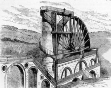
Laxey Wheel
Descending to the valley, we get a fine view of Laxey Bay, and soon find ourselves at the entrance to the world-renowned Lead Mines. The Laxey Wheel, of which we give an illustration, is reputed to be the largest over-shot water-wheel in existence, and a visitor to the Isle of Man would be thought to have failed in his duty did he not ascend and inspect this triumph of skill, of which the islanders are justly proud.
Snaefell
Near Laxey is the giant mountain Snaefell, " the pride of Mona," the nearest station to which is Sulby Glen. About six miles north of Laxey is the farfamed Dhoon Glen, a lovely spot indeed, with two magnificent waterfalls, one above the other, seventy and sixty feet in height. They form a beautiful sight, and if we have time we should follow the course of the foaming torrent till it loses itself in the sea.
Dhoon Waterfall
Many other places of interest are to be found in the island, for particulars of which we must refer the reader to the many excellent guide books published.
Our object has been to briefly survey the principal features of this beautiful gem of the sea, and if what we have written should induce our readers to explore its shores for themselves, we shall be amply repaid, and rest assured that they will never regret the journey.
|
|
||
| |
||
|
|
||
|
Any comments, errors or omissions gratefully received
The Editor HTML Transcription © F.Coakley , 2010 |
||