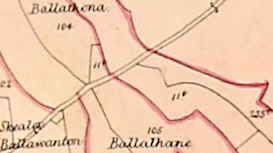
Thanks for the advice, Frances! Yes, I've been all over Wood's Atlas and Index. As recap, my 4th GGrandfather sold the land in question in 1826 to John Callow. Callow emigrated to Ohio, where he died in 1876 - after the 1869 date of Wood's. To my knowledge, he still owned the land even though he was in America, allowing a relative to live on it. The only John Callow I see in Wood's Atlas Index owned parcel 1IT, Ballathona. The resolution is low so I've included the section of the Atlas here. Does this look like 1IT to everyone? Anyone have a more clear copy? Would make sense because many of the neighbors are the same families as in the deed of sale from 1826. Also, if I'm reading Wood's correctly, it was about 13 acres - similar to the 12 acres listed in Thomas Tear and the Deed. Seems convincing ...
I believe that a croft or two closer to the sea also came with the original sale, but can't prove yet.
Couple questions (thanks for being patient!):
1. If 1IT is the property, then it should be on microfiche per the tithing system, as you mention. Seems only at Manx Museum; wonder if anyone has this info?
2. Per Wood's Atlas, any idea how I'd determine where this plot of land 1IT would be current-day - that is, GPS coordinates, landmarks, etc.?
3. Yes, I figured Lib Assed would be the place to look for property transfers. I know you've done a wonderful job of transcription. Does anyone know of an online transcription from around 1801 (transfer Thomas Moore to Joney Teare aka Moore)? Or should I order LDS film 106639 which covers the "Manorial Rolls" for 1797, 1816, 1858, 1869? I assume that Lib Assed was collected only in those years? Correct, or was that only what was filmed by LDS?
Finally, thanks for the 1:2500 Ordnance Map CD-Rom tip. I emailed mapping (at) gov.im today to inquire - stay tuned! One can buy printed, paper copies of select areas. Happy to provide that pdf to anyone who is interested. Best, Lyle.