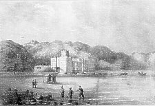
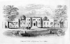
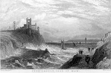
Castle Mona
160 × 195 mm
Castle Mona was built as the residence of the Duke of Atholl in 1804 to the design of George Steuart. It was converted to an hotel in 1835 though allowed to fall into disrepair from c.2000 and currently sold with future uncertain.
160 × 195 mm
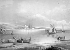
A second view in a similar style shows the view of the newly constructed Tower of Refuge.
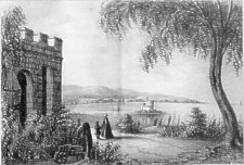
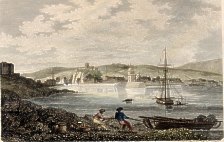
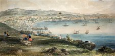
Bay of Douglas & Tower of Refuge
from Fort Anne
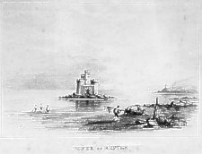
Tower of Refuge
160 × 195 mm
A third view, presumably in the same set as lettering, size and style are very similar, is also of the Tower of Refuge.
Classic view of Douglas Bay - showing Harold Tower in foreground. 1840s ?
Imprint "Madeley lith, 3 Wellington st Stand"
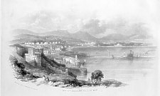
Bay of Douglas, Isle of Man
Hampton Court
115x190 mm
W. T. Bell del; W. Kneale Douglas
William Kneale was not a printer but published several works 1856-1870. Cubbon rates him highly as a literary figure.
The view is too large to have been part of any of the 3 editions of his guide book.
Hampton Court is near Port Soderick, Braddan and was built c.1800 by Thomas Stowell.
97 × 150mm
Imprint:
Engraved by W. Birrol from a drawing by W.K. Watts for the Beauties of England and Wales.
London Published by Vernor and Hood, Poultry, April 2 1804
Drawn from near Battery Pier, shows Douglas Red Pier and light, to the left can be seen the old fort (used as a lock up) which was demolished in 1818. Standing proudly some distance out of the town is the then new St George's Church.
From vol 3 E.W. Brayley and J. Britton The Beauties of England and Wales ; or, original delineations, topographical, historical, and descriptive of each county. London 1802- 8mo
Douglas. Isle of Man
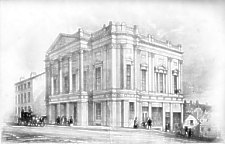
Odd Fellows' Hall, Douglas, Isle of Man
Erected 1841 , J & H Robinson, Architects and Builders
To the Grand Master and Board of Directors, Manchester Unity this drawing is respectfully dedicated.
Imprint is T.T. Bury, Lith from a sketch by J. Jefferson; Day & Haghe Lithrs to the Queen
presumably done for the Oddfellows' conference in Douglas in 1841; the hall was an over ambitious venture and shortly afterwards was sold eventually becoming the Douglas Courthouse until replaced in the 1990s.
106 × 85 mm
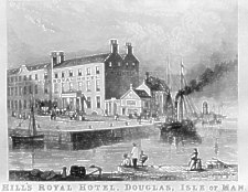
Built as town house of Bacon family (of Seafield/Arragon) c.1790, became hotel 1848, closed c.1914.
William Hill was owner from 1848 to about 1875 when his son-in-law took over.
The view is from a 'flyer' for the Hotel and dates from c.1856. - the corner became known as Blore's Corner as Blore's tobacconist shop occupied the small building from c.1850 to c.1881.
The paddle steamer could be the King Orry I - sold 1858
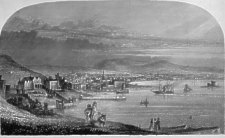
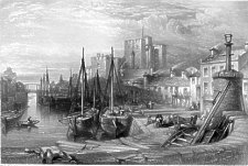
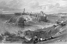
Castletown, Isle of Man.
232 × 330 mm
(slight loss of side margins & top due to scanner)
Viewed from Scarlett - shows lime lime kiln at left, Castle Rushen and St Mary's in centre with King William's College to right
The copy in the MNH Library has the inscription "Published by J. Quiggin 1841" underneath the title (excised from my copy)
Inscription - 'On Stone by W Physick; T Physick lithr Manchester; W Kinnebrook delt"
William Kinnebrook is noted as author of the earliest book illustrating the Manx Runic crosses - T Physick noted as Lithographer and publisher of sporting prints at 90 King St, Manchester c. 1838; two notes in the Notes and Queries section of Manchester City News (19 & 30 May 1903) give a lttle more info stating that Thomas Physick was born at Lancaster and died in Manchester (no dates given ) - the second correspondent suggests that William was the painter and Thomas an engraver, found in 1838 and 1840 at 71 King St but had gone by 1851 (thanks to Manchester Archives and Local Studies for the information)
232 × 330 mm
(slight loss of side margins & top due to scanner)
In the Manx Museum there is another view by W. Kinnebrook also inscribed On Stone by W Physick and "Published by J. Quiggin 1841" - this one of Douglas as viewed from above South Quay
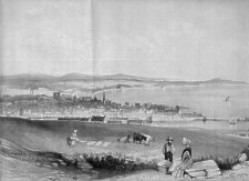
Douglas, Isle of Man.
Douglas Isle of Man
168 × 282 mm
View from Douglas Head - dated c.1850 as shows St Thomas's (with its intended but never built spire), the houses on left are Fort Anne (showing only the left wing, the central block is in shadow and the right wing obscured) & Falcon Cliff (then home of Edward Downes), Harold Tower is I think off the view to the left. The old courthouse is I think visible at the end of the red pier (dating it thus pre 1860) - if the identification of the spire is that of St Thomas's then probably dates c. 1848/9 during building work as non-erection of spire known post 1850.
Inscription R. G. Adamthwaite Del & Scult.
Missing from my copy but found on a copy in the Manx Museum is the imprint "Published by Samuel Johnson Duke Street Douglas" - this dates it post 1847.
Richard Greaves Adamthwaite was born about 1823 in Salford, the son of Thomas Adamthwaite (a tailor), living in Salford in the 1841 and 1861 census, in 1841 he was an engravers apprentice, in 1861 he gives his occupation as 'artist (painting and engraving)' - there is no sighting post 1861
It appears to be a woodcut mounted on linen backed paper (though this may well be modern)
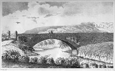
Peel Bridge
From an unknown book - possibly a guide book though search through
my own and the Manx Museum Collection has so far failed to locate it.
Lithograph image 92mm x 59mm on a page 123mm x 79mm - artist Charles
Marshall noted as a minor english landscape painter 1802-1890, many
of the relatively few works located include river scenes - lithographer
W. Backshall( for whom I can find only one other online reference to
a lithograph of c.1850) - possibly both were from the English Midlands.
The view shows what is today called Fenella beach formed on the southern side of the causeway linking Peel Castle to Peel Hill - this causeway was originally a simple breakwater, built at instigation of George Moore, started in 1740 and finished 'with great difficulty and danger' in 1757. It was widened and strengthed during the Napoleonic era when Peel Castle was used as to house a gun battery - in late 19th century considerably widened to give todays vehicular access to the late 1890s breakwater.
Considerable artistic licence has been used to magnify the height of the walls above the sea level - the lighthouse at the end of the quay (seen right mid picture corresponds to that of the mid 1850s but by then the causeway was shown in other views as considerably wider.

Albert Hotel Ramsey as viewed from the Beach
View of the Capital Part of the Isle of Man
Sold by Bickham in May's Building
An Anthropomorphic Landscape - whether connected with the Island is not clear - the "Isle of Man" may be a reference to general mankind the head (ie capital part) is shown as a landscape (if not clear rotate the image 90deg clockwise).
George Bickham (c, 1704-1758) the younger was one of the earliest political caricaturists, in 1750s was trading from May's Building Covent Garden; his father George (d 1769) also practised engraving but his output is thought not to have much merit - The Isle of Man came to the notice of London Society in 1765 with the revestment so if the image is related to the IoM then possibly the engraver is the father.
Based on an original by Wenceslaus Hollar(1607-1677) who came to England in 1637 where he remained until his death - buried as a pauper at St. Margaret's Westminster.
 .
.
Hollar's original
This and the following two views are found in Peveril of the Peak as printed in Vol VII of Waverley Novels printed by Robert Cadell Edinburgh in 1845. There are produced by engraving very fine lines which merge together to provide significant variation in texture.
The two names under each image are W L Leitch and W Forrest - Leitch is the artist and Forrest the engraver. William Leighton Leitch(1804-1884) was a scottish landscape painter mostly in watercolours, drawing master to Queen Victoria + the Royal Family for 22 years - based in London from 1837 onwards.
The Castletown portrayed here is consistent with the early 1840s.
89 x 130mm
Castletown Isle of Man
89 x 130mm
Peel Castle Isle of Man
Viewed from the path leading up Peel Hill towards Corrin's Tower - looking
down onto the beach formed by the mid 18th construction of the causeway
linking the South Quay to the Castle on St Patrick's Isle, which beach
became known as Fenella Beach from the fictional heroine of the immensely
popular novel Peveril of the Peak by Sir Walter Scott set partly
in Peel Castle and elsewhere on the Island during the latter period of
the English Civil War.
The artist has distorted St Patrick's Isle in his rendition as seen from photo taken near to spot
The view I think is from east of the waterfall at Glen Maye and the house that stands just above the tree line is maybe what later became the Waterfall Inn with Ballachrink farm on the hill to the left. But like his view of Peel castle he exagerates the vertical.
The choice of subjects would indicate that he was commisioned to draw these views..
89 x 130mm
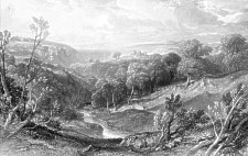
Glen May Isle of Man
245 x 400mm
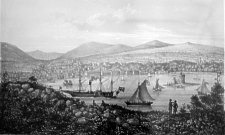
View of Douglas Bay, Isle of Man
Imprint Day & Son Lithrs to the Queen
Wm Day started a lithography business in 1823/4 though in the 1830s the company usually operated as Day & Haghe, Louis Haghe being a fine artist who worked for the company until 1852. Wm Day senr died in 1845 leaving the company in the hands of his son Wm - with the company then becoming known as Day & Son.
The lithograph thus dates post 1845.
Imprint Vincent Brooks Lith London
Published & Sold by Kerruish and Kneale
Booksellers & Stationers, Duke St Douglas
Vincent Brooks started in business in 1848 though not clear when he commenced the lithography business though some pieces were displayed at the 1851 Great Exhibition.
H & D Kerruish produced a Hand Book for Visitors in 1849, which went into several editions, the 3rd of which was published by Kerruish & Kneale, 38 Duke-street and dated to c.1853. They removed to 'more commodious premises' at 37 Duke St in May 1855 [notice in Manx Sun 5th May]
A newspaper advertisement dates this lithograph to 1856.
Mona's Herald, Wednesday, June 11, 1856:
NEW VIEW OF DOUGLAS
By the Lithographer to the Board of Trade Department of Science and Art.
KERRUISH and KNEALE have just published a beautiful Lithographic VIEW of the BAY and TOWN of DOUGLAS. This Lithograph is the production of VINCENT BROOKS, who, it will be remembered, had the distinguished honour of being elected by the "Art Exhibition Branch" of the Patriotic Fund Committee to delineate on Stone the Drawing of "The Battlefield," recently executed by the Princess Royal. In anticipation of an extensive demand for this beautiful work of Art, the circulation of which throughout the United Kingdom will prove of great advantage to the inhabitants of the Isle of Man, KERRUISH and KNEALE have determined to publish it at a price that will enable any person to possess a copy.
Price, uncoloured .. .. ..2s. 0d. Coloured 3s. 6d.KERRUISH & KNEALE, PUBLISHERS 37, DUKE STREET.
The Brooks company later bought out Day & Son in 1867 after that firm went into liquidation - it continued in business until WW2 producing many well known illustrations, eg the weekly caricatures in Vanity Fair and many of the posters for London Underground.
255 x 510 mm
Douglas, Isle of Man
(with a view of the Royal Squadron,
on the Occasion of the Visit of H.M . The Queen)
The visit to Douglas bay was a brief stop of a quarter of an hour stop at 11am on 14th August during the voyage to Scotland. The Manx Sun [21 August 1847] has a description
The Royal squadron consisted of the Victoria and Albert, the Fairy, Garland, and Undine. The Manx boats accompanied the squadron to Douglas bay, the Royal yacht taking the lead, closely followed by the Fairy, Garland, and Tynwald, the other three steamers not being able to keep up with them....It was about 11 o'clock when the squadron entered the bay, where it remained for about one-quarter of a hour. ... The Victoria and Albert, on board of which were Her Most Gracious Majesty and Her Royal Consort, the Prince of Wales and the Princess Royal, the Duchess of Norfolk, Earl Grey, and other noble company, was the centre of attraction, and thousands of loyal subjects were anxiously looking for Her Majesty, who soon appeared on the platform, accompanied by Prince Albert and the Prince of Wales. Her Majesty wore a cloak, white bonnet with blue veil, and appeared to be sketching the town and bay...
A.W.Moore's History of the IoMSPCo has a supposed illustration of the scene.
On the return of the Queen and party in September 1847 there is an account of their visit to Ramsey Bay during which Prince Albert, the Royal consort, left the Royal yacht for a brief visit to Ramsey.