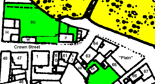
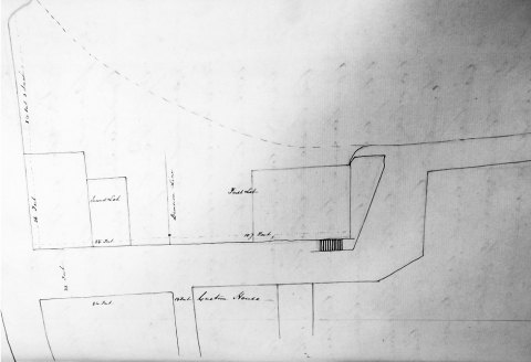
Crown Street
The base map used is the OS 1868 plan of Peel; the inserted numbers are my
own though 1-47 those used by the author of the text referring to Castle
Street that accompanied the elevations. The elevations date from c.1890
- I was given a copy but as yet have not determined the source though I think
they are based on information supplied by one of the Goodwin brothers - see
article in Mannin (I have tried not
to repeat too much of what is here but to add to his account).
The name Crown street is used here though this is a modern name
adopted 1874.
|
1869 plan
|
Crown Street
BG - Sir George Moore's Bowling Green
W - watch house
P -Police Station
R - Rocket House
46 - Courthouse (see Castle Street)
47 - Peveril Hotel
48 - Warehouse
1 - Marine Hotel (pre 1890 fire)
60 - Marine Hotel Annex
61 - Marine Hotel Annex
62 -
63 - Munn's
64 - Munn's
65 - Barracks
66- ? Caledonian Hotel (1848)
67 -
68 - Wattleworth's
69 - out buildings, Shown on 1784 plan
|
The area is now considerably altered with further shore reclamation allowing
the shore road to continue around the north before joining the quay.
The area marked BG is what remains of Sir George Moore's Bowling Green - it
is on reclaimed land, comparing Corris's plan of 1784
it would appear that it was square and that only the lower 2/3rds
was remaining in 1868 (Wilson's plan of 1791 shows
it as having decayed though Corris in 1784 shows it entire). The first was #150
under German Intacks dated 7th August 1735 - for a wast in the strand opposite
to Rich Radcliffe & Phil Kewley & joining to Jo Callister and his own
rent fifteen yards broad in the east end & thirty yds broad in the west
end outwards & in length sixty four yards reserving a street or road of
eighteen foot to the harbour - rented to (vide Lib Scaccar 1735 for the composition).
The 18 foot to the habour is I think the width of the quay on the west side
(possibly not yet built at that time) and not the width of the Crown street".
This was added to in 1738 (Intack #164) by "a parcell of wast ground on the
shore in Peeltown adjoining the intack lately taken by him and extending outwards
from the sd intack sixty four yards long & seaward into the north end from
the intack aforesd ten yards and in the east end twenty five yds deep - rented
to - vide L. Scaccar 1739 for the composition" which completed the square. According
to Goodwin this land was used for boat building, certainly from late 1840s
and probably before.
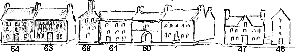
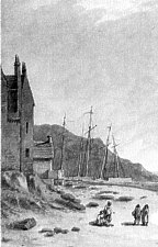
Crown Street and Shore Road c. 1880
The entrance to Crown Street was shown in a small engraving dating
c.1825 and sketched below:
The building on right is warehouse marked 48. The corner seen
centre view, is now occupied by the Custom House and Harbour Office
built about 1863 supposedly on site of Winter's
public house which is possibly the two storied house on the Quay,
the other chimneyed building may well be the 'Watch
house' public house described as just around the corner. Corris's
plan of 1784 shows a building on the corner, a long building along
most of the green (presumeably a storehouse as the engraving shows no
chimney) and another building at what is now occupied by the old
police station.
The Police
Station dates from c. 1847; the Rocket House which housed
apparatus used to throw a line to vessels at sea and under charge of
a Rocket Brigade dates from c.1876 though is now demolished, forming
part of the Yacht club premises.
Peveril & Warehouse - #47 & #48
The name Peveril is that of the current hotel - the name appearing
by the mid 1850s and derives from Scott's story 'Peveril
of the Peak' which had some scenes set in Peel Castle.
In Lib Assed under Intacks is
#165 dated 7th May 1741 rented to Mr Pat Savage "a parcell of wast
ground ajoining a little house lately by him purchased near the shore
in Peeletown - extending from the north corner of the purchase - five
feet broad and from the south corner of the purchase seven foot and a
half running in a direct line from the corner of Mr Geo Moore's house
towards the river".
In 1815 was
advertised "A large and eligible dwelling house, with kitchen,
parlour, drawing room, four bedrooms and garrets, with a very good
yard. The premises are attached to the quay and very fit for a
genteel family or a person in business."
The 1848 plan in the Leece Museum shows a yard in the position
corresponding to the warehouse. #48 which however must predate the
quayside frontage of the Courthouse (?
1862)
Marine (#1)
Much of the history has been told by Goodwin in "Old
Peel " in Mannin. This (or at least part thereof) and the
adjacent Wattleworth's are Abbey Rent and are entered as Cottage #3
on the list.
In 1607 the two properties were entered under William Bridson for 6d rent,by 1703 split into two 3d rents Jo Kermeen ('Wattleworths')
and Thomas Radcliffe who it would appear sold the property to George Moore in 1758 which would appear to support conjecture
that this was the the eastern annex (shown as 60 + 61 on plan) as George Moore's house was built by 1741.
Sir George Moore's House + Property (#60 + #61, BG, H + W)
George Moore's sons were a great disappointment to him being spendthrifts etc, George
Moore had moved to Ballamoore Kk Patrick prior to the 1765 revestment - Moore's property passed to his son Philip who
in a marriage settlement passed the various properties along today's Crown Street to his son Philip Moore junr [CTD Hil
1812 65]- he mortgaged these properties which mortgages were not repaid by Philip Moore junr's death resulting in executions
against his heirs and forced coroners sales. Miss Esther Gawne of Kentraugh was one who advanced Moore money and had to
sue for it - her loan is noted in CTD Michaelmas 1811 39 -
[CTD Hil 1812 65] - dated 3 Dec 1803;Philip Moore(Ballamoore, Kk Patrick) + wife Martha settle on son Philip Moore(gentleman,
Peel) those stables, dwelling houses, out hhouses offices yards, garden + plots of ground in Peel devised to me by will
of my father Sir George Moore as well as a marriage contract made at marriage of sd Philip Moore senr + wife Martha together
with a parcel of intack puchased from Wm Cottiman by deed dated 17 Mar 1763 with stable + concerns thereon erected;
Miss Esther Gawne of Kentraugh was one who advanced Moore money and had to sue for it - her loan is noted in CTD Michaelmas
1811 39 -
[CTD Mic 1811 39] - dated 11 Apr 1811;Philip Moore junr(Kk Patrick) + wife Jane Price Moore having borrowed £350(British)
from Miss Esther Gawn(Rushen) at 6% give as security those stables, Dwelling houses etc now in occupation of Thomas Long
or in occupation of sd Philip Moore wch were settled on me by my parents by deed dated 3 Dec 1803.
Some of the history of Philip Moore's borrowings are given in Enrolled Deed entered in 1839 pp 78 -
ERD 1839 078 - dated 24 Sep 1819; Recites that Philip Moore(late of Peel, decd) + wife Jane Price Moore borrowed £350(Brit)
from Esther Gawne(spinster, Rushen) giving as security the stables, dwelling house etc in Peel by deed dated 11 Apr 1811,
Moore also borrowed £87 from John Kelly(mariner, Peel) giving as security a house adj Peel Quay + backyard etc at
the time in occupation of Robert Grant (innkeeper) by deed dated 8 Nov 1814;Moore d 1815 leaving premises to son Philip
Moore(guardians Wm Geneste of Douglas + John Kelly of Castletown) - execution granted agt Moore but legal dispute that
parties sued were not parties to mortgage but agreed that guardians should be named and auction agreed to sell in lots
- dwelling house, backyard + stable adj Peel Quay formerly occp by Robt Grant and now by John Clucas + those dilapidated
and ruinous properties adj sd dwelling house having been destroyed by incursion of the sea and extending in a direct line
to the corner of a bulwark erected by Mrs Jane Mun - highest bidder James Quirk obo Robt Stewart for £42 and the
dwelling house etc for £150 1s also to Robt Stewart - Witt Chas Geneste, James Quirk; annexed surrender dated 20
Oct 1826 by Robt Stwart to the Crown
This Enrolled deed also included a plan of the lots
The Custom House can be seen on south side of street - the remains of Moore's Bowling Green were split into
2 lots - that on the river side was noted as including a house occupied by Robert Grant as an Inn - in 1821 Robert Grant
was noted as previously running the Liverpool Coffee House changed
its named to the Caledonian and Liverpool and then moved in 1825 to the house formerly occupied as a Custom House - however
in 1811 Grant was in the house on the north side of the street and was I think known earlier as Winter's, the previous licensee
had died in 1809.
Robert Stuart (or Steward) later became Receiver General and passed
across his purchases on the north side to the Crown (hence the later name of
the street) and upon which was built the present Harbour master's house, watch
house and the first police
station. The bulwark built by Mrs Munn is shown on the plan as having a
set of steps up from the street which I think are needed for its use a a rocket
station (and might also explain the Peel saying 'as thick as Munn's gable).
[SSS May 1822 17] - dated 21 Sep 1820;recites that Philip Moore junr(Kk Patk) + wife Jane Price Moore both decd gave
bond + security for £350(British) to Miss Esther Gawne(Rushen) by deed dated 11 Apr 1811 giving as security those
stables, dwelling houses, out houses, gardens etc that were then in possession of Thomas Long as tennant wch premises
were settled on him by parents Philip Moore senr + wife Martha Moore by deed dated 3 Dec 1803 - by death of Philip Junr
+ Jane their 2nd son Wm Moore became entitled to sd premises - execution granted agt Wm + bro Philip then minors + their
guardians - property described in [SSS May 1822 16]
[SSS May 1822 16] - dated 2 May 1821;Edward Gawne(Rushen) sells for £233(British) to Esther Gawne(spinster, Rushen)
that large dwelling house + offices + yard called the Custom House at present in occp of Wm McArthur as tennant bounded
by street on north + west, late Charles Cooper on south and James Cowin + late Angus Munn on east together with garden
bounded by street on north , Thos Kelly on south, Miss Stephen on east and John Moore on west also in possession of Wm
McArthur together with large seat or pew in chancel of Kk German - the sd premises being a lot of late Philip Moore purchased
at auction from Thomas Karran (coroner)[SSS May 1822 16]
Esther must have let out the house shortly after this in her marriage settlement states
SSS May 1835 30 - dated 12 Dec 1831;made between Miss Esther Gawne(Rushen), Donald Campbell(late capt in 2nd RV Battalion
+ intended husband to Esther) and Edward Moore Gawne + Edward Gawne junr - all agreed that property to wch Esther is intitled
should be settled on her for her own seperate use thus those house in Peel called Moore's houses or the Custom House some
short time ago occupied as an Inn together with [other property...]
this inn would appear to be the new location of Robert Grant's Caledonian and Liverpool inn noted as having removed to
the house near the Quay formerly occupied as a custom house
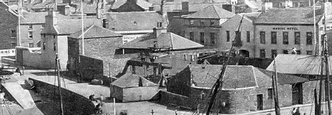
The corner of Crown Street and Shore Road can be seen in John 'Warwick' Smith's "Peel Castle" of 1795
Detail from "Peel Castle" 1795 (courtesy of MNH)
the house in the foreground is I think Munn's house with the pier in the distance.
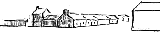
Wattleworth's (#68)
By 1740 David Callister had replaced Kermeen and in 1762 Jo
Callister
According to Goodwin:
this house formerly stood with gable to street, front
door in gable and yard on West side. About 1864 part of the yard
built over, the front of new building looking on street, then the
"Marine" yard was built over and the two houses previously
seperated were joined. The property came into Wattleworths from
the Cowins.
Epitaph in Peel Churchyard:-
James Cowin, joiner, of Peel died 1829 in
74th year. His wife Leonora Wattleworth died 1853 in 85th year.
Jas Cowin held licence 1816 to 1825 possibly
both earlier and later: kept a public house in this house. This
Cowin and old Watterson the schoolmaster were related. the
house passed to the Wattleworths through their grandmother Mrs
Cowin
John Callister m 1726 Leonora Radcliffe
Margaret m. Caesar Wattleworth
Leonora (bapt 29 Sept 1770) m. James Cowin
A James Cowin
first held a licence in 1794 though this could have been the
father as in 1797 the licence holder was noted as James jnr - the
last licence was in 1823; a 'private' licence (to sell alcohol but
not a public house) was taken out in 1825, again in 1830 by Leonora
Cowin , then briefly a public licence in 1834/5 with a final private
licence in 1837 - this must be the public house noted as "Cowin's".
Barracks (#65)
There would appear to be confusion over the position and date for the barracks;
a document published in Journal Manx Museum (unpublished
doc #101) would indicate a building date of 1811 which would correspond
to the arrival of the Royal Veterans
who are noted in the 1814 census of Peel. The Barracks were disposed of in 1815/16
- for some time part was used
as an Independent Chapel and later became cottages. It may be case that
this was also the Caledonian Inn of 1848 - though the 1880 photograph shows
an advertisement for a dining rooms at #66
Caledonian (#66)
A plan of Peel, dated 1848, (in Leece Museeum, on linen though in poor
condition) indicates the 'Caledonian'
Inn at this position, set back a little from the shore road (indicated as
'New Road') and midway between the two groynes.
|
|

|
|
|
|
|
Any comments, errors or omissions
gratefully received The
Editor
©
F.Coakley , 2002
|