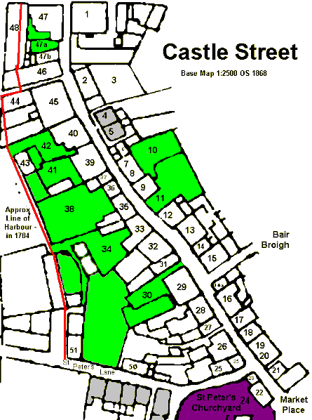
The elevations date from c.1900 - I was given a copy but as yet have not determined the source though I think they are based on information supplied by one of the Goodwin brothers. The base map used is the OS 1868 plan of Peel; the inserted numbers are those used by the author of the text that accompanied elevations. The few blocks marked grey are shown as being devoid of property in Corris's 1784 plan of Peel - this plan was also used to derive the approximate boundary of the harbour before the quay development of the early 19th century onwards.
|
|
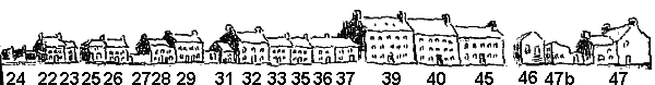
West Side48 - Warehouse St Peter's Lane50 - |
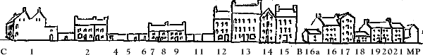
East Side1 - Marine Hotel |
The two groups of buildings at the top of Castle street, {47+48} & {1} both slight the original building line
No #46 is the Courthouse and has been indicated as such in Liber Assed since at least 1706 though indicated as "in the Lord's Hands" since 1616, before this indicated as a house and garden belonging to Edward Apithell since 1575 at the same Lord's rent of 8d (William ab Ithell was Receiver of the Peel c. 1513; Robert ap Ithell is noted as Lord's receiver in 1515 and would appear to have owned land in Lezayre and elsewhere, and the Bithell family continued in Peel for another century. The Ithells were a landed family at Bryn near Wigan; hence the Stanley connection; it would also be likely that they owned a substantial property). A letter from Wm Sacheverell to Lord Derby dated 1 July 1692 [MM Derby Papers MD1719/20] after saying that the country is so poor continues to "entreat your Lordship to give the country an old house you have at Peel which I think is not above thirty shillings a year rent and the country will willingly repair it.". This is quite likely the courthouse thus dating its conversion to around 1693.
In 1714 John Saint was paid for "12 foot and a half of new glass done for our Honbl Lords Court house in Peeltown" the repair of which appears to have been a regular job as for example in 1739 and 1742 John Saint was paid for mending the windows at the Courthouse in Peel but in 1743 he was paid for mending the windows "of the Schoolhouse where the Court was held in Peeltown" - this is probably the period when the Courthouse was rebuilt as 1744 accounts show new timber and 9000 slates for the courthouse roof - James Parr was paid for the nails and Robert Brew for "slating the Court house of Peel one side long 46 ft deep 14 ft [all from CR disbursements]. There is a brief mention in an Oct 1745 report by Gov Lindsay that the high expense in the Receiver's accounts are due to the new court house at Peel and that they are firming the ground (probably the new intacks along the river) . It is likely that the building was enlarged sometime in the early 19th century, Goodwin suggests 1836, with further changes in 1862 when an entrance was created on the newly built quay and the building line of this end of the building aligned with the quay. The adjacent salt warehouse, #48, now demolished, would appear to be of a earlier date date as the facade of the courthouse has had to make allowance for the roofline of the warehouse. One immediate query is why such a high rent for what is even today a relatively small building and which pre 19th century was only about 2/3rd of the size. The much larger property (#45 + #46) on above plan had a total rent for house and garden of only 7d! Possibly it once owned the land to the north, which would have also provided the most convenient location for the ferry boat across to the Castle; once it was in the Lord's Hands the rent was purely nominal and thus possibly it remained at this high rent.
No 45 is one of the three significant buildings in the street; like its neighbours it has at the rear extensive barrel vaulted storage or cellars (though strictly not cellars as they open onto ground level at rear), these cellars run along the length of 39,40 and 45. It was owned by the Coopers - sometime in the early 18th century it was divided into two properties, part owned by the Coopers, the other by Phillip Moore, junr. In 1770 Moore's part was bought to provide a Grammar School which lasted until 1854 after which the property deteriorated until bought by William Johnson
|
|
||
|
|
||
|
Any comments, errors or omissions
gratefully received The
Editor |
||