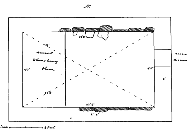
Fig. 45. Keeill Vian, Ballamillgen, Lonan.
[From 4th Report - 1915]
We have learned the former existence of the following Keeills in Lonan, but, only in one instance, at Ballamilgen, are then; now any remains of building.
1. Site of Keeill on the Ouarterland of Ballayolgane, Treen of Hognes (i.e.
Agneash).
2. Keeill Woirrey, on Gretchvooar, Treen of Gretch, or Grettest.
3. Keeill Vael, on Ballarnooar, Treen of Skinscoe. Abbey-lands.
4. Site of Keeill on Ballaquine, Treen of Amogarry.
5. Keeill Vian. Ballamillgen, Treen of Colby.
6. Keeill Vian. Intack, "Treen of Grauff, which gives its name to the Quarterland,
Grawe.
7. Possible Site of Keeill on Ballaleaney, Treen of Brondal.
8. Site of Keeill on Skinscoe. Abbey-lands, Treen of Skinscoe.
9 Keeill Niglus, Ouarterland of Colby, Treen of Colby.
10 Site of Keeill on Ballacoar, Treen of Swarthow.
11. Killkillane, Ouarterland of Ballacannell, Treen of Rauff.
12. The old Church, near Groudle.
O S. VIII 14 (329). A Keeill stood on the north side of the road from Ballayolgane, near the bend where it turns southward to come down into Laxey Glen, at a height above sea-level of 533 ft. This was near the mouth of the Glen Agneash and is still remembered by the name "The old Church" Canon Quine informs us that the Quarterland name is pronouced " Ballakilgane," so that, as in some other instances, the farm would appear to owe its name to the fact that a Keeill had been there ; unfortunately the name of the Saint to whom it was dedicated is now lost.
O.S XI, 2 (1537). At the west side of the road running northwards from the Gretchvooar, about 353 yards N W. of the house, at a height above sea level of about 390ft., the site of this Keeill may still be distinguished and the memory of its dedication is preserved. There are still traces of the enclosure, roughly, circular, reaching across the road and measuring about 25 yards inner diameter. A mound which may be the actual site of the building stands towards its eastern end.
O.S. X1, 2 (1569). The O.S. marks this as "ruins" at the time of the Survey (about 1864), and shows an enclosure, 081, the building being towards its northern side. Ii was finally levelled about 1900 and no trace of it now remains. The site, which is some 460 ft. above sea-level, is 147 yards E. of the old road to Ramsey and about 27 yards N.W. of Ballamooar house. It is interesting as an instance ill which the old Treen name "Skinscoe" is still preserved, notwithstanding the fact that it is Abbey lands, though, as a rule, such names on our Abbey lands have been lost.
O.S. XI, 1 (1055) There is the site of a Keeill with its Burial Ground in a field below Ballaquine house and about 250 yards east of it. This, at a level of about 250 ft., is on the right bank of a streamlet which eventually finds its way into Glen Roy. The O.S. shows the western end of the enclosure as being then traceable ; it is rounded, with a diam. N. and S. of about 50 ft.
O.S. XI, 2 (1578). Owing to the fact that it has long been roofed and used as one of the farm buildings, this has fortunately been preserved and we are able to see at all events the lower portion of the original side walls. The present building measures lbolit 23 ft. by 13 ft., but the west end appears to have been rebuilt and the original length may have been about 26 feet.* The north wall can be traced with certainty for a length of 16 ft., and the south for 14 ft; it is difficult to judge to what height the walls are original but they seem to be so for about 5 ft. They are two feet thick and of stone throughout. The lower portion of the east gable may be original in part but has been broken into for a door way so that there is now no trace of the Altar. The side-walls afford a very good example of the skirting of large slabs of stone set on end which is sometimes met with in our older Keeills. The slight degree of thickness of the walls and the mode of building with stone throughout, show that this does not belong to the oldest period and this is indicated also by the dedication which is our first instance of one to an Evangelist, namely S. Matthew.
As it presents another good example of this peculiar skirting we give a figure
of the side walls from the inside, and here add the measurements of the large
slabs:
North wall, numbering from the broken end at the west,
1, 24 ins, long by 15 ins. high,
2, 24 ins. long by 16 ins. high,
3, 29 ins, by 21 ins. These three are quartz boulders, the rest are slabs
of the local rock ;
4, 24 ins, by 36 ins. and 8 ins, thick,
5, 28 by 20 ins. and 71 ins. thick,
6, 28 by 22 ins, and 4 ins. thick,
7, a boulder about 12 iris. diam, and
8, 15 by 14 ins., and 6 ins. thick
South wall, from the East end ; space from corner of 6 ins.,
1, 48 ins. long by 29 ins. and 7 ins. thick,
2, 42 by 27 ins. and 6¾ ins. thick,
3, white quartz boulder about 25 ins. long and high by 11 ins. thick,
4, 30 ins. long by 27 ins. high and 8 ins. thick.
* The walls are badly bulging and in such a decayed condidition that we were unable to examine the foundations.
Fig. 45. Keeill Vian, Ballamillgen, Lonan.
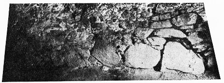
Fig. 46. Stone Skirting, North Wall of Keeill, Ballamilgen, Lonan.
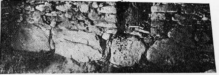
Fig. 47. Stone Skirting, South Wall of Keeill, Ballamilgen.
The enclosure is on a naturally raised plateau about 400 ft. above sea-level. Its bounds can not be clearly traced but would be as shown on the O.S. at which time they would be more distinct, giving an area of ·767. As graves have been sound across the farm road, however, it evidently extended further to the north; the south corner was certainly the natural end of the plateau. Many lintel graves have been met with north and west of the building.
On Balgare, about 660 yards West of the Keeill is a Well with a curious name Chibbyr y Skooie. (? Shadow Well), but it is not now remembered as a Holy or Curative one.
O.S. XI, 2 (1712) On the south side of the Glen Roy, at a distance of about 665 yards S.E. of the last and at a height of some 300 ft., was another Keeill dedicated to Matthew. The O.S. marks the site at the side of a former lane ; a cottage now stands on the spot, which is commemorated by its name Croit, i.e. croft of Keeill Vian.
On the upper farm of this name, which adjoins that of Glen Roy on the north, and about 700 ft. above sea-level there was a Burial ground. It is not marked on the O.S., but would be XI, 1, 1229. A former tenant claimed that the Glen Roy cross-slab probably of the 9th Century (Manx Crosses 49), had originally come from this place. The slab however had been recorded as at Glen Roy so far back as 1841 ; as both farms are on the Treen of Brondal which would certainly have had at least one Keeill on it and as this Christian tombstone must have come from such a Keeill, the site would undoubtedly have been on one or other of the farms, though the particular spot pointed out seemed to be of much greater age and probably a heathen prehistoric burial place. The stone is too large to have been brought from any distance.
O.S., XI, 2, 1784. In the Southern corner of a field on the East side of the old road where it crosses the highroad to descend to Laxey old bridge, is the site of a Keeill of which the name is lost. It has long been ploughed over, but the O.S. show, the boundary of its enclosure at the N. W. then traceable, making the segment about a third of a circle some 40 yards in diameter. It would be about 320 ft. above sea-level.
O. S., XI, 2, (1891). A little to the north of Laxey old bridge on a knoll overlooking the old road and the harbour at a level of about 50 ft., is the site of Keeill Niglus. This is sometimes spoken of as Cashtal Niglus, probably the commanding position having suggested the idea of a Fort.
Below, is the Well known as Chibbyr Niglus which, having been desecrated by bloodshed, was filled up many years ago.
O.S., XI, 5, (2227). A slight mound now marks the site of a Keeill on the south s;de of the road, about a furlong west of Ballacoar house, at a height of 560 ft. or thereabouts.
At Poolvilla, a quarter of a mile to the E. N, E., the O. S. marks a " Cross" by a hedge, but this is not now remembered.
About 660 yards to the N. N. E. of the Keeill, by the side of the old road to Keppel Gate, is S. Patrick's Well, formerly resorted to for sore eyes ; it is possible that this had some connection with the Keeill, which may even have had the same dedication.
O.S., XI, 6, (2512). Behind the old school by the side of the highroad to Douglas, near Ballabeg, is the site of a Keeill and its Burial ground, about 305 ft. above sea-level. Many lintel graves have been found here. When the Electric Tram road was cut through the ground others came to light and the late Dr. Bradbury, of Laxey, remarked that they appeared to have been arranged in triplets. A stream a few yards to the south doubtless derives its name Strooan ny Killane frorn this Keeill, but the dedication is lost. Cinerary Urns are said to have been found when the school was built.
O.S., XI, 14, (3134). The old Parish Church on the road to Groudle must be included here as containing at its west end the foundations of a very early building, about four feet below the present surface. Some of the existing west end walls seem to belong to the 15th century and these foundations may be three or four hundred years earlier. That the site itself and its use as a Christian burial ground is yet older is shown by two of the cross-slabs found here, (Manx Crosses, 8 and 9), which seem to date from the 5th or 6th century, One of these was found by the Rev, Canon Quine, Vicar, in the course of repairs in 1906, at a few feet frorn the foundations at the N.W. corner of the Church. The other is still more primitive and was discovered by Mr, Quine at an ancient Well at the lower corner of the Glebe about 143 yards W, of the Church, The Well itself is triangular in shape and formed in the bed of a running streamlet, of three great blocks of stone set on edge, It is likely that, as suggested by Mr. Quine, it was used for Baptism, representing the transition period from the use of living waters to that of the Font, Probably the cross had originally been set up beside it. Very many lintel graves were found all around the walls of the Church and hundreds of white pebbles from the size of a walnut to that of an egg, The dedication also suggests an early date. The name of Adamnan of Iona, the celebrated biographer of Columba, is known in Ireland and in Scotland to have become shortened in pronunciation into the form Onan,' And, when our Celtic word "Keeill" gave place to the Scandinavian " Kirk,"-its origin having been forgotten, the final letter of the former word was taken over as the initial of some Saint's name, giving us our Kirk Lonan,
|
|
||
| |
||
|
|
||
|
Any comments, errors or omissions gratefully received
The Editor HTML Transcription © F.Coakley , 2006 |
||