Ordnance
SurveyOrdnance
Survey
Ordnance
SurveyOrdnance
SurveyPrior to the national Ordnance Survey, mappings of the British Isles had been done on a county basis; these were on differing scales and although some were good most were inaccurate. In 1762 the Royal Society of Arts offered a premium of £100 for "'an accurate survey of any county upon the scale of one inch to one mile". These county maps could not, however, be merged to produce a national map because of the absence of a common triangulation base (in map making it is possible to go from the general to the specific but not vice versa).
It was following General William Roy's survey of Scotland following the 1745 rebellion that inspired the Board of Ordnance (the body responsible for weapons etc.) to undertake a similar survey of England and Wales. 1784 saw the first stage in this process with the measurement of a four mile baseline on Hounslow Heath (now the site of London's Airport). It was a joint military and civilian venture with Charles Lennox, 3rd Duke of Richmond who, when appointed Major General of Ordnance in 1782, set up a survey office in the Tower of London.
The Ordnance Survey was officially established in 1791 for the
express purpose of making a national map on the scale of One Inch to
One Mile (scale 1:63360). It did its work originally at scales of 2
inches, 3 inches and 6 inches to the mile. Between 1791 and c.1840 it
had covered the south of England and Wales as far north as a line
drawn between Hull and Preston. This work formed the basis of the
first series one inch to a mile Ordnance Survey printed maps. Between
1841 and 1855 the O/S mapped Lancashire, Yorkshire and seven Scottish
counties at the 6" scale. In 1854 the scale of 1:2500 (approximately
25"/mile) was adopted as the standard scale and the older maps were
replaced by new surveys at this scale - completed by 1896 to give, by
reduction, the second series of 1" maps.
Towns were generally mapped at a larger scale with 1:1056 (approx. 5
feet to one mile) becoming the standard though some larger towns were
mapped at 1:500.
The most comprehensive discussion of the O/S mapping of the Island is that by Neely.
The history of the IoM O/S is unique as far as the old series of O/S maps is concerned. Though the Island was incorporated into the national triangulation system pre 1835 (Snaefell & N.Barrule) when retriangulation resumed in 1838 a new station set up on S.Barrule. However there was some dispute between the Island and London as to sharing of costs and the detailed survey work only started in 1864 - the South was finished in 1865 and the North in 1866. The sharing arrangements meant that a reduced cost method of hill sketching at 1"/mile rather than 6" was adopted and that apart from a few sections, the Island was not contoured at either a large or small scale (spot heights appear on map). Apart from Ramsey and Douglas at 1/500 the rest of island was surveyed at 1/2500.
The problem of reducing the 25" and 1/500 to 1"/m was done manually (pantograph) as photoreduction (in use from 1853) would make the map too fussy with details. The hill shading was actually done at this 1" scale. Maps were printed from duplicate plates, 'electrotypes', leaving original plates in perfect condition. The Outline version was produced first and then duplicates taken, after which hill shading was added to original plate.
These O/S maps quickly became the base from which all future maps of the Island derived, though the Philips and Standford maps originating in the 1850's and 60's lasted well into the next century.
The index sheet shows the coverage areas of the original 25" and 6" series - each 6" map (labelled I-XIX though shown as 1-19 on index) can be considered as split into 16 rectangular areas numbered 1-16 starting at the top-right or NorthWest corner. These areas correspond to the coverage of the 25" plans though those covering merely sea were of course not printed and some consisting of land margins were printed as insets on adjacent sheets. Each 25" plan covered an area of 2.5 x 1.5 km. Some of these are are available on CD_Rom.
An index to the place names found on the 6" and 25" series is available.
The index map can be approximately linked to the O/S Grid coordinates as the South West corner of sheet O/S VI/13 (should it exist) would correspond to SC200850 and its North East corner corresponds to SC225865 - however some small errors would exist as the projection origin was altered from the old mapping to the modern scheme.
The 1896 revision of the 6" maps was photoreduced to give the first edition of 1:25000 2-sheet Public Rights of Way and Outdoor Leisure map published by IoM Dept of Local Government. later editions have used the new digital maps, which though more readable, do not show the now historical information (eg location of chapels,mills &c) found in the old 6" series.
Although the 1" map is too big to put on a standard 27"x18" sheet, the O/S IoM map has always been printed on a single, oversize sheet. A complication with numbering of sheets occurred, as in 1873 the O/S decided to renumber most of N.England sheets (which often existed in dual numbers with few other changes to plate). The new sheet numbers for Sheet 100 were 36,45/6,56/7 though none of these individual sheets have every been found as the IoM map continued to be printed from a single plate. The sheet number 100 (though appearing in indices) was not engraved on any of the early states - however junction lines for the putative sheets were engraved on the inside edges
The 'new series' included the newly surveyed Northern areas and the revised mappings of the Southern counties which had appeared in the first or 'old series'; note the IoM never appeared as an old series map.
These maps were issued in two forms - a 'hills' edition in which the hills and slopes were indicated by hatching (this
tended to produce a rather black map for the Island in which it was difficult to see details on the higher ground) and an
'outline' edition in which the hatching was not present thus giving a much clearer map. The sheet had the characteristic
form of Old Series maps for N.England with redesigned border, spot heights and parish boundaries (names in small capitals).
The first edition included the railway Douglas to Peel (which was differently engraved than on the Hills and Outline Editions)
In 1882 a new edition with amended title Isle of Man 1882
(formerly 100) SHEETS 36,45,46,56,57 appeared with railways
brought up to date.
According to Harley there appeared to be a full scale national revision of New Series between 1893-98 with all sheets issued by 1899. Popular (3rd ed. sheet) quotes a revision date for IoM of 1896.
|
|
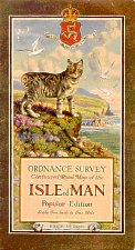
The 3rd edition sheet 17 was issued in 1903 and was revised at intervals. Title "ORDNANCE SURVEY OF ENGLAND(Third Edition)"(Large Sheet Series) SHEET 17 Had a reference grid A-M vertically and 1-11 horizontally. The revised 3rd edition was issued in 1920 and the Popular edition with its attractive Manx Cat cover issued in 1921 |
TBC...
G.J.H.Neely The Ordnance Survey of the Isle of Man
Proc IoMN.H.&A.Soc III #4
pp388/404 1930
R.Oliver Ordnance Survey maps: a concise guide for historians
London:Charles Close Society 1993
T.Owen and E.Pilbeam Ordnance Survey, map makers to Britain since
1791 Southamptom: Ordnance Survey + London:HMSO 1992
W.A.Seymour A History of the Ordnance SurveyFolkstone:Wm
Dawson & Sons 1980 [ISBN 0-7129-0979-6]
|
|
||
|
|
||
|
Any comments, errors or omissions
gratefully received The
Editor |
||