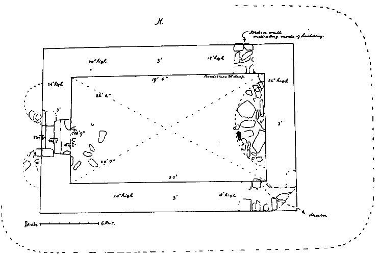
Fig. 40. Plan of Keeill Chiggyrt, Maughold.
[From 4th Report - 1915]
[Keeils other than in the churchyard]
A few years ago lintel graves were discovered in digging drains for a new house at Port-y-Vullin. This was close to the brooghs on the West side of the Port about 70 yards north of the highroad and 130 yards west of the stream, about 55 ft. above sea-level. This would be O.S., V, 15, (388). One about 3 ft. 6 ins. below the surface, lying E. and W., measured 6 ft, 9 ins. by 2 ft. The sides were lined and the top covered by thin flags ; evidently they were Christian graves and, almost certainly, mark the site of a keeill of which no other trace remains.
A Keeill formerly stood on the E. side of Port-y-Vullen, by the road leading to Gob Ago, where there is now a cottage, at a height above sea-level of about 90 ft. This would he O.S V, 16, 674. Mr. Cowin and others from the neighbourhood remembered seeing lintel graves here disclosed by the plough ; and, that it was in use early in the ninth century is evidenced by the large cross-slab, (Manx Crosses, 48) which it appears had been taken from this cemetery, and, for many years, set on the hedge by the highroad but is now placed in the collection at the Parish Church.
O. S. V, 15 (615). There was a keeill on the Quarterland of Ballagilley on the Treen of the same name. The site is in a field about 167 yards West of the highroad to Douglas and north of the old Hibernian Inn, at a height above sea-level of about 570 ft. Lintel graves have been found here and it is remembered how a former owner named Lowey removed the last of the walls, and never prospered after. In this graveyard was found the fragment, of a Scandir avian cross-slab, (Manx Crosses, 106), with well carved figure of a Boar and traces of runes It must originally have been a larger slab, but, though diligent search has been made, no further portion of it has been recovered.
O. S., V, 11 (133), is pleasantly situated under the hill overlooking the Town of Ramsey on the S.E. In the Manx Society, Vol. XXIX, the Editor says it is dedicated to S. Catherine but gives no authority. Like some of our Parish Churches this occupies the site of an ancient keeill and, though enlarged and frequently repaired, has probably been in continuous use from very early times, thus affording an interesting link with the past. The surrounding graveyard, at a height above sea-level of 76 ft. standing at a higher level than the field in which it is, appears not to have been enlarged; it is now walled in and roughly 37 yards square. There is a record of this Church having been re-built during the episcopate of Bishop Parr in 1640 ; a hundred years later it was re-built and consecrated afresh by Bishop Wilson, 1747, and, in 1850, was again thoroughly repaired and restored. Feltham, in 1798, gives its dimensions as 61 ft. by 19 ft. which are the proportions followed in our older Parish Churches. All trace of the older buildings is now lost, but, it has been suggested that the Scandinavian fragment displaying scenes from the story of Sigurd and the dragon Fafni, (Manx Crosses, 96), which for a long time had been in use as a lintel at a house in Maughold street, Ramsey, had probably been brought from this Burial ground.
In the low meadow bordering the north of the adjoining Quarterland of Ballacowle, about mile north-west of the Church, O.S., V, to, (t6), is a spring noted for the excellent quality and never-failing supply of its water. The dedication, as shown by its name Chibbyr-y-Woirrey, marks it as a Holy Well, though there is now no use or other remembrance of it as such.
O.S. VIII, 9 (1387). This name was remembered by Mr. Murray, Crowcreen, and others ; it may have been derived from that of a former owner or occupier. The supposed site of a Keeill, 467 yards north of the house on Ballajora, at a height above sea-level of 390 ft. or thereabouts, looks very like the remains of a Cronk or tumulus of prehistoric age, and the cist which has been exposed in it seems to point to a Bronze-age burial. The mound is about 30 ft. diam., the cist, of rather thin slabs, about 3 ft: by 2 ft. 6 ins. and 2 ft. or more deep. But Mr. Lowey described to us his discovery in the little field to the East of this at a height of about 400 ft above sea-level, -' narrow grave, flagged above and below and at the sides'. This answers to a Christian lintel grave and it seems more likely that it may mark the actual site of the Keeill, of which there are now no remains. It is not marked on the O.S. but would be VIII, 3, (1090).
There was a Keeill close to the mill-dam about 200 yards north-west of the house and 370 yards E. of the highroad about 500 ft. above sea level. No trace of it now remains, but a Cross-slab of about the seventh century (Manx Crosses, 33), was found here which suggests the period when it was in use. It does not appear on the O. S. but would be VIII, 3 (1107),
O.S. VIII, 3 (1210). On the same Treen as the last, 117 yards W. of the highroad and at a height above sea-level of some 460 ft., one wall of a Keeill remains now forming part of the boundary of the haggard a little to the rear of the house. It measures about 18 ft, long by 4 ft. high and 2 ft. 6 ins. wide, and is built of stone throughout; Mr. Callow allowed us to excavate inside but no foundations or further trace of it was discovered. Many lintel graves have been found in the enclosure, the bounds of which cannot now be traced. A stone which may have been a Font is kept in the haggard. It is rudely made from a boulder of the local rock, the bottom dressed flat, the sides very slightly dressed to shape, and measures 18 to 20 ins. diam. by 7½ ins. high ; the basin, with inclined sides, is 13 ins. diam. and 4 ins. deep. Near by is a Well known as Chibbyr lieh laa, or, Chibbyr Malaa.
On the Intack lands of Magher Breck, in a corner of a field by the north-west side of the road which leads across from Ballajora to Crowcreen, lintel-graves have been turned up by the plough, and it is still remembered as the site of a keeill, called after a natural rise in the ground, Keeill Cronk y Noe. It is not marked on the O.S., but would be VIII, 4 (1467), at a height above sea-level of 465 ft. or thereabouts,
Immediately over the boundary hedge to the S. W. of this is the little plot of ground on Ballafayle known as Rhullic y Quakeryn. O.S. VIII, 4 (1503). This is a rough uncultivated piece of ground which, about 1672, was fenced off and set aside as a cemetery by William Callow, one of the best known of Manx Quakers. There appears to have been a cottage on the unfenced rough land the other side of the road about one hundred years ago, but it is unlikely that there ever was a keeill here or that there had been burials before it was made use of by the Quakers. The place has been well described in The Friends' Quarterly Examiner, Oct. 1908, --"Rhullick ny Quakeryn : Notes on the History of Friends in the Isle of Man." By Thomas Hodgkin, D.C.L.
The site of a keeill is remembered on Ballafayle y Kerruish, which property is given in Wood's Atlas as a part of the Barony of S. Bees. This is in a small field or croft on the southern margin of Port Mooar, now called Keeill Croit ny Howe. All traces of it have disappeared. It is not marked on the O.S, but would be VIII, 4, (1524), at a level above the sea of about 230 ft.
O.S. VIII, 4 1536. On the adjoining Quarterland of Ballafayle y Cannell, at a distapce S.W. of the last of about 630 yards, are the remains known as Keeill Chiggyrt There is a local tradition that the 'priests were buried here', 'the common people' at Ballajora. Whether this orginated in or is derived from the name it is impossible to say, but it supports the view that the present name is a corruption of 'Saggart'. It has also been called Keeill Casherick,--the holy Keeill-a name which has got on to the O S., but appears not to be known locally.
The Keeill measures about 20ft. by 11ft. The walls now from 18 to 24ins. high, are well built, without lime mortar, of stone throughout and are of even thickness ; the stones are unhewn and undressed but selected and well-fitting, averaging from 14 to 15 ins. long by 4 ins. thick ; some of the foundation stones are larger and reach to 12 ins. in thickness. Outside also are many larger flags built in random courses. Towards the E. end, the north wall was found to have its foundations 2 ft. below the floor, the cavity being filled in with rubble: The S. E. corner had been stripped almost to the lowest course, and showed remains of a drain; one of the paving stones passing partly through the wall gives the original level of the floor. The doorway, not quite i n the middle of the West wall, is built of flags in courses and shows inside, a rebate of 6 ins. from which it is splayed inwards. No distinct sill remains but there was a step of about 8 ins, below the level of the ground, and two flagged steps each
about 4 ins. high, the width being from 3 ft. 8 ins. inside to 2 ft. 4 ins. outside. Some rather larger stones curving outwards from either side of the entrance appeared to be in situ and reminded one of the well-built curved entrance to the Keeill at Ballahimmon, German. The Altar itself has gone but there remains the foundation of an almost semi-circular dais or platform on which it stood, measuring 8 ft. 6 ins. long by 3 ft. wide, only one stone on edge is now in position ; it is io ins. high and may mark the S. W. corner of the altar.
The floor shows remains of small paving stones of all shapes, averaging about 12 ins. by 7 ins. and has a slight fall from the E. to the W. end, but there were signs of disturbance as of former digging about the middle. The customary bank is clearly seen, 8 ft. wide against the East end and 4 ft. at the South side. There vas same slight indication of the E. window but the jambs are now gone. Mr. Kerruish remembers the walls standing about 5 ft. high and Mrs. Callow has recollection of recesses in the walls which, as children, they thought were cupboards, but no doubt they were windows.
Fig. 40. Plan of Keeill Chiggyrt, Maughold.
The enclosure can still be faintly traced and is well defined on the O.S. made when the fence was in existence ; it measured about 38 yards N. E. and S. W. by 22 yards S. E. and N. W., the Keeill standing toward the S. E. the aspect is S. E. Within the enclosure was found the Anglian cross-slab of about the 8th Century, (Manx Crosses, 51), now set up with the rest from this parish at Maughold Church. About 50 white pebbles, from 12 to 32 ins. long, were found in the Keeill, and two which were larger.
By the dub called the 'Ring dow,' about i5o yards N. of the Keeill and 192 yards E. of the house, is the Well known as Chibbyr y Woirrey, the name of which suggests the possible dedication of the Keeill. This would be on the O.S., VIII, 4 1592.
O.S., VIII, 6, 1592. On the south, slope of Barrule between 800 and 85o ft. above sea-level are the remains of Keeill Woirrey. These are about 470 yards W.S.W. of the Corna farm house, 15o yards S.S.E. of Park Llewellyn road, and 290 yards N. of the miners' road, and almost opposite a little stream coming down the steep slope of Slieau Lheam. Being on land still uncultivated, near the head of the little valley closed in by the winding of the hills, this, like the Lag ny Keeillee in Patrick, gives a good idea of the lonely character and moorland surroundings of our keeills when first they were used.
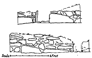
Fig. 41. View of South and West walls, Keeill Woirrey, Corna.
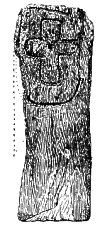
Fig. 42. Cross Slab from Keeill Woirrey, Corna.
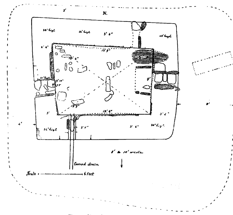
Fig. 43. Plan of Keeill Woirrey, Corna, Maughold.
It measures about 13 ft. 6 ins. by 9 ft. 6 ins. The walls, now from 2 to 4ft. high, have bulged through settlement and it will be in part a consequence of this that the southern one measures quite 12 ins. shorter than the northern, while the eastern one is about as much less than the western. They are about 3 ft. 6 ins. wide excepting the west which does not exceed 3 ft., and are rudely built with a rubble core faced inside and out with rather ill-assorted stones unhewn and undressed. Some of these at the foundation measure from 3 to 4 ft. long by 9 to 18in. high and 2 to 5 ins. thick, but for the most part they are small. The foundations were found to be but a few inches below the floor-level. The south and west walls have a skirting of slabs on edge and one or two remain in the north wall. The doorway a little south of the middle of the west wall is 22 ins. wide inside to 26 ins. outside. The lower stones of the jambs are set on edge ; on the south is one 29 ins. long by 8 ins. high and 2 ins. thick: on this rested a heavy stone laid flat, and above it must have been built in courses; on the north one 19ins. long by 12 ins. high, either side of which is occupied by the 5 ins. end of a large stone on its edge in the face of the wall. The space between the jambs is flagged and has a step of 3 ins. to the interior. There is no socket and as the flags do not allow of one it is possible that the narrow doorway in this instance was closed when required by a ' scraa' or bundle of sallies, such as was in use for houses in remote country districts until quite recent times. This was made the full width of the doorway which narrowed inwards so that it should fit tightly. The sallies were held together by bands with a stouter band round the middle, made of heather. A stick twisted in this band would catch the wall at either side and so hold it fast. The top would be cut off straight at the height of the door lintel. The East kvindow 15 ins. to 18 ins. wide with a slight fall outwards, has the sill which has settled back a few inches, 39 ins. above the floor ; it shows a north jamb stone about ao ins. long with an outer one 21 ins. by 7 ins. and 4 ins. high. The south jamb is represented by a quartz boulder, 32 ins. long by 8 ins. and 12 ins. high. In the north wall, at a point 24 ins. from the East corner, one jamb-stone remains at a height above the floor of 33 ins. ; this is 2o ins long by 26 ins. high and 3 to 4 ins. thick. There is an outer jamb of white quartz, 14 ins. by 7 ins. high, and about 8 ins. wide, and the outer sill-stone, 17 ins. by 12 ins., is still in position showing a slight fall to carry off the rain. Some stones of the floor pavement remain, an average of 14 measured reins. by 6yins. ; from the middle, eastwards, there had evidently been some excavations. The Altar measured 48 ins. along the gable to 44 ins. at the front, The north side consists of a slab 24 ins. long by 3 ins. and 12 ins. high ; the south side has a slab 16 ins. by 3 and 5 ins. high, with a small stone at the outer end ; nothing else of it remained except about 6 ins. of earth and small stones. At the west end of the south wall, a built opening like a window only that it was on the level of the floor, suggests an explanation of what looked like a second door in the Keeill at l,allahimmon. It was 14 ins. wide inside to 12 ins, outside, the walls on each side carefully faced ; it was flagged, and beneath this flooring was a well-formed drain, 6 ins. wide, of stories on edge continued for four ft. to the face of the bank outside.
An excavation made between the Altar and the north wall of the Keeill revealed at a level of 12 ins. below the floor, an earlier pavement extending to about 3 ft. from the East end, with a width of about 2 ft. 6 ins. Resting on this platform as though crushed down from its original level, was a heavy stone 3o ins. by 24 and 4 ins. thick, which passed for 2 ft. under the wall. Between it and the platform, as well as beyond it, at points about twelve inches apart, were charcoal, crumbs of pottery and a chip of red flint; and it was probably a burial of Bronze age.
The Enclosure, not marked on the O.S., can still be traced though not defined on the south where it crosses boggy- land. It has a S. F.. aspect and has been raised to a level for the Keeill to stand on. It treasures about 42 yards E. and W. by 30 yards N. and S. and was enclosed by a fence of sods strengthened v-ith stone. Just outside on the East and on the West it is drained by a slight natural hollow, but on the South it sinks into a rushy bog, and when the Keeill was erected the situation must have been very damp. The walls of the Keeill are, as usual, protected by embankments of earth with stones, which evidentlv reached to the level of the window-sills and on the East and South were from 8 to 10 ft. wide. The Eastern one is flagged on the top with great stones, and there has been a rough pavement from the door round the S. W. corner.
Only seven white pebbles were met with in the Keeill ; outside are many graves almost all with headstones venerable in their extreme simplicity, consisting merely of large unhewn stones from the mountain side set on end. Some had stones at the foot also and some at each corner. None of these stones showed carving or dressing of any description. One grave under the bank against the E. gable and set at an angle, was flagged above and below and at the sides, and measured 5 ft. 6 ins. by 2 ft ; another towards the N. W., with an upright stone at each of its four corners, proved to be a lintel grave only 3 ft. long. No loose article or remains were found in anv.
Loose among the rubbish near the altar lay, on its face, a rough slab 42 ins. by 16 ins. and from 2 to 3 ins. thick. Fig. 42. This was found to have a plain linear cross incised on one face and contained within an oval ring. This may date from the sixth or seventh century and have been contemporary with another, (Manx Crosses, 18), which has been found here. It bears some resemblance to the slab from Maughold Churchyard, (Manx Crosses, 20). From this Keeill also came the interesting slab, notatombstone, (Manx Crosses, 114), which bears the Inscripton in runes of late 12th or early 13th Centurv,-' Christ Malachi Patrick and Adamnan. But of all the sheep is John the Priest in Cornadale.'
On the Quarterland of Ballachrink, Treen of Cornaa. is the site of a keeill lonz since ploughed over. This is on the Ard, the high land between the streams of Ballaglass and Rhenab, at a point 45 ~-ds north of the road and 40 yds. east of the field hedge, being a little to the south of the interesting monument known locally as the Cashtal, at a level above the sea of some 490 ft The field is still called ' Bwoaillee Caballagh' Chapel-fold. This is not marked on the O.S., but would be VIII, 7 (1012).
On Ballashelaige, part of the Quarterland of Ballacorteen, Treen of Corna, is the site of yet another Keeill, known locally as "the old Church." A cottage now stands here and in the garden overlooking the stream at a height of about 490 ft. from sea-level, many lintel graves have been found. This is not marked on the O.S., but would be VIII, 7, (2206).
On Intack lands on the Eastern slope of Sheau Ruy, at a height of about 790 ft., there appears to have been a Keeill long since removed. From this site in 1894, was brought the cross-slab of 7th or 8th century, (Manx Crosses 32), now in the collection at the Parish Church. The site would be O.S., V1I1, 11, (2273).
O.S., VIII, II, (2347). On the summit of the Barony. overlooking the Dhoon Glen, at a height of about 65o ft. are the remains of Keeill Vail, Church of Michael. The Abbey Rent Roll mentions Keeill Vail as appurtenant along with S. Maughold's, to Furness Abbey in the 13th century. The Rectory of S. Michael and Mahold (from the Farmer whereof, is due the yearly rent of ;66 13s. 4d.) is in the Isle of Man. Bishop Marc, in 1299, confirms 'appropriationem Ecclesiarum Sanctorum Michaelis et Michaldi in Mannia nostre dyocesis Abbati et Monachis de Furnesio' ..Oliver Monumenta Vol. 11, Manx Society, Vol. VII, p. 133. And that this is the Church of S. Michael referred to is shown by the Confirmatio Ecclesiarum et Terrarum, 1505. by Thomas, Earl Derby, Lord of Mann and the Isles 'Terras etiam ecclesiae ...sancti Magholdi et sancti Michaelis adjacentis...Olivcr Manx Society, Vol. IX, p. 29 The same volume at p. 36, quotes from Furness Abbey,-Certificate of Revenues by the Commissioners, 1537... 'Also there ys apropryate to the said late Monastarv the personages of Seynt Mahold and Seynt Mighell within the said Yle, which ben letten to fferme and the Curate ffounde for the yerely rent of £6 13s. 4d.'
From the appearance of what little still remains there can be no doubt that this was one of our early Keeills. It must have measured about 20 ft. by 11 ft. The East wall remains only 24 ins. high, consisting of four to five courses of small slaty, surface stones, the largest is 24 ins. by 18 ins. and 3 ins. thick, and there are one or two about 18 ins long ; the wall is 4 ft. wide, faced outside and in, with the middle space packed with soil and rubble. The south wall, 3 ft. wide, remains for 13 ft. from the East end, with two or three courses of stone ; west of that point, all the material found suitable for building has been removed, but, some of the loose stones of the packing indicate its extension, the original length of which seems also to be marked by the rough floor-pavement still remaining. The West end is entirely gone but its position is indicated by the straight line ip_ which the pavement ends ; about the middle of it is an extension of this pavement for a width of two feet which evidently marks the position of the doorway. Of the north wall, only four to five feet from the East corner now remains, which at the Eastern end is 2 ft. 6 in. wide, with five or six courses giving a height of 22 ins. There is no trace of the Altar. The floor, paved with rough stones irregular in size and shape has a slight gradual fall from East to West. In testing for the S.W. corner we came across two lintel graves side by side, having their sides and ends lined with thin slabs and the bottom partly so, and covered by flags which had been crushed in. They measured 6 ft. by 13 to 18 ins. wide and 1 2 ins. deep, the tops of the cover slabs being 12 ins. below the floor. Nothing was found in them but a little black unctuous soil and a very little wood charcoal. The covering stones had been crushed in and it rather looked as though the one nearest the wall had had a second burial on top of it, but this might be due to the floor sinking. Mr. Harrison had previously noted a small grave at the N. wall. About four dozen white shore pebbles were met with, (two or three coloured), a few in the grave, the rest scattered in the rubbish ; about a dozen larger (5 ins. by 3 ins). were noticed.
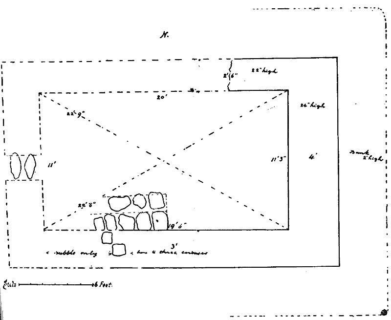
Fig. 44. Plan of Keeill Vail, Barony, Maughold.
The customary embankment against the walls is seen at the E. end about 2 ft. high and four feet wide ; this was formed of good sized stones thrown in anyway and packed with a little soil, so that it is difficult to see where the wall ends and the bank begins. The bank is shewn along the North and South walls for about 9 or 10 ft. from the Eastern end.
The boundary line of the surrounding cemetery is quite clear on the North and West and can be traced, though not easily, round the East and South. It measures about 45 by 50 yards, the Keeill being set towards the N. W. Within the enclosure at its north west end is one of the many tumuli here assembled in small compass. This, which measured about 30 ft. dram., was foun:l to contain near its centre a well-formed, stone-lined grave packed around with small surface stones ; a ring of larger stones surrounded this ; the capstone was gone. This rubble was covered by large slabs which had more small rubble over them, and, above this, yet another covering of large stones, many of which appear at the surface.
About 200 yards North of the Keeill is Loughan Keeill Vael, or, the lagagh, a bare patch in the heath, which for the greater part of the year lies under water. On the Eastern slope of the Hough, about a quarter of a mile away, is the little dripping Well, Chibbyr y Vashtee or " Christening Well " as it is still called, which is never dry. Its name may be due to its use when the Keeill was built, the memory of it having been handed down by tradition from generation to generation.
|
|
||
| |
||
|
|
||
| Any comments, errors
or omissions gratefully received The
Editor HTML Transcription © F.Coakley , 2006 |
||