J & C Walker (fl 1820-95) engravers draughtsmen and publishers, 47 Bernard St Russel Sq (1830), 3 Burleigh St Strand (1837), 9 Castle St Holborn (1841-7) and 37 Castle St Holborn (1875) - they published several maps of IoM during the 1830's
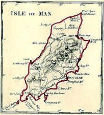
This small map, with a clear square shouldered shape showing main roads + indication of hills appeared in several guises
States:
(i) England 1 - IoM inset in top lh corner
SDUK - Society for Diffusion of Useful Knowledge - issued series of maps of World originally in parts by Baldwin and Cradock 1829-32;then by Chapman & Hall 1844; C.Knight 1844-52; G.Cox 1852-3; Stanford 1857-70
Main map very messy and too detailed - I.O.M appeared as square inset top lh 2.5" x 2".
Baldwin and Cradock publishers 47 Paternoster Row; later Baldwin, Cradock & Joy
Feb 1831 Baldwin and Cradock Paternoster Row London pub under superintendence of Society for Diffusion of Useful Knowledge
(ii) Isle of Man
Transfer from inset IoM map in “England 1” map of Northern England.
Charles Knight was associated with SDUK from its start and owned the S.D.U.K. plates in 1850.
Charles Knight & Co Publishers London - originally 22 LudgateStreet and later 90 Fleet Street
small square bordered map to left of “Cumberland and Westmoreland”
Below map (Ce) scale "Statute Miles 69.1 - One Degree 10+30" ; below scale imprint “London Charles Knight. 90 Fleet Street”
History:
The Imperial Cyclopædia. Cyclopædia of Geography (issued May 1850)
London Charles Knight 1850Work also apparently issued in weekly parts (cf advertisement in volume) and in 16 parts completed 1853
The Imperial Cyclopædia. Cyclopædia of Geography Vol 1
London Charles Knight (1852)E.Burden distinguishes a further 2 states of transfers for Berks based on updates to Railway - IoM probably unaltered though adjoining Cumberland map may have been updated.
The Imperial Cyclopædia. Cyclopædia of Geography Vol 1
London Charles Knight (c1853)
The following maps appear to be based on the 1831 Map drawn by Creighton and used in Lewis's Topological Dictionary.
100 mm x 153mm (1:311,000) Similar to Creighton; N to Top; Hill masses indicated by hachures; most named - Snawfel
Names: Port Erin, Port le Mary, Kirk Ouchan (sic)
Ee(os):”Drawn and engraved by J & C.Walker”
Aa:title
imprint 'published by J.W.Parker West Strand London May 17 1836'
to face p181 of Lord Teignmouth Sketches of the Coasts and Islands of Scotland and of the Isle of Man descriptive of the scenery and illustrative of the progressive revolution in the ecconomical, moral and social condition of the inhabitants of those regions in 2 vols vol 2 London John W.Parker, West Strand M.DCCC.XXXVI
Included in:
Sir George Head A Home Tour through
various parts of the United Kingdom being a continuation of the “Home Tour
through the manufacturing Districts” also Memoirs of an Assistant Commissary-General
London: John Murray, Albemarle Street. MDCCCXXXVII. 1837
|
|
||
|
|
||
|
Any comments, errors or omissions
gratefully received The
Editor |
||