 Cary 1827Cary 1827
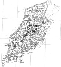
IoM - composite image from sheets 46 + 51
A complete map of England and Wales published by John Cary between 1820 and 1830. In 1832 the sixty-five sheets were reissued
by G. and J. Cary in a volume entitled:
"Cary's improved map of England and Wales, with a considerable portion of Scotland, planned upon a scale of two statute
miles to one inch, drawn from the most authentic surveys & parliamentary documents."
Like those of Cary's county maps, the plates passed first to G.F. Cruchley; by the 1860s they were in the hands of Gall
and Inglis. IoM is covered by plate 46 & 51.
Plates in the 1832 edition have the imprint
PUBLISHED BY G. AND J. CARY, 86 ST JAMES'S STREET,FEBRUARY 1st.1832 (Ce OS).
When reissued by Cruchley in 1856-7 this was altered to LONDON. PUBLlSHED BY G. F. CRUCHLEY MAP-SELLER & GLOBE MAKER,
81 FLEET STREET.
on 2 sheets North (Peel) 51 + South (St Johns-ClayHd) 46
Similar format each sheet..
Grid 10' Lat & Long
Aa(os)'Continuation North _ Sheet ..'
Ca(os)scale
Ea(os)'Continuation North _ Sheet ..' No...
Ec(os) up-page 'Continuation East _ Sheet ..'
Ae(os)'Continuation South _ Sheet ..'
Ce(os)Imprint
Ee(os)'Continuation South _ Sheet ..'
(i)1827
(ii)1832 Imprint 'LONDON:PUBLISHED BY G&J.CARY,86 St.JAME'S STREET, FEBRUARY 1st.1832'
(iii)1854 Imprint 'London Published by G.F.Crutchley'
Based strongly on Smythe 1826 but with some additional maritime information from probably Mackenzie - the two plates were engraved seperately and overlap by about 1mile on the map; the names do not perfectly align across the border - I have merged across the 5 mile square line running from Ballacosnahan in Kk Patrick to Clay Head on east coast. Somewhat clearer than Smythe and as on two smaller sheets, more convenient to use.
Cary's improved map of England and Wales, with a considerable portion of Scotland, planned upon a scale of two statute
miles to one inch, drawn from the most authentic surveys & parliamentary documents.
LONDON:PUBLISHED BY G & J.CARY,86St.JAME'S STREET,FEBRUARY 1st1832
Crutchley's Reduced Ordnance Map of England & Wales Planned on a scale of two miles to the inch, and engraved on sixty-five
Sheets [1857]
[advertised as half the scale and half the price - 1s plain, 18d coloured]
|
|
||
|
|
||
|
Any comments, errors or omissions
gratefully received The
Editor |
||