 Murdock Mackenzie 1775Murdock Mackenzie 1775
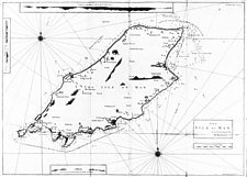
Chart XII. The Isle of Man 580mm x 985mm
Surveyed and Navigated by M Mackenzie Sn, commissioned by Admiralty.
Original and more accurate shape for island though little topological detail; hills shown in outline from sea.
Title + scale (Eng Miles 6) in plain rectangular frame
From A Maritime Survey of Ireland and the West of Great Britain .. Vol II containing the survey of the West Coast of Great Britain,from Bristol Channel to Cape Wrath: London
|
|
||
|
|
||
|
|
||
|
Any comments, errors or omissions gratefully received
The Editor © F.Coakley , 2010 |
||