[J Manx Museum vol III #49 pp144/153 - 1936]
Thursday, 17th September, 1936.
The party- was divided into two main sections (a) Archaeology and (b) Geology and biology.
From the Museum the party proceeded to the Braaid Megalithic Circle. Here Professor Fleure took charge and drew the attention of the visitors to the central position of the Island in the Irish Sea and to its profusion. of megaliths of several different types. That at the Braaid he described as a sub-megalithic circle, with accompanying alignments of small standing stones bounding the two faces of long mounds kept up by dry walling. Between the long mounds some small occupation places were noted. Absence of finds made dating rather difficult, but a late rather than an early date seemed lit:ely, he thought. The work of excavating and examination so far as it had gone had been effected under his supervision and largely by his assistants, Mr. Elwyn Davies and Miss Dunlop, helped by a party of students from the University of Manchester, which is collaborating with the Trustees in archæological work in the Island.
The party then drove to Ronaldsway, where excavations had been proceeding for the last two summers under the supervision of Mr. G. J. H. Neely, Inspector of Ancient Monuments for the Isle of Man, and who took up the tale of discovery. The site is situated on the eastern edge of the Ronaldsway Aerodrome, which the airport authorities proceeded to level early in 1935, obtaining soil for this purpose from certain small rises fringing the area.
While these operations were in progress, ancient graves were uncovered on the south side of the aerodrome, and near these were found a number of smelting pits. Investigations were proceeding when a large body of workmen started to remove soil from the site of the old burial ground on the cast side. It was necessary for observation to be kept on these operations, which disclosed lintel graves and many finds of archeological interest, including a very fine jet armlet, many bone pins and pieces of pot. The contractors, Messrs. McKibbin and Kewley, readily agreed to withdraw their men from this area to allow investigation on behalf of the Trustees.
A few days later two large tombs were found. These have the appearance of large cists or chambers, composed of slabs on edge. The bodies, however, in both cases, had been placed in lintel graves, five feet below the chamber.
The slate slabs forming the sides of the southern chamber are remarkable; there being no slate rock in the immediate neighbourhood excepting odd pieces in the drift, they appear to have been brought from a considerable distance.
At the west end of the northernmost chamber was found, firmly wedged on edge between two upright stones, a fine limestone cross-slab of circa 8th, or 9th, century (now in the Manx Museum). In one corner of the slab are three Tau crosses - an apparently unique feature. These two large graves were completely covered over by the greatest number of white pebbles ever associated with any burials on this Island. These have now been replaced on the graves.
North of this area the end of a stone platform, eight to ten feet in width and perhaps fifty feet in length, was found. This seemed to be of earlier construction than the large graves themselves; but, while this may be so, a later examination showed that the platform itself covered a number of lintel graves which appear to be of an early Christian type. Paved footways led to the platform from the area to the west, but only one of these features has survived. The others, together with many associated pavements, were broken up by a subsequent people, and the material used for the construction of pits similar to those found in the south of the aerodrome, in which smelting operations had been carried out. Much iron-slag and charcoal were recovered from these smelting places. There is a tradition in Ireland that working in metals was considered unlucky, and that some measure of purification was obtained by carrying out this work in the precincts of a burial ground.
Near the eastern portion of the platform many skeletal remains were found, one on top of another and crossing at all angles. These may be the remains of soldiers who fell at the Battle of Ronaldsway (A.D. 1270), when this burial ground was probably held as a strong point. Remains of iron weapons. were found among the bones.
The southern part of the site yielded a midden containing a very large quantity of broken pot among shellfish and other refuse; while, further west, the circular stone bases of several huts were uncovered. Protecting the western flank of this small collection of huts, there was found a sunken stone wall, having a ditch of about. twelve feet in width on the outer side.
A slight excavation on the north side of the site disclosed the base of a rectangular building of about twelve by eighteen feet - much damaged apparently by the contractors' operations. From this point, along the northern and eastern edges of the site, were the remains of pavements, much of which had apparently been broken up and converted into smelting furnaces.
What appears to be an underground passage, or Souterain, was found on the northern edge of the excavation.
A number of worked flints were found on every part of the site. Some of these appear to be of Neolithic, or even Mesolithic, type; but they are not sufficiently numerous to assume occupation at these remote periods, and may have been brought here in later times. At present, occupation seems to be more certain during the later Bronze Age. The smaller circular but bases may be associated with the people who buried their dead in the earlier lintel graves. These are inclined slightly south of east, While the later graves have a truer orientation. Inside the rectangular base of the building mentioned, on the north side, at various points on the eastern edge, and in the east centre of the site, many relics of apparent Scandinavian occupation were found. These included portions of double toothed combs, a scale for weighing precious metals, and iron bolts.
Many problems connected with the site are still under investigation."
The party then sat down to lunch at the Golf. Links Hotel, Derbyhaven, by kind invitation of the Town Commissioners of Castletown, to whom vote of thanks was carried with acclamation on the initiative of Sir Arthur Smith Woodward, F.R.S.
After lunch a visit was paid to the almost perfect medieval Castle of Rushen in the town of Castletown.
The Deemster Farrant, who here took charge, drew attention to the situation of the Castle. At first sight Derbyhaven seemed more suitable than Castletown, especially for the entry and beaching of war galleys. He suggested that the present site was chosen because once the harbour had been made vessels could lie safe under the Castle and thus avoid such a disastrous event as occurred in the year 1250 A.D. when a rival came from Galloway and burned the Manx King's ships. Moreover the surroundings were different in ancient times before the lowland lying to the west of Castletown was drained. The Castle site then resembled a promontory surrounded by sea, river and marsh, leaving a comparatively narrow approach. Its excellent condition was partly due to the fact that about 100 years ago it was adopted as a Gaol and Lunatic Asylum, and thus saved from the destroying hands of local builders. It was a royal residence first mentioned in the records as the death place of Magnus the last Norse King of Man. Various Kings and Lords of Man lived there till the seventh Earl of Derby built a residence in the curtain wall. Originally the Castle consisted of a square tower or keep, and is supposed from its method of construction to have been erected about 1250 A.D. by Magnus, who died there in 1265 A.D. There may have been an earlier tower, but it is, thought that the first seat of Government was on a field adjoining Ballacagen, where the remains of a Norman motte are still to be seen. Four square towers now forming part of the keep were added in the 14th century. So successfully was the work clone that it is impossible, without close examination, to detect the difference in the buildings, which appear to be of one style and construction. Examination of the material leaves no doubt that the outer walls were constructed later than the first keep and that the gateway was the last of the defences to be formed. It was not until Cardinal Wolsey's time (he was guardian over the infant Earl of Derby) that the glacis was constructed in order to protect the walls from artillery then becoming formidable. The method of operating the draw bridge by portcullis, the narrow entrance by way of spiral staircases (turning so that persons ascending could not use the sword arm) were pointed out, and the two storeys where the royal family and their officers lived were indicated. The original Chapel is now occupied by the works of the one-fingered clock, supposed to have been given by Queen Elizabeth. Interesting items were shields bearing the coats of arms of the Kings and Lords of Man since the Norwegian dynasty up to the revestment of the Island in the Crown of England in 1765, and the small Museum in which some articles of interest are kept. Time did not admit an ascent to the Tower, from where there is a fine view of the South of the Island, nor of a descent into the much debated cellar, thought by some to be a dungeon and by others a tidal mill for grinding corn.
From the Castle the excursionists were driven to Meayl Circle on the hill overlooking the Calf Sound, and from which a really magnificent view enchanted the visitors. Here Professor Fleure resumed his account of the insular megaliths. In an almost exact circle lie the stone graves so often described. This monument, the Professor said, had suggestions of affinity with a monument which formerly stood on the hilltop at Fort Royal in the Island of Jersey. It also suggested a blending of a West Baltic type of T -shaped chambered monuments with the idea of the circle that is so widely developed in Britain and is represented especially in the South and West of Man.
Finds of pottery here (and also at Cashtal yn Ard in Maughold - see Saturday's excursion) suggest an early date, probably before 2000 B.C. for these monuments, subject to the consideration that old styles of pottery may have lingered on in the Island. Evidences of immigrations that might have brought women (normally the potters in a primitive community) to the Island after that early time until near Roman times are not at all strong.
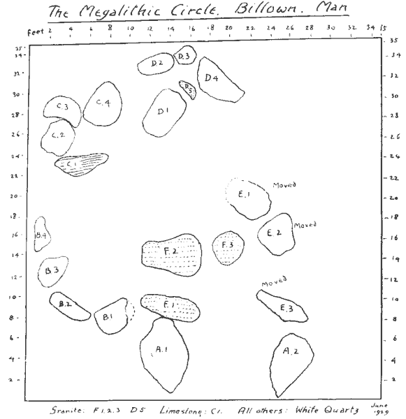
leaving the Meayll the party proceeded to Billown, where Mr. William Cubbon (the Museum Director) pointed out that the monument stood just over one hundred feet above sea level. The diameter of the circle is 35 feet long and 29 feet wide. There are 22 megaliths, mostly of white quartz. There is one of lime-stone in the N.W. corner, and three of granite, all of which are near the centre. The remains form themselves into five, if not six, groups. One group consists of two Portal Stones; the largest is 7ft. long and the other is 6ft. 3ins. long. (See plate 98.)
The present positions of the Megaliths comprising the Billown circle of chambers. Groups B, C, and B are approximately in original positions. The huge Portal stones (A1 and A 2) have fallen. Group E had many years ago been pushed towards the centre by the roots of a falling sycamore.
The excavation of the site was carried out in 1929 by the owner, Mr. T. G. Moore and himself, but no evidence of human burial was visible.
Mr. Cubbon drew attention to the following features:
1 The evidence of fire, covering a long period of time. Charcoal and burnt soil and lime-stone were seen all over the site, in many cases in layers. He referred to the first of the great Celtic feasts held at the opening of the summer, called " Beltane." He could not help thinking that the cult of the Fire had its votaries here.
2 The absence of proof that its purpose was sepulchral. Not a fragment of human bone or even a tooth was found.
3 The absence of pottery within the circle.
4. The paucity of flint implements. There were only a few scrapers of a rude character; most of them showed signs of having suffered fire.
5 Apart from an almost negligible quantity of white rounded stones, the only pebbles found were of grey colour, some round and some egg-shaped, three or four inches long. They must have been taken from the shore about two miles away. There were many unbroken ones, but there were hundreds which, having suffered great heat, had been fractured. It is thought that these might have been 'pot boilers.'
6. Seven holes were discovered, each about four or five inches in diameter and about fourteen inches deep. The holes had probably been made to take wooden stakes. The theory is this, that when these huge blocks were erected it was necessary at some stage to support them, and to lever them into their required positions. This. was done with the assistance of wooden stakes, which had been left in position and rotted away, leaving the holes as evidence.
The nearest area from which the 16 white quartz stones could have come is the southern slope of Barrule, about two or three miles away to the north.
Mr. Cubbon referred briefly to the large earthen mound which is attached to the upper end of the monument. The stone hedge at the north, which was erected about 50 years ago, is built across the summit of the mound. Examination at the northern edge of the circle disclosed several fragments of pottery separated from each other. A polished flint knife and several narrow blades of flint were also found here.
At Rushen Abbey, Mr. W. C. Cubbon gave a brief description of the ancient Church and Monastery buildings, founded by King Olaf I about A.D. 1134, and showed skeletons said to be of some of the Norse Kings of Man and other relics brought to light by excavation.
After partaking of an excellent tea kindly provided by Mr. T. G. Moore, C.P., J.P., of Billown, the party returned to Douglas.
This party drove to the Granite Mountain. Mr. R. H. Kinvig pointed out the main line of highlands, constituting the core of the Island, and the chief points visible were named. This massif is formed of Manx Slates (a term which is rather a misnomer, since only rarely do they yield material for roofing) belonging either to the Upper Cambrian or the Lower Ordovician period. Precise dating is difficult since no fossils of diagnostic value have been found. These rocks were intensely folded during the Caledonian (post-Silurian) period of earth movements, and in its general structural form the highland mass represents a compound syncline (synclinerium). Great igneous activity accompanied the folding, and as evidence of this we have in this district:
(1) the great mass of coarse grey Foxdale Granite significantly placed near the central axis of the Manx Slates (compare, also, the Dhoon Granite which is similarly situated) and
(2) various related dykes, with associated mineral veins, which gave rise to the lead-mining formerly carried on in Foxdale and Glen Rushen.
The outcrop of the Foxdale Granite is not large, but owing to its distinctive nature it is of great interest in connection with various glacial phenomena, e.g.:
(1) Boulders have been carried upwards by the ice-movements, so that they are now found scattered on the slopes of South Barrule, almost to its summit (1,585 feet) - thus attaining a maximum elevation of some 900 feet above their source (height of granite outcrop being between 600 and 700 feet). Similarly granite boulders are found on Cronk ny Arrey Laa at over 1,400 feet.
(2) A well-marked train of granite boulders exists to the south and south-east indicating the main lines of ice movement; and much use has been made of these boulders in building houses and hedges. This feature was studied along the main Foxdale - Castletown road, much granite being observed until the outcrop of Carboniferous Limestone was reached.
From Granite Mountain the party proceeded to Castletown under the leadership of Rev. E. H. Stenning, M.A. During the drive to Castletown the walls of fields and buildings were examined, and the various types of building stone pointed out; through Ballamodda the presence of granite blocks was most obvious, but further away from Granite Mountain the granite became less important, and shales were most evident, while inside the limestone area limestone was almost universally used, though river boulders of granite were visible right down to Castletown.
The party stopped and noted the change over from slate to limestone near Mwyllin Caartee.
The next stop was on. Langness, where the more salient features were pointed out. These were:
(a) The sharply tilted slates, forening outcrops all over the central ridge of the peninsula.
(b) The basement conglomorate beds. These were described and examined. An interesting discussion took place as to the nature of the matrix, and its colour.
(c) The unconformability of the basement conglomerate on the shale.
(d) The red colouration of the shale in the vicinity of the conglomerate.
(r') the green stone dykes in the point of Langness, and the stages in their erosion by the sea. After lunch the party assembled at Scarlett. Here the quarry was first examined, and the value of the stone as building stone discussed. The different layers, hard and soft, were examined.
The party next went to the lime-kilns, and then to the broad layers that run down into the sea. The " pot-holes " in these layers were examined, and their possible origin discussed. The limestone erosion by wind and sea was more closely examined. The well-known greenstone sill was examined, and the stages of its erosion. The nature of the volcanic disturbance which gave rise to the Stack, the basalt of " Cromwell's walk," the agglomerate, was discussed. Unfortunately the tide was too high to allow the party to go on to the Stack, and the time was too short to allow a visit to be paid to the Balladoole quarry, but the formation around Scarlett was carefully examined and the rock structures noticed, as well as the great variety of rock specimens. The agglomerate came in for much attention, and the nature of the inclusions was noted, and the effects of the molten matter on, e.g., the pieces of limestone, so far as they could be seen by the naked eye, proved most interesting.
The party noticed with interest the great variety of fossil forms visible in the rocks and in the stones of the walls.
About twelve members of the association, accompanied by Mr. R. H. Kinvig, were welcomed by Mr. J. R. Bruce, M.C., the Naturalist in charge, on behalf of .Dr. R. J. Daniel, Director. After a brief inspection of the Aquarium and Marine Museum, demonstrations were given by members of the Station staff on various aspects of work in progress:
(a) Mr. W. C. Smith, Curator, explained his investigations into the composition, age, and migrations of the Irish Sea herring shoals, illustrating his remarks by diagrams, slides, and specimens and a sample of herrings recently landed at Peel.
(b) Mr. T. N. Cregeen, Assistant Curator, demonstrated the method of hatching and rearing the larvae of the lobster, which he has developed during recent years. Although late in the season, it was fortunately possible to show a complete series, living, of the earlier stages in the life-history of the lobster.
(c) Dr. Mary W. Parke, Algologist, and Mr. T. R. Bruce, Naturalist in charge, speaking at the open-air spawning ponds, explained the purpose and nature of investigations made during the last three summers into the conditions necessary for the growth and settlement of the young of the Native oyster, and showed living examples of young oysters, of one and two years of age, as well as a few newly settled larvae of the present season.
After this the party joined the Archaeologisls of Rushen Abbey for tea.
In the evening there was a reception by his Honour the Deemster Farrant, F.S.A. (Scot.), chairinan of the Manx Museum and Ancient Monuments Trustees, and Mrs. Farrant at the Majestic Lido Hotel, at which His Excellency the LieutenantGovernor, Sir Moutagu Butler, K.C.S I., C.B., C.l.E., and Lady Butler were present.
Friday, 18th September, 1936.
Excursion to the West.
After the official photograph had been taken by Miss Kirton, the party divided into three sections: (a) Archaeology, (b) Botany, (c) Geology.
(a) Archaeology.
The first stop was at Kirk Braddan, where the Attorney-General (Mr. R. B. Moore), the leader, indicated that the site was probably originally a camp estimated by Dr. Oswald as occupying ten acres. It was pointed out that when the level of the land was lower and Port e Shee was the estuary of the river the situation of the fort was well chosen at the ford of the river with rising land on all sides. The walling of the fort had been to a large extent destroyed - the last remnants were badly disturbed with the removal of trees during the Great War.
Canon Quine had discovered unknown scribings on the disturbed stones which indicated a use of the site in very remote periods.
The party examined the Braddan old church built about 160 years ago, and the leader pointed out indications of an older building and the use of the leaded lights from much smaller windows. The three-tier pulpit was examined with interest, and the vicar explained how service was conducted there during the summer on wet Sundays.
The visitors were much interested in the nine crosses - five of the Celtic period and four of the Scandinavian. It was pointed out how the art had developed and reached its highest stage under the influence of Gaut, whose original designs had been adapted with such great skill by the persons who carved the Braddan stones. He suggested that the two principal patterns, the plait work and the ring chain, were possibly symbolic of the ideas of eternity and life. The plait-work pattern when perfectly drawn had neither beginning nor end, while in the ring chain pattern, each figure grew out of the one beneath, suggesting parenthood and the progress of life.
The figures on the Celtic Wheel Cross, representing Daniel in the Den of Lions, a familiar symbol ofthe resurrection, were carefully studied, and the runic inscriptions were interpreted by the leader, and regret was expressed that the whole story was not disclosed of the tragedy- indicated in the fragment of the inscription recording the treachery of the man Who slew his fellow oathswearer in a truce.
A visit was paid to the new church at Kirk Braddan, and the party then proceeded to St. Trinian's. Unfortunately a shower of rain had wet the grass and only about half of the visitors examined the ruins. The leader recounted the history of the church as discovered by the Rev. T. Talbot and Canon Quine, and the dedication to Saint Ninian of Whithorn, Galloway, one of the great leaders of the Pictish Church. Particulars were given of the Charter of Olaf II (about 1214) granting the hospice of Ballagniba, the church of St. Ninian, with the adjoining lands, to the Prior of Whithorn as a guesthouse for travellers and the poor, and it was indicated that the neighbouring farms of Ballavitchell and Bawshen might well contain reference to the Ballybiatch, a well-known Trish endowment for persons in need.
The ancient foundation of the church was disclosed by the 6th century cross in the floor of the church and the lintel grave. The party examined with interest the small number of crosses preserved in the ruins, and the remains of the Holy Water Stoup. The mouldings of Irish work which had been found in excavating round the ruins indicated that at one time a building on the site had been beautifully ornamented.
Leaving St. Trinian's, the next stop was at the Tynwald Hill, and here the Speaker of the House of Keys took charge and conducted the visitors into St. John's Chapel. Here he explained the geographical position and surroundings - particularly Slieau Whallian, giving the tradition of the witches. He then referred to the name Tynwald - its Norse origin and the earliest references to it in our history. He reminded his hearers that it was the last survival of the old Norse ceremonies, despite its distance from Norway.
He gave some particulars of the old form of ceremony and the duties of the various officials taking part in it, viz.: The Bishop of Sodor and Man, the Deemsters, the Legislative Council, the Keys, the Clergy, the High Bailiffs, Coroners and Captains of the Parishes. He then explained how little the ceremony had been altered, and gave an account of the present day procedure, reading the words with which the Coroner of Glenfaba Sheading fences the Court.
He emphasised the simplicity of the ceremony, referring to the attempts made from time to time to introduce what was modern and garish and what would only turn an ancient and dignified ceremonial into a show. At the close of the address members inspected the Book of Remembrance in the Chapel and then proceeded past the War Memorial to Tynwald Hill, where many questions were asked and where photographs were taken. The great interest taken by our visitors in the proceedings and locality was very obvious.
After leaving Tynwald a move was made to the Peel Castle Hotel at Peel, where lunch was partaken on the invitation of the Peel Town Commissioners, to whom the thanks of the guests were gracefully voiced by Dr. Haddon, F.R.S.
The afternoon was spent on St. Patrick's Isle at Peel amidst the picturesque ruins of the Castle. Canon Quine, M.A., who was leader for the occasion, taking his stand on the highest spot, said the summit area is occupied by a group of three buildings, i.e., St. Patrick's Church, the tower, and an oblong roofless building of 11th century date, which the lecturer suggested was probably an early episcopal palace, that is, residence of a body of clergy in occupation there during the latter half of the eleventh and the whole of the twelfth century. The Church of St. Patrick was the then Cathedral de facto, and for about 150 years.
On the terrace at a much lower level on the east side of the islet is the Cathedral Church of St. German, with episcopal palace or residence of the clergy (on its north side) built at various times from 1190 to 1275, made a Cathedral de jure under Bishop Simon, whose episcopate in Man was 1229 - 1247; and derelict since 1772.
During the expedition of Magnus Barefoot of Norway (lØ7-1103) St. Patrick's Isle was occupied and fortified.
Three other features of St. Patrick's Isle have special interest, i.e., what is called the Sally Port at the extreme N.E. and lowest point of the islet, where scrutiny may yet find the earliest traces of building. It was no doubt the first or original landing place; and very near to it is the well, where sea-farers in early times could obtain water.
The " peel " or Castle on the S.E. side of the Island cannot be older than about 1200, and was much altered about 1300, probably when King Edward I of England seized Man, and re-edified Castle Rushen. The great ring line of fortification around the whole islet (of date about 1500) was the work of the Earl of Derby, evidently to hold Man agamet the King of Scots, in the then struggle between England and Scotland in the reigns of Henry VII and Henry VIII.
As to the origin of the two ecclesiastical foundations, it must be recalled that in the 11th century the great power in the Irish Sea and the Western Isles was Thorfinn, Earl of Orkney. On his death in 1164 the Orkney power collapsed; it was open for noble spirits to win for themselves new earldoms or kingdoms, and Godred Crovan, of the Northumbrian and Dublin line, conquered Man, and also became King of the Dublin Danes. His reign was from 1077 to 1097.
The Dublin Danes had accepted the Christian faith, but not the Authority of Armagh. They obtained from Canterbury the Consecration of the first Bishop of Dublin, 1038; and the first Bishop founded Christ Church, and built the episcopal palace there. Thorfinn of Orkney, following the lead, built Christ Church at Birsay in Orkney. The second Bishop of Dublin was Patrick, consecrated by Lanfranc of Canterbury (at St. Paul's, London): and in his time (1074-84) Godred Crovan conquered Man and also Dublin. To Bishop Patrick and King Godred Lanfranc addressed letters of advice still extant.
Architecturally considered also, it is to this period we must assign the Church of St. Patrick; and not much later, the episcopal palace beside it, Notice has been taken of herring-bone work on both N. and S. sides of the Church. It is a device to prevent side-slip in the courses of masonry; all examples of it, being assignable to the over-lap period, viz., from Saxon to Norman, harmonising therefore with Bishop Patrick's time.
The palace is "Saxon." Its important or key feature is the double splay of the aperture. There are eight windows, splayed outwards and splayed inwards with a lintel in the middle of the wall resting on two vertical jambs, having between them the light aperture about six inches wide.
That this building was made by masons that came here by way of Dublin, but imported there from England, is probable, because, as tested by measurements, their foot-rule was the Old English rule of 13.22 inches, obsolete in England from the 14th century.
With Bishop Symon, 1227-1247, is associated the title of Bishop of Man and the Isles. He was a Benedictine, and Abbot of Iona. When Olaf II (by marriage with the daughter of the Earl of Ross) obtained the lordship of the Isles, Symon, who supported his fortunes, was made Bishop of Lismore, that is Bishop of the Isles. When Olaf II obtained the Kingship in Man he appointed Symon Bishop of Man. Thus for about ten years (till Olaf's death, 1237), Symon was Bishop of Mann and the Isles. But in 1237 he applied to the Pope to release him from the burden of the Church of Lismore; and the Bishop of Moray, by the Pope's authority, obtained the canonical election of a new Bishop of Lismore. It must not be thought that the two titles were always vested in one bishop. Titles of pretension like arms of pretension are clung to often as a claim to a niche in history.
Simon came to Man with the idea of making St. Patrick's Isle a new Iona. He "edified" St. German's Church, that is made it a Cathedral. and on investigation the ruined buildings north of the Cathedral are all in ground plan like those of Iona - so like indeed that it tells the story of a lost cause or a lost ambition.
The party interested in botany were conducted by Mr. G. J. H. Neely to the Isle of Man Forestry Board's Nursery at St. John's, and introduced to Mr. Andrew Johnson, the Forester.
Under the guidance of Mr. Johnson the party were shown through the nurseries, and after wards proceeded up the slopes of Sheau Whallian to view the plantations of British and other trees.
Mr. Johnson gave much interesting information regarding the Forestry Board's efforts to rear and acclimatise plants and trees from all. parts of the world, and especially from the coastal areas of the countries bordering the Pacific Ocean - including South America, Japan, and New Zealand.
The members of the party asked many questions which were fully answered by Mr. Johnson. Before leaving to join the main party at Tynwald Hill and Peel (for lunch), the party's thanks to Mr. Andrew Johnson were voiced by Professors F. E. Fritsch, London, and Dale Carpenter, Oxford.
After lunch at Peel a party of geologists were conducted by Mr. G. J. H. Neely to the Glenfaba Quarry, where the work of quarrying the material, described by Lamplugh as decomposed slate, was watched with great interest, and the various theories relating to the formation were reviewed by the leader. Many of the members of the party handled the substance and commented on it, and many specimens were secured.
The glacial boulders exposed in the over-burden at the top of the quarry, and in Heaps at the bottom, were also seen.
On completing their examination of the quarry,, the members of the party were conducted by Mr. Rough, the manager, through the brickworks, where the processes of grinding up the shale, pressing it into bricks, and baking these in the kilns were explained and demonstrated.
The manager was thanked very heartily for his trouble in showing the party round.
From the Glenfaba Brick Works the party crossed Peel Hill to view the remarkable slate cliffs. Proceeding along the old tram-way, from "The Ladder" towards Contrary Head, the cliffs presented a magnificent sight.
At 4-30 the Geology party met those members who had been seeing Peel Castle, and proceeded with them to Douglas.
In the evening the Mayor and Corporation of Douglas gave a reception at Villa Marina, where some of the guests attended a theatrical performance in the Pavilion.
Saturday, 19th September, 1936.
Again the party divided into three for Archæology, Geology, and Botany.
The party drove direct to Gretch Veg Cairn ("King Orry's Grave"), where Professor Fleure explained the well-known impressive megalithic re inains on either side of a road constructed early in the 19th century. On the west the remains consist of a pair of long chambers separated by upright slabs shaped to form a "port-hole." The approach was probably from the south-west end of the structure
Across the road, and about 150 feet north-east of the chambers just described, are the ruins of a large semi-circular forecourt open to the north east, and an entrance leads from the forecourt into a chamber, as at Caslital yn Ard. Perhaps the forecourt and the pair of chambers across the road were at opposite ends of one giant cairn which the road-makers cut in two. It is; difficult to decide such a point now, but early accounts state that some intermediate structure was destroyed when the road was made.
The forecourt and linear arrangements of the chambers indicate affiinities with a type of megalithic monument, chiefly represented in Northern Ireland and South-West Scotland, but of which Cashtal yn Ard is one of the most notable examples. The date might be placed rather before 2000 B.C.
Afterwards the party visited Cashtal yn Ard, and here they saw and admired the work of excavation and restoration which had for three years been proceeding under Professor Fleure's supervision.
The monument is probably the most complete example of its class known up to the present. Its congeners occur in Northern Ireland from the vicinity of Carlingford Lough westward and northwestward, around the Firth of Clyde, in Cheshire (the Bridestones), and in Pembrokeshire (Pentre Ilan), while monuments with some analogous features are known in Brittany and in Sardinia southwards and in Caithness northwards.
A paved forecourt outlined by eight great standing stones focuses upon a low entry between the two largest of the eight. The entry is formed by two stones, the larger of which has, as a part of itself, a large vein-block of white quartz at the apex of the pseudo-arch. This entry leads into a linear series of five compartments outlined and divided from one another by large slabs, the lateral ones usually sloping inwards. Beyond these five chambers is a large low mound of burnt fragments of stone, some slaggy but yielding no traces of metal smelting.
In the centre of the Mound is a platform of slabs laid one over another. No trace of lnnuan or animal bones has been found as yet, but in Ireland in analogous positions in monuments of this class Mr. Estyn Evans has found pits full of burnt human bones. At some distance to the east a collection of eight small standing stones and one large one has been found. To the north and to the south of the linear series of coinpartinents are two lines of standing stones that approach one another eastwards. The space between the northern line and the compartments was paved. The base of a wall along the south flank of the irnonunient has been discovered and in it, nearly opposite the mound of burnt stones, there are indications of an entry, analogous with that found in a similar position in an Irish monument. Finds include " Neolithic " pottery from the compartments, a portion of a Woman's skull found in the western compartment, and over 1211 white quartz pebbles from the eastern end as well as a few flints, among them a hollow scraper. A full and illustrated description of the monument appears in the Antiquaries' Journal for October, 1936.
The party then motored to Maughold Church, after some delay caused by the narrowness of the by-road, and met the Ven. Archdeacon, who gave a short account of the antiquities to the visitors:
The imposing standing cross at the Churchyard gate is the only one of its kind in the Island. It appears to belong to the late 13th, or the early 14th century, and it is made of sandstone from the neighbourhood of St. Bees. The Rectory of Maughold belonged to the Priory of St. Bees, and it is presumed that the cross and the three-light east window of the Church, which replaced a former lancet one, were given on the occasion of a renovation of the building. At the last renovation a new window was substituted, but the old one was preserved by being built into the wall behind the altar, where the party had an opportunity of inspecting it.
The Churchyard is said to be the largest in the British Isles. At present it covers about four acres, but it was formerly much larger. At one time it was fortified. Traces of a wall and moat on the east side were to be seen within recent times. There were at least seven " Keeills " or small chapels within the enclosure, the foundations of three of which have been laid open.
The site appears to have been that of a religious establishment on the lines of the early Irish Monasteries and the Columban one at Iona, with several small chapels, abbot's house, guest house, refectory, and cells for the monks, all traces of which have long since disappeared.
The present Church, which has been enlarged more than once, appears to date from the eleventh century. The windows are of comparatively recent date, but two small ones of the twelfth century have been discovered in the south wall and have been filled in with stained glass. A font of the eleventh century is built into the west wall.
The Church is dedicated to St. Maughold, who is said to have been one of St. Patrick's converts, a former pirate who on repentance was fettered and placed in a coracle which drifted to the Island. On reaching land he was rescued and received as a holy man. He afterwards became Bishop of the Isle, and was buried in this churchyard.
The owner of the " Staff-lands," which consist of about sixty-eight acres adjoining the churchyard, is supposed to have had the custody of St. Maughold's staff, and to have been responsible for bringing it to the Church for festival processions. According to the " Chronicon Manniæ " the staff was in existence and use as late as the twelfth century.
In the Cross-house in the SW. corner of the churchyard there are about fifty crosses ranging from the sixth to the thirteenth century, almost one-third of the total number found in the Island. There was not time, however, for a detailed description of these.
The combined parties then lunched at the 'lay Hotel, Ramsey, by kind invitation of the Ramsey Town Commissioners. Mr. Coote Lake moved a vote of thanks, and the Archdeacon added a few jocular words.
In tile afternoon the party visited Cronk Sumark and there met Sir Mark and Lady Collet, the owners of that and the adjoining property. Mr. Neely took them to the top of the hillock and called attention to the remarkable viewsto be had from the "Fort."
The Isle of Man, he said, had an abundance of early earthworks of various types - promontory hilltops, plateau, some with one or more encircling moats or fosses.
The position and strength of Cronk Sumark was obvious. It was described as leaving been a strong point in pre-historic times; and, in later days, was occupied and strengthened by the Norsemen.
The shape of the "Fort" itself was determined by the rocky summit of the hill, which is somewhat square in outline. The entrance is at the north-east corner. The northern side is almost impregnable, being defended by a precipitous cliff, while the southern side and flanks were provided with defensive ramparts. The country to the north has been greatly altered since the days when the Fort on Cronk Sumark was occupied. A series of loughs stretched front the Curragh below, towards Ramsey, dotted here and there by islands, some of which are still suggested by the names of farms occupying low hills in the flat areas below
At 3-30 the party descended the hill and left for Orrisdale, to view the remains of the white quartz circle. The leader said that there was very little on record regarding this circle, excepting the fact that in 1866, at the time of the Ordnance Survey of the Island, the owner of the land informed the surveyor that he remembered hearing of an urn being found and taken away.
Mr. Neely mentioned the other sites on the Island where there are heavy white quartz monuments, These include Billown, Llergy Dhoo, and Corvalley. The only known cairn left on the Island of which the main portion is not yet excavated, is at Corvalley. But the one chamber exposed shows it to be of heavy white quartz blocks similar to the one beside which the party stood at Orrisdale.
The leader pointed to two large white quartz blocks forming gate posts which once formed part of the Orrisdale circle.
Owing to the lateness of the hour and the considerable distance to Douglas, it was decided to omit visiting the Corvalley Cairn and to proceed direct toDouglas.
A party of those members who here interested eti geology, botany, and allied sciences, under the leadership of Mr. G. J. H. Neely, proceeded along a route by the Bungalow Station Hotel at the foot of Snaefell, 2,034 feet, and thence by Llergyrhenny to Sulby Glen. A halt was made at the point near Llergyrhenny, where the " Clagh yn Arragh " earthwork crosses the road; and here the leader, after a brief reference to Snaefell as the highest point of the main massif of the Island, pointed out Slieu Maggle, 1,400 feet, at the southern termination of the geological formation, first described in a paper by Watts and Lamplugh, in 1895, as "Crush Conglomerate." The term 'autoclastic " was also applied about this time to conglomerate rocks of this character. The formation, consisting of a slaty breccia, occupies much of Sulby Glen, which it traverses, and occurs in small patches, not sufficiently large to map in other parts of the Island. On arriving at the Tholt y Will Hotel, at the foot of the steep and winding road leading into Sulby Glen the party split up into groups and dispersed in various directions to examine the rocks and flora of the district.
After a short delay at this point, the journey was resumed down the glen. The geologists continued to follow the crush conglomerate, wherever this was possible, in the face of the cliffs along the west side of the ravine, and a halt was made where this formation crosses the road and river, and forms part of the prominent craggy cliff rising at the north-west corner of the junction of Glenmoar with Sulby Glen, and south of "Carrick." The leader took the opportunity of reminding those present that the cliff described had been named by British Association members who visited the spot in 1896, " Lamplugh's Crag," in honour of the geologist who had wrtten the geological memoir of the Island.
After a short stay at tite Sulby Glen Woollen Mills, the route was restused to the northern termination of this section of the Crush Conglomerate at Cronk Sumark Quarry, which provided many good specimens. The party left Cronk Sumark for Ramsey at 1 p.m. for lunch with the archeology section.
After lunch the Bride Hills and Shellag Point were visited by the geologists. Here Professor Fleure drew attention to the evidence for the view that the Bride Hills were terminal moraines of an ice-sheet from the north, and were formed as that ice-sheet retreated. Gravel outwash spread for considerable distances southward from the hills, whereas on the north the hills presented a somewhat abrupt slope down to the lowland which farther north becomes the raised beach of the Point of Ayre.
The difficulty in applying normal terms such a "boulder clay" to the deposits was illustrated. A good deal of the material is gravelly or sandy, but large boulders are well known. In places toward: the east where cliff sections are exposed a separation of lower and upper boulder clay (or fluvio glacial material) with water-laid gravel between can be made out and the upper boulder clay may be covered by similar gravel and wind-blown sand. A possible late Levallois flake has been found in the upper gravels.
This party accompanied the Geologists in the morning, and after lunch proceeded to Ballaugh Curraghs. Bounded by the Orrrsdale-Jurby sand-dunes on the west, and in the south by the Gob-y-Volley scarp, the Curragh is protected from the prevailing winds, and the bare surface of the Irish bogs is absent. The Ericas and Eriophorums of the uplands are here replaced by Molinia and large tracts of Myrica and relatively few species of Carex: and Scirpus are present. Large willows (Salix vimiualis and S. cinerea) and many varieties of Rubus and Rosa are common along stream courses. Vegetation is rank, and many of the rarer inland plants of the island are found here. Former tree growth at periods of desiccation in Post-Glacial times is evidenced by the occurrence of alder and birch pollen at the Boreal, and oak at the Atlantic and later periods of peat formation.
The most recent flora of the Island* quote, about 662 species and sub-species of Angiosperms as the known total. Alpine elements are uncommon as the highest eminence reaches 2,034 feet only, and on the Barrule slates precipitous inland cliffs are infrequent. The Lycopods are represented by three common. types, viz., Lycobodium Sewgo (Fir Club Moss), L. Clavaturn (Stag's Horn Club Moss), and L.Alhinum (Alpine Club Moss). There is nothing comparable to the County Clare concentration of Alpines and Arctic species at sea level. Even Luaula sylvatica (Great Wood Rush), a common plant of damp rock exposures, is comparatively rare in Man. Pinguicula hisitanica (Pale Butterwort) and Cotyledon Umbilicus- Veneris (Pennywort) are two Atlantic representatives in the insular flora, although associations with the Lusitanian province proper are absent.
The following are some of the plants recorded from the Curragh, divided according to habitat; overlap is common.
STANDING WATER.
Vuphar lutea. Yellow Water- Lily.
Myriophyllum spicatum. Spiked Water Milfoil.
M. verticillatum. Whorled Water- Milfoil.
Hippuris vulgaris. Mare's Tail.
Bidens tripartita. Three cleft Bur Marigold.
Menyanthes trifiliata. Bog Bean. Common.
Utricularia vulgaris. Bladderwort.
Sparganium neglectum. Profuse Bur-Reed.
S. angustifolium. Narrow Bur Reed.
Alisma ranunculoides. Lesser Water Plantain.
Potamogeton pusillus. Slender Pondweed.
Equisetum palustre. Marsh Horsetail.
Equiseturm limosum. Smooth Horsetail.
MARSH.
Ranunctdus Baudotii. Baudot's Buttercup.
Saponaria oicinalis. Soapwort. A garden escape. A double aberration.
Hypericum humifusun. Trailing St. John's Wort.
Epilobium obscurum. Obscure Willow-Herb.
Epilobium alsinefolntm. Chickweed-leaved WillowHerb.
Peucedanum Ostruthium. Masterwort.
Myosotis cespitosa. Tufted Forget-Me-Not.
Myosotis Tepens. Creeping Forget-Me-Not.
Euphrasia nevrorosa. Eyebright.
Lycopits europaeus. Gipsywort.
Polygonum Hydropiper. Waterpepper.
Polygonum Bistorta. Bistort. Less common here than in Northern England.
Rumex Condylodes. Sub-species of Clustered Dock.
HEDGES.
Rubus fissus, R. plicatus, R. Lindleianus (rare),
R. Selmeri, R. coryfolius, v. sublustris.
Rosa canina v. lutetiana, R. dumetorum, R. glauca, R. mollis, R. omissa.
Lythrum Salicaria. Purple Loose-Strife. Common.
Humulus Lupulus. Hop. Rare.
Osmunda regalis. Royal Fern. Common.
* A list of Flowering Plants, Ferns, and HorseTails of the Isle of Man. Cyril Paton. 1934.
RECEPTION BY TRUSTEES.
In the evening a reception was given by the Trustees of the Museum. Professor Fleure gracefully expressed the thanks of the visitors, and referred to the generous thought and hospitality of the people of Man and to the pleasure it had been to the British Association members to come to the Island. He emphasised especially the value of the extension of the Museum and saw in it the fruition of the lifework of the late Mr. P. M. C. Kermode for his native Island. He expressed the hope that the memory of that scholar would continue to be honoured and that an effort would be made to preserve a typical old Manx cottage as well as, if possible, a model of a Keeill. Such models would help both scholars and the general public; scholars needed completer visual impressions to help them in their work; the general public needed to be shown the interest of old things and to be trained to observe them and also to preserve them. The Chairman, Deemster Farrant, responded, and gave a short account of the progress of Museum extension and investigation of Ancient Monuments in the last five years.
Sunday, 20th September, 1936.
In the afternoon Mr. W. Cubbon led a party to view the ruined Keeills in Marown.
The ruins of Keeill Pherick, Ballafreer, Kirk Marown
The leader commenced with Keeill Pheric at Ballafreer, and in his remarks paid a tribute to his predecessor, the late Mr. P. M. C. Kermode, in respect to his skilled work on our keeills. As far back as the year 1908 he initiated, almost singlehanded, a scheme to make a survey of these monuments and their rhullicks, or churchyards. In the course of ten years he completed the examination of these monuments in fourteen out of seventeen parishes. His fine illustrated Reports, carefully and skilfully drawn up, have added a new chapter of surpassing interest to our knowledge of early historic times in Man.
Many of the Keeills still existing, as the example at Ballafreer, occupy the sites of the earliest Christian places, of worship. The discovery within their precincts of crosses as early as the fifth century lends support to this opinion. The manner of construction of the Ballafreer Keeill, with massive walls of stone and soil, suggests that it was erected when buildings of stone were in their infancy. Some have been built upon burial sites of the Bronze Age.
There were records of the existence of 144 keeills; there was one in every " Treen," and there were nine in the parish of Kirk Marown alone.
What is known as the "'traditionary Ballad," written in the first quarter of the l6th century, throws some light on these " Treen chapels." After describing how the sea-god Manannan was the first who held Man, the holy isle, or " Ellan sheant," Then came Patrick the gentle,
A strong man full of nobility;
And he drove Manannan on the wave
And his evil and unrighteous servants.
Patrick blessed holy German,
And left him a Bishop in it,
To increase the faith more and more,
And he built all the chapels.
In each Treen Balley he raised one,
For these people to come and pray.
This is the earliest record of the creation of Keeills. The leader took the party to see what is traditionally known as Leabba Pheric, or "St. Patrick's Bed," a huge flat stone upon which it is said the saint had slept; and also the Chybber Pheric, the "holy well of St. Patrick," near by.
The other keeills visited in succession were Cabbal Druiaght, the " Druid's chapel " on Glenlogh; the Ballaquinney Keeill in what is known as the " Fairy orchard "; and the Ballingan Keeill, dedicated to St. Fingan or Finnian.
The last-named is slightly smaller than the others. The building measures 13ft. by 9ft. 6ins. The doorway is placed at the E. end of the S. wall: doors are usually in the W. end. Floors are usually paved; but this is not. The walls inside are faced with unhewn stone in random courses against a bank of earth. The height of the walls is about 4ft. from the floor inside. It is evident that the site was a Bronze Age one, for when examined by Mr. Kermode, much charcoal and pottery were found.
Nearly all the keeills had an enclosure, or " rhullick," in which the dead were buried; and they are raised in many cases, several feet above the adjoining land. At Ballingan the height above the surrounding meadow is about five feet. The size of the enclosure is about 90ft. N. and S., by about 70ft. E. and W.
At the close of the tour, Mr. P. W. Caine, the President of the Natural History and Antiquarian Society, thanked Mr. Cubbon for his interesting and enjoyable leadership; and this was supported by Mr. Coote Lake, the secretary of the Folk-Lore Society. Acknowledgments ought to be made to the respective owners and tenants of the farms on which the keeills stand. They are: Ballafreer: Mr. Councillor Quirk, Mr. J. Looney; Glenlogh: Mr. Quayle; Ballaquinney: Mr. Wm. Cowin; Ballingan: Mrs. Karran, Mr. Faragher.
The visitors departed on Monday afternoon after a somewhat strenuous excursion, which, however, they appeared to have enjoyed. The Trustees and the Director have received many letters of appreciation from those who took part in the visit. One from the Council of the British Association, conveyed through their general secretary, Mr. Howarth, thanking the Museum authorities for the 'admirable arrangements made for their reception and entertainment' is quoted on p. 141 of this issue.
The following gentlemen kindly acted as an organizing committee for the reception, accommodation and excursions of the visiting members of the British Association:
The Deemster Farrant, F.R.A.I., F.S.A. (Scot.), Chairman.
T. C. Qualtrough, Esq., J.P. J. R. Drinkwater, Esq., J.P.
John Faragher, Esq., J.P., Chairman Town Commissioners of Peel.
T. H. Corkhill, Esq., J.P.
Wm. Cubbon, Esq., F.R.A.I., Museum Director.
G. J. H. Neely, Esq., Inspector Ancient Monuments.
Secretary: Basil Megaw, Esq., B.A., Assistant Director.
|
|
||
|
|
||
|
|
||
|
Any comments, errors or omissions gratefully received
MNB Editor |
||