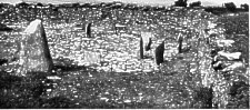
1 Cashtal yn Ard ; east end from south
[From The Antiquaries Journal Vol. XVI October 1936 No. 4 pp373/395]
By Prof. H. J. FLEURE, F.R.S., F.S.A., and G. J. H. NEELY
[Read 26th March 1936]
THE Isle of Man situate in the midst of the Irish Sea as an intermediate station between Ireland and Cumbria, North Wales and Galloway, has naturally played a Considerable part in various phases of western British life in which coastwise maritime movements have had significance. The phase or phases of megalithic construction included, as is generally agreed, a considerable amount of maritime movement along the coasts of western Britain, and monuments of various types were set up. It may be stated at the outset that, since developments even as late as the introduction of Christianity show relations with megaliths, we are not justified, without special local evidence, in ascribing particular megaliths necessarily to an early period, though there is widespread agreement that some must have been in existence at about 2000 B.C., and even possibly earlier.
To early maritime intercourse the Isle of Man offered a welcome station and shelter in crossings in all directions, and it is legitimate to suggest that this may contribute to future interpretations of the numerous diverse types of megaliths which are such a feature of the island. We must not exclude the possibility that they are all the work of the same people, or even of one fairly long period or succession. Nevertheless, it seems at least equally probable that they indicate efforts of diverse groups with different regional connexions and at either the same or different periods. The use of great rough stones for monuments of social significance, when such stones are available, is a natural development in a society which has not yet gone far in the direction of architectural construction. This last statement is by no means to be taken as hinting at local evolution of megalithic notions; the evidence for the spread of the idea up the west coast of Europe, especially from the Iberian peninsula, and farther back from the eastern Mediterranean, seems very strong. The time has perhaps hardly yet arrived for an attempt to state afresh any revised hypothesis relating to prehistoric megaliths in general or even in Atlantic Europe, but it is hoped that the study of the diverse types of Manx megaliths persisting near one another within a small and isolated area may in the future throw light on the problems.
It behoves any student of the Isle of Man to begin by offering a personal tribute to the devoted life-work of the late Mr. P. M. C. Kermode, curator of the Manx Museum. He realized that the island could yield much knowledge concerning the early history of the British Isles and Western Europe, and his Corpus of the Manx Stone Crosses is the best known monument to him, though even that by no means represents the extent of his interests and preoccupations.
In 1932 one of the present writers during a visit to the island was specially impressed by the monument known as Cashtal yn Ard, Maughold,which seemed to be a remnant of what must have been a considerable structure. In a conversation Mr. Kermode asked for co-operation in a thorough examination of it, with a view to ascertaining more details of its plan and significance. The Ancient Monuments Trustees of the Government of the Island not only met the expenses of employing labour, but, as the work proceeded, asked the University of Manchester to form a consultative committee to guide future archaeological researches into the prehistoric relations of the island. This generosity and co-operation are gratefully acknowledged, as is the helpfulness of the Curator and other officers of the Museum. The Isle of Man Natural History and Antiquarian Society and many of the island's citizens, who have taken a hand in the work, helped to reduce incidental difficulties, contributed constructive criticisms, and spread a knowledge of the work and an interest in its results among the general population.
Though it would not be profitable at the present stage to discuss in any elaborate way the various types of megalithic monuments in the Isle of Man before several other monuments have been re-investigated, some further mention of their variety must be made.
The Meayll circle near Spanish Head between Port Erin and Port St. Mary is one of the best known, and consists of six T-shaped cists set in a circle. The monument elsewhere which shows most evidence of kinship with the Meayll circle is one which formerly stood on the hill in Fort Regent, Jersey.
The finds at Meayll circle, including a little pottery, suggest a date about or before the dawn of the Age of Metal. At Cor-valley is a tumulus in which one chamber, walled with white quartz, has been found. At Kew, near St. John's, are the remains of what may have been, in the Breton nomenclature, a Dolmen å galerie. At Billown in Malew,and at Orrisdale in Kirk Michael, are remains of circles of white quartz blocks of considerable size. At Ballakelly, Santon, are important remains of what may have been a monument with chambers and probably a porthole entrance. At the Braaid, Marown, is a complex including a small circle and a number of other elements in process of elucidation, and possibly of later date than some of the other monuments. At Gretch Veg, above Minorca, on the north side of Laxey valley, is what may have been a twin monument related in general type to that at Cashtal yn Ard to be discussed in what follows, while at Ballafayle, Maughold, there are remains of a monument obviously related to both. It will thus be seen that the variety of monuments is a striking feature of the island, especially as reference has been made to only a few by way of illustration, and there is no attempt here to give an exhaustive list of the varieties present. That will be better done when we have examined several monuments.
1 Cashtal yn Ard ; east end from south
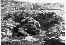
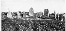
2. Cashtal yn Ard ; remains of central platform in mound of burnt material
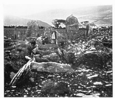
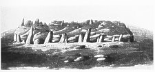
i. Cashtal yn Ard ; series of median compartments looking west
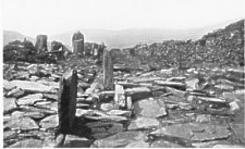
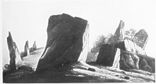
2. Cashtal yn Ard ; small step-way on north side of east end
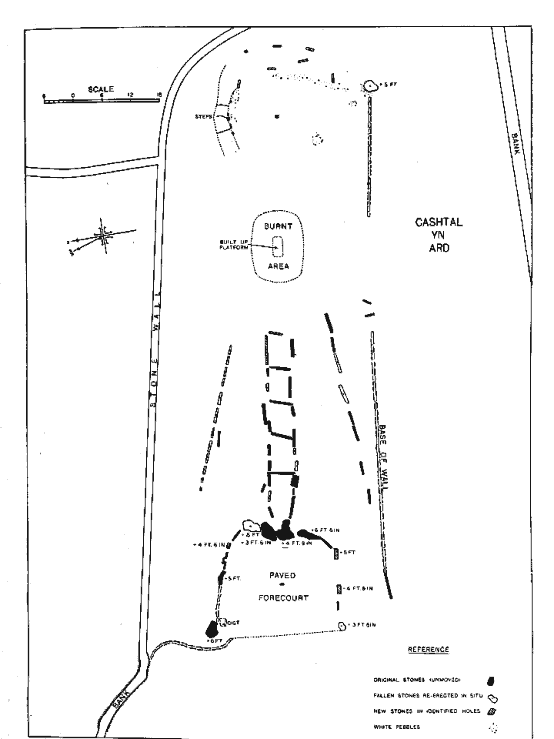
FIG.1. Cashtal yn Ard: plan
Cashtal yn Ard is in Maughold parish, and this matter of situation merits a little attention. The island is made up of a number of diverse physical elements. In the north are the hills of a great morainic system behind the raised beach of the Point of Ayre. To the south of this is a low-lying area including much of the parishes of Ballaugh and Lezayre, and beyond this, to the south again, rises the central hill mass of the island including Snaefell and North Barrule. Towards the south a low line from Douglas to Peel divides the island right across, and on the south of this line the hill mass continues, in diminishing fashion, via South Barrule, with the neighbouring quarries of white quartz at Granite Mountain, right down to Spanish Head and the Calf of Man. Towards the south-east the land sinks to the plains around Castletown with their interesting outcrops of Carboniferous rocks complicating the coastline. East of the Central Mass is a dissected plateau reaching westwards to the foot of North Barrule and other hills, and stretching south towards the south-eastern plain. The part of this dissected plateau between the lowland of Lezayre (Ramsey) and the bay and valley of Laxey is largely composed of the parish of Maughold. If the Isle of Man can be compared to a section of a biconvex lens with its points at Spanish Head and Point of Ayre, the dissected plateau of Maughold must be thought of as an eastward or ENE bulge on that lens-section. It projects towards Cumbria, and its valleys end in small bays which offer alternative landings on both sides, but especially on the south side, of Maughold Head. Maughold village, behind the headland, is in some measure a focus for ways to and from a number of these landings, and, on the analogy of other foci such as St. Davids, Canterbury, Santiago da Compostella, we are helped to understand that in the course of time it should have focused upon its churchyard and church a certain measure of traditional sanctity which may well have been spread about the district in earlier times, as the importance and multiplicity of the crosses seem to indicate. The landings were specially important because they are about the nearest Manx approach to the nearest larger land, namely Cumbria, and they are on that side of the island which gets at least a little shelter from the stormy sou'westers.
Just as near St. Davids and near Santiago da Compostella, so here we find the remains of what have been important megaliths, and Ballafayle, Cashtal yn Ard, and Gretch Veg, as already mentioned, are all morphologically related. Unfortunately it is most difficult to judge the original features at Ballafayle, and it is an archaeological misfortune that a road was long ago cut through the middle of Gretch Veg, perhaps once a twin-monument. There does not seem to be a monument of the same general type elsewhere in .Man, though the complex at the Braaid may show some analogous features when investigation has gone further. Monuments of this general type have long been known from Professor T. H. Bryce's notes' on a number of them in south-west Scotland, and Messrs. Estyn Evans and Oliver Davies have been studying a number in northern Ireland,' while there is one near Congleton, Cheshire, called the Bridestones, which seems even nearer to the Manx type than are the others.
Some monuments in Wales may be related, not necessarily very closely, but every one is impressed by the general resem-blance between the plans of the monuments of the British group just mentioned and the Giants' Tombs of Sardinia, while a damaged monument at Kerlescant, Morbihan, has some kinship.
It seemed just possible that a fair amount concerning the original plan of Cashtal yn Ard might be revealed by study, and the monument seemed to show features more developed in certain respects, if less in others, than the related Irish-Scottish examples. These considerations gave special weight to the effort to examine the monument.
Cashtal yn Ard is situated on the summit of an important part of the dissected plateau above mentioned, and from it there is a fine view to the east over the sea, which can be reached in about a mile at Port Cornaa, a landing that is of at least medieval importance, while there are other landings eastwards towards Maughold Head some two miles away. It may be mentioned that Ballafayle also commands a considerable and analogous view.
The moorland has a relatively thin soil a few inches deep, and beneath this is yellowish clay of a tough character. It was found by testing in a few places that much of the yellowish clay had never been disturbed and that therefore, by careful removal of the soil, it was possible to reveal socket-holes that might be those of stones once forming part of the monument but subsequently removed. This fact proved to be of the utmost importance in the course of the work.
The monument is orientated very nearly W-E. At the west end some large standing stones, the largest almost prone when we came to it, outline a sub-rectangular area which was first examined. It measures 26 ft. 6 in. by 19 ft. 6 in. On this area were heaped loose stones to a varying depth often exceeding one foot. These loose stones were removed from a portion of the area, and it was found that in the west they overlay slabs which covered the soil beneath. Towards the south-eastern part of the area, where there were fewer loose stones and the surface was correspondingly lower, there were found small piles of slabs at certain points on the circumference of a space without them. This suggested that the slabs had at some time been removed from this space and piled up around it, and it was decided to re-lay them, as it seemed probable that they had been removed recently, perhaps by some one trying to examine the monument. It was, however, deemed proper to mark a difference between the paving slabs that were found in situ and those re-laid, and an arrow-head was engraved on each of the former. As it became clear that these slabs formed an ancient pavement of a forecourt outlined by standing stones, that pavement was completed by addition of slabs near some other places whence, as will be stated below, standing stones, and with them no doubt paving stones, had been removed. It is evident that it once had a downward
slope from the west to the portal. In the centre of the forecourt, as the loose stones were cleared away, a small stone was revealed in a vertical position facing the entrance to be described below. This stone was jammed in its place and left standing as possibly an original characteristic, though very small and perhaps an accidental feature.
|
Diagram of Arrangement of Standing Stones around the Forecourt |
||
|
N1 |
Pn Ps |
S1 |
|
N2 |
S2 |
|
|
N3 |
S3 |
|
|
N4 |
S4 |
|
The outline of this forecourt with its standing stones received attention, and it will make the description of the work simplest if certain results are in a sense anticipated by giving a numbered sequence of stones- N4, N3, N2, N1, Pn, Ps, S1 S2, S3, S4.
N4 and N3 appear to be in their original positions, and nothing was done to them. About half-way between N3 and N1 a socket was looked for in a blank space, and was unmistakably found. A stone was set up here to mark the socket, and it was engraved with the date of its erection to prevent any possibility of error in the future. N1 is a very large stone, and it was almost prone, while the socket from which it had all but come away was easily cleared. Thanks to the enthusiastic help of Mr. Corteen, as well as of our staff of workers, this stone was reset in the erect position which it had undoubtedly occupied until relatively recently. Pn and Ps are both in their original positions and relations. PS has a lobe mainly derived from a vein of white quartz, and this rests against Pn so that there is an entrance or portal, with the actual entry 3½ ft. high, and a flat slab paving the floor of the portal at a level a little below that of the forecourt; another flat slab at a slightly higher level lay just outside the portal floor, and there was a small hollow under it.
S1 is a massive stone standing over 6 ft. above the soil and, like N1, standing out of a bank raised a little above the level of the forecourt. It is evident that S1 and N1 are stones of special character and importance distinct from N2, N3, N4 and S2, S3, S4. Certain characters of these stones and of some others will be mentioned later in comparing the monument with others. On the south side no standing stones were at first visible, but careful skinning showed that the three sockets were present, and then a large but much damaged stone was found, buried, but in such a position as to suggest very decidedly that it had come from the socket S4. The broken pieces of this stone were found to fit together and were cemented on, but we cannot be sure that the whole stone is now united; it has been set up in the socket S4 and is now much smaller than N4 or N3, which are both originals. As, however, it is almost certainly the original stone, and the cement is plainly visible, it was not engraved with date of re-erection.
S2 and S3 are sockets, clearly identified; and stones, kindly presented by Mr. Roberts of the Barony, were erected in them to mark them, and were engraved with date of erection.
Just within N4 was found what was clearly a partially collapsed cist with its longer side nearly parallel to the inner face of N4. The long stone covering the cist was more or less in situ. The cist contents included some light-coloured fine-grained earthy material which was sampled, sieved, and examined; it yielded no evidence. We are indebted to Professor Forde of Aberystwyth for drawing our attention to a Gist in a somewhat similar position in the ' forecourt' of the great chambered megalith at Kercado, near Carnac, Morbihan, Brittany.
The line between N3 and N4 was marked by low vertical slabs which apparently completed the outline between the two giant stones. Unfortunately a great blackthorn tree had grown here with a baffling root-system that was pressing stones out of position in all directions and had almost hidden even N3. This large bush was removed, and dozens of powerful roots were followed inch by inch into the ground and extracted as completely as possible, care being taken all the time not to disarrange stones more than was inevitable. It would seem that there was a little dry walling behind the vertical slabs between N3 and N4. A small vertical was found in situ between N1 and N2 and another between S3 and S4 and they gave the impression that the outline of the forecourt had been completed between the great stones by small verticals. It was then completed by us. The portal gives entrance into a linear series of compartments with low E-W walls and rather lower verticals set transversely, making five compartments. The slabs forming the side-walls of these compartments in most cases sloped inwards. Outside the side walls on both sides of compartment 1 were great piles of slabs that might conceivably have been remains of collapsed corbels, but on examination seemed to be mere packing. Soil between and under them was sieved without result. Some of the stones of the side walls of the compartments had fallen out or in, and were reset. It seems evident that there is at Cashtal yn Ard no trace of the imbricating arrangement of the stones of these side walls noticed by Bryce in Arran at Carn Ban and at the Giants' Graves, Whiting Bay. A few traces of paving were found, but these compartments had been to some extent examined in the nineteenth century, and it was in compartment 1 that most of the finds were then obtained (see pp. 388-9I, FINDS).
Whether these compartments were originally roofed or not cannot be stated with certainty, but probably they were. A large flat slab found in the locality had had names engraved on it late in the nineteenth century, when it must have lain more or less horizontal. Local tradition suggested it had been part of the monument. We therefore laid it across one of the compartments to indicate to visitors that the compartments may have been roofed, and also in the hope that visitors who take pleasure in engraving their names may confine their efforts to this stone, which can easily be removed if it is found to be misleading. The floor of the compartments was scraped with special care and the material sieved. A few flints and fragments of pot were found, and a layer of black soil was demonstrated. On either side of the line of compartments there was an accumulation of loose material up to the level of the side walls; it was carefully removed with much fruitless sieving, and on the south side various large slabs lying prone were discovered which completed an oblique line long known to exist (compare fig. 1 and fig. 2).
On the north side the accumulation of material was greater, and first of all a large slab F was found securely fixed in a vertical position in line with N3 and N4 but opposite compartment 2. Attempts were made without avail to trace a line from this slab in any direction. Clearing round it led to the uncovering of a good deal of paving on the north side of the compartments. This led to speculation, suggesting that probably the space on the south side of the compartments between them and the oblique line of low vertical slabs above mentioned had once been paved, but it had obviously been disturbed a good deal and we could not come to any sound conclusion on this point.
Proceeding with the clearing of loose material on the north side we found that some large slabs, apparently once vertical, had been more or less overthrown by accumulation of material; one was resting against F. Several hypotheses were tried to give a scheme of reconstruction, but eventually with more clearing it became almost certain that we were dealing with the remains of what had been a series of vertical slabs along an oblique line corresponding to that on the south. So far as could be ascertained there were several sockets along this line and the stones were set up. The Rev. S. N. Harrison, in his diagram drawn in 1884 (fig. 2) in Jewitt's article quoted below, had already indicated that probably this northern oblique line would one day be found. Before completing the clearing of this series we had for a time a suspicion that some of these stones might have formed a small cist, but that idea became untenable as the work advanced and the northern oblique line revealed itself more completely.
Following the northern oblique line westwards we lost trace of it at about the level of the standing stones (or sockets) S2 and N2. Whether this is the original end or not we could not say; the southern oblique line reaches as far west as an N-S line through N4 and S4; perhaps the northern oblique line was interfered with at its west end when a field hedge near by was built.
North of N4 we found traces of a low kerb holding the soil on the east at a level a few inches above the level of the field to the west, analogous therefore in some measure to the horn of a horned cairn, for it is probable that this kerb supported and held in the base of a considerably greater mound.
Clearing of loose stones was carried on eastwards and a certain number of paving slabs was found east of the series of median compartments as well as to the north and the south of this. After skinning away, over a considerable area, some 3 ft. thickness of loose stones, we came upon quantities of burnt shale fragments, reddish and brittle, along with some fragments of charcoal and black powdery material. This was discovered 62 ft. east of the western portal of the chambers. Continued clearing revealed a mound of burnt material, 20 ft. E-W, 12 ft. N-S, and some 4 ft. high.
In the centre of the mound of burnt material were noticed some slabs and, after clearing a portion of the small shaly burnt material, it was ascertained that the mound contained a central platform built by laying slab over slab. Mr. Estyn Evans in Northern Ireland investigating analogous monuments has found an oval enclosure in a position analogous to that of our mound, i.e. beyond the line of chambers in one of those monuments. It had no mound or platform, but he found along the median line of the enclosure three pits containing cremated human bones. We therefore looked for pits and have not as yet been satisfied that they exist. It is true that at the east end of our mound we found the burnt shale fragments going some 18 in. down into the earth, and we examined and sieved material, finding two tiny fragments of whitish material but nothing that could be identified as bone.
It was felt that, as this burnt mound and its central platform are apparently unique features, and the position seems to indicate that they form an integral part of the monument and are not some subsequent construction accidentally placed here, the platform should not be unbuilt for the present lest evidence should be unwittingly destroyed. It is hoped that analogous features may be found in other monuments, and then it should be profitable to investigate this interesting and probably important problem more exhaustively. In the meantime the hypothesis that this was a place of cremation or sacrifice, animal or human, may be lightly held.
Farther east it was noted that the north and south oblique lines of stones and the median line through the compartments converged towards a point 76 ft. east of the portal. Here, buried under loose material, was found a prostrate slab 2 ft. 6 in. in height, with one end more or less wedged between two smaller slabs. It had apparently fallen on its side and gave the impression of having once stood here, wedged in below as just mentioned. We therefore set it up again, though we cannot be quite certain that our decision was the right one. It seemed however the best way to ensure the safetyof this stone pending possible confirmation of its importance by analogous discoveries elsewhere. From this point the ground fell away 3 ft, on the east. Mr. Cannan told us that he believed a stone had formerly stood at this spot.
Investigation along the southern side of the monument revealed, outside the southern oblique line, the basis of what had apparently been a dry-wall line with occasional rather small vertical slabs. This line was carefully examined for possible sockets of giant stones, but none was found save at its eastern end (see below). It was felt that this dry-walling should be re-erected to the height of a foot or more above the ground to secure its preservation. We have no indication on the ground of what its original height may have been. It may be referred to as the southern limiting line. Along this line, in a position nearly south of the east end of the southern oblique line and the line of the chambers, were two very firmly fixed slabs projecting some inches above the ground as though they marked an entry, and between them and to the north of them lay slabs that may well have formed a way in towards the mound above described.
. We cannot say whether these two slabs are the stumps of stones that once stood higher and were broken away at some time, but Mr. Cannan told us there had been two tall stones here. The occurrence of what may be tentatively called a lateral entry is interesting especially in view of the occurrence of this feature at Cullamore, in Tyrone, Ireland.
Beyond this supposed lateral entry eastwards the southern limiting line was a little indefinite in places, but soon became well marked again, and its continuation led to a giant stone lying prone at what may be called the south-eastern corner of the monument. A socket was found here, not quite as deep as might have been expected, but still almost certainly a socket and not a result of pressure from the superincumbent giant stone. This stone was then set up, and near its western base was found a little burnt material, while near its northern foot were a number of smooth white quartz pebbles.
At first we thought our southern limiting line turned north-ward some 3-4 ft. west of the foot of the great stone just mentioned, and this may indeed once have been the case. We were, however, later to uncover some more features in this area, and we can but say that this may be a very slight hint that those features represent an addition to, or alteration of, the original lay-out of the monument. This must, however, not be empha-sized in any way; following the base of dry-walling in stony ground is difficult unless one has clear indications along a straight line.
It could not be decided whether there had once been a dry-walled limiting line on the north side of the monument, but this is probable, and in that area a good many slabs were found, but here we were near the hedge-wall built at some time between two fields, and it was impossible to argue with confidence.
Clearing loose material northward from the neighbourhood of the great stone at the south-eastern corner, we were able to trace the former downslope of the ground from the neighbour-hood of the stone set up at the convergence of the median line of the chambers and the two oblique lines. On the old soil level we found six fairly large slabs lying prone, obviously very distinct from the loose material. A discussion led to the hypo-thesis that they might once have formed a straight or curved line from the south-eastern giant marking a limit of the monument. It was therefore decided to probe the soil in the hope of uncovering sockets which would be long and narrow because the stones mostly had a slab form. After much probing seven such sockets were identified, and it was seen that the stones concerned might have been separated from six of them by being thrown down. The socket without a stone was to the north-east and it was soon noted that in a wall a yard away and opposite the socket for which we had no stone there was one large slab ; offering a marked contrast to the other stones of the wall. We could not unbuild the wall, so we took a reasonably similar slab and set it in the socket in question. We thus reconstituted a group of seven stones arranged as in the diagrammatic plan, a totally unforeseen scheme of arrangement and one of which no other examples are at present known to us.
Continuing our clearing northward we soon found beneath the loose material some overlapping stones forming shallow steps. We at first thought this quite accidental, but, after carefully clearing by hand, it was seen that these horizontal slabs forming the steps had been carefully jammed at the side by the hammering to of small stones. We are therefore bound to conclude that this is a deliberate construction, and we have followed it up to the higher level towards the mound of burnt material, but it stops short when it reaches that higher level and does not go all the way to the mound. It must have been some special path, probably of ritual significance, and its presence gives proof, if such were needed, over and above that given by the finding of the six slabs and the seven sockets, that this collection of stones at the eastern end of Cashtal yn Ard has meaning in relation to the monument. Whether this eastern construction is contemporary with the rest we cannot decide ; it may be later, we feel confident it is not an earlier feature to which the rest of the monument was added.
Before leaving this section of the account of the monument it must be stated that in a field wall a few yards to the south of the monument there stands a remarkable stone with the top shaped to give a median hollow between two projections. We cannot but think it once formed part of the monument, but not being able even to guess where it once stood we have left it in its present position, not without some fears for its safety.
It may be useful to reprint for reference the short account of a previous examination published in the Reliquary for Jan. 1885 by Llewellynn Jewitt (pp. 166-7)
In the parish of Maughold, the remains of a tumulus called ` Cashtal-yn-Ard', stands on the top of a rounded hill, the `Ard', about 500 feet above the sea. The situation is striking. On the north and north-east lies the lovely valley of Corna, whilst in the distance rises up North Barrool. From the north, round west to south-east, are various hills known as ` Corrany Crag', ` Maels of Ballig', ` Ballellin ', and `The Barony ', on which are ruins of an old chapel, ' Cabal Kiel Vael ', and several small tumuli, two of which are within the chapel yard enclosure. The east is open to the sea, across which can be seen the mountains of Cumberland.About sixty years ago, when a sketch was taken by Dr. Oswald for his work, Vestigia Antiquiora', the tumulus was surrounded by a rough walling of large stones. The covering consisted chiefly of quarried stones laid flat over each other, about four feet high, and an incomplete circle stood at the western end. Since that time the whole of the walling has been taken away save one stone at the east end, as have all the covering stones, and several of the stones out of semi-circle. Many of the large stones forming the chambers have also been broken or removed, leaving its present condition as shown in the plan on plate XIX (fig. 2). The length, from east to west of the remains is 10y feet, breadth at west end 50 feet, east end 40 feet. The whole seems to have been divided into two parts. The western part, including the semi-circle, is 70 feet long, the east portion 35 feet, and lower than the other. There are also traces of a cross wall (a). From the back of the semi-circle eastward, is a central row of chambers 38 feet long. On the north and south of this have stood rows of large flat stones on end, a few of which still remain. The junction of these side rows with the semi-circle, and the turn of end of the semi-circle, resemble that of the Uley tumulus. The arc of the semi-circle is 70 feet, and the distance between the outer stones 32 feet. The largest stones are 10 feet high, and between the two central ones is an opening into chamber (1) 1 foot 8 inches wide.
A cutting was made across the inside of the semi-circle in an east and west direction, when layers of grey unctuous earth, with fragments of charcoal were found about two feet below the present surface. In chamber (1) 10 feet long and 5 feet 6 inches wide at bottom, with side stones leaning towards each other at the top, were found black carbonaceous and grey unctuous earth, with fragments of charcoal. On the north and south, under side stones, were pieces of bones; on the north, portions of a skull, suture open ; upper jaw bone, with teeth regular and sound of a young person, and other fragments; also pieces of two different urns, one of crushed granite and black, about two-thirds of an inch thick, the other thicker, red, and of more earthy material. Near the east end was a cist without covering stone or west side stone, with portions of bone in the north, and on the south end fragments of a smaller urn of crushed granite, thickly spangled with mica.
In chamber 2 were found layers of black carbonaceous earth with charcoal on flat stones, placed one over the other, and underneath a layer of the same grey unctuous earth as in chamber 1; a cist also stood at east end. In chamber 3 was the same kind of black carbonaceous and grey unctuous clay, with fragments of charcoal and few pieces of flint. The whole of the chambers have been disturbed before, No. 2 least so.
1. Cashtal yn Ard; the Forecourt
2. Cashtal yn Ard; from a drawing by G. W. Carrington (1822), see p. 386
3. Cashtal yn Ard ; Forecourt from south-east, from a drawing by G. W. Carrington (1822)
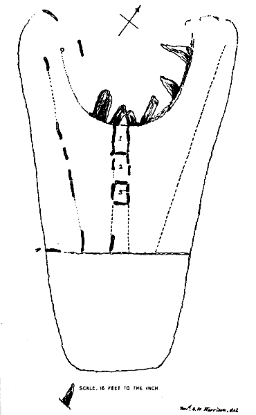
FIG. 2. Cashtal yn Ard : plan from the Reliquary, January 1885
A reproduction of the sketch referred to by Dr. Oswald apparently cannot be traced, but one made about the same time (1822) by Mr. G. W. Carrington is reproduced (pl. LXIII, fig. 2). It is difficult to compare this in detail either with what we found in 1932 or what we have been able to set in place again. None the less a few points emerge. Apparently the large stone at the east-south-east end is a survivor of a series that once bounded the monument. Apparently the artist raised the stones of the fore-court in his sketch (left) probably to show them clear of the other stones. The tall stone farthest to the right in the foreground appears to be our east-south-east stone and, if so, the smaller stones farther to the right are of interest. It will be noted that there is a pair, one standing behind the other, rather like our smaller stones at the east end; there is also a row of three as we also have found, from stones and from sockets. There is a lower one visible between the two among these three which stand farthest to the right; this might well be the northern one of our eastern group. A puzzle which remains unsolved is that we have not found as yet adequate traces of sockets of large standing stones on the south side of the monument. We have the ESE stone and two bases apparently marking a lateral entry. Perhaps other sockets could be found by digging farther out. We have sometimes wondered whether the stone now embedded in the field wall (p. 385) is part of the set of great standing stones drawn by Mr. Carrington. But it is probably not in its original position, and none of his tall stones shows the hollowed top. Among voluntary helpers we number many friends, and offer our special thanks to Miss Dunlop, Messrs. Bregazzi, Corteen, Elwyn Davies, M.Sc., D. Garside, B.A., Heaton, S. A. S. Huzayyin, Ph.D., and R. Miller, Ph.D. His Honour Deemster Farrant, Mr. Ramsey Moore, H.M.'s Attorney-General, Rev. Canon Quine, and Mr. W. Cubbon, Curator of the Manx Museum, helped us by their visits and suggestions.
Our staff included, in various seasons, Messrs. Bell, Corkill, Curphey, Haygarth, Kerruish, Milroy, Mylchreest, Quane, Quirk, Ratcliffe, and Tate, several of whom contributed mate-rially to such success as has been achieved, through intelligent enthusiasm and often ingenious suggestions based upon careful observation of points we might easily have missed.
I. Here and there are found beach-worn white quartz pebbles, but, in the eastern area just discussed, no fewer than 125 were collected. Concerning these pebbles in the Isle of Man, we know that they are said to occur in the cists of the Meayll circle and in barrows with cinerary urns as well as over lintel graves and in other Christian burials down to the seventeenth century. They are also a feature of early Celtic Christian burials in Wales. We also know they are considered lucky in certain connexions (note white and black balls in various ballots) but unlucky in others, e.g. a fisherman putting pebble ballast in his boat will pick out any white stone that happens to be shovelled in, spit on it, and throw it back into the sea; perhaps the stone thrown is lucky. This idea is also found in Scotland. To throw a white stone into a well, with a name written on the stone, has been on the Welsh border a ritual accompanying a curse; without a name on it, it might help a cure. To possess a white stone, in some parts of Scotland, is part of the equipment of a magician. Bathers in parts of Scotland used to throw three white stones into the sea before going in themselves. The text from the Book of Revelations, chap. 2, v. 17, relating to a white stone, in the message to the church of Pergamos (near Troy) may be called to mind
To him that overcometh will I give to eat of the hidden manna, and will give him a white stone, and in the stone a new name written, which no man knoweth saving he that receiveth it.
2. Pottery. Some fragments of pot were found in the chambers, but most had been discovered in the earlier excavation mentioned above (pp. 385-6). It remained for us to examine this pottery and to consult Mr. Stuart Piggott' and Mr. Harold Peake on the subject. To both these gentlemen we are grateful for opinions kindly given. The fragments differ among themselves.
(a) Some pieces are of brownish clay with a brown surface, and reasonably compact. The largest piece has an irregular external surface with traces of an attempt to polish here and there. It is part of a vessel which had an external rim-diameter of about 196 mm. ; the rim is bevelled to some extent on the inner side. The inner surface is smoothed and about 30 mm. below the rim the surface is slightly raised.
(b) In some pieces the clay is practically black in places and fairly dark generally. The largest piece has an outward-turned rim and is part of a pot with external rim-diameter of about 225 mm. One fragment has some straight-line decoration on it.
(c) Coarse dark clay fragments with what seems to be a red slip laid on the outer side. One piece shows a fragment of a shoulder in the red material, and another fragment has traces of linear decoration. None of the fragments is of really fine material, but those classed under (c) are coarser than those classed under (a) and (b). So little is known of the very early pottery of the western seaboard and islands of Britain, or of its relations to continental or other pottery of the time, and the fragments are so poor that it seems wisest not to say more than that it has a family relationship to Windmill Hill A, but this may not mean much. We need to know more about French pottery of the period.-` See also Stuart Piggott, Twenty-eighth Annual Report, Manx Museum and Ancient Monuments Trustees, 1933, P. 8.
3. Bones. Apart from a few minute fragments too small to determine we have found no further human bones. Mr.Harrison describes some he found, and the portion of a skull was in the possession of the Manx Museum in 1932 ; it had belonged to a youngish woman.
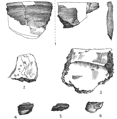
FIG. 3. Pottery (1/2) (from a drawing by Miss Dunlop)
4. Fragments of charcoal were found here and there, and especially near the large stone at the east-south-east corner and in connexion with the mound of burnt material.
5. In the mound of burnt material surrounding the central table were numbers of pieces that looked like slag. Professors F. C. Thomson, of Manchester, and C. H. Desch, F.R.S., of the National Physical Laboratory, kindly examined these fragments independently, and both stated that there was no indication whatever that they had any relation to any metallurgical process. They are probably the result of repeated fires on the same spot.
6. A small, featureless, bronze bar was found near the surface on the southern limiting line, or dry-wall, of the monument. We could not offer any opinion as to date.
The poverty of the finds is a remarkable feature that gives our site an analogy with those in Wales rather than with the better furnished graves found in Ireland. There is nothing in the finds that opposes the ascription of the monument to a late Neolithic phase. What that may mean in dating is difficult to estimate.
It is certainly noteworthy, as has already been stated, that three monuments obviously related in their morphology occur in Maughold parish, whereas nothing of the kind has as yet been found elsewhere in Man, though megaliths of other types are a marked feature in several districts. This suggests that the three, Gretch Veg, Cashtal yn Ard, and Ballafayle, are the work of one people. We can unfortunately barely surmise what Ballafayle may have been like in detail, but of Gretch Veg a good deal is known in spite of its mutilation, long ago, for road making. It was a still larger monument than Cashtal yn Ard, and there are differences which suggest that the builders were not too hidebound by one particular tradition.
At Gretch Veg, in the part of the monument east of the road are traces of a forecourt with an entry into a set of compart-ments, suggesting a close analogy with Cashtal yn Ard, save that in the latter the forecourt is at the west end of an east-west scheme, and in the former at the north-east end of a north-east-south-west scheme. At Gretch Veg, also, we do not get the two giant stones one on each side of the entry. Only a part of one chamber remains on this side of the road. On the west side of the road, however, very nearly in line with the entry and the remains of the one chamber on the east, is a linear series of 3 rectangular chambers, and one of the partitions here (the more north-easterly) is a `portholed' partition. At the southern corner of this linear series of chambers is a very tall standing stone. It is possible that Gretch Veg is a twin-monument, but we cannot be confident. If it were all one monument with a continuous linear series of chambers it was certainly a very curious one in view of the great length involved (160ft.)-length enough for almost 15 chambers of the size of the existing ones. We are therefore inclined to rule out the idea of the whole being one series, and to think of a pair of monuments probably ' facing' opposite ways. One may compare with this in a distant fashion the monument at Carnagat, county Tyrone, Ireland.
Across the water in Ireland Estyn Evans is cataloguing many monuments that are related in general type to that at Cashtal yn Ard and that at Gretch Veg, but it would appear that none is as large or as complex, save perhaps the one which once existed at Annaghclochmuilinn, Armagh, Ireland, and of which Macalister has made a study. This monument had a forecourt that apparently measured about 33 ft. by 2o and a centrally placed entry from this forecourt into a linear series of 4 compartments. The forecourt lay on the north-west of the monument, which stretched south-eastwards.
We may surmise that orientation was a very variable affair among monuments of this class, but that forecourt and compartments were more consistent features.
T. H. Bryce's studies of monuments with forecourts and chambers in a linear series in Arran and Bute, Firth of Clyde, revealed long ago the general type of these monuments, Carn Ban, Kilmory Water, and the Giants' Graves, Whiting Bay, being nearest to the type under discussion. Apparently neither in these nor in the great majority of the Irish monuments of the type, with the probable exception of Annaghclochmuilinn, does there seem to have been such a monumental forecourt as at Cashtal yn Ard.
Until recently nothing was known of any feature belonging to these monuments situated beyond the end of the series of chambers away from the forecourt; Estyn Evans has now found at Doey's Cairn (Antiq. Journ. xvi, 208) a forecourt leading into one chamber beyond which a marked-out area shows three pits full of human cremations. If this area with the pits corresponds with the mound of burnt material around the central platform described above for Cashtal yn Ard, then the hypothesis which would make that mound a place of cremation is considerably strengthened. So far we know of nothing elsewhere that gives any bases of comparison with the features at the east end of Cashtal yn Ard.
The Bridestones, east of Congleton, Cheshire, still show traces of a forecourt, a deep entry closed by a slab and with two chambers separated by a cross slab which had a porthole, half of which is preserved. There is every probability that formerly one or two more chambers stood beyond the present one. Old drawings, the trustworthiness of which in detail we cannot yet check very closely, make the forecourt an elaborate one, apparently analogous with that at Cashtal yn Ard.
While Wayland's Smithy belongs to a tradition somewhat different from that which built compartments in linear series, it seems likely that it had a forecourt facing the entry with tall standing stones, now fallen, but four of these are still lying where they fell.
Traces of forecourts, or monumental entries, occur in Brittany, and there, at Kerlescant, Morbihan, a long passage was divided into two chambers transversely with a porthole in the transverse division as at Gretch Veg. The porthole in a transverse division also occurs in monuments of the Paris basin in the Marne area, and also in megaliths in Hesse-Nassau, where also there is evidence of cremations as well as of inhumations.
The resemblance in ground-plan between Cashtal yn Ard and the Sardinian Giants' Tombs has long been known, and there can be no doubt as to some kinship between them.
We should prefer to leave any elaborate discussion until after more of the megaliths of the Isle of Man have been examined in some detail. For the present it may be useful simply to say that we appear to be dealing with the minglings of currents of thought and tradition among which the following principal ones may be mentioned:
(a) The idea of collective burial by inhumation in a chamber roofed either by corbelling (South Spain, Ile Longue in Brittany, New Grange, etc.), or by slab-roofing (Spain and Portugal, Kercado, etc., in Brittany). The chamber is often approached by a passage which leads in from an entry that may have some form of approach suggesting a forecourt (Kercado). Details suggest that in this case the idea of reincarnation may have been present in the minds of the persons concerned, and that the passage and chamber may have symbolized the womb of the Earth-Goddess or Mother-Goddess. If the idea of cremation replaced that of inhumation one would expect a place of crema-tion in the position of the former inhumation chamber; further, it would be natural that the passage-way should be converted into a place of interment of the remains.
(b) The idea of the forecourt so strikingly represented in Sardinia. The way from the Western Mediterranean, including Sardinia, across Southern France to the Atlantic and northwards past Brittany to St. George's Channel and the Irish Sea was clearly of great importance when the megalithic habit was spreading. The importance of a relatively late development of megalithic activities on either side of the South French route in the Cevennes and the Pyrenees has been well brought out by Gordon Childe, but a little more allowance might be made for gold washing and analogous activities in the Cevennes.
(c) The idea of the long passage-chamber flanked by large standing stones and transversely divided by partitions, with the porthole in some cases. This comes into our Irish Sea-Clyde series in the cases of the Bride Stones and Gretch Veg. This has apparently central European connexions, as Kendrick has pointed out. In Hesse-Nassau cremation played an important part.
(d) The idea of the circle, which is specially developed in the British Isles and which seems to have influenced the idea of the forecourt.
On the whole one is inclined to look upon Cashtal yn Ard, Gretch Veg, and the Bridestones as intermingling these elements in varying degrees in the different cases. Some other monu-ments in Wales would seem to be related, but there, as among the Long Barrows, both of the South Country and of the Cots-wolds, tradition (a) has more influence than in the monuments under consideration, and some other Breton features have to be taken into account.
It seems likely that we are dealing with interwoven strands of tradition and religious custom with a background of coast-wise maritime movement via Spain and Brittany and an associated development involving the route across the south of France. The links of Brittany with the Marne region are clearly attested in many ways and brought a more continental element into the network. Holland and the Medway furnished another strand of tradition. So we get entries of ideas into the British region at least via Dorset and the Medway in the south, and on the west via Cornwall, South Wales, and the Irish Sea coasts with the Firth of Clyde as an extension of the last.
A feature that is conspicuous at Cashtal yn Ard must be noted. The standing stones on either side of the entry into the linear series of compartments are specially impressive. That on the north, i.e. on the right hand of any one standing at the entry looking out on the forecourt, has a worked `point' of a possibly phallic nature on it. That on the left hand is flat-topped. The great standing stone to the right of the entry at the Bridestones is again pointed, though not so specially shaped, and the large fallen stone is the top of the standing stone forming the rightside of the deep entry; it also is pointed. Another great stone which has slipped down from the left side of the entry is flatter at the top. The stones at Wayland's Smithy right and left of the entry are thus respectively pointed and flat-topped though very rough-hewn.
We note in addition that the flat-topped great stone at Cashtal yn Ard has a longitudinal groove with a small deepening, and if the pointed stone be of phallic symbolism the grooved one may symbolize the vulva; but it may be a result of weathering.
1 See T. H. Bryce, 'Cairns of Arran', Proc. Soc. Antiq. Scotland, xxxvi, 1901-2, xxxvii, 1902-3 ; `Cairns of Bute', ibid. xxxviii, 1903-4
2 Address to Soc. Antiq. London, 26th March 1936.
[see also address to IoMNHAS and article in J Manx Museum]
|
|
|
|
|
|
||
|
|
||