[From 3rd Report 1911]
The sites of five Keeills are known in this Parish, and it is almost certain that that of the Parish Church, O.S. III, 6, (615), was another.
1. Site of Keeill on Ballamooar, Treen of 1st Cranstal. Freehold.
2. Site of Keeill at Port Cranstal, Treen of Cranstal. Freehold.
3. Site of Keeill on Ballagannell, Treen of Glendowne.
4. Foundations of Keeill on Ballavarkish, Treen of Ballavaranagh.
5. Cabbal-ny-Cooilly, on Ballacamain, Treen of Crosby.
Not marked on the O.S., but should be O.S. III, 3, (154), or III, 7; (154). The old farm-house stood in an enclosure known as Faie Cabblagh, the Chapel Close, which stands some 75 ft. above sea-level. The Keeill or Cabbal was close by its gable, but has long since been destroyed, and no trace of it now remains. There is a Well in the field, but it does not appear to have been a Holy Well, and we could not learn of any tradition attached to it.
This is not marked on the O.S., but the Enclosure, III, 3,(73), about 20 ft. above sea-level, is still remembered as the "Chapel Field," and known also as "the Glebe" ; it was about twice its present size when the roadway was cut through it to the Point of Ayre Lighthouse, and it was exchanged for other land nearer to the Church. When the present house on the Port Farm was built some three years ago, traces of graves were found at the West end, but apparently no lintels. The stones of the walls had been built into the old house standing by the side of the road, a little Eastward. Among them are some fine shore boulders ; a slab about aft. 6in. by 2ft., and 3in. thick, might have come from a lintel grave.
The fact of the land, on which these two Keeills stand, being Freehold shows that it has been the old Celtic Church lands from the earliest times.
O.S. III, 6, (416). The site, a little behind the farm house, at a point 145 yards South of the road to the Lhen, and I 15 yards West of that to Andreas, is on rising ground some 16o ft. above sea-level, and has long been ploughed over. The Enclosure at the time of the Survey measured about 6o ft. E. and W. by 40 ft. N. and S.
This like so many is not marked on the O.S., but is well-known as the site of a Keeill, and should appear on III, 11, (1063). A field S.W. of the farm buildings is known as "Faie Rollag," i.e. the Close of the Grave-yard, the North-west hedge of which divides it from a little garden some 120 ft. above sea-level. In the garden, close to this hedge, and 20 yards W.S.W. of the gate is a low mound, by which for many years a red sand-stone window-head had been lying loose, leading us to expect something special in the character of the remains. In this we were disappointed, as almost all the stones were found to have been removed. There remained only a portion of a single course of the inner facing of the North wall, a few stones in position of the West, and a few of the North wall, which had been pushed forward by the roots of trees. We were able to judge that the length had been at least 17 ft. 6 in., and the width about 11 ft. What remained of the foundation stones were good-sized shore boulders, well-fitted, and indicated a building of early type ; a large stone near the middle of the West wall was probably one of the jambs of the doorway.-Fig. 28.
A few feet to the West, at a slightly lower level, were several graves, evidently undisturbed ; in two or three instances the sides were formed of long lintels, but for the most part the sides and ends had small flat slabs on edge, one having the side of "scrablags,"-the sandy concretion found in the brooghs along the coast, and especially plentiful at Shellag Point, a little to the South. Only one had the floor partly lined with stone. The bones had almost entirely decayed away. Each grave was covered with a layer of white quartz shore pebbles. A curious feature of this Rhullick was a pathway of carefully fitted, flat, waterworn stones, now extending for about 9 ft., and at a depth of about 18 in. below the level of the foundations of the Keeill, the bottom of the graves being on the same level.-See Plan, Fig. 28. On the Northern side of this pathway, at a higher level by 12 in., was a single course of large slabs which could not have been the foundation of a wall, and appeared to to have been laid there temporarily.
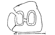
Outside the bank Jay the two-light window-head of red sand-stone-Fig. 29. This measures 16in. high by 18in. across the base, and from 5in., tapering upwards to 4in. thick. The round-headed opes measured 73 in. and 8 in. high by 4Y2 in. wide, and at the back 6Y and 7 in. by 3Y in. Each has a hole above and below by which to affix panes of glass ; these are set at about 2 in. from the face. Considering the small size of the building this probably formed a complete window, though it might have been the head of a two-light mullioned window, but the base has neither holes nor moulding or grooving, but has been dressed flat. A granite boulder, which, in connection with a larger building, might have been taken for a capital, appeared to be partly artificially rounded, and had a groove round the top. It measured 14 in. across the top by 12 in. high, and 9I2in. thick. A broken
slaty slab, ii by 8 by 1IZin. bore an inscription, H . . LIEETH AR. 1698. Another was of the 18th Century, but there could hardly have been burials here so recently, and with respect to the latter, we were told that it had been brought from the Parish Church when a new one was substituted for it.
Fig. 29. Window-head from Keeill at Ballavarkish, Bride.
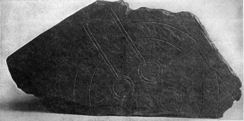
Fig. 30. Cross-slab from Keeill at Ballavarkish, Bride. Photograph by Mr. G. B. COWEN.
Fig. 31 tba
Inside the Keeill the broken upper-stone of a granite Quern was met with which had an original diameter of about 15 in., and was a in. thick. Lying by the stone, which looked like a door jamb, was a broken slab 23 in. by ao in. by i I2 in. thick. One face bears a well-drawn
Celtic cross and circle within a rectangular' panel.-Fig. 3o. The lines are worked with a smooth chisel, and both the circle connecting the limbs and the circular recesses are carefully draNLn with a pair of compasses, their centres marked by drilled holes. just above the centre is a name chiselled within a small rectangular panel, the corners of which are decorated with birds' heads. A flourish, looking like a mushroom drawn sideways, is followed by the word LUGRI. In the middle of the upper limb is another name also chiselled, and contained within a rectangular panel, which is not ornamented, viz : DIPRUI. The upper border of the same limb contains a third name, cut lightly, and not with a chisel, which readsCONDLLICI. There is yet another inscription on the upper band of the panel which encloses cross and circle. This is scratched, rather than cut, and some of the letters are not clear, but it appears to read-MAB [O] R [AI] SCRIBA + BRERB. . . . On this panel and on the cross are scratched several figures of crosslets and of animals. One just above the first name may, judging from its position and from the fact that a small crosslet is cut above it, be possibly the well-known sýmbol, the Agnus Dei ; if so, it is the first instance on our Manx Monuments. The others appear to be purely decorative, and resemble somewhat the figures scribbled in the margins of early Celtic MSS. In the first two names the letters consist of capitals and minuscules mixed, and show the period to have been that of the 7th or early 8th Century. The stone is flaked off a large slab, probably about 3 in. thick originally, but now unfortunately reduced to one. On the left edge there are three carefully-chiselled scores which have all the appearance of being the remains of an Ogam inscription, making, if that be so, another Bi-lingual in Celtic and Latin. Mrs. E. C. Farrant, the owner, has presented the window referred to as well as this monument to the Manx Museum and Ancient Monuments Trustees, who propose to have it set up along with the other Crosses from this Parish, in the Shelter at the Parish Church.
Some years ago Canon Savage found loose on this site a hollowed granite stone, about gin. diameter across the rounded base, and rather less across the top, the hollow scooped a few inches wide, and deep into the stone, which stands from 6 to 8 in. high. This he took to be a lamp adapted to a floating wick ; it is now in the Manx Museum, temporarily housed in. Castle Rushen.
In a field by the road to the house, at a spot 50 yards North-West of the Keeill, was a, Well known as Chibbyr-y-Varkish, which used to be visited for sore eyes and other complaints ; it has recently been drained and filled in. This Well must derive its name from the Keeill, and not from the Estate, as, though so close by, it is on the adjoining land of Ballacottier ; and this makes it the more likely that the Quarterland of Ballavarkish is not so called merely from the name of a one-time owner, but is also derived from the Keeill, which no doubt was dedicated to S. Mark. Below it at the roadside is a pool called Dem Varkish, but there appears to be no tradition about it. Some distance away on Lambhill estate, and about 6o yards W.S.W. of that house, is a more celebrated pool, known as Dem-ny-marroo, Pool of the dead. This lay on the old funeral road from Shellag to the site of what is now the Parish Church, and in passing it the funeral stopped, and the corpse was sprinkled with the water. We could not learn of any special reason for this, whether virtue lay in the water from some association with an early Celtic Saint, or whether the custom had been handed down from still earlier pagan times.
Ballacamain. This is marked on the O.S., III, 10, (1019). It lies about 700 yds. North-West of Ballachrink house and 700 yds. West of the highroad to Bride, at a height of too ft. or thereabouts. We regret that we were not allowed to examine it. From the appearance of the ground it seems doubtful if there is anything of the walls remaining, but we had hoped by excavating to have been able to judge the dimensions and possibly to have made a Plan. It is unfortunate that the superstition which prevents the orderly examination of some of these Keeills for the purpose of placing on record, for the information of those who come after us, such particulars as may still be gleaned of their character, structure and appearance, and of bringing to light any monuments buried in their ruins, has in no case availed to prevent their total ruin and subsequent destruction. These monuments and remains are all the evidence which has come down to us of the history of the people by whom they were erected, and of the conditions under which they lived, and even if the refusal to allow of their proper exploration were likely to preserve them, which it certainly is not, to keep them buried beneath the surface, and forbid their examination for the purpose of record, is as useless as to cart them away. We can only hope that in course of time, as the results of our work become better known, we may meet with more general support in this respect, and that a more active interest will be taken in the proper preservation of the little that does remain.
|
|
||
| |
||
|
|
||
| Any comments, errors
or omissions gratefully received The
Editor HTML Transcription © F.Coakley , 2006 |
||