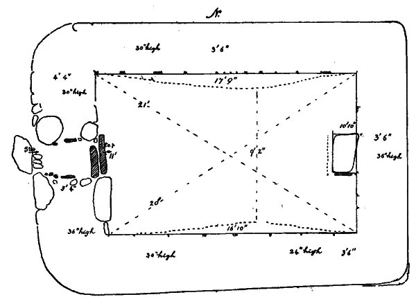
Fig. 21. Keeill at Knoc y Doonee, Andreas.
[From 3rd Report 1911]
In this Parish we have only been able after exhaustive inquiries to hear of four Keeills, and many must have disappeared long since.
1. Keeill on Knoc y doonee, Treen of Ballasteer.
2. Site of Keeill Tushtag, on Quarterland of Smeal, Treen of Smeal.
3. Site of Keeill on Ballagonnell, Treen of Ballamig.
4.. Site of Keeill on Ardonan, Treen of Regaby.
The Parish Church is probably an ancient site, though, from its dedication to S. Andrew, Mr. Moore thinks it is likely to date from the period of Scottish Rule, 1275-1334, (Manx Place Names, p. 213). But the seven Scandinavian cross-slabs found here bespeak a Church in the 1 i th Century; early graves also have been found which, from the number of Hiberno-Danish Coins met with, show that there were burials about the end of the loth Century ; and, in lgog a broken cross-head turned up which seems to date from the 9th Century. At about 8 yards in a line North of the West end of the Church is a cruciform stone with inscriptions of the 18th Century, which appears to have been an early Celtic Cross applied to secondary uses; and the building dedicated to S. Andrew was almost certainly preceded by a Celtic Church of which the name is lost.
Fig. 21. Keeill at Knoc y Doonee, Andreas.
O.S. V, 9, (2079). This small Keeill 200 yards E. S. E. of the house is set on a natural elevation in the field, about I9oft. above sea-level, and, when hidden under the growth of turf, suggested that more of the walls would be remaining than was found to be the case. Though disappointing in this respect it proved of the greatest interest in other ways. It was found to measure about I7ft. long by I ift. wide. The walls were built of shore-boulders, chiefly granite, those in the lower course being of good size and well-fittéd ; a section cut through the East end at the North corner, showed that they were formed by an inner and an outer face of stone, packed with sand and rubble. A large stone at the West end occupied almost the whole space from the South corner to the doorway, and measured 38in. long by 27in high and from Loin. to I4in. thick. Both North and South walls had settled with an inward bulge, reducing the width, at a point 6ft. from the East end, to 9ft. tin. ; the walls varied in width from aft. 3in. to Oft. 6in. at the West end, the doorway being 5ft. tin. ; they now stand from about 2ft. 6in. to aft. high from the foundations. Outside are remains of the usual embankment of earth and stone, the main purpose of which was probably to serve as a support, since walls so built must have been very liable to bulge in settlement. The doorway-Fig. 22, was in the middle of the West wall, Pin. wide inside, and about 28in. outside ; at a point about 2ft. 6in. from the inner face was a rebate of 6in. on the South side and one of about 4in. on the North, in which no doubt the door was set. Close by was found, loose, a worn socket-stone of a hard grey grit boulder 7in. square and 44in. thick, and another of red-sandstone i Tin. by g by 44in. was found further within the Keeill. The outer sill-stone was gone; outside was a pavement slab from which was a drop of Sin. to a cobble pavement occupying the narrower part of the doorway. The inner sill was formed by two slabs, one 28in. long by 6in. thick and high, the other 36in. long by 6in. wide and about Loin. high forming a step to the interior. On the South side, the inner jamb at the foundation was formed by the end of the large granite boulder, from which was sand and small boulders for 3oin., with one upright lining slab in position, I I by To by 2in., and an outer angular boulder I7in. by 3oin. and 24in. high, flat on the outside. The North side showed an inner and an outer boulder with sand and small boulders between, and a single lining stone on edge in the middle of the wider part. Around the rebate at either side were several small, long-shaped boulders set upright. The remains of the altar were found against the East wall. A heavy slab 25in. by 14 and Sin. thick, lying at a slight angle, was at first taken for the top, but as probably a sill-stone, slipped forward from the East window ; by picking with the greatest care at the loose stones, we finally revealed the undoubted top altar-slab, plain and undressed, measuring 2ft. gin. long by 2o to i Sin. wide, and from 22 to Sin. thick. This was found to be very carefully and neatly fitted to an upright slab on the South side, 2ft. gin. high, by i ft. wide, and an inch thick.-Fig. 23. The front and the North sideslabs had gone, the core was built up with boulders and sand showing a fairly even surface the front of which it was manifest had been faced by an upright slab from 3 to 4in. thick.-Fig. 24, This is of special interest as being our first example of an Altar so far perfect as to have its covering slab remaining in position on the top, and shows that the height, in this instance at all events, was not more than 24in. above the pavement which appeared to have been formed by small cobble-stones. It is of course possible that a small consecrated portable Altar would be brought by the Priest and laid upon this stone, but even so that would not add more than two or three inches to its height. The total size of the Altar must have been about 33in. by 17in., and 24in. high. By probing, we found there was nothing below it. Trenches were dug, but there was no certain evidence of a grave within the Keeill, though some black unctuous matter, met. with below the floor near the East end, was almost certainly the remains of a burial there. Over a hundred white shore pebbles were met with, mostly about the Altar, and among these were several worked flints which, as well as some small flint boulders, might have been cast into the graves with the pebbles. The floor pavement had gone, excepting in the door-way and about the Altar. The upper stone, broken, of a granite Quern was found loose among the rubbish, 18in. diameter (which was the full original size), by Sin. thick ; also a lower stone, broken in half, of another quern and fragment of another upper stone (about 16in. diameter originally).
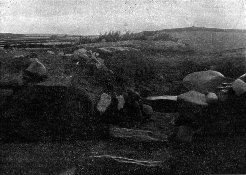
Fig. 22. Doorway, Knoc y Doonee, from the inside. Photograph by Mr. G. B. COWEN.
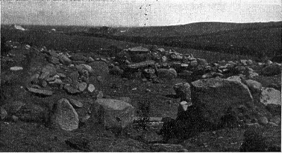
Fig. 23. View of Keeill at Knoc y Doonee from the West. Photograph by Mr. H. C. BAILEY.
Among the loose stones thrown out of the Keeill, Mr. Martin noticed one which was carved ; this was a boulder of a reddish trap-rock, Bin. long, broken at one end, by 61in. wide and 2 to Sin. thick, fairly flat; on the smooth face is a plain Latin Cross worked with a pick or pointed chisel in outline, the limbs surrounded by an elliptic ring; the lines are not joined at the middle or at the ends. The remaining end shows two lines radiating outwards from the ends of the ring no doubt balanced by other two at the other end. One limb has a short line at right angles on either side The curve of the elliptic ring shows that the broken limb must have been at least i' in. longer, and the slab may have extended beyond it for another three or four inches, giving a total original length of about 1 Sin.-Fig. 25.
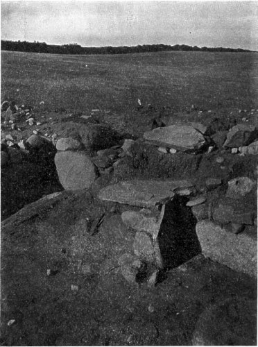
Fig. 24. Enlarged View of Altar, Knoc y Doonee. Photograph by Mr. G. B. COWEN.
But our great discovery, the most important made by the Survey, was that of a Bi-lingual Inscription belonging to a, class of monuments, very limited in number, which is practically peculiar to South Wales, with one or two examples in Cornwall and Devon. A few feet to the West of the Keeill was a heavy slab set up and looking like an old gravestone. At our request Mr. Martin had this taken up for examination, and it was found to bear across the face a three-line inscription in Latin, and up the left edge a Celtic inscription in Ogam characters. Fig. 26. The pillar measures 5 ft. gin. by 17 to 10 in wide and from 8 to 7 in. thick, and must have been brought at considerable labour from the hills about Sulby, some six miles to the East.
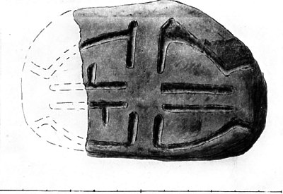
Fig. 25. Cross-slab from Keeill at Knoc y Doonee, Andreas. Drawing to Scale,
P.M.C.K.
Evidently it had at one time fallen and been set up again with the upper end downwards, thus preserving the inscription from further injury. The faces had not been dressed, but the sides from a point- about 24in. from the bottom- had been worked to a round ; one of these is now flaked off; the other bears the inscription of which the first two characters and some of the vowels had weathered away ; the rest is perfectly clear and reads-. . B . CATOS MAQI ROCATOS.-Fig. 26. The Latin inscription across the face is in well-formed Roman capitals, a few letters blurred by weathered cracks, but quite legible
AMMECAT°
FiLIVS ROCAT
HIC IACIT.
i.e. Ammecatus son of Rocatus lies here ; the Celtic inscription being as is usual an echo of it,---(The Stone) of Ambecat son of Rocat. Lower down on the edge of the same side are some fine scores upon that portion which must originally have been buried in the ground, evidently scratched on it after it had been turned round and set up again. They are certainly not Ogams, and probably were simple scores to serve as a tally of loads carted on or off the field at some recent time. Upon digging at the spot where the stone had been set up, we found, at a depth of 3 ft. 3 in. from the surface, loose, fine, dark soil with black unctuous matter which must have been the remains of a burial. but no lintels or stones ; at a further depth of three or four inches the undisturbed yellow sand was reached. This is the only Bi-lingual yet discovered in the Island, and adds another type to the wonderful collection of inscribed monuments met with in Man. In excavating the bank against the East gable, Mr. Martin found a piece of bronze 7 in. by 5½in., which turns out to be a fragment of a Caldron or Skillet, of the 17th Century, originally about 7½ in. high and 6½ in. diam. across the mouth : also a bronze shoe-buckle, 2¾by 2¼in., plain. Mr. Martin, who personally assisted us in our excavations, has generously presented the pillar, as well as the small Cross-slab, to the Manx Museum and they are now placed temporarily in Castle Rushen.
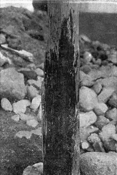
Fig. 26. The Knoc y Doonee Pillar. Ogam Inscription. Photograph by Mr. G. B.
COWEN.
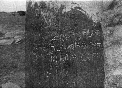
Fig. 27. The Knoc y Doonee Pillar. Latin Inscription. Photograph by Mr. G. B.
COWEN.
O.S., III, 5, (701), on the crest of the hill, looking South over the Andreas plain, at a, height above sea-level of about,, 240 ft. The site of the Keeill is about 666 yds. South of the house and about the same distance North of Lough Drughaig ; on the O.S. the enclosure measures about ioo ft. diam. Some years ago the last remains of the walls were removed by the owner, Mr. T. Corlett. About 233 yds. South of the Keeill is a Well which was visited by patients "when the Books were open," i.e. during Divine Service.
At a corner formed by the boundary fences of the three Quarterlands of Keeill Tushtag, Braust and Ballaquane, was a " Fairy-hole, " or hollow in the top of the earthen embankment, about 12 in. diam. We were told that " any one wanting a cure would put in a stone with a spit," the object no doubt being to identify it more particularly with his own person, so that his own malady or affliction should pass into it. That this was so, and that the malady was capable of being conveyed to another, is made clear by the fact that our informant's father had once taken one of the stones out of the Fairy Hole and become very ill ; he did not recover till he had returned it. On the same hill, about 133 yds. N.W. of the Keeill, Urns have been found,
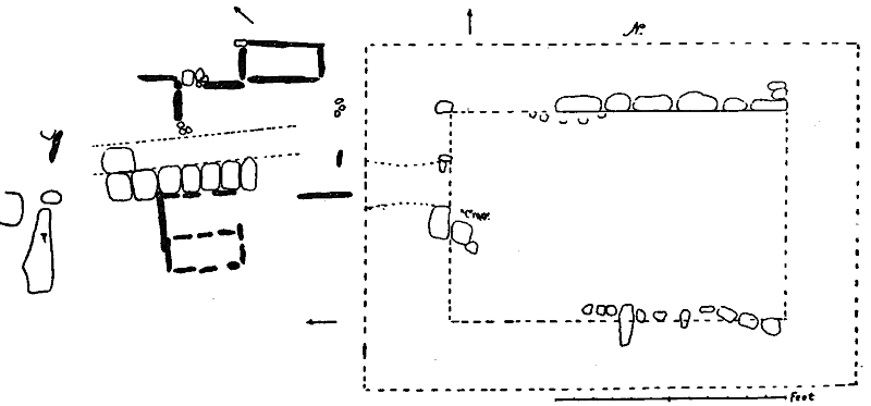
Fig. 28. Keeill at Ballavarkish, Bride.
A Keeill is remembered to have been on Ballagonnell by the side of the highroad leading from the Lhen, and about 50 yards N. W. of the house, at a height above the sea of 8oft. It is not marked on the O.S., butwould be 11, 12, (855), and is generally known as "the Cabbala" Large stones from it were carted to his house about 1865 by the owner, Mr. John Corlett, who shortly afterwards died suddenly. His son had the stones sent to the Parish Church, where they were built into the Tower, many of them making good cornerstones. A broken "Font" is remembered to have been sent with the stones to the Church, and there were also many "Beads," which unfortunately have now been lost. The Rev. F. Lamothe presented one to the Museum.
This is not marked on the O.S., but should appear on V, 1, (2631): At the S.E. corner of the Parish where it bounds with Lezayre, a natural hill of sand and gravel, loo yards E.S.E. of the old house, rising some 5o ft. above sea-level, and conspicuous above the low meadow-land to the South and West, retains in its name the memory of this Keeill, being known as Cronk Keeill Traie, Hill of the Keeill by the Strand. That there was a considerable amount of water here in historical times is shown by the names of two of the meadows below the Cronk-Lough eer and Lough ar, East lake and West lake. It has long been ploughed over, and we could learn no particulars of it, except that in Cronkbreck house, close by, is a stone taken from its Burial-ground. The dedication is lost, but may perhaps be traced in the name of the Quarterland on which it stands, that of Ardonan, or Onan's height, applied in the first instance to this Cronk from the fact that the Keeill upon it was dedicated to Adamnan, the pronunciation of which name became corrupted both in Ireland and Scotland to Onan. This would doubtless refer to the distinguished Abbot of Iona, a successor of Columba, and best known as his biographer, whose name also is invoked in the Runic Inscription discovered at Cornaa in Maughold. Manx Crosses, No. 114.
|
|
||
| |
Andreas | |
|
|
||
| Any comments, errors
or omissions gratefully received The
Editor HTML Transcription © F.Coakley , 2006 |
||