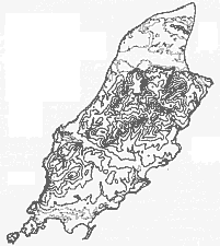
FIG. I.--The Relief of the Isle of Man.
The lowest contour (50 ft.) is a pecked line ; other contours at 100 ft. intervals.
[From Land of Britain, part 44, 1941]
THE Isle of Man consists essentially of a central mountain mass built of grey or blue slates, flags and grits of Upper Cambrian Age striking north-east to south-west and occupying three- quarters of the area of the whole island. These Manx Slates are much disturbed and are traversed by numerous igneous dykes both basic and acid. Two large outcrops of granite occur at Granite Mountain at the head of Foxdale and at Sheau Ruy north of Laxey and most of the productive metalliferous veins in the island are located near these two granitic areas. The highlands are divided into a northern and a southern mass by a transverse central valley, narrowest in the line of the mountain axis but widening coastwards along the valleys of the Neb and Dhoo rivers flowing to Peel and Douglas respectively. The hills of the uplands are steep-sided but gently rounded and smooth, and are arranged in long ridges, running in the direction of the longer axis of the island, separated by broad high valleys. The most prominent of these axial ridges can be traced from near Ramsey and is practically continuous through the length of the island to the south-west coast north of Port Erin. It begins in North Barrule and continues throughClagh Ouyr to Snaefell where the Manx massif attains its highest point, 2,034 feet. From Snaefell this eastern ridge continues through Mullagh Ouyr, Beinn y Phott, Carraghan, Colden, Lhargee Ruy, and Slieau Ruy to Greeba. Here this line of heights is truncated by the central valley but beyond this the ridge continues from South Barrule to Cronk ny Irree Lhaa. A western ridge, on the whole of rather lower elevation, can be traced from Mount Karrin through Slieau Carn, Slieau Dhoo, Slieau Freoghane and Sartfell to Beary Mountain ; beyond the central valley this ridge is continued in Slieau Whallian and Dalby Mountain to Cronk ny Irree Lhaa where the eastern and western ridges meet. Here the upland becomes broken up and descends gradually towards the sea at Spanish Head.
FIG. I.--The Relief of the Isle of Man.
The lowest contour (50 ft.) is a pecked line ; other contours at 100 ft. intervals.
The flatness and coincidence of the altitudes of the ridges whose summits range between 1,300 and 1,800 feet suggests that they are the remnants of a former peneplane out of which the existing valley system has been carved.
From Snaefell there is a simple radial drainage following steep narrow valleys to the sea. Draining to the north are the Sulby and Glen Auldyn ; the Cornah and Laxey flow to the east, the Glass and Baldwin drain south-eastwards and the Neb flows south-west to the central valley.
The mountains to the south of the central valley have developed their own drainage pattern which radiates from a centre in South Barrule and Cronk ny Irree Lhaa. From here flow Glen Rushen waters to the north and north-west, the Foxdale flows north and the Santon, Silverburn and Colby streams drain to the south in shallow open valleys contrasting with the deep walled glens of the majority of Manx mountain streams.
The topography in the mountain masses is gently rounded and smooth except where the mountain streams have entrenched themselves in the bottom of the broad and rather shallow high valleys during a second phase of erosion.
The central upland is bordered on its east and west flanks by narrow coastal plateaus. That on the west side is the narrower of the two and rarely exceeds 6oo feet in altitude. Starting at Ballaugh the coastal plateau is about a mile wide but south from here it narrows gradually until south of Peel it is scarcely half a mile wide. South of the central valley the plateau rapidly diminishes into a narrow coastal strip and finally south of Dalby passes into the cliff edge forming the seaward slope of Cronk ny Irree Lhaa.
On the eastern side of the highlands the spurs of the mountains have a gradual slope to the coastal plateau which is rather lower and wider than that on the west coast. About one and a half miles wide in Maughold, it gradually widens towards the south and finally opens into the plain of Malew centring on the Carboniferous basin of Castletown. In the east and south-east the glens are more numerous but broader than on the west coast and are little more than the continuation of the slopes of the hills above. On the west coast the fewer glens are steeper and characteristically of gorge form and there is a more abrupt transition from coastal plateau to mountain.
There are three relatively low-lying areas which stand out as being distinct from the Manx massif and its plateau fringe-the Northern Lowland, the Plain of Malew and the Peel Sand- stone area.
The solid massif of the northern uplands terminates abruptly along an east-west line which bears no relation to any known structural feature of the rocks ; the steep slopes leading down to the northern plain have evidently once formed a cliffed coastline rising above the platform of marine erosion now buried beneath the glacial and alluvial deposits of the Northern plain. The Northern Lowlands form a well-defined region comprising about one-fifth of the island's total area, and except on this northern plain there is little flat ground in the island. It is composed of glacial drift and alluvium resting on a floor of Triassic, Permian and Lower Carboniferous rocks. The least elevated parts of the plain are to be found immediately under the northern border of the uplands. Here lie the Curraghs, old marshy areas now drained but still wet. Situated between the edge of the massif and the gravel platforms of the parishes of Jurby, Andreas and Bride, the Curraghs occupy the sites of glacial lakes fed by streams from the hills and hemmed in by a high rim of drift around the depression. In its earliest stages about the close of the glacial period the whole depression was probably filled by one continuous lake. Later the water level was lowered by the erosion of drainage channels through the drift barrier and at least three separate basins at different levels were revealed, falling to the east and more or less separated from each other by ridges of dry land of late glacial flood gravels. The three main basins to-day are
(1) Ballaugh Curragh in the west between the gravel extending between Glen Dhoo and Killane River and the gravel spur past the Rule and Close e Volley to the mouth of Sulby Glen.
(2) Sulby Curragh which lies between the last-mentioned gravel ridge and the road across the Curragh from Sulby Bridge to St. Judes where a peninsula of gravel and islands of dry sandy ground form an irregular barrier separating this Curragh from the
(3) Lezayre Curragh.
The Ballaugh and Sulby Curraghs are generally about 36 feet to 40 feet above sea level but the Lezayre Curragh rarely exceeds 18 feet to 25 feet.
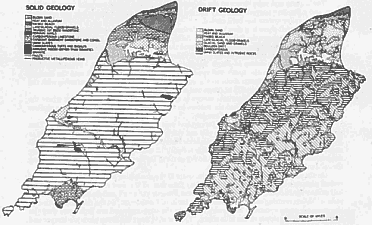
FIGS. 2 and 3.-The Solid and Drift Geology of the Isle of Man.
The infilling of the glacial lakes has produced a peat and peaty-sand of considerable thick- ness in the Curraghs. The precise extent of the former Curragh lakes is now somewhat uncertain but three are shown in old maps of the Isle of Man as late as 1673. One is to the west of Andreas draining to the Lhen and seems to have been an extension of the present Laghagh Mooar ; a second named Balla Lough to the north of Ballaugh drained by the Killane River ; the third Malar Lough between Lezayre and Andreas drained into the Sulby River and thence to the east coast at Ramsey. The imperfections in the old maps make these localities difficult to identify but the second and third probably occupied the west and east portions of the Curragh. These formerly extensive marsh areas with lakes and islets were drained mainly in the seventeenth and eighteenth centuries and became damp meadow land. Only occasional patches of marsh and unreclaimed land still exist.
From the Curraghs the lowland rises in a series of broad shallow sand and gravel platforms to a line of morainic hills. The sloping platforms have terrace-like edges and are furrowed by drainage channels, now for the greater part dry or occupied by lines of artificial drainage. The platform of Jurbv has its north-western boundary along the coast from the Killane river to the Lhen outlet and is bounded on the east by the Lhen. Its southern edge, presenting a scarp above the late glacial flood gravels, is marked by a line of farms-Ballateare, Ballavaan, Ballavarran, Ballamoar and Ballameanagh--where the water of the platform gravels is given out against the underlying clay. On the platform of Jurby the gravels are coarse and thick in the west but thin out towards the east. The Andreas platform extends from the Lhen to the east coast and descends from loo feet near the Bride Hills to 30 feet along the margins of the Curragh but the terrace edges which are distinct near the east coast soon become lost and the gravel slopes gently in the vest to an ill-defined marshy region.
The Andreas platform carries a large area of boulder drift which occurs as an arcuate belt, varying in width from 1/4 mile to one mile, extending from the Curragh border near St. Judes, through Andreas to Blue Point, and as an arc half a mile wide from Ballalheaney to Ballavair in Bride.
The gravel platforms rise to and are bordered on the north by the inner or concave side of a crescentic line of morainic hills, the Bride Hills, so-called because they attain their greatest development (300 feet) around Bride village. The eastern horn of the crescent of sand and gravel mounds is truncated by the sea at Shellag Point ; from here the morainic hills continue westwards for 12 miles through Jurby to the west coast in a crescent rarely exceeding half a mile in width. The line of hills finally abuts on the central massif south of Ballaugh village. The hills consist of stratified drift--coarse current bedded boulder gravel, fine shelly gravel, sand and clay, and contain many deep valleys, some of which traverse their entire breadth. These are the beds of glacial watercourses and are related to the gravel platforms which lie south of the moraine. The morainic hills terminate sharply northwards along an ancient cliff some 5o feet high, cut in the glacial drift. At the foot of this cliff lies a raised beach, ro feet to 15 feet above high- water mark and one mile wide at the Point of Ayre but narrowing gradually westward until at the Lhen it is a single storm beach. The Ayre is a barren strip of shingle ridges covered in places inland with low dunes of blown sand. Along the inner border the blown sand has been rendered cultivable by mixing it with clay from the adjacent cliff cut in the morainic drift but settlement does not extend beyond the drift itself.
The two other regions which stand out as distinct from the rest of the island are
(1) The south-east lowland centring on the Carboniferous basin of Malew.
(2) The red sandstone area around Peel.
The plain of Malew has as its nucleus the roughly oblong basin of Lower Carboniferous rocks with the longest diameter lying north-east-south-west parallel, to the mountain axis of the island. The rocks are cut off on the north-west by a fault from Strandhall north-east to Ballashimmin. On the north-east the Carboniferous limestone is bordered by a belt of Basement Conglomerate which extends along the margin of the Manx Slate series. The south-east part of the Carboni- ferous basin is covered with sand and gravel occurring as platforms. North-west the gravel platforms are replaced by boulder drift series from Ballashimmin to Cass ny Hawin. The Carboniferous limestone series which occupies an area of some 7 to 8 square miles consists of a succession of low domes and shallow basins giving a low-lying, gently undulating tract. This small tract of limestone has received notice in most of the old topographical descriptions on account of its economic importance in a country so generally devoid of calcareous rocks ; the quarries in this rock have been the chief source of lime in the island. The plain of Malew extends beyond the limits of the Carboniferous rocks on to the bordering Manx Slate series and an extension of this plain runs westwards through Rushen, on the sand and gravel platforms flanking the southern slopes of the southern mountain massif, to the west coast at Port Erin.
The narrow strip of red sandstone which borders the coast for about i 4 miles north of Peel and which varies from a mile to half a mile in width may be considered as the nucleus of a third relatively low-lying area which stands out as being rather distinct from the plateau fringes of the Manx massif. The sandstones have given rise to a small triangle of about 4 square miles of relatively low-lying land, the topography of which is distinct from that of the surrounding countryside. The region is surrounded everywhere inland by high ground except along the line of the central valley; its smooth rolling landscape slopes gently seawards where it terminates in steep cliffs of 5o to 6o feet. The sandstone is overlain by glacial sands and gravels arranged in mounds.
Adjacent to the main island but separated from the south-west end by the Sound, half a mile wide, is the Calf of Man. This is a plateau of about Boo acres with precipitous crags all round and similar topographically to the Mull Hill upland area which is separated from the main mass of the southern mountains by the plain behind Port Erin.
Glacial deposits are the chief factors in determining the character of the soil in the island. The high level drifts which almost entirely cover the Manx massif are formed of local Manx Slate series material and occur as bluish-grey till full of local stones or as a loose slaty rubble. The soil which has developed from this on the hill slopes and in the shallow depressions around the heads of streams is thin and stony. In the high valley bottoms the drift is often deep but is again coarse and stony. The steep floored and steep sided glens are usually choked with drift and on the detritus-filled valley floors there are often mossy bogs. This same local drift provides the cover also for the east and west flanking plateaus and the central valley.
The soils of the northern lowland developed on the extra-insular drift are variable, ranging from stiff clay to light sand and gravel with patches of peat in hollows. The boulder clay has usually a sufficient admixture of sand to form a loamy topsoil. Formerly the lighter sandy tracts were " marled " with boulder clay or stratified glacial clay to give a soil consistency favourable to wheat production. Although this practice is now abandoned the northern plain has many ponds occupying the sites of old marl pits.
The south-eastern part of the Carboniferous basin of Malew is covered with sand and gravel occurring as platforms. To the north-west the gravel platforms are replaced by boulder drift. The lower parts of the southern lowlands overlying the Carboniferous rocks and extending beyond them up the gentle slopes of the slates to 6oo feet have soils similar to those of the northern lowland but with less sand and gravel and more loam, while the boulder clay soils are tougher, heavier and more calcareous. On the higher ground, where the drift is mainly derived from local slate, the boulder clay is deep and stony with fragments of slate but lighter and more loamy than on the lower portions of the Malew lowland. Soil consisting of this loose slaty debris derived either from subjacent decomposed rock surfaces or from slaty drift of a gravelly type predominate all over the hilly tracts while higher still the soil becomes thinner and more rubbly. Lime of good quality was formerly sent from this region over the whole island for agricultural purposes. The sandstone of the Peel lowland area is overlain by glacial sands and gravels which give a generally light or loamy soil.
No part of the Isle of Man is more than five miles from the sea and because of its small size the climatic conditions in all parts of the island are essentially the same, such variations as do exist being modifications due to the influence of local topography. Some references to the significance of wind will be given later (p. 18). The statistics have in general been taken from the publications of the Meteorological Office.
The prevalent winds are westerly or south-westerly from across the Irish Sea and this marine influence exercises a moderating effect on temperatures throughout the island and at all seasons of the year. Records of monthly maxima, minima and mean temperatures are available only for Douglas but since there are no great temperature differences within the island the significant features of this element of the climate may be fairly illustrated by the Douglas records. These figures show remarkably equable temperatures with an annual mean of 48-6° F., and a mean annual range of only 16-9° F. The temperature variations about the monthly means are also small, being about ±5° F. for all months of the year.
DOUGLAS, ISLE OF MAN
54 10' N. ; 4° 28' W., 284 feet. 1906-20; 1926-35
|
Average Daily |
Average Daily |
||
|
Maximum |
Minimum |
Mean |
|
|
9-9 |
9-9 |
||
|
°F. |
°F. |
°F. |
|
|
January |
45•2 |
37•7 |
41•5 |
|
February . |
44•8 |
37•0 |
40•9 |
|
March |
46•6 |
37•3 |
41•9 |
|
April. |
50•6 |
39•'8 |
45•2 |
|
May |
56•2 |
44•7 |
50•5 |
|
June . |
60•4 |
48•9 |
54•7 |
|
July |
63•0 |
52•3 |
57•7 |
|
August |
63•0 |
52•6 |
57•8 |
|
September |
59•9 |
50•0 |
54•9 |
|
October |
54•4 |
45•9 |
50•1 |
|
November |
49•1 |
41•1 |
45•1 |
| .December . | 46•1 | 39•0 | 42•5 |
|
Year |
53•3 |
43•9 |
48•6 |
July and August are the hottest months with mean temperatures of nearly 58° F., the mean maximum for these months being 63° F. and the mean minima 52.30 F. and 52.6° F. respectively. The coldest months are January, February and March, the lowest mean temperatures being experienced in February, but it is notable that the mean temperature of each of these months is above 40° F. It will be noticed that spring is rather cold with mean temperatures of 45° F. in April, 5o° F. in May and 55° F. in June.
No month has a mean temperature below 40° F., and frosts are neither severe nor continuous. Snow is most frequent in winter (January to March) but the falls are slight and of short duration.
|
AVERAGE NUMBER OFan. Feb. Mar. Apl. ~ May une |
DAYS WITH SNOW (iMi-IgI5),duly Aug. Sept. Oct. Nov. I Dec. Year |
||||||||||
|
4 |
4 |
4 |
1 |
011 |
010/ |
010 |
0*0 010 |
0*3 |
1 |
2 |
16'7 |
In general the temperature of the Isle of Man is decidedly equable and is distinguished by cold springs, cool summers and mild autumns and winters.
The mildness of the winter season finds one expression in the vegetation of the island- fuchsia grows well and palms are common ornamental trees in the open.
Whereas temperature figures are fairly uniform over the whole island except where modified by altitude, the average annual rainfall varies considerably according to location. It i s not possible to provide an accurate detailed account of the variation of rainfall within the island because the necessary statistical data are lacking. Only seven rainfall recording stations are maintained and these are not well distributed. Data for the northern plain are provided by three stations-the Point of Ayre, Ramsey (Town Hall) and Ramsey (North Promenade). The other four stations are either on or near the east coast, two being at Douglas (Town Hall and Onchan), one at the West Baldwin Reservoir and one at Maughold Head.
The main features of the distribution of the average annual rainfall are explained by the position of the mountain axis of the island in relation to the prevalent westerly or south-westerly moist winds. The northern plain, the southern lowlands and the west coast are the driest areas with a mean annual precipitation of 30 to 40 inches. The Manx highlands south of the central valley, the lower slopes of the northern mountains and the adjacent districts on the east coast from Ramsey to Douglas receive a heavier mean annual precipitation of 40 to 5o inches. The highest parts of the northern mountain mass round Snaefell and its neighbouring heights show their influence as producers of orographic rain and receive a mean annual rainfall varying from 5o to over 6o inches.
Although the amounts vary from place to place in the island the seasonal distribution of the rainfall is similar throughout the island. The rainfall statistics for Douglas appended below show that the rain is well-distributed throughout the year with an autumn maximum in October, November and December when cyclonic activity is greatest, and a spring minimum in April, May and June when high pressures to the north of the British Isles are liable to become estab- lished. Rains are frequent and the average annual number of days with rain reaches the high figure of 204. The figures for the average number of days of rain for each month are given in the following table.
|
Average rainfall(inches) |
No. of rain days |
|
|
January. |
3•35 |
20 |
|
February |
3•18 |
18 |
|
March . |
2•83 |
18 |
|
April |
2•41 |
16 |
|
May |
2•50 |
15 |
|
June |
2•42 |
13 |
|
July |
3•06 |
14 |
|
August |
3•81 |
17 |
|
September |
3•25 |
14 |
|
October |
4•55 |
19 |
|
November |
4•69 |
9 |
|
December . |
4•94 |
21 |
|
Total |
40•99 |
I _ ...Zoo_ |

FIG- 4.-The Average Annual Rainfall of the Isle of Man.
(Map supplied by the Air Ministry, Meteorological Office, British Rainfall Organisation).
Of great significance from the agricultural standpoint is the variability of the rainfall Variations in the rainfall will affect different parts of the island in different ways. Soils of the sandy type are not retentive of moisture and in drier years the deficiency of moisture is also serious to the agriculturalist on the soil developed on loose, slaty debris. The heavier boulder
clay soils on the other hand suffer most in wet seasons. As an example of the magnitude of the variation from the normal which may occur the rainfall statistics for 1938 may be quoted.
|
1938 MONTHLY RAINFALL |
|||||||||||||
|
_7an. |
Feb. |
Mar. |
April | May |
June ) . |
July | Aug |
Sept. |
Oct. |
Nov. |
Dec. |
||
|
Douglas |
5-16 |
1-62 |
1-88 |
'41 | 5-08 |
5'97 |
5'27 |
2'17 |
3'32 |
9'00 |
5'31 |
4'30 |
49'49 |
|
Departure from normal |
+1.81 |
-1-56 |
-'95 |
-2'0 |
+2*58 |
+3'55 |
+2'21 -1'64 |
_j-*07 |
+4'45 |
+'62 |
-'64 |
+8*50 |
|
Notwithstanding the prevalence of moist westerly winds and an abundant and frequent rainfall the island has the high average of 4'3 hours for the mean daily duration of bright sun- shine. The appended table shows the total number of hours, the daily mean duration of sun- shine and the percentage of the possible sunshine for each month in the year for Douglas.
|
Average total |
|||
|
Bright Sunshine |
Daily Mean |
per cent. of possible |
|
|
(hours) |
|
||
|
January |
522.7 |
1'7 |
21 |
|
February . |
674.9 |
2'4 |
25 |
|
March |
1289.6 |
4'2 |
35 |
|
April. |
1756.2 |
5*9 |
42 |
|
May . |
20228 |
6-5 |
41 |
|
June . |
215'79 |
7'2 |
42 |
|
July |
19785 |
6'4 |
38 |
|
August |
171'50 |
5'5 |
37 |
|
September |
151 -6o |
5-1 |
40 |
|
October |
100-16 |
3*2 |
31 |
|
November . |
65'53 |
2'2 |
26 |
|
December . |
4262 |
1.4 |
19 |
|
Total |
1571-67 |
4'3 |
35 |
|
|
||
| |
||
|
|
||
| Any comments, errors
or omissions gratefully received The
Editor HTML Transcription © F.Coakley , 2007 |
||