[From Land of Britain, part 44, 1941]
EVEN a cursory examination of the Land Utilisation map of the Isle of Man reveals a distribution pattern for arable land which is striking both on account of the solidity and continuity of the large area of the island under cultivation and the sharpness of the division between this and the other utilisations.
The general aspect of the island is that of a skirt of cultivated fields, extending from the coast on to the coastal plateaus, along the glens and the central valley and up the lower hill slopes of the mountains to an average elevation of 650 feet above sea level. Somewhere about this height in all parts of the island there is a sharp limit to cultivation and an abrupt change from arable to rough mountain pastures. The influence of topography on this distribution is evident. The slopes of North Barrule continuing through Slieau Lewaigue bring the Manx mountains right to the coast immediately south of Ramsey but southward from here on the eastern flank of the island there is more or less cultivation on the hill slopes from end to end. In the stretch between Maughold Head and Onchan Head the arable belt is narrower and arable fields are more scattered than elsewhere in the island. This is a reflection both of the narrowness of the coastal plateau here and of the poor quality of the stony slaty drift which covers the plateau. Where the eastern slopes of Slieau Ruy come down to the coast between Bulgham Bay and Port Corna the mountains are built up of Dhoon granite; the high relief and poor soil covering the granite have carried a belt of poor pasture across the coastal plateau and separate the Maughold arable area from that extending from Laxey through Lonan to Onchan.
Behind Douglas the lowland of the central valley and the lower parts of the adjacent slopes of the northern and southern mountains allow a much more extensive development of the arable area. Extending in a broad crescent round Douglas from Onchan to Port Soderick it is limited to the west where the axial range crosses and narrows the central valley.
This arable area in the eastern half of the central valley continues to the south over the shoulders of Slieau Chiarn, the Mount and their continuations in the higher land which forms the southern rim of the valley, to widen into the extensive and solidly arable region developed on the limestone basin of Malew. The southern arable area is not confined to the limestone district but extends beyond this on to the hill slopes of the southern mountains where the greater part of the drift-covered area up to an average height of 650 feet is tilled. A second extension is westward to Port Erin and the arable here follows the sand and gravel platforms between the coast and the slopes of the southern mountains.
On the western side of the island the cultivated strip flanks the Manx mountain mass and extends inland for an average distance of two miles from the coast. As we trace the west coast arable from south to north it is found first at Dalby where the high and steep seaward slopes of Lhaitee ny Beinee and Cronk ny Irree Lhaa are replaced by the west coastal plateau. As this plateau widens northward so does the extent of the arable area which attains a width of some three miles where it includes the Peel sandstone area. A narrow extension of arable land along the central valley between the near-by approaching slopes of Beary and Slieau Whallian continues the Peel arable into the central arable region which occupies the slopes leading to Foxdale and the central valley from Slieau Whallian, South Barrule, Granite Mountain, Archallagan, Beary and Greeba.
Northward from the Peel lowland, between Knocksharry and Kirkmichael the west coast arable belt is patchier. It is in just this stretch that the Manx Slates form the solid geology and the soil covering is of local boulder drift derived from the subjacent slates and grits. Where the slates have resulted in slopes too steep for cultivation and the boulder drift has provided a ground too stony or too badly drained to encourage cultivation, the land is left as permanent pasture or rough pasture. The arable land here is found on the flatter, better drained plateau tops and the gentler slopes.
Beyond Kirkmichael the glacial sands and gravels have provided a basis for a solidly arable tract which passes northward through Ballaugh to the well-cultivated northern plain. In the Northern Plain again is demonstrated that intimate correlation between geology and topography and the distribution of arable land which is such a clear feature of the land utilisation in the Isle of Man. The pattern of the arable land distribution is strikingly correlated with the distribution of glacial sands and gravels and is just as clearly and significantly absent from the wet alluvium of the Curraghs.
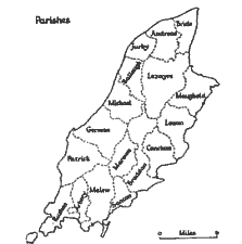
Fig. 5.-Map showing the Parishes of the Isle of Man, for identification.
For an island not notably fertile and with mountains occupying over half the surface there seems to be a surprisingly small proportion of the land under permanent pasture. The statistics published by the Ministry of Agriculture reveal a position essentially the same as that shown by the Land Utilisation map. Although the figures vary from year to year there are on the average about 20,000 to 23,000 acres of permanent grass and 52,000 to 58,000 acres of arable land, i.e. permanent grass occupies an area only two-fifths that of the area under arable crops. In the island there is a proportion of arable to permanent grass which is much higher than anywhere on the mainland of England and Wales with the exception of some of the eastern counties. The distribution of permanent grassland is partly to be explained by less fertile and less accessible land having been left as permanent grass but the proportion and distribution of grassland are not to be explained solely by reference to geology, topography or soils ; a recognition of the special nature of Manx agriculture and the working of certain important economic factors in shaping the farming economy, is essential to the understanding of these proportions and distributions, but a discussion of these matters must be left to a later section.
The most extensive area of permanent pasture is to be found in the Curraghs of the northern plain and for this there is a definite topographical basis. The Curraghs occupy the sites of former glacial lakes which have been infilled to produce extensive marshy areas. In the seventeenth and eighteenth centuries these were drained to damp meadow-land and are to-day very wet areas so that although used for pasture land they are not heavily stocked. The Land Utilisation map shows very distinctly the three incompletely separated pasture areas coinciding very closely with the extent of the alluvium of the Curraghs of Ballaugh, Sulby and Lezayre. Along the Lhen, the drainage channel from the glacial lakes and the present-day drainage channel from the Curraghs, the narrow ribbon of alluvium carries a ribbon of pasture land from the Curraghs to the coast.
Apart from the Curraghs the northern plain has no large area of permanent grass. The scattered patches to the east of the Lhen are for the most part concentrated on the boulder drift of the Andreas platform. This extends from south to north in a belt about a mile wide from the Curragh border near St. Judes, through Andreas to Smeale and Ballabane. A second concentration of permanent grass is on the patch of boulder drift which occurs as an arc half a mile wide extending from Ballalheaney to Ballavair in Bride.
Around the eastern edge of the northern mountains a belt of permanent grass frequently separates the arable land of the lower slopes from the rough grazing of the higher mountain pastures and also occasionally replaces the arable land altogether on the lower slopes. This is a reflection of the generally steep eastern slopes of the mountains and the thin stony soil cover which made cultivation unprofitable even at low elevations in many cases, therefore the land is best left as permanent grass. This is in marked contrast with conditions on the western edge of the northern highlands where cultivation has been pushed up the hill sides on these gentler western slopes and better soil covering to an average height of 650 feet above sea level. Beyond the limit of arable land there is an abrupt change in the land utilisation and immediately the rough mountain pastures are met, without any intermediate zone of permanent grass. The permanent grass of the west coast is located for the most part on the platform between Knocksharry and Glen Mooar, i.e., in just that section where the Manx Slate series and glacial boulder drift form the surface rock. Within this region the permanent grass is found mostly on the glen and valley sides which are too steep for cultivation and also where the boulder drift on the plateau is too stony for cultivation. It is significant that to the south of Knocksharry and to the north of Glen Mooar, where the surface materials are glacial sands and gravels, the occurrence of permanent grass is much rarer. Within the northern mountains the only significant occurrence of permanent grass is to be found around the head of Sulby Glen. It is on the gentler slopes of the glen sides above the very steep glen bottom. Formerly an arable region, the lands have been converted to permanent grassland with the abandonment of the farms.
A zone of permanent grass embraces Douglas and extends in a crescent half a mile to threequarters of a mile wide from Onchan Head to Douglas Head. The two extremities occupy outcrops of the hard Lonan flags, part of the Manx Slate series, and have been set aside as golf courses and open spaces to provide recreational facilities for the resident and visiting population of Douglas. The immediate hinterland of Douglas has remained permanent grass because of relief and stony ground in the north-west and because of high land values in the steadily growing surburban districts.
The Land Utilisation map reveals for the south of the island a fragmented zone of permanent grass around the fringes of the southern mountains, not constituting a real transition zone between the arable and the mountain pastures because often the arable is replaced immediately by the rough pastures, but showing a marked concentration towards the upper limits of the cultivated land. In these upper marginal regions details of relief, soil and drainage are the factors which determine whether the land shall be used in rotation or left as permanent grass; and the increased use of tractors has tended to a concentration of cultivation in the lower fields. The scattered pieces of permanent grass within the arable region at lower elevations are almost invariably to be found in the wetter valley bottoms.
The only other concentration of permanent grass extends inland from the coast for about a mile and a half from Port Soderick through Santon to Cass ny Hawin. The permanent grass here is based on the stony glacial boulder drift which only partly covers the Lonan flags outcrops, and the granite outcrop between the main road and the railway north of Ballaquiggin. An uneven topography giving slopes often too steep for cultivation and a generally poor soil accounts for the development of permanent grass in this area. It is noteworthy that this permanent grass area has a very sharp boundary to the south-west which is coincident with the Cass ny Hawin fault where the limestone of the Malew basin is brought suddenly up against the Manx Slates.
This category includes rough hill pasture, marsh pasture and also enclosed land which was formerly improved but has been allowed to revert to a poor condition and now supports a coarse vegetation suitable only for rough pasture. Although included within one category and coloured yellow on the Land Utilisation map, each type has a character of its own.
Two extensive areas of heathland and moorland, occupying nearly one-third the area of the whole island, being situated on the mountains to the north and south of the central valley, have an obvious topographical basis. They are at once on the older geological formations and the area of greatest rainfall. Both north and south of the central valley the mountains, although steep, are not craggy and moorland grasses, heather, mosses and sedges extend to their summits. Some of the hills, e.g. South Barrule and Cronk ny Irree Lhaa, are mostly heather-covered but everywhere there are grasses. Much of this really poor rough grazing is of acid-tolerant grasses and these characteristically are underlain with a thick mat of plant remains, the precursor of peat formation. The higher ground of the central massif is more or less overspread with a peaty covering of varying depth, best developed where the slaty till has lodged and most prevalent between the principal or Snaefell hill chain and the ridges to the west. Peat was formerly the fuel of the island and was dug in both moorland and curragh turbaries, the chief ones being to the west of Snaefell on the northern slopes of Beinn y Phott (Pen-y-phod = mountain of turf), on the east side of South Barrule near Foxdale, and in the Curraghs of Ballaugh and Lezayre. Many lesser turbaries were in upland hollows along the slopes of the mountain ranges. The climate is now not so favourable to its growth as it has been in the past and the growth of peat has been further checked by drainage of the hill-sides for rough sheep pasture. The mountain pastures are unfenced over large areas and are given over to rough pasturage for wool sheep. Although little enclosed, these moorland pastures nevertheless form parts of various estates and are rented. The ancient rights of sheep pasture in the Lord's Forest or mountain waste were withdrawn by the Crown about the middle of the nineteenth century and no right of common pasture has survived.
The heath and moorland of the mountains has its lower limit at about 650 feet above sea level and this is on the average the upper limit of the arable land, only in the regions noted in the previous section is there an intermediate zone of permanent pasture separating the arable lands and the moor lands. Above the cultivated land, however, are enclosed rough pastures-land which has been under the plough but has been allowed to revert to heath conditions. These fields are usually to be found in the belt between 650 and 750 feet above sea level and are intack (intakes) from the mountain waste brought under the plough at the beginning of the nineteenth century when, with the Napoleonic Wars, Manx agriculture flourished. At that time land beyond the economic limit was enclosed and ploughed but the uplands that did not repay cultivation were gradually abandoned. This movement away from the upper fringes of cultivation was reinforced when the rights of common pasture on the mountains were withdrawn by the Crown because this made the upland belt worthless to small farmers whose mainstay was the keeping of sheep on the mountains. Crofter holdings round the margins of the southern mountains and the mountain waste in Laxey which were abandoned when the supplementary occupation of fishing and mining decayed in the early years of this century also account for some of the present enclosed rough pastures. Nowadays these fields that have gone out of cultivation have become overgrown with coarse grass, gorse and reeds.
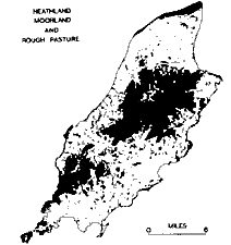
FIG. 6.
In addition to these two large tracts of highland pasture and moorland there are small patches of rough grazing to be found on many parts of the east and west coast. These are scattered and occur where the Manx Slate series forms a cliffed coastline; the slopes adjacent to the coast are frequently too steep and have too thin a soil cover to be put under cultivation and such areas are left as grass and heather for rough pasture.
Occasional isolated heath. patches are to be found within the solidly arable lowlands. These are usually rough areas left on local elevations or slopes that are too steep or stony to be worth ploughing and are frequently overgrown with gorse and bracken both of which spread very rapidly and have been one of the big problems for the Manx farmer.
Along the steep-sided glens where the streams have eroded into the east and west coastal plateaus there are many patches of rough ground and where the glen floors are choked with drift and the drainage has been impeded mossy bogs and areas of rushes have developed. On the Land Utlisation map the east and west coast glens are conspicuous by having their courses marked by a ribbon of yellow. The western half of the Ballaugh Curragh is still a rushy wet waste as a result of very poor drainage.
The drainage of the Central Valley is through glacial drift and along the valleys of the Dhoo and Neb marshes and heath alternate with damp meadow-land.
One stretch of land included in this category remains to be noticed, namely the Ayre. This is the raised shingle beach in the extreme north of the island extending from the Point of Ayre south-westwards in a narrowing strip almost to Jurby Head. This barren strip carries no settlement and provides only very poor pasture land for the farms to the south.
Although the abundance of bog oak in the peat bogs shows that parts of the island were once wooded, trees have been rare in historic times. The acreage naturally under wood in the island to-day is insignificant and the island generally is bare of timber. The total area of land in this category, however, has been increased by the afforestation of Crown Common Lands, the plantations, mainly of larch, at Archallagan, South Barrule and Greeba having been planted by and belonging to the Crown. The Isle of Man Forestry Board corresponds to the Forestry Commission in Great Britain and has practically the same powers with regard to forestry in the island. It was established under the Forestry Act of 1931 and is responsible to the Governor and Tynwald Court to whom a report is furnished annually. Wherever it was considered that trees would add to the beauty of the district the Forestry Board have carried out afforestation and plantations of spruce (Sitka and Norwegian), larch (European and Japanese), pine (Scots and Austrian), and fir have been made on Slieau Whallian, in Sulby Glen, Glen Helen, Glen Rushen, Laxey and Injebreck. Apart from the plantations there is no large extent of woodland but the best wooded districts are around Douglas, in parts of the Central Valley and at the foot and on the lower slopes of the northern edge of the Manx massif. Most Manx farms moreover are sheltered by a small clump of trees. The general result of the scarcity of forest and woodland is that the most characteristic feature of the countryside is its openness. The whole island, in the absence of woodland, is exposed to the fresh south-westerly winds and most parts feel the full sweep of the gales. Wind presents a much more serious problem to the Manx farmer than does any other climatic element for all too frequently high winds in August flatten the ripening corn crops.
An interesting consequence of the general shortage of timber on the island is that certain kinds of scrap iron have been found a convenient and economical substitute for wood for such farm requirements as fencing and hedging. Old iron bedsteads are imported from the mainland specially for this purpose, the frames being broken. up for supports for wire or netting while the ends are used to fill up gaps in the hedges. This use of iron is not found to any extent in the limestone basin of Malew for there the typical fences are made from the local stone and are an inheritance from the prosperous large estates which were built up in this fertile southern arable district.
In the Isle of Man this category embraces land occupied by industrial, commercial and civic buildings, railway sidings, stone quarries, clay and gravel pits, brick works, waste heaps and dwelling houses so closely spaced that they have no land attached which is capable of agricultural production. Altogether the area in the island is extremely small. Dense urban settlement is strikingly absent from the island and the two largest urban settlements, Douglas and Ramsey, have only a small region in their centres and near the harbours which is so closely built up as to have buildings without gardens or recreational spaces. In the case of the smaller settlements such as Peel, Castletown, Port St. Mary and Port Erin only the central part of the settlement immediately adjacent to the main road could be included within this category.
The island is rich in lead, zinc, copper and silver, but although there was mining on a small scale in the eighteenth century, the period of real activity was confined to the middle of the nineteenth century and mining has now practically ceased. The richest mineral veins are found in the neighbourhood of the Dhoon, Foxdale and Santon granite masses. The metalliferous dykes radiating from these have been exploited mainly at Laxey and Foxdale but in addition to these workings there is scarcely any glen in the island in which there are not to be found " levels " driven into the hillside on the line of surface indication of ore. In the Laxey and Foxdale valleys rock waste heaps from these old quarries account for the land shown as agriculturally unproductive, while the larger area of barren land on South Barrule is accounted for by the South Barrule quarries which have worked the granite outcrop there. To-day the Foxdale mining is limited to quarrying a vein of snowy quartz for ornamental purposes and for road metal. Within the limestone basin the most important quarries are at Ballahott and these have supplied limestone not only for building purposes but also for burning in the lime kilns at Ballahott, a formerly important supplier of lime to all parts of the island. Near Peel sand, gravel and brick clay quarries have been worked. The brick earth originally used by the Glen Faba Brickworks was found in the near-by hillside but to supplement this supply a new clay pit has recently been opened in the blue clayey drift of the coastal plateau at Knocksharry.
There are few slate quarries because Manx Slates have no true cleavage and so do not produce roofing slates.
During the war of 1914-18 a tract of land at Knockaloe was used as an internment camp. After the war the Manx Board of Agriculture took over Knockaloe as an experimental farm for the Isle of Man and the site of the famous camp was ploughed up, only a few of the better buildings being left to be used as labourers' cottages. There are naturally inconsistencies in this area between the various published maps and it is to be noted that the actual land use is arable.' This section has been contributed by Dr. E. Davies.
The areas shown on the Land Utilisation map by a purple colour includes all land occupied by houses having gardens sufficiently large to be productive of fruit, vegetables or flowers irrespective of whether or not they were so used at the time of the survey. Normally the Land Utilisation Survey differentiates on their published maps between houses with gardens on the one hand and orchards and nurseries on the other but in the Isle of Man the acreage of land under allotments, nurseries and orchards is so very small (about 110 acres) as to be almost negligible and it was impossible to show orchards separately because almost all the hard and soft fruits are grown in the small gardens attached to most farms, houses and cottages. The absence of large orchards is a reflection of the cold and late springs which are unfavourable to the blossoming of the fruit trees and the summer and autumn temperatures which are not sufficiently high to allow the ripening of stone fruit. Where there are occasional fields under soft fruit in the south-east of the island these have been shown as arable since the ground is normally devoted to ordinary field crops. The average total acreage of small fruit is only about 20 and although the soils of the north and south-east of the island are very suitable for this crop it is not more developed because the fruit would be ready only in the late summer and autumn after the market provided by the visiting population had largely disappeared.
The distribution of settlements, based as it is on the immediate exploitation of the soil, bears a close relationship to the form of the land. The broad pattern of settlement therefore falls conveniently into two main forms, that of the upland and the coastal plateaus which flank it on each side, and that of the more low-lying tracts of the northern lowland with its morainic hills, the south-eastern lowland centring on the Carboniferous Limestone basin of Malew, and the area underlain by red standstone behind Peel. The yield of the soil has long been supplemented by the harvest of the sea, especially along the west coast, and although the importance of fishing in the economy of the island is now largely of only historical interest, it has been important in helping to determine the nature of settlement particularly in the south-west of the island. During the nineteenth century mining became important in Foxdale and in the Laxey valley and linked as it was with the cultivation of small-holdings it has left its mark, although as an economic system it was but a passing phase.
On the upland and around its fringes the basis of settlement is topographical, in that the farms and cottages are more numerous in the lower reaches of the larger and broader glens and on the intervening portions of the coastal plateaus and become more widely separated as the land rises towards the central upland and good agricultural land becomes scarce. There are few habitations above 500 feet, whilst the 65o-foot contour may be taken as marking, for practical purposes, the upward limit of enclosed fields, which even at this level have occasionally passed the limit of economic profit. In the east and south-east, where the glens are more numerous and broader and the lower plateau is wider, there have been better opportunities for farming, especially in the south-east, where there is a smoother topography, with gentle valleys rather than steep glens and so the basis of life is, and always has been, entirely agricultural. On the western side of the island, however, the steeper glens and the narrower coastal plateau, facing the open ocean, have restricted the amount of agricultural land so that here agriculture and fishing have long gone hand in hand, especially in the south-west, where, south of the central valley, the lower plateau diminishes to a narrow coastal ledge and crofting was the prevalent type of economy. The decline in the fishing industry set in after about 1850 and led to a decay of crofting economy. Many of the crofts and farms of the fisher-farmers were situated on the edge of the waste and with the decay of the supplementary occupation of fishing these marginal holdings ceased to be economic propositions and rural depopulation occurred, leaving the edge-of-the-waste cottages derelict while the land was absorbed into larger holdings. Such crofts were most numerous in the west and south-west of the island, in the parishes of German, Patrick and Rushen, and especially in the last where settlements grouped around and near small bays and coves are a characteristic feature. As the Manx valley floors are generally filled with detritus and are often mossy bogs, concentrated settlement has been usually on gravel terraces overlying the drift, since the valley sides are steep.
The more low-lying areas of the island show a less simple pattern of settlement. North of the Curraghs, where the land rises in a series of broad shallow platforms of sand and gravel to the morainic hills, water is scarce near the surface and this has determined, to a considerable extent, the distribution of settlements. The trough of the Lhen serves to mark off the platforms in the parish of Jurby as a district unit. On the platforms themselves farms and houses are few, especially in the west where, in a broad belt around the hamlet of Jurby, the gravels are coarse and thick. Towards the south and east the gravels become less coarse and settlement increases, but the farms are, in the main, ranked along the southern edge of the platforms where water is given out against the underlying clay, and also along the eastern border where the gravel is thin.
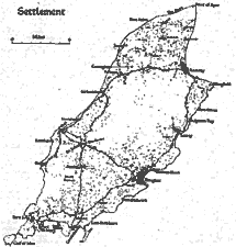
Fic. 7.-Settlements and main roads in the Isle of Man.
These are the areas normally shown in red (closely built over) and purple (houses with gardens) on the one-inch
maps of the Land Utilisation Survey.
The platforms which extend from the Lhen to the east coast descend from an altitude of about 100 feet near the Bride Hills to about 30 feet along the borders of the Curraghs, but the terrace-like edges which are distinct near the east coast soon become lost, and in the west the gravels slope gently to an ill-defined marshy margin. Attention has been drawn to the arrangement of the boulder drift in two arcuate belts extending from near St. Jude's to Blue Point and from Ballalheaney to Ballavair in the parish of Bride. Settlement tends to be denser on these areas of boulder drift than on the dry sand-and-gravel platforms, as may be seen particularly in the belt between these two expanses of drift. The relative density of settlements is marked in the area between Ballalheaney and Ballavair and here the subsoil is composed chiefly of stoneless red clay with glacial sand, gravel and boulder loam on the surface. Southwards towards the wet Curraghs, settlement on the sand-and-gravel platforms is denser than in the north.
The hilly portion of the northern moraine ends near Smeale and westwards it decreases to elevations of ioo feet and less. The hills contain many deep dry valleys some of which traverse their entire breadth. The valleys have a long southward slope and a short, steeper, northward slope but settlements are more frequent along the northward slopes while on the southern side they are arranged along the line where the hill-slopes pass into the gravel platforms except where the western arc of boulder-drift carries a belt of settlement across the platforms and the hills.
The northward limit of settlement is marked by the ancient cliff which forms the northern border of the drift deposits although along the inner borders of the Ayre the blown sand has been made cultivable by mixing it with clay from the adjacent drift cliff.
The Curraghs, lying between the sand-and-gravel platforms and the truncated border of the central upland, are an area of recent settlement. Considerable farms are few and where they do occur they are situated on the gravel spurs and islands which rise out of the wet tracts. The Rule, Curragh, Closechirrym, East and West Kella, Close-an-Allan and Ballamona are examples of such settlements. Apart from these larger farms there are a number of small settlements of the squatter type but these too follow the lines of the gravels and the roads. Away from these drier patches settlements are absent and the wet Curraghs are next to the dry Ayre, and the barren heights, the least densely populated area of the island.
The lowland of Malew centres on the basin of Carboniferous rocks, but topographically it extends beyond these geological limits because the streams that radiate south-eastwards from the slopes of South Barrule have gentle profiles and the land slopes very gradually so that, at distances of even four miles from the coast, the elevation is generally below 500 feet, whereas elsewhere around the Manx massif such an altitude is attained at distances of about a mile, or less, inland from the shore. The Carboniferous Limestone series forms a low-lying, gently undulating area which is covered by a thick layer of drift or of alluvium. The south-eastern part, which would be enclosed approximately by a line drawn from Poyll Vaish to Ballasalla and thence to Loch Skillicore, is covered with glacial sands and gravels occurring as platforms. This forms a dry tract with few wells and a sparse distribution of settlements. North-westwards, the gravel platforms are replaced by boulder-drift and on this land, as on the northern lowland, wells and settlements, which go hand in hand, become more frequent although it lies within the boundaries of the area underlain by the Carboniferous Limestone series, but settlements remain more sparsely distributed than is the case still farther north-westwards on the land underlain by the Manx Slates series, where, on the south-eastern slopes of the upland, wells and springs are abundant and settlement is closer.
The narrow strip of red sandstone which borders the coast behind Peel forms the nucleus of a third relatively low-lying area which is distinct from the plateau-fringes of the Manx massif in its settlement. The sandstone, which is overlain by glacial sands and gravels arranged in mounds, forms a smooth, rolling landscape sloping gently seawards where it terminates abruptly in steep cliffs 50 to 60 feet high. The nature and density of settlement is similar to that on the land underlain by the Carboniferous Limestone series in the Plain of Malew.
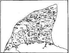
Fig. 8.-Geology and Settlement in the Northern Lowland.
B.S.-Blown Sand; B.D.-Boulder Drift; F.G.-Late Glacial Flood Gravels ;
S.Gm.-Glacial Sands and Gravels occuring as mounds; S.Gp.-Glacial Sands and Gravels occuring as platforms ; A.-Aluvium ;
P.-Peat.
The size of individual holdings in the island is not great. Farms with considerable areas of good-quality land are common only in the low-lying areas of the northern lowland and the lowland of Malew. Away from the relatively level areas the farms are aligned mainly in strips along the slopes, extending from the lower to the higher land, so as to provide a fairly equitable division of the land with areas of meadow, arable land and upland pasture. In the valleys and glens the individual holdings are arranged athwart, rather than along, the slopes and the stream tends to act as a base-line on to which the farm-lands abut, and from which they extend upslope. On the plateau areas away from the river valleys, or where the streams occupy very steep and narrow glens and fissures, which offer little or no farming land, the sea-coast forms the base-line along which the holdings align themselves and they extend from shore to hill in long adjacent tracts. Possession of a strip of seashore was valued in former times as a source of seaweed for manure and the right to cart seaweed was, and is, held by all landowners. A similar arrangement obtains along the northern flanks of the moraine in the north, and along the margins of the Curraghs which provided peat and wet grazing for the farms of the dry sand-and-gravel platforms. The prevalent form of settlement in the Isle of Man is the Einzelhof of Meitzen.[1 Meitzen, A., Siedelung and Agrarwesen etc., Berlin, 1895].
The farms are isolated units with the homestead set among its own grouped fields. Each farm is complete in itself and has no necessary relation to any other farm although the farmers practise mutual help in the major farming operations of harvesting. This independence and unity of each holding is shown in the field-names which are significant only within the boundaries of the particular farm to which they belong, for they are duplicated often in several neighbouring farms. There is no trace in the island of the agricultural village based on rotation farming of common fields, working its lands in common and forming an economic unit. Stock-rearing and the growing of spring corn lent itself more easily to semi-independent family-farming, and the three-field system accordingly did not establish itself. The rural agglomerations of the island are therefore hamlets rather than villages and they reflect merely the universal human tendency to collect around chapel, church and inn, ford and bridge, road-junction and, later, railway station. Exceptions to this general statement are Ballasalla and Foxdale. The former contains the ruins of the old abbey of Rushen, which once held large estates in Malew, and Ballasalla with its livestock mart is to a considerable extent the agricultural centre for the south of the island. St. Johns, a rail and road junction, also has an important livestock mart but the settlement consists of only a few houses grouped around the church and Tynwald Hill, the symbol of Manx independence. Foxdale is in form a fairly typically straggling mining settlement which grew to its present form only during a period of mining prosperity in the latter half of the nineteenth century.
|
1-5 |
5-20 |
20-50 |
50-100 |
100-150 |
150-300 |
300-500 |
500-700 |
700-1000 |
|
|---|---|---|---|---|---|---|---|---|---|
|
Patrick . |
7 |
11 |
20 |
17 |
10 |
6 |
1 |
0 |
0 |
|
German . |
13 |
19 |
23 |
37 |
10 |
7 |
0 |
0 |
0 |
|
Marown |
5 |
15 |
9 |
17 |
13 |
3 |
0 |
0 |
1 |
|
Michael |
4 |
10 |
15 |
15 |
8 |
1 |
2 |
0 |
0 |
|
Ballaugh |
2 |
14 |
10 |
19 |
6 |
3 |
0 |
0 |
0 |
|
Jurby |
4 |
6 |
13 |
17 |
5 |
6 |
0 |
0 |
0 |
|
Andreas . |
8 |
29 |
27 |
25 |
10 |
10 |
2 |
0 |
0 |
|
Bride |
4 |
12 |
7 |
15 |
11 |
5 |
0 |
0 |
0 |
|
Lezayre . |
18 |
26 |
21 |
20 |
6 |
6 |
0 |
0 |
0 |
|
Maughold |
4 |
12 |
15 |
20 |
7 |
2 |
1 |
0 |
0 |
|
Lonan |
2 |
7 |
15 |
21 |
10 |
1 |
0 |
0 |
0 |
|
Onchan . |
2 |
4 |
6 |
14 |
10 |
6 |
1 |
0 |
0 |
|
Braddan |
9 |
8 |
10 |
24 |
7 |
14 |
0 |
l 0 |
0 |
|
Santon . |
2 |
6 |
7 |
12 |
2 |
9 |
0 |
0 |
0 |
|
Malew . |
7 |
16 |
24 |
35 |
20 |
8 |
0 |
1 |
0 |
|
Arbory . |
6 |
10 |
14 |
10 |
10 |
2 |
0 |
0 |
0 |
|
Rushen . |
5 |
11 |
15 |
13 |
8 |
4 |
0 |
0 |
0 |
|
Douglas . |
15 |
7 |
2 |
0 |
0 |
0 |
0 |
0 |
0 |
|
Total . . . |
117 |
223 |
253 |
331 |
153 |
93 |
7 |
1 |
1 |
Apart from these rural agglomerations are the larger centres around the coast, and the diverse lines along which they have developed are of considerable interest. Douglas, with its better natural facilities, has become the chief port and holiday resort. Ramsey acts as a minor port and a more conservative holiday resort but it has maintained its function as the agricultural centre of the north of the island. Peel rose as the centre of the fishing industry of the west coast, especially the herring fisheries, and it is still the chief fishing port of the island ; its part in the tourist traffic is relatively small. Castletown, the island-capital before the rise of Douglas, has remained mainly a residential centre which tends to keep itself apart for it has never concerned itself with the tourist traffic. Laxey, Port Erin and Port St. Mary were merely fishing centres until the nineteenth century when the mining of copper, zinc and silver-lead ores in the Laxey valley drew population up-valley and when the development of catering for summer visitors, coinciding with the decline of fishing and crofting, brought new lines of development for Port Erin and Port St. Mary which have increased very rapidly during recent years.
|
|
||
| |
||
|
|
||
| Any comments, errors or omissions gratefully received The
Editor HTML Transcription © F.Coakley , 2007 |
||