Glen Helen (used as frontispiece)
[From Abel Heywood Illustrated Guide 1885]
ALDWIN and Injebreck are exceedingly beautiful and well worth a visit. The best road for a vehicle or a pedestrian is past the cemetery, near Kirk Braddan Church, to the Strang village, where roads lead to East and West Baldwin Valleys. The visitor, after passing through West Baldwin Valley towards the north, will arrive at Inje breck, which is very romantic. The river Glass has its source in Injebreck. The road over the mountain leads to Kirk Michael and the north of the island. The mountains of Carraghan and Bein-y-Phot may be ascended from the road; the former being 1,520 and the latter 1,772 feet above the level of the sea. The pass between Greeba and Carraghan Mountains is about a mile from Injebreck, from whence a beautiful view is obtained of the sea surrounding the island and portions of Scotland. The return to Douglas may be varied by passing St. Luke's, a Chapel-of-ease to Kirk Braddan, which is built on the site of an ancient treen oratory called Keeihill Abbane, close to which are the remains of a Tynwald Mount where the Commons of the island met in 1429.
The antiquarian, in visiting this spot, will find much to interest him. The direct way to the glen is first to proceed to the Union Mills, and then take the road past the little Wesleyan Chapel, near the Union Inn. The road leads by Mount Murray, and past some Druidical stone circles at the glen. Beautiful views are obtained on the road. The stone circle is in a field on the right of the road. These circles, according to Dr. Cumming, are the burying places of the British or Scandinavians who first settled on the island. The road leads to Slieu Chaiarn Mountain, which means the "Lord's Hill." A splendid view is obtained by going round it. A little way on the road is the "Garth," which means the Danish Farm; a little way further is the field called Magher-y-Chiarn, or the "Field of the Lord," where there are five upright stones standing on a native blue flag-stone. These stones are called "St. Patrick's Chair," and, if tradition is to be believed, the saint used to "sit there and bless the people." The road will take the pedestrian past Marown Church, whence the main road leads to Douglas.
A visit to Glenmay Waterfall, with the various objects of interest on the road, can scarcely be omitted in a visit to the island. The distance is too far except for an experienced pedestrian. Coaches run from the Market Place. If the railway is used as far as St. John's (return fare, 1st class 2s., 3rd 1s. 2d.), the rest of the journey is easy of accomplishment. The main road to Glenmay is the Peel Road as far as St. John's. The visitor passes through Union Mills, Marown, and on the right, after passing the church, is "Aitken's Castle," or, as it is commonly called, " Aitken's Folly." The Rev. Robert Aitken, by whom it was built, was at that time a Methodist minister, but afterwards became a clergyman in the Church of England, and, in his day, was a very celebrated revivalist. The " Christian Society," which he founded, has now no existence. The property was sold in 1875, and is now in the possession of various owners.
Passing the Folly the village of Crosby is reached, and the Half-way House. The mountain of Greeba, on the right of the road, is 1,591 feet above the sea, from whence a beautiful view is obtained. Greeba Tower and Greeba Castle are interesting objects in the view. The tower spoils the view from the castle, as it was intended by its selfish builder. The fare to Crosby is, 1st class, 1s. 1d.; 3rd class, 9d. return.
is close to a small inn, a little way out of Crosby, in a field adjoining the road. It is a small building, without roof, and half concealed. The story connected with the church is curious, and, of course, incredible. It is said the building was commenced by a person who made a vow when in a hurricane at sea, but the building was never finished. The cause of this, according to tradition-which, of course, is true, - was owing to a mischiveous Buggane, or evil spirit, who amused himself with tossing the roof to the ground as often as it was about to be completed. The real supposition is that the completion of the building was delayed owing to the confiscation of the barony by the second Sir John Stanley.
Near this famous roofless church is the field called Ye Cheance Rhunt, or the Round Meadow, to which is attached a legend of the Phynnodderee, or Hairy Satyr, which is credited with doing, occasionally, useful things. Amongst others it was accustomed to mow the meadow. It ceased its work when the farmer grumbled that the grass was not cut close enough. On the farmer attempting to mow the grass the satyr went after him, stubbing up the roots so fast that it was with great difficulty the farmer saved his legs.
Greeba Castle is open as a restaurant and public gardens. The land near the "round meadow" is called the Curragh-glass, or " Gray-bog," which tradition states at one time to have been "a wide-spreading lake that glassed the deep shadows of the surrounding mountains." The lake has been gradually filled up by the growth of peat beds, in which bog-oak and the remains of antlers and other portions of the great Irish elk have been found.
After leaving the scene of these legends the visitor will shortly arrive at St. John's Chapel and the Tynwald Hill. The chapel is in the gift of the Crown, and is, in its position, an object of considerable beauty. It is built of the light-coloured granite found on the mountains of South Barrule, in the early decorated style. In the south-west corner, close by the church, is a Runic monument, beautifully carved, with an inscription signifying that " Inosruier engraved these Runes."
Exactly 200 yards from the church is the Tynwald Hill, the most noteworthy spot on the island. At one time it was supposed to be a Danish sepulchral barrow: but it is more probable that it was erected for the purpose which it now serves. Tradition also asserts that it was composed of soil brought from every parish of the island. Its name is derived from the Danish Ting, a court of justice; and Wald, a fence., The hill is surrounded by three rows of seats, cut out of the side, for the accommodation of the official persons, the clergy, and the Keys. The mound is about 21 feet in circumference. On this was placed the chair of state for the king, or, in his absence, the governor. The hill is 12 feet high and the circumference of the base 240 feet. On the 24th June, 1417, Sir John Stanley, King and Lord of Man, held the first Tynwald Court of which any record has been preserved. The following extract from the statutes shows the nature of the directions for conducting the Tynwald Court :-
" Our Doughtfull and Gracious Lord this is the Constitution of old Time the which we have given in our Days how yee should be governed on yourTynwald Day. First, you shall come thither in your Royall Array as a King ought to do by the Prerogatives and Royalties of the Land of Mann. And when upon the Hill of Tynwald sitt in a Chaire covered with Royall Cloath and Cushions, and your Visage into the East, and your Sword before you holden with the point upward ; your Barrons in the third degree sitting beside you, and your beneficed Men and your Deemsters before you sitting; and your Clearke, your Knights, Esquires, and Yoemen about you in the third degree, and the worthiest men in your land to be called in before your Deemsters if you will ask anything of them and to hear the government of your Land and Will, and the Commons to stand about the Circle of the Hill, with three Clearkes in their Surplisses. And your Deemsters shall make call in the Coroner of Glenfaba, and he shall call in all the Coroners of Mann ard their Yards in their Hands with their Weapons upon them either Sword or Axe. And the Moares that is to Witt of every Sheading. Then the Chief Coroner that is the Coroner of Glenfaba shall make Affence upon paine oŁ Life and Lyme that noe man make any Disturbance or Stirr in the time Tynwald or any murmur or rising in the King's presence upon paine of Hanging and Drawing. And then shall let your Barrons and all other know you to be their King and Lord and what time you were here you received the Land as Heir Apparent in your Father's Days."
After prayers in the church on Tynwald Day, a procession is formed in the following order :-Constables, coroners, captains of parishes, the High Bailifis, the clergy, the members of the House of Keys, the Vicar-General, the Archdeacon, the Water-Bailiff, Clerk of the Rolls, the two Deemsters, the Attorney-General, the Lord Bishop, Sword of State, His Excellency the Governor, and constables.
On arriving at the summit of the hill, the senior coroner of the island, by command of the Governor, " fences the court" in these words:- I do fence the King of Man and his officers, that no manner of men do brawl or quarrel, nor molest the audience, lying, leaning, or sitting, and to show their accord, and answer when they are called, by license of the King of Man and his officers. I do draw witness to the whole audience that the court is fenced."
The Tynwald Day is on the 5th of July, on which day all laws that have received the royal assent are read or promul-gated; and without such promulgation they cannot become law. Formerly all the laws were read in extenso; now, however, the side headings only are read. On this occasion the coroners for the past year go out of office, the insignia of which are small canes with a piece of ribbon attached. The new coroners, kneeling on the ground, are sworn in by the chief deemster or judge.
After the ceremony the procession is re-formed, and when in the church the Governor, Council, and Keys sign the acts which have been promulgated, and transact any other business necessary to be brought before the Tynwald Court a court composed of the Keys and the Council.
Tynwald Court day is also a fair day, which is resorted to by thousands of the inhabitants, as well as strangers. As the neighbourhood of the hill has been the scene of many sanguinary conflicts, numerous remains have been found in the fields. In 1847, when the road was widened, a tomb was discovered, consisting of four upright stones, and one above, which is called the "Giant's Grave;" about fifty yards distant a battle-axe, stirrup, and beads of various colours were found. Professor Forbes placed these interesting relics in the Jermyn Street Geological Museum, London.
Three of these stone tombs, or cists, were found about a mile further westward, at a place called Cronk-y-Keeihll-Lhane, on the estate of Balla-Keeihll-Moirrey, near Ballalough. One was empty, a second contained a scull, which crumbled to dust on exposure to the air; the third contained two entire skeletons and some bones.
The visitor intending to visit Glenmay must cross the railway at St. John's, and turn up the road on the right hand, which runs along the northern foot of Slieu Whallin, by the side of the stream from Foxdale. Just below this point the stream is joined by the one from Glen Helen, and then the two form the Neb or Peel River.
The next object of interest is the Parish Church of St. Patrick, 2˝ miles from St. John's. The church is a plain building, notable as having been consecrated by Bishop Wilson in 1715. In this district supernatural tales abound-how, that the Phynnodderee would gather belated sheep from the mountains and bring them home; and thrash sheaves of corn of poor and short-handed farmers. Many other tales are told-all equally true.
The Glenmay village boasts of two inns-the Oddfellows' Arms and the Waterfall Hotel. The latter is specially a summer house devoted to the service of visitors, and to which is attached ample stabling accommodation. Before making the turn to the hotel, a very excellent view is obtained of the glen. The Waterfall is reached from the field nearly opposite the hotel, where tickets and needed information may be obtained. The fall is not large, and in this respect the visitor may be disappointed; but he cannot fail to be interested in the singularly picturesque appearance of the glen. The water of the fall is discoloured by the lead washing at the mines higher up the stream at the foot of South Barrule.
About a quarter of a mile from the fall the beach is reached, where a wooden footbridge spans the stream. The beach is admirably adapted for bathing. Majestic rocks seem to protect each side of the glen. On the north side there are some interesting caves, which can be visited when the tide is out, or at other times by boats.
From Glenmay, if the visitor is so disposed, he may make the ascent of South Barrule ; also visit Niarbyl Point, where a magnificent view of the island may be obtained. By crossing the stream at Glenmay village the road leads along the Dalby Hill, from whence a beautiful view of the Scotch and Irish coasts is obtained. On arriving at Niarbyl Point, a few hundred yards from Dalby village, one of the finest views on the island meets the tourist.
A short distance from the village of Dalby a road on the right leads down the glen-Dalby Lhag, and along to Cronk-na-Irey-Lhaa, at the foot of which are the ruins of a treen chapel - reputedly the burial place of the Kings of Man. The whole district is filled with objects of interest. The visitor must return to St. John's if he wishes to visit
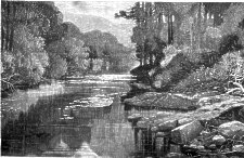
Glen Helen (used as frontispiece)
If the visitor makes this interesting locality the object of his trip from Douglas, and he selects the railway as his method of locomotion, he will get out of the train at Ballacraine, where an omnibus will convey him to the gates of this most interesting glen-the distance being two miles. This is the most popular resort for visitors on the island. Its name is derived from the daughter of the purchaser of the glen, about 30 years ago-Mr. Marsden, of Liscard Castle, near Liverpool-who planted it with upwards of one million trees. He also built the Swiss Cottage at the entrance to the glen, at a cost of Ł1,400. The grounds are plentifully supplied with games and amusements.
The waterfall is about a mile from the cottage, the walk.: to which presents some charming scenery. About half a mile further beyond the fall is the Rhenas farmhouse, a road from which leads by the foot of Scartfell to Cronk-y-Voddee, and the main road from Glen Helen to Kirk Michael. The other road, from the farmhouse, by the side of the stream, for about half a mile, leads to Little London. The mountain road leads to Injebreck, and on by the valley of the Glass to Baldwin and Douglas. If the visitor does not care to subject himself to this foot journey-for it can be scarcely taken in any other way,-he will retrace his steps to the gates, where he will have a choice of methods of returning to Douglas or proceeding to
The railway which carries the visitor from Douglas to Peel, a distance of 12 miles (return fare 1st class, 2s. 6d.; 3rd 1s., 8d.), through scenery not less charming than that of the southern line, is the work of a limited liability company, with a capital of Ł160,000 in 32,000 shares of Ł5 each. Peel was anciently called Holme, or Holme Pile, and is the most important fishing town on the island. There are about 200 boats and 2000 men and boys engaged in the fisheries. The town is noted for its excellent manufacture of fishing nets, which are an article for exportation as well as for home use.
Peel greatly reminds the tourist of the Scotch fishing towns of the Northern Highlands, and with its ruined Castle and Cathedral on the adjacent island, presents many fine subjects to the artist's pencil. There is a fine pebbly beach to the north of the town, and some fine sea worn caves of old red sandstone which will afford a few hours' pleasant occupation, and from which a fine sea view may be obtained of the old castle.
The Quay, erected in 1810, is a busy place during the fishing season. The jetty, to shield the harbour, was built in 1830. The church, St. Peter's, re-built in 1816, has 600 sittings. The Free Grammar School was founded in 1746 by Philip Moore, Esq., who endowed it with Ł500, with the directions that the interest should be paid to a master to teach the " Latin language, and such other learning as may prepare youth for the service of their country in Church and State." A Mathematical School was also founded in 1763 by the Rev. James Moore, of Dublin, who endowed it with the rent of three houses in that city, value Ł20. He also gave his books and instruments for its use. By a more recent arrange ment these two institutions have been united. A still older school in point of foundation is that of Philip Christian, founded in 1652, and known as " Christian's Endowed National School." The present schoolhouse was erected in 1842.
is not only the most important object in a visit to Peel, but to the island. In order to obtain a good general conception of the ruins of the Castle, a walk to the top of the hill overhanging the grounds will well repay the trouble. The islet upon which the Castle stands, contains 7 acres, and is surrounded by a wall 4ft. thick, flanked with towers, which was built by Henry, fourth Earl of Derby, in 1593: The walls enclose the ruins of the Cathedral of St. German, of the Church of Saint Patrick, of a round tower, and buildings used probably as the occasional residences of the Bishop and Governor of the island. The fortress was at one time considered the strongest in the kingdom. It was also the prison of the Earl of Warwick, in the reign of Richard II., and of the Duchess of Gloucester, in the reign of Henry VI. During what may be called the Stanley period it was used as an ecclesiastical and common prison.
The regulations to view the ruins are stated at the door above the flight of steps, attainable by boat, or by a cause-way connecting the main land with the islet: each person is charged 2d., and children under 12 years id. Visitors may view the ruins from 9 a.m. to 8 p.m., and on Sundays from .2 p.m. to 5 p.m. The old sergeant who accompanies the visitors, receiving a small gratuity for his services, communicates considerable information as he points out the various objects of interest. The guardroom is near the old portcullis door, which is said to be a thousand years old, and is interest-ing from a legend narrated by Waldron in his "Description of the Isle of Man," 1703:-
"It is said that an apparition, called, in the Manx language, the 'Moddey Doo,' in the shape of a large black spaniel, with curled shaggy hair, was used to haunt Peel Castle ; and has been frequently seen in every room, but particularly in the guardchamber. where, as soon as candles were lighted, it came and lay down before the fire, in presence of all the soldiers, who, at length, by being so much accustomed to the sight of it, lost great part of the terror they were seized with at its first appearance. They still, however, retained a certain awe, as believing it was an evil spirit, which only waited permission to do them hurt ; and, for that reason, forbore swearing and all profane discourse while in its company. But though they endured the shock of such a guest when altogether in a body, none cared to be left alone with it. It being the custom, therefore, for one of the soldiers to lock the gates of the Castle at a certain hour, and carry the keys to the captain, to whose apartment the way led through the church, they agreed among them-selves that, whoever was to succeed the ensuing night, his fellow in this errand should accompany him that went first, and, by this means, no man would be exposed singly to the danger : for, I forgot to mention, that the ' Moddey Doo' was always seen to come out from that passage at the close of day, and return to it again as soon as the morning dawned, which made them look on this place as its peculiar residence. One night a fellow, being drunk, and by the strength of his liquor rendered more daring than ordinarily, laughed at the simplicity of his companions ; and, although it was not his turn to go with the keys, would needs take that office upon him to testify his courage. All the soldiers endeavoured to dissuade him ; but the more they said the more resolute lie seemed, and swore that he desired nothing more than that the 'Moddey Doo' would follow him as it had done the others, for he would try whether it were dog or devil.
"After having talked in a very reprobate manner for some time, he snatched up the keys, and went out of the guardroom. In some time after his departure, a great noise was heard, but nobody had the boldness to see what occassioned it, till the adventurer returning, they demanded the knowledge of him ; but as loud and noisy as he had been at leaving them, he was now become sober and silent enough, for he was never heard to speak more ; and though all the time he lived, which was three days, he was entreated by all who came near him to speak, or if he could not do that to make some signs by which they might understand what had happened to him, yet nothing intelligible could be got from him, only that, by the distortions of his limbs and features, it might be guessed that he died in agonies more than is common in a natural death. The 'Moddey Doo' was, however, never after seen in the Castle, nor would anyone attempt to go through that passage, for which reason it was closed up and another way made. This accident (?) happened about three score years since."
Sir Walter Scott, refers in his " Lay of the Last Minstrel " to this tradition :-
" For he was speechless, ghastly, wan, Like him of whom the story ran,
That spoke the spectre-hound in Man."
The next prominent object is the Cathedral of St. German, of which not much remains. There was a former cathedral evidently from the fact that Raymond, Bishop of Man, was interred in St. German's Cathedral in 1151, and John, second Bishop, in 1154. The present cathedral was built in 1245, by Bishop Simon, who was interred in the chancel in 1245. It is constructed in the form of a cross, 114 feet long by 68 feet broad. From the tower, on a clear day, Scotland and Ireland may be seen. It is interesting to learn that in 1686 the cathedral was in a delapidated state, and that in 1710, by an act of Tynwald, the lead on the roof was, at the request of Bishop Wilson, devoted to the erection of the Church of St. Patrick, near Peel. Up to the end of the last century the building was used for public worship. Under the chancel is the crypt, 34 feet by 16 feet. It is barrel-vaulted, with ribs springing from thirteen pilasters on each side. Tradition says that if a prisoner was confined in it, and neglected to count the ribs, he would never come out alive. It was used as a prison until 1780. Thomas, Earl of Warwick, was made a prisoner in 1397, having taken arms against Richard II. In 1446, Eleanor, wife of Humphrey, Duke of Gloucester, was found guilty of treason and sorcery. It was said she, with asststance, had made a waxen image of the king; and that as the image melted away the health of the king would decline. The Duchess having been compelled to walk several times through the city without a hood, having a lighted taper in her hand, was sent to Peel Castle to be kept a close prisoner for life. Shakespear in the second part of Henry VI., act ii., immortalises the incident
King Henry.-
" Stand forth, Dame Eleanor Cobham, Gloucester's wife ; In sight of God and us your guilt is great.
Receive the sentence of the law for sins
Such as by God's book are adjudged to death. You, madam, for that you are nobly born, Despoiled of your honour in your life,
Shall, after three days' open penance done, Live in your country here in banishment, With Sir John Stanley in the Isle of
Man."
Save only for one hour each day the Duchess spent fourteen years in this wretched hole. She was carefully watched, not only to prevent her escaping, but to prevent her laying hands on her own life. The garrulous old Waldron says that every night, at the hour of twelve, a person is heard to go up the stone steps of one of the houses, which, of course, is supposed to be the spirit of the Duchess.
The cathedral is also notable from the fact that Bishop Wilson was enthroned in it on the iith of April, 1698. Another Bishop-Hildesley--the successor of Wilson, was installed in it on the 25th March, 1755-
A little beyond the cathedral is an old well, from which the garrison was supplied with water. It is a curious fact that although the islet is surrounded with sea water, no taste of salt is perceptible. Near the cathedral, on the sea side, a yard of a few feet square is pointed out as the place where the unfortunate Duchess of Gloucester took her one hour's exercise daily. A portion of the wall is pointed out where the soldiers poured boiling oil upon the heads of those assailing the castle ; and a chamber in which Captain Edmund Christian was confined. He had been the Lieutenant-Governor of the island, but he had offended the Earl of Derby by speaking some words against Charles I.
The object of chief interest to many visitors is Fenella's Tower, specially made interesting by Sir Walter Scott, in his charming story of " Peveril of the Peak." The oldest buildings within the walls are St. Patrick's Church, which is supposed to be the oldest church in the United Kingdom, said to have been erected by St. Patrick in the year 444; and the Round Tower, a copy, if not the original, of the Irish round towers. It is supposed to have been used in times of danger to secure. valuable utensils, books, and papers ; and as a sanctuary for the owners. Outside of the encircling walls there is a place shown as the '° Giant's Grave," whom tradition states to have been very wickedly disposed. He had three legs, which he could use so well that he could jump with ease the gorge between Peel Castle and Peel Hill. For amusement he one day took up a large block of stone, weighing several tons, and threw it against one of the hills, when it broke into three pieces, which, it is
said, can still be seen from the Castle. The chronicler avers that " the very marks of the giant's fingers, which he crushed into it when he tossed it from his hand," can still be seen. St. Patrick, who was then on the island, reprimanded the giant, who, in return, attempted the life of the saint. For this sin he was cursed in the name of the Virgin. He then, so the legend states, rushed at one stride over Peel Hill, and has not been seen in the island since. The grave, therefore, must only have been prepared for the reception of the three- legged prodigy, The stones with which the giant amused himself are pointed out near the mansion house at Lherghyd-hoo, in the parish of Patrick.
The hill on the south side of Peel is sometimes called Corrin's Hill, owing to the erection on its top, named " Corrin's Folly," having been built by a Mr. Corrin, about fifty years ago. His wife and child were interred beneath the building, and at his death, a few years ago, his body was also deposited in the same spot, but the remains have since been removed to another resting place. The tower is 50 feet high. It has become, by gift, the possession of the Board of Trade, as a landmark, and is so laid down in the sailing charts.
Before visiting Castletown, the metropolis of the island, the visitor from Douglas, either by car or railway, should stay for a short time at Ballasalla in order to inspect the ruins of Rushen Abbey - very little of which remains. The Abbey, five minutes w a 1 k from the Rail-way Station miles from Douglas - fares, 2S. and Is. 3d. return), is situated on the banks of the Silverburn, a beautiful trout stream which empties itself at Castletown. There is an hotel in the grounds in which the ruins stand. The grounds are rented and used as a garden for growing fruit; about fourteen tons are bottled annually and sent to Liver-
pool, and from thence to all parts of the world. The refectory and dormitory of the old abbey are now used as store rooms.
The abbey was founded in 1098, and greatly enlarged by No or Ewan, Abbot of Furness, on lands granted, in 1134, by Olave Kleining, King of Man, who granted the abbey many privileges, and also apportioned to the abbot, who was a baron of the isle, one third of the tithes of the island to be devoted to the education of youth and the support of the poor. The abbey was occupied by an abbot and twelve monks of the Cistercian order, who neither wore shirts nor shoes, and only ate flesh meat when on a journey. The abbots were appointed from Furness Abbey, and held courts of their own. The first monks who inhabited the abbey were poor and worked hard; in process of time, owing to increase of wealth, they became proud and indulged in luxurious living. The abbey was completed in 1257, and in the reign of Henry VIII. it was dissolved, and its revenues vested in the crown. It is said to have been the last monastery in the United Kingdom which was dissolved. The monastery and priory of Rushen and Douglas, and the " Grey Friars of Brymaken," were afterwards granted to William, Earl of Derby, on payment of a rent of Ł 122 12S. 11d. to the Manor of East Greenwich. In the abbey garden is an ancient tombstone, or coffin lid, called the "Abbot-stone of Rushen." A short distance up the stream from Rushen Abbey is the Crossag, or Monk's Bridge, which is one of the most ancient relics of former times now remaining on the island, appear-ing in the earliest records of the island, and showing by its construction that it must have been built before the introduction of wheeled carriages into the country. Proceeding onwards to Castletown by the main road the visitor will note
Visiting this chief educational institution on the island, Hango Hill, or Mount Strange, will be passed. The ruins on the hill are supposed to have been one of the " block houses," erected at the commencement of the Common wealth era, by the Earl of Derby. It is also notable as the place of execution of Illiam Dhoan (William Christian), who was shot at Hango Hill on the 2nd of January, 1662, for an act of treason against the Countess of Derby.
The College, which is directly opposite Hango Hill, is of a mixed order of architecture - Early English and Eliza-bethan. The cost of its erection was Ł6,572. The building was named after King William IV., and was founded in 1830 by Lieutenant-Governor Smelt, for the education of youths intended for the ministry of the Manx Church, for whom it was opened in 1833. The trust, originally founded by Dr. Isaac Barrow, Bishop of Man has now a revenue of about Ł6oo per annum, which is expended upon the endowment of eighteen scholarships in the College, ranging in value from Ł10 to Ł25 ; also four exhibitions to the Universities, of Oxford, Cambridge, or Dublin, for students willing to take Holy Orders, and to serve for a time in the island. Subsequent gifts to the College enable the trustees to grant two open exhibitions, of the value of Ł40 each, to the Universities, and five additional scholarships, value Ł20 each, in the college. The College consists of a chapel (St. Thomas's), library, class-rooms, museum, and dormitories, with residences for the principal and bursar.
The little fishing village of Derbyhaven, ten minutes' walk from the College, is the finest natural harbour on the island, which has many interesting historical associations.
In the middle of the harbour there is a breakwater. To the north of Langness, connected with Derbyhaven, is St. Michael's Isle, upon which a little chapel and an old circular fort-of great strength, are now in ruins. The fort is supposed to have been erected by Queen Elizabeth, in 1603. During the herring season a light is kept burning in the turret from sunset to sunrise.
Is 10 miles from Douglas, and the railway fares are 2/3 and 1/6 return. This is the metro-polis of the island, and was at one time the residence of the Governor. Formerly the chief courts of law and sittings of the insular legisla-ture were held in the town ; these have been gradually removed to Douglas. The Silverburn River, which rises in South Barrule, runs through the town. The population at the last census was 2,318. The harbour of late years has been improved at a cost of Ł4,500. The pier, which is composed of limestone, is 200 yards in length. The monument in the Market Place was erected to the memory of Governor Smelt, who died in 1832, after occupying his office for 28 years. An antique sun-dial, a few yards distant, is very remarkable. It is a solid stone ball, with thirteen dial faces, each marked differently.
'The hotels in the town are the George, the Union, and the Commercial. Near to the George Hotel is the only Barracks on the island, where about fifty- men are lodged. The church, St. Mary's, is built upon the site of a church erected by Bishop Wilson in 1698. The present church dates from 1826. The Wesleyans, the Primitive Methodists, and Roman Catholics have chapels in the town. The small building near the gates of the Castle is the " House of Keys," where the insular legislature have assembled to make laws for the island since 17o6, prior to which the " Keys " met in the castle.
It is said-and there is no other authority but tradition,-that Castle Rushen was erected, as it now stands, in 960, by King Guthred, or Godred, the second of the Orrys, who is said to be buried within its walls. The building is erected of lime-stone blocks taken from the near shore, or from Scarlet Point, and present the appearance, after centuries, as if recently erected. In the centre of the building is the keep, the ground plan of which is an irregular rhombus. It is flanked with towers. At the northern portion of the building is a lofty portcullis, passing which is an open quadrangular court, with a well in the centre. The clock was presented to the Castle by Queen Elizabeth, in 1597.
The thickness of the walls varies from 7 to 12 feet. On the outside there is an embattled wall, 25 feet in height and 9 feet thick, with seven square towers. Outside of the walls there was a moat, now filled up,-on the exterior of which Cardinal Wolsey erected a glacis, in which there were three round towers, now in ruins.
The visitor, on entering, will see on the left the Rolls Office, where the public records are kept. A flight of steps leads to the ramparts, and the Court House and Council Chamber. In the cell, on the left-hand side of the inner keep, Bishop Wilson was confined. The Bishop's two vicar-generals were also confined at the same time in a cell at the foot of the flag tower stairs. The room which is now used to confine prisoners was the room occupied by the Countess of Derby, when she was detained as a prisoner after the surrender of the island to the forces of the Commonwealth. The Castle is used as the common prison of the island. A view from the southern tower is well worth the labour of attaining. The castle, after a fortnight's siege, was taken and demolished by Edward Bruce in 1313, and remained in a ruinous condition for nearly 300 years, when the Earl of Derby re-erected his two Castles of Rushen and Peel.
A mile and a half from Castletown is Malew Church -a very ancient and in-teresting building, said at one time to have owned a cup received from the fairies, which, some-how, has disap-peared. The relics in the church must have been in use prior to the Reformation. A little silver paten has engraved upon it the inscription " Ora pro nobis Sancte Lupe." There is also in the church a curious brass crucifix, and part of a brass crozier or pastoral staff. The font is of granite, very roughly shaped.
If the visitor is disposed to make a little stay in Castletown there are many interesting places to which short excursions may be made. A very enjoyable boat trip may be taken to the Stack of Scarlet, and to the caves across the bay on Langness. The Stack is a vast basaltic pile, which may be reached, when the tide is out, on foot ; but at high-water it can only be reached by boat. Poolvash can be splendidly seen from the summit of the rock. Bishop Wilson obtained the marble from Poolvash which he presented to St. Paul's Cathedral, London, for the steps at the south and west entrances of that magnificent church.
A walk to Derbyhaven, Saltrick, and Santon Church, will well repay the exertion. On the way to Saltrick, the creek called Cass-na-Awin, or the °° foot of the waters," will be passed. Half a mile further, at Saltrick, there are some bold cliffs and caves well worth visiting.
If the trip is made by road from Castletown, the fine residence of the Gawnes, called Kentraugh, is passed; also, before arriving at Port St. Mary, in a field on the right hand, a gigantic slab about ten feet high, supposed to be one of the " banta sterior," which Odin enjoined upon the Northmen to erect to the memory of the brave. Port St. Mary, or Purt-le-Moirrey, as it is called in Manx, has a convenient and well protected harbour. At the extremity of the harbour is a small lighthouse, where a light, during the fishery season, can be seen thirty miles at sea. This is the rendezvous of the Manx fishing fleet during the herring season. It has two hotels. The schoolhouse is used for Episcopalian services, and there is also a Wesleyan and Primitive Methodist Chapel. The great object of attraction in visiting the little seaport is to view the Chasms.
which are upon the cliffs overlooking the sea, a mile and a half from Port St. Mary, near the Spanish Head, They are twelve in number, wide fissures in the solid rock, and so deep that the eye cannot fathom the dark abyss. Their origin is supposed to be a great landslip or an earthquake. The entrances to the caverns are, in some instances, more than a yard wide, and are dark and deep. Some have attempted to explore them, but report their efforts owing to the extent of the caverns, as fruitless. The most interesting way of visiting the Chasms from Port St. Mary is by boat, as the trip is really interesting; the boat will pass some fine vertical cliffs, landing in the Bay of Stacka, a little way beyond the Sugar Loaf Rock, half way from Port St. Mary, and the Calf Island. A climb from the beach takes the visitor direct to the Chasms. Views may be obtained from the heights near the Chasms of the Chickens Lighthouse, the Calf, the Sugar Loaf Rock, which is generally covered with sea birds. The Spanish Head is a magnificent mass of rock rising out of the sea, so called from the Spanish Armada, owing to a portion of the fleet of vessels fitted out to make a descent upon England having been lost upon the rock-bound coast. A boat from Port St. Mary will be needful to obtain a good view of this vast rock.
The little village of Craignaish, which is half a mile from. the Chasms, through the fields, has near it a circle of stones, 15 yards in diameter-two rows of upright stones, divided by oblong stones, which it is surmised had been the place where justice in the past was dispensed, one of the judges sitting in each of the spaces. There is also on the south side of the Chasms a small circle of stones about six yards in diameter.
The Calf Island is about four and a half miles in cir-cumference, a n d contains about 616 acres, and is separated from the main island by a channel called the
Sound," which, in its narrowest part is about 6oo yards wide, but at this part it is encumber-ed with several rocks, which render its navigation at all times very difficult. In its narrowest part the strait is divided into two channels by a small island called Kitterland. Right in the middle of its north western entrance is a shoal, visible at low water, known as the " Thousla Rock," upon which an iron beacon has been erected. The islet of Kitterland is said to have derived its name from Kitter, a great Norwegian baron, in the days of King Olave Goddardson, concerning whom many legendary stories are related.
The eastern entrance to the sound is about a mile and a half wide, and it is in beating across here that the full force of the current is experienced. There are two landing places on the islet-the Cow Harbour, on its north side, opposite the Thousla Rock, and the South Harbour, on the east coast, near the " Burrow," which is one of two huge rocks rising to a height of loo feet, the other being named the Eye," from a remarkable perforation made through it by the sea. On the summit of this perforated rock is a singular cruciform excavation called "Bushell's Grave," which is in reality an ancient post of observation, for which purpose it is admirably situated. Camden tells us that the islet of the Calf was once the station of a strong garrison. At present the greater part of it is rocky and barren, and the entire islet is overrun by innumerable rabbits. When it was dismantled of its fortifications, several of the cannon were brought to Port St. Mary, and placed as mooring posts on the Old Pier.
On the southern side of the Calf have been erected two lighthouses. Between the Cow Harbour and the lighthouses are the remains of a chapel, in which some Scandinavian relics were found. From the precipice near " Bushell's Ruins," on the west side of the islet, a fine view is obtained of the " Stack," separated from the Calf Islet by a distance of 50 feet.
About a mile south of the Calf is the Chickens Lighthouse, built of Dalbeatty granite, brought from Scotland. The lighthouse is 124 feet in height from foundation to top of masonry. Diameter at the foot of the tower is 42 feet, and at the top 16 feet. The revolving light stands 115 feet above the water.
The rocky projection at the foot of the Mull Hills, on the opposite side of the bay is " The Castles," and the width of the opening of the bay is about half a mile. The greatest depth of the bay, from Brada Head to the beach below the village is about a mile.
A breakwater, 950 feet in length, erected at the entrance to the harbour at a cost of Ł72,000, was utterly destroyed by the tremendous storms of the winter of 1883 ; the huge concrete blocks, weighing 17 or 18 tons each, being scattered about like blocks of wood. For the convenience of loading and unloading vessels, a concrete low-water landing pier is erected, 310 feet long, which runs parallel with the break-water.
There is capital fishing in the bay and neighbourhood, and small boats and fishing tackle can be obtained at moderate prices.
The Mourne Mountains, County Down, are very distinctly seen from Port Erin, if the weather is at all favourable for a view, and the scene from the summit of Brada Head is magnificent.
is a charming retreat, much visited by those who delight in a quiet, beautiful bay. The railway enables visitors from Douglas (151 miles-return fares 3s. 6d., 2s. 4d.) to explore its beauties, and spend a long day in its enjoyment. The two hotels, the Villa Marina Hotel and the Falcon's Nest, are specially provided with every desirable accommodation for visitors. A table d'hote, held at both hotels, enables the visitor to dine comfortably and cheaply. At the Villa Marina Hotel there is a chop and luncheon bar, a skating rink, and various amusements for visitors.
Boats may be obtained for a visit to the Chasms, or a sail in the beautiful bay.
The tower on the top of the headland, called Brada Head, was erected by public subscription, in honour of Mr. Milner, whose father was famous as the inventor of Milner's safes, and to whom Port Erin owes much of its prosperity. The large house opposite the Fál-con's Nest, known as the Rest, was built by Mr. Milner, as his Marine residence. He has left, amongst other , munificent bequests, sufficient money to build and endow a church for the thriving sea-port.
Near the row of cottages, built on the shore, is St. Catherine's Well, at one time held in reverence for the virtue and medici-nal properties of its water.
There are several objects of interest near Port Erin, furnishing opportunity for pleasant rambles. Fleshwick Bay, by the mountain road, through the village of Brada, is about two miles; the walk may be diversified on returning by crossing the " Fairy Hill," which is supposed at one time to have been a fortified place. A very beautiful and interest-ing walk may be obtained by keeping on the edge of the cliffs on the southern side of the bay down to the " Sound,"-the channel running between the Calf and the mainland.
This is a walk of two miles. About a mile and a half will take the visitor to the top of Brada Head, a good foot-path all the way, when a splendid view of the Calf and of Port Erin may be obtained.
The usual method adopted by the cars visiting Ramsey from Douglas is to go by the long road and return by the short road, viâ Laxey. This enables the visitor to see several interesting places on the same day. The drive, which cannot be surpassed for beauty on the island, commences on the Peel Road, and leads through Kirk Braddan, Union Mills and Crosby, passing St. Trinian's Chapel and Greba Tower on the right, and turning off at the Ballacraine Inn, a little before coming to St. John's. The road from that point to Ramsey is a continuous panorama of picturesque scenery. About a mile from Ballacraine, after skirting the river Neb we come to a beautiful miniature iron suspension bridge, and near it the Swiss Cottage at the entrance of Glen Helen, leading to the Rhenas Waterfall.
After leaving the entrance to these beautiful grounds the scene changes continually. The highest point of the road is at Cronk-y-Voddy, the " Hill of the Dog." As the visitor proceeds, glimpses of the sea, with a faint glimpse of the Mull of Galloway, 20 miles away, are obtained. The high mountain on the right is Sartfell, and its neighbouring mountain Slieu-ne-Fraughane. The visitor cannot fail, as he proceeds, to notice the increasing fertility of the soil, as he is now entering the most productive part of the island.
Kirk Michael, which he is approaching-having passed Cronk Urleigh, or the Hill of the Eagle (a name given to it by the Derby family)-is reputed the most salubrious part of the island. Immediately before entering the Episcopal village we obtain a grand view of the Irish Sea. To the left is " Erinville " the property of the Buchan family. Kirk Michael has two inns, court-house, church, chapel, school house, &c. There are several Scandinavian monumental stones at the entrance of the church. Bishop Wilson and Bishops Hildesley and Cregan were interred in the church-yard. Near Kirk Michael are Glen Moar with its romantic scenery; the beautiful Spootyvane Waterfall, 6o feet in height ; and one of the most charming glens on the island, Glen Willan, which extends from the sea two miles inland, and abounds in beautiful secluded walks. One mile from Kirk Michael the visitor arrives at
a large mansion half hid in the trees, one of which, a fine elm, is said to have been planted by Bishop Wilson. Portions of the palace are quite modern, but other parts are very ancient. Bishop Simon, in 123o, resided at Bishop's Court. The church, seen behind the palace, has taken the place of the old building, in which service is held twice on the Sun-day, when the Bishop is at home, which is very seldom. Bishop Wilson's chair is used when the Bishop sits in con vocation. The glebe consists of 6o6 square acres. The in-come of the Bishop, from the tithes and glebe, is Ł2,400 per annum.
The next village is Ballaugh, the birthplace of the eloquent Rev. Hugh Stowell, of Salford. The shore, which is one mile distant, past the quaint old church, is noticeable from the fact that the sea is gradually encroaching upon this part of the island.
About two miles from Ballaugh the village of Sulby is reached, at which point the scenery is astonishingly grand, and from which Sulby Glen, said to be " Mona's most savage retreat," may be visited. Half a mile further Sulby new village is passed, and Sulby river crossed. Then opens up even a more beautiful and fertile country than that already passed. Two miles from Ramsey the Church of
Lezayre is situated, at the foot of Sky Hill. It is a beautiful object in the landscape, overgrown with ivy. Soon after-wards we have North Barrule and the Albert Tower in sight, and get a view up Glen Aldyn on the right, and passing between Albion and Lezayre Terraces we enter, by way of Parliament Street, into
Ramsey Bay is the finest on the coast, and good anchorage for vessels of almost any size can be secured in it, whilst cod, mackerel, whiting, plaice, gurnet, conger-eels and other fish abound in it. Capital sport is obtained in September and October, with a strong rod and line, from the rocks on the southern side of the bay.
The old streets are very narrow and their pavement rough and unpleasant, but the houses are gradually giving place to more modern erections. Maughold Street, College Street and Queen Street are perhaps the oldest of its thoroughfares. But the principal streets are wider and better paved. The most important of these is Parliament Street, which contains the Post Office, the Court House, the banks and a number of large and well stocked shops. The Market Place is close
to the harbour, of which it was once a part. On the north side of the Market Place is St. Paul's Church, which was built in 1821, enlarged in 1844, and again improved in 1874. Another church, that of St. Olave, stands at the top of Bowring Road, North Ramsey. There is a Wesleyan Chapel in Waterloo Road, and a Primitive Methodist Chapel near it. The Presbyterian Church is in Albert Street, and the Roman Catholics worship in a neat little chapel on the sea shore. The Seamen's Bethel is at the west end of Parliament Street. The Grammar School, built in 1864, is in Waterloo Road, and the National Schools, originally the gift of Lady Huntingdon, and certified for the accommodation of 69o children, are in Church Street.. In the same street is also a Home for the aged poor. On the West Quay is the Working Men's Library and Reading-room, established in 1867. Across the harbour are buildings which were formerly used as a ship building yard, and a chemical works, but have been long closed.
Lovely glens abound in the immediate locality, the most beautiful being Glen Auldyn, Ballure Glen, and Elfin Glen, all of which are within a short distance of the town, and afford opportunities of enjoying a delightful ramble. Albert Tower, situate on the top of a hill near the town, was erected by public subscription to commemorate the visit of the late Prince Consort to the spot, 10th September, 1847, and was the first monument erected to his Royal Highness during his lifetime.
There are several well appointed hotels in Ramsey, where accommodation can be had at very reasonable rates.
For further particulars respecting Ramsey see Abel Heywood and Son's Guide to Ramsey, id., or with map 2d. The point of land at the extreme north-Point of Ayre-is about seven miles distant. A lighthouse is erected upon it, 160 feet above the level of the sea. It has a revolving red and white light, and can be seen fifteen miles at sea. Four miles distant from Ramsey is the parish of Andreas, with a population of 2,000 people. The church is dedicated to
St. Andrew, and is in the gift of the Crown. It is held by the Archdeacon; the income is Ł1,000 per annum. The church font is interesting, it having been the property of Philip I. of France. Near the entrance to the church a stone may be observed, about four feet in height, with a cross and animals carved upon its surface, and some Runic characters on its edge.
On returning to Douglas by the " short road " the parish of Maughold is passed, the church of which is specially interesting, and may be reached by turning up the road to the left, about one mile from Ramsey, where the pretty creeks of Port Lewaigne and Port-y-Vullin maybe seen below.
was once a more populous place than Ramsey, owing to the resort of pilgrims to the famous shrine of St. Maughold. The church is one of the oldest in the island, and said to date from the 5th century. It is 72 feet long, and only 17 feet broad.
In the churchyard there is a cross of sandstone, 3 feet 6 inches high; also a double-wheel sandstone cross, 7 feet 4 inches long, may be seen near the chancel. A beautiful monumental cross stands near the churchyard gate,. At the
north of the gate there is a very elegant pillar cross. The church register begins in 1647. About a mile from the church is a burying ground used by the Quakers, when a number of that sect resided at Maughold ; the place is called Ruillick-ny-Quakeryn, or the graveyard of Quakers. On the promontory called Maughold Head is a spring dedicated to St. Maughold, which, so tradition avers, was blessed by the saint, who " endued it with certain healing virtues, which it yet retains." The first Sunday in August is the day on which the well is chiefly visited for the purpose of drinking the waters and sitting in the "saint's chair." On the village green is a small sun dial, on which is engraved " Edward Christian, fecit, 1666."
If the road leading from Maughold Church to Cornah is followed, the visitor will soon arrive at Ballaglass Waterfall, which receives an additional charm from the surrounding beautiful scenery. Near the fall, on the summit of a hill, there is a large stone circle, called Castle Chorry, which there is reason to suppose, was erected in the tenth century.
It is from this quarter of the island that the North Barrule Mountain may be conveniently ascended. Its summit is 1,850 feet above the level of the sea. "' When I go to the top of Mount Barrule," said the famous Earl of Derby, who was beheaded in the time of the civil war, " by turning myself round I can see England, Scotland, Ireland, and Wales; and think it pity to see so many kingdoms at once, which is a prospect no place, as I conceive, in any nation that we know under heaven can afford, and have so little profit from all or any of them."
Coming back to the main road, and, when about two miles and a half from Ramsey, on the way to Douglas, there is a beautiful view of the Cornah Glen on the left, in which is situated the Ballaglass Waterfall-North Barrule being on the right. The Hibernian Inn, which is three miles from Ramsey, is a convenient point to make a trip to the Waterfall or ascend the North Barrule Mountain. Before descending into Laxey the visitor has two interesting objects to visit-the Dhoon Waterfalls and " King Orry's Grave." The waterfall is about three miles from Laxey, and has the reputation of being one of the largest and most beautiful cascades on the island. The fall is situated about half a mile from the Ramsey Road, nearer the sea, and is most romantic-ally situated in a well-wooded glen. Before arriving at the point to turn from the road to the Waterfall, which is indi-cated by a direction board, the works of the Isle of Man Granite Company, Limited, are passed; and the compact granite cut into small square blocks and sent from Laxey to, Liverpool to repair the roads may be examined.
is about half a mile from Laxey. Before descending the hill near the King Orry Hotel, the old Ramsey Road branches to the right, and about twenty yards up the old road will bring the visitor to " King Orry's Grave." It is seen in the front of two cottages, and is composed of some rugged stones, forming a large grave, with a tall and massive stone standing at the head. The owner of the property a few years ago removed some of the stones to repair a fence ; in doing so he broke into a vault, inside of which he found the teeth of a horse and some brittle bores. It is said also that an old horse shoe was found in the grave. This would lead to the reasonable supposition that the grave had contained some Scandinavian warrior, with whom, at death, it was customary to bury his horse. The traditionary belief is, however, that this was the last resting place of King Orry-the king who figures most prominently in Manx history, and to whom the House of Keys owes its origin. On the opposite side of the road to that occupied by the reputed grave of King Orry there stands another lot of stones, which may also have covered a grave, or been connected with that occupied by the old Manx king. From this point of the old Ramsey Road the hill descends sharply into
The view which meets the eye of the visitor on entering from the Ramsey Road is one of the most beautiful and interesting on the island. The works of the Great Laxey Mine on the left, the monster water-wheel, and the immediate mountains of Snaefell, Slieu Choar, and Ben-y-Phot, respec-tively 2,024, 1,809, and 1,772 feet above the level of the sea, combine to make a most enchanting landscape. Laxa being Norse for "salmon river," it is reasonably surmised that at one time salmon were to be caught in the river running through the glen. The fouling of the water by the mines is the reason of the fish having been destroyed.
The Laxey Mines, which are and have been singularly productive, have been worked for more than a hundred years, and are more than 1,380 feet deep. The miners require two hours to reach the deepest works from the mouth of the mine. The mine frequently yields ore of the value of Łr80 per fathom. The profits divided amongst the shareholders amount to Ł28,00o to Ł30,000 per annum. From the mines, a road of about 32 miles takes us to the summit of Snaefell, the highest mountain on the island (2,024 feet), the view from the top embracing an area of 3,000 square miles. If the visitor wishes to pass the night in Laxey, and ascend the mountain in the early morning, there are two good inns, the °Queen " and the " Commercial."
The Laxey Wheel-one of the largest, if not the largest, in the world-was the work of a native of Laxey-John Casement. It was erected in 1854, and named the " Lady Isabella," in compliment to the wife of the Honourable Charles Hope, the then Lieutenant-Governor of the Island.
The wheel is 72 feet in diameter, 226 feet in circumference, and 6 feet in breadth; it contains 188 buckets and 48 spokes. The balance at the wheel shaft is 1o tons, the top balance 7 tons. It is 200 horse-power. The platform above the wheel, which may be ascended by permission, is 75 feet high, and ascended by 95 steps. Eight hundred men are employed in the mines and on the works. The produce of the mine is lead, blende, and copper. Considerable quantities of silver are obtained from the lead ore-from 80 to 120 ounces in the ton. The ore is drawn from the mine by two powerful turbines. The water-wheel will pump water from a depth of 400 yards at the rate of 250 gallons per minute.
The neat church in the centre of the village was erected by the company, and opened in May, 1856. The Wesleyan Methodists and the Primitive Methodists own the two pretty chapels in the lower part of the glen. The large building near the quay is Captain Rowe's warehouse, used as stores. Vessels are laden with lead ore from the quay. On the beach there is a well, known as " Lord Henry's Well," which has acquired fame for healing and health-giving properties.
In the centre of the village is the Laxey Park, recently formed for the pleasure and convenience of visitors. It is of considerable extent, and provided with many means of amusement. The walks are beautifully varied, and one or two hours may be spent here most enjoyably.
About two miles from Laxey, nearer Douglas, a little oft the road, are the " Cloven Stones," a circle of ten stones ; two of the stones having the appearance of being cloven from top to bottom, which, it is supposed, gave rise to the name. It is now stated that the word cloven is a corruption of the word clovan, this word " cloven " coming from Kirk Lovan or Loman, the old name of the parish. If there is any reliance to be placed in tradition, human bones have been taken from under the stones, and that the place is the grave of a Welsh prince, who invaded the island and was slain by the natives. Near the " Cloven Stones" there is an ancient fortified hill or mound. A path near the mound leads to the picturesque creek called Garwick.
About a mile from the "Cloven Stones" stands Lonan Church, built in the Early English style, containing about 500 sittings. It may interest the visitor to know that Thomas Castine, one of the most eminent military chiefs of the French Republic, was born at Ballaneille, also in the same parish.
Near to the fifth milestone, a road leads to the favourite little haven of Growdale, not far from which stands the old parish church, dedicated to St. Lonan or Lomanus, who was one of the insular bishops in the sixth century. On a mound near the church is a small cross; and in the church-yard a large monumental cross nearly six feet high, and at the top three feet broad. The main road soon conducts the visitor to the village of Onchan, and the steep hill called " Burnt Mill Hill," which leads to the shore road, past Castle Mona, and on to Douglas.
|
|
||
|
|
||
|
|
||
|
Any comments, errors or omissions gratefully received The
Editor |
||