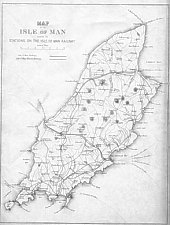
Map
of the Isle of Man showing the Stations on the Isle of Man Railway, 1875Map
of the Isle of Man showing the Stations on the Isle of Man Railway, 1875
Map
of the Isle of Man showing the Stations on the Isle of Man Railway, 1875Map
of the Isle of Man showing the Stations on the Isle of Man Railway, 1875
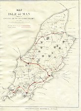 1875 Brown's Guide |
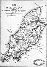 Post 1886 Album |
|
All 185 x 130mm
The progenitor of this map,commonly found pasted on the inside rear cover of the several Leporello Albums produced in the 1880s and 1890s was I think that used in the 1875 Brown's Guide.
The outline of the Island follows the O/S map though there are some strange features in some roads starting or going nowhere - all states show the lines to Peel and Port Erin (opened 1874) but early states show a proposed route, via Rhenas to Kirk Michael which was indicated on several maps from c. 1870 - this explains the strange Rhenas station supposedly serving Glen Helen. Later states have this line erased and the actual line as built marked though incorrectly in places as it was always to the northern (or sea) side of the road from Kirk Michael to Ramsey. Susequent states add the 1886 Foxdale line; later states add the Manx Electric Railway of c. 1893, at least as far as Laxey, though usually following an incorrect route. Later states complete the MER to Ramsey and add the Snaefell mountain line.
The version illustrated centre, is from one of the later albums, the New Album of 50 Isle of Man Views, which would appear to have been produced for the 1895 season, which though including a retouched photo of the first station at Laxey for the mountain railway does not show it on the map - the MER route is also incorrect.
The rightmost version is has the correct line for the MER but the incorrect line for the earlier MNR
The Brown's Guide has, below the border, an Imprint "James Brown & Son, Printers, &c., Douglas" - the centre version has the seal of John S McCann, Liverpool as publisher but others appear without any imprint - it's not clear that Brown's were the actual owners of the plates. The base map was never corrected, the dotted line of the projected line from St Johns to Kirk Michael with a station at Rhenas is visible in all states, that of the projected line to Laxey starting at the south of Douglas bay with a station at Tromode has been mostly erased in later states though the station symbols at Tromode and Onchan remain - all changes appear to be changed on the Litho stone.
The text below the scale bar for the 1875 reads:"Isle of Man Railway shown in red" with an overprinted, in red, solid line and "Proposed Railways" dashed line again overprinted in red - by the final state shown on the right this text has been changed to Isle of Man Railways - the s in a diiferent font and Isle of Man Electric Railway with a dotted line.
Brown's Guides 1875 onwards
Various Leporello Albums
Possibly as loose maps.
|
|
||
 |
||
|
|
||
| Any comments, errors or omissions gratefully received
The Editor © F.Coakley, 2006 |
||