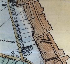
Sand street ran along the old sea shore here running from Well Road Hill at top to Drumgold street at bottom of plan
- the buildings to the east were on relaimed land, those on the right were originally part of Ballakermeen quarterland.
|
The area in blue is the higher ground now Finch Road - Sand street ran along the old sea shore here running from Well Road Hill at top to Drumgold street at bottom of plan - the buildings to the east were on relaimed land, those on the right were originally part of Ballakermeen quarterland. |
The first break away from the immediate vicinity of the harbour was along the shore of the Bay, a development which is mentioned in the Manorial Roll of 1703 under the name of 'the Sandside'. Duke Street in which there were buildings in 1801, led northward as far as Drumgold street, and then as the building of houses further and further along the shore went on - at the foot of Drumgold Street it joined the Sandside, and the junction to this day displays the break in alignment which earned for it the name of the 'Devil's Elbow' by which, it is still known to many people. Until it was straightened out in 1885 the road was, at this point, no more than seven feet wide.
By 1806 the Sandside had become Sand. Street or Strand Street, for both names were used, though the former did not persist after about 1840.
Many of the houses in this street are still standing, though all of them(with the exception of a few hotels) have become shops, and all have lost the thatched. roofs which some carried until as recently as c. 1860.
But under, the cement and the paint a close look at chimneys and the bits of wall exposed here and there will disclose the rough stonework of their builders. In the early years of the nineteenth century many of them were still private houses, though the occupants of them had already turned their ground floors into some sort of shop, above which they continued to live, as many still do.
The street boasted several old inns, but though the names of some them are still displayed the buildings which now carry these names show little or nothing, of their age. One of them, however, is remembered for the amusing sign under which it did its business. This is the New Strand Inn, which until 1875 was known as the Labour-in-Vain and bore a sign which depicted two white nurses kneeling beside a tub from which an infant, black as coal, was struggling violently to escape from their efforts to make it look like a normal Manx child.
The houses on the seaward side had gardens which extended down the shore. These gardens were divided from the sands by walls, and a length of one of these walls - still showing the 'bullnose' which protected it from breaking waves - may be seen in Strand Lane, at the back of the Loch Promenade Methodist Church. A little further along, in Castle Street, it is said that the back doors were placed well above ground level, and that when an easterly pale was blowing the householder gained admission to his house by means of a ladder which he drew up after him before barring the door to make himself safe from the raging waves.
Many of those who dwelt in it appear to have been of the roughest type, and the records of the times show them as being frequently in trouble with the police, while the 'Ladies of the Sandside' in particular bore an evil reputation such as would have made them unlikely guests at a Methodist tea-party.
From both Duke Street and Strand street slips led down to the shore where Regent Street, Howard Street and Granville Street are now found. The first of these was known as Callows Slip. And there were yet others at the foot of Senna Road, and at where Christian's little tripe shop, with its frontage of less then ten feet, is now to be seen wedged in between the Globe and the Old Strand hotels. Here the narrow passage beside the shop has a visible stone floor which may well be a part of the old slip.
From the Howard Street one a narrow passage beside the Strand Cinema led back to Cattle Market (now plain Market) Street This passage is now dignified with the name of Arch Lane, its older and less euphemistic, though probably more descriptive, one of Guttery Gable having been changed some years ago.
The name of Senna Road, referred to above, is an unusual one and the origin of it is unknown. But a possible explanation was put forward by Mr. Frowde who had heard it said that before the making of Wellington Square and Chester Street there were, at the top of the steps in Frederick Street, three cottages. In one of these cottages lived a family the mother of which was said to have come from the village of Senna in Cumberland. She may have called her new home in a strange land after her birthplace, and the name would naturally become attached to the lane which led to the cottage. He had, I think, no proof of this and it is unfortunate that the present writer cant find any trace of such a village . Perhaps it was a mistake for Zennor in Cornwall.
Strand Street went no further northward than the foot of Well Road Hill, where there was a field in which in a flock of sheep was offered for sale. This field would be part of what was known as the Big Garden ( ) and between 1818 and 1833 as Heywood's Garden . This garden ran upwards from Castle Street, between Well Road Hill and Senna Lane, and embraced Wellington Square. It was well stocked with fruit trees, and the old house - a large one with stabling and cow-houses - to which it was attached stood just opposite Well road Wesleyan Chapel (built 1836 but since altered) (and was described when offered for sale in 1828, as a desirable residence for a person fond of gardening and retirement. These would be strange words with which to describe the neighbourhood nowadays.
When Castle Mona wan built in 1802 Strand Street was extended towards it, and by 1810 this extension was then called Castle Street.
Behind Strand Street, and parallel with it, is Market Street - which Taggart's plan of 1834 shows as Cattle Market Street, though there is no written record of a market (cattle or otherwise) having been in any way connected with it. Half way along it, however, opposite Arch Lane ('ex Guttery Gable) is a smithy, a most unexpected sight in a street which is rapidly becoming the centre of the Island's motor-cycle industry. Here the smith,an elderly man busily engaged in shoeing a horse, assured the writer that "of course there used to be a cattle market in the street, it was in that very building, next door." and who should know better than he, who had worked there all his life.
Serving a strictly utilitarian purpose nowadays it is probable that but very few of the thousands of visitors of visitors who pass along Strand Street, a few yards away, are even aware of the existence of Market Street and its smithy and, indeed, it has nothing to commend it to the view of a stranger. But the resident will recall that in 1832 it was here that the cholera raged in its most virulent form. And he will note with interest the building - since used as a Club Room and a Rifle Range etc. which (erected in 1837 but altered and improved in 1860) was the Infant's School and Sunday School connected with St.Barnabas' Church,
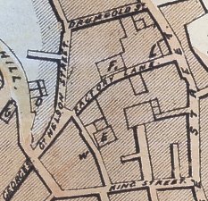 |
Taken from Sherwood's Plan 1849 - E is the Wesleyan Methodist Chapel(in Thomas Street) , F the Primitive Methodist Chapel, G the Roman Catholic Church (St Francis Xavier at top of Athol Street, L the 'new' Market, O the Bank of Mona, and W the Post Office (in Post Office Lane) |
Market Street continues as Nelson Street which, instead of ending at the foot of Prospect Hill as one would expect, crosses the busy junction and continues for a few yards more under the same name. This short length of street used to be called Great George Street, and was of considerable importance as before the making, of Prospect Hill c.1815 it was the direct line of communication between the northern end of the town and Church Street, which led out to the country. In it were the large houses of a Deemster and other prominent persons as well as a Bank etc. Where it joins Church Street almost opposite the Adelphi Hotel and against the side of the Police Station,la a clutter of little houses and shops which were built c. 1888 by a mason named John 'Happy' Quirk . He lived in the one squeezed into the back of the Police Station, and It was his 'coat of Arms' - implements of his trade - which is emblazoned above the door. The 'Happy' was a self-conferred name but a well-deserved one. At another time he lived in a cottage in Big Well Street (near the top, on the north side) which he decorated with a sandstone slab that proclaimed it to be 'The Happy city of Senna', a title which may have had something to do with his having, earlier still, been a resident in Senna Road.
At the corner of Nelson Street and Prospect Hill is the Westminster bank, a building which formerly housed the ill-fated Dumbell's Bank,the failure of which in 1900 caused so much misery throughout the Island.
Drumgold Street is referred to in 1789 (register of deeds) as Redcross Street, but the origin of this name is unknown. By 1816 it had. become Drumgold Street,a name said to be derived from James Drumgold 1, who arrived from Northern Ireland at the end of the eighteenth century, and whose daughter married the grandfather of the Rev. T. E. Brown. In it the houses, though small, had gardens. Tradesmen lived in them, together with others somewhat higher in the social scale, such as merchants, clergymen and Mr. Cleator, the Chief Constable while in 1823 Mr. Smythe had an Evening School there for young persons of both sexes who, as he was careful to explain, would be taught in separate apartments.
The area around Drumgold Street - which connects Market Street to Strand Street -, and Wellington Street - which links Nelson Street with Duke Street -, still retains a distinct atmosphere of the past despite the tact that in recent years so many of the houses have been altered beyond recognition, or else demolished and replaced by others. But look at the roofs of those which remain, and at the end of Market Street at its junction with Drumgold Street where - even though the wall of the corner house has had a piece carved out of it - not more than eight feet separate it from the tall, narrow house opposite. This house, incidentally, was in 1857 the Shepherd inn, and when rain has wet the walls the name may yet be seen through the paint which covers it.
Wellington Street has been known by two other names. Here was the factory of a branch of the Moore family, by whom flax was dressed, sacks and sacking made, and linen spun and woven at least as early as 1793. By 1829 cordage and canvas were added to their output, and sails made from the latter billowing from the mast of many a fine ship carried the name Moore across the oceans of the world. The original works of Edward & James Moore were in Duke Street, but in 1814 the partnership between these two was dissolved and, while Edward remained in Duke Street - where, it is said ( ) that in 1816 he employed between four and five hundred people - James opened a new works, and the road leading to them became known as New Factory Lane. In this road also was the Primitive Methodist Chapel, and because of this it was sometimes known as Preaching house Lane. The chapel building is still there: one glance at its exterior shows unmistakably what it was, but a look inside tells another story, for its congregation having moved to a new building in Thomas Street in 1816 it became a bottling store for a firm, of Wine and Spirit merchants. The new building in Thomas Street was in its turn abandoned when the present Victoria Street Methodist Church was erected within a few yards of it at the Junction of Thomas Street and the by now much more important Victoria Street - a fact which accounts for the change in name . When this happened the old building became the Church School, and later still the Church hall. This new church is said to have had an unfortunate start. It was to have had a lot of mahogany work in its interior, and a messenger was sent across with the money to pay for this. But the vessel on which he travelled was wrecked, he was drowned and the funds he carried were lost. ( .)
But to return to the chapel in Wellington Street. Next door to it is that comfortable little inn the Theatre Royal. This has long outlived the theatre which at one time faced it across the street (see page []) and from which it derived its name. But on the walls of its bar-parlour may still be seen many old play-bills which enshrine the names of actors and actresses who trod the stage of the nearby theatre, and no doubt enjoyed a welcome at the inn when the play was done and the curtain rung down.
The two earlier names of the street gave way to that of Wellington Street after the Wellington Market Hall was built on the north side of it at its junction with Duke Street at the end of 1836 . This was done by a private Company in the hope that the use of it would, do away with the many inconveniences and abuses of the open markets. But it never became popular, the country people refusing to pay the small fee charged for the use of a stall, and the public preferring to buy in the place to which they were accustomed . Stretching along Duke Street from Wellington Street to Drumgold Street the lower portion, after its failure as a market, was converted into shops while the upper floor has since become a cafe.
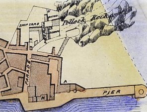 |
Taken from Sherwood's Plan 1849 Fort Street runs E-W at top, all to north and to west of Parade is on reclaimed land |
June 1837 saw the accession to the throne of the young Queen Victoria, but it found Douglas still without the right to the civic self-government for which its people has petitioned in 1834. What did the town look like in those early Victorian days ? First, and most important there was the harbour - the heart and centre of the whole place. Although no plans exist of a date early enough to show it exist, it would appear that in its natural course the river which flowed through the harbour entered the sea where the Swing bridge, completed in 1890, now stands. From this point, later known as the 'Double Corner', the coast swept northward along the line of the Parade and Fort Street until it merged with the beach as now existing near the end of Regent Street. About 1750 however wishful for more wharves, but having reached the river mouth and having no further land upon which to construct them, the local merchants built a solid pier, or mole, out as far as where the Imperial buildings 2 now stand, and it was at the end of this pier that the harbour then terminated and the river entered the sea. But in 1787 much of this 1750 pier was destroyed by a violent gale, and succeeding storms soon demolished the remainder of it. Six years later the building of a new one was begun. This was on the same site as the former, but longer and of a more solid construction . Built under the direction of Mr. George Stewart (who later built Castle Mona) it was faced with blocks of red sandstone imported from Scotland. It soon became known as the Red Pier and survived until, to meet the need for deeper berths and better facilities, it was decided to reconstruct it. This work, begun in 1929, involved the removal of the circular end which had served as a Promenade of which the towns folk are said to have been so proud that ladies were made to remove their pattens (then generally worn in wet weather) before being allowed to make use of it. The lighthouse which adorned the pier had also to go, coming down in 1930 and the work was not finished until May 1936,by which date Victoria being no longer alive it was named after the new monarch King Edward the Eighth.
Between these two points (the head of the Red Pier and the shore et the end of Regent Street) and to seaward of them, were the Pollock 3 Rocks upon which the fort stood, and which in later years became the base of the Victoria Pier (opened 1.7.1872). Behind the Fort in the bight caused by the changed course of the river new land gradually accumulated, so that beach which had formed one side of the Parade, and upon which fishermen had hauled up their boats and mended their nets, was forced further and further seaward. In 1758 part of this land became the property of Sir George Moore, S.H.K. who, with others, erected various buildings upon it. Later still further building took place there, and the Parade became a street having houses on both sides.
The Stone bridge did not then exist. Above where it now stands there appears to have been a sandbank around which the river - having passed through a shallow lake bounded by the higher ground along which Peel road runs on one side and that on which the Nunnery stands on the other - found its way to the sea.
From the head of the harbour started two of the three main exits from the town that for Peel going along the north bank of the river and that for Castletown along the south bank. To reach the latter the river had, of course, to be crossed, and our earliest view of Douglas - that drawn by Daniel King in 1656 - shows the simple footbridge which was in use at that date.
This would appear(though it cannot be said for certain) to have spanned the deeper branch of the stream to the aforementioned sandbank, from which the shallower branch would be crossed by stepping-stones. The exact position of this bridge, or perhaps of a replacement referred to in a Diocesan document of 1738, may be found by crossing the present bridge and then, after turning to the right, going along, the Castletown road for a few hundred yards to where a small, semi-circular bulge in the wall will be noticed . Look over the wall at this point and there, below, is all that remains of this ancient bridge - a few stones of the last broken arch.
The present bridge - long known as Qualtrough's Bridge, from the mineral-water factory which stood at the end of it - has had several predecessors. A picture painted in 1779 by Mary C. Stewart depicts it as being of stone, but having its two arches badly broken. It must have been repaired or rebuilt soon after this for Walker Smith, who depicted it in 1796,shows it in good order. It would seem to have been again damaged in October 1796, for Feltham - who saw the ruins of it in 1797 - not only states that it was then that it collapsed owing to a high sea acting on some floating timber, but expresses his surprise on learning that a man who was on it at the time it was swept away was saved by the astonished spectators. Though rebuilt it was evidently not satisfactory for in 1799 it was widened. (Highways A/cs.),while in 1818 4 a new one was built. It was, presumably this one under which in 1823 a post-chaise returning to Douglas from Castletown and being driven into the stream at the usual place for washing as a time when the river was unusually swollen was swept, turning madly over and over, into the harbour beyond. In 1842 it was widened to eight feet, and finally, as a tablet or the bridge tells us, in 1937 it was again rebuilt and widened.
1: J. J Kneen , Place Names of the I.O.M
2: These were erected on the site of the old Court House - a long, low one-storied building - which was in use until its
functions were transferred to the new Court House in Athol Street in 1846. Attached to it was the Black Hole,a temporary
prison for minor offenders and those awaiting removal to Castle Rushen. In 1861 the Imperial Hotel was erected here,
but in 1914 the building was taken for use as offices by the I.O.M. S.P. Co. in place of one located a few yards nearer
to the base of the pier on a site which then became a cargo shed.
3: The pollack (Gadus Pollackius) is a member of the cod family which is frequently caught when fishing from such rocks.
4:A. W. Moore History of IoM
|
|
||
|
|
||
|
|
||
| Any comments, errors
or omissions gratefully received The
Editor HTML Transcription © F.Coakley , 2016 |
||