[From Douglas by N Mathieson in draft.1961]
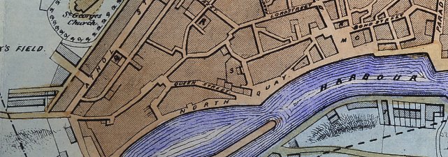
Midway between the head of the harbour and the Market Place is Queen Street. This is another of the few bits of the old town which still remain, though it needs a considerably vivid imagination to see it as it must have appeared when its houses were built about 1805 or shortly after, at the time when Queen Charlotte (the consort of George III after whom we may presume it was named was on the throne.) Most of its houses have been refaced, cleaned up and modernised, but a close inspection shows some fine old doorways which have been left untouched, And this street has been the scene of exiting events. In 1833 a fire which started in a bakers shop here threatened to destroy the whole town, for a store of timber and tallow which stood nearby was soon ablaze, and a stiff breeze spread burning fragments high over the roof tops. A rumour of what was happening having reached the worshippers at St. Barnabas' Church they one and all rushed in confusion through the door to join the large crowd already on the spot. Deemster Heywood, who chanced to be amongst them placed himself in a commending position and took charge of operations. The town fire-engine was soon dragged up, together with the one belonging to the Sun fire Insurance Co., and plenty of water being available near-by the blaze was extinguished in a few hours. Between Queen Street and Hanover, Street was the cattle market (marked S on the plan), while another one known as St. George's Market - was at the end of Hill Street, opposite St. George's churchyard.
At the point where Queen Street debouches onto the quay is another old Douglas landmark. This is the Saddle Inn, which was first licensed under that name in 1834 but had been an inn before that, while a date on a water-spout high up on the side of the building opposite to that on which the great sign swings, indicated that it was built in 1819. In its day a popular meeting place for farmers, the old stable-yard, which was at the side, has been roofed over, and a snug parlour occupies the space which once echoed to the thud of horses' hoofs. On the first floor, at the head of the stairs, a large room spans the full width of the house. It is a lofty and spacious room and, standing in it one realises that guests of the Saddle lived in considerable elegance.
The little, low building - now a news-agents shop - on the opposite corner was also at one time an inn. Known as Cannell the Liver's it was so called from being kept by a man named Cannell who was also the skipper of a trading smack named after the bird from which Liverpool is reputed to take its name.
Another hotel on the Quay is not as old as its black and white timbering might lead a stranger to believe. That is to say the present building is not, for it was erected as recently as 1894,but it takes its name from a much older one which was for many years the best and most prominent hostelry in the town. This, opened in 1809 and named the British, stood in the Market Place on ground now covered by the meat market, and stretching back to James' Street. Attached to it was its Assembly Room, much in request for social events of every kind. In 1894 it was demolished to make way for the covered meat market then about to be built. At the same time the Cheshire Inn, which had stood a few yards to the westward of it, was likewise pulled down and a new hotel built on its site . The new one, though as far as is known it had no connection with the British, assumed its name and still bears it
None of the long line of hotels(or drinking houses) which at one time stood shoulder to shoulder along the quay on the land now occupied by the Bus Station exist any longer; but go round behind the Clarendon hotel which, having been the printing office of J. Quiggin of the Manx Sun, and later occupied by Sam. Harris ( the draper whose son became the High Bailiff of Douglas)became an hotel in the second half of last century. Then note the little, low building with the dormer windows which is now the Clarendon Bar but was once the well-known Mahogony Bar. This notorious tavern faced New Bond Street, a typically narrow old Douglas street of not more than twelve feet wide, as is shown by the line of the old pavement marking the other side of it, still clearly to be seen.
The eastern end of the quay was known as the Fairy Ground. Here, in the small area covered by the modern Bus Station, was a confused mass of narrow, twisting lanes through which a stranger found it difficult to find a way, for until about 1810 many of them were unnamed and until 1829,when a few flickering oil-lamps were installed 1 none of them were lit. Various ale-houses welcomed the sailor ashore on a spree, and offered good cover from Press-gang or Revenue men. These lanes were not levelled, but followed the natural undulations of the land or. which they were built, and were unflagged - though here and there roughly surfaced with loose stones gathered from the shore. Now the whole place - picturesque but filthy - is only a memory, for it was demolished in 1932/34 and the teeming life it harboured is no longer to be found there. And Douglas is the better for the change.
The name of "Fairy Ground", which is not found in print before 1833, does not appear to have had. any connection with the 'wee folk' but probably arose from the fact that in ancient times the town Fair was held on this site. This Fair, mentioned as early as 1733,was held on November the eleventh (Old Hollantide) and, though early nineteenth century newspapers describe the business - mostly in cattle - which was done at it; the large number of pretty girls from the countryside that attended it;and the general jollity that prevailed; nowhere is there any indication as to exactly where it took place.
In 1833 we are told that the Hollintide Fair has been transferred from Athol Street - where in 1831 there had. been complaints of it having been an inconvenience to those residing; in that street, which was then being built - to a field on the Hills estate called the Camp Field. which was on land now (approximately) bordered by Princes Street and Allen Street 3 . It was still held on this site in 1834 2 but, though well attended, little business was done as the primary object for which it was intended the buying of cattle by householders Be a winter store of food - had passed away with the advent of butchers shops, and it was now used more for fixing the price of grain, hiring farm labourers and affording recreation to both farmers and men. And as it was in this year of 1836 that the Adelphi hotel (or rather its forerunner the King's Arms) was opened in a house, previously the residence of Mr J .N. Smart, which stands in Church Street, opposite the end of Nelson Street, it was doubtless then that the change of venue was made. And now the Fair, though officially proclaimed every year, no longer takes place.
The Parade( which runs past the end of the bus Station) at first as has been said had buildings on its town side only. One of these buildings is now the Freight Office of the I. O. M. S. P. Co. Originally the town house of the Bacon family (later of Seafield, Santon) and, very possibly, of the John Joseph Bacon who owned the brig "Caesar" built in Douglas in 1783 , The "Caesar" was one of several vessels which Bacon owned and in which he exported to the Baltic, the Mediterranean and elsewhere cargoes of the herrings cured in the Douglas herring-houses. Facing up the harbour as it does, he must, whenever any of his ships were in port, have had them well under his eye. The exact date at which the house was built is not known but though it must have been later than 1789 - when Fannin's plan of the town shows herring-houses on the site - it was probably not much so. In July 1837 it became the Royal Hotel 4 and through the red sandstone pillars of its doorway there have passed many visitors. One of them was the famous writer George Borrow, who arrived in August 1855. He praised its catering, noting that he had "a first-rate breakfast of lobsters, herrings in vinegar, eggs and fowl, white and brawn bread and bitter and. tea'". For dinner there was "soup and fish, followed by lamb at the top of the table, ham at the bottom, chicken and ham before me and ducks opposite; vegetables not particularly good, sherry very good and port so-so". Despite this excellent treatment of its visitors the Royal closed its doors as an hotel sometime about 1890, and since 1914 has housed the office of the cargo service of the I.O.M.S.P.Co.Ltd.
A few yards from this office, low down in the wall of the corner building, at what is known locally as the 'Double Corner' there is still to be seen the old milestone which shows the distances to Castletown, Ramsey and Peel. It bears no visible date, and the carving upon it cannot be made out, though it has recently been suggested that it may represent the child in the eagle's nest, which was used as a device by the Derby family. This 'Double Corner' has also been known as 'Blore's Corner', so called from the owner of the tobacco shop - the Cigar Chest - which stood there, its doorway adorned with the gigantic wooden figure of a Highlander.
And here was the Customs shed, with its triangles from which there hung the scales used for weighing the hogsheads of sugar, chests of tea and bags of coffee etc. To this spot were rolled the casks of rum and other spirits, to be measured and sampled for alcoholic strength, a job done in the open, where all who cared to do so might witness it and regale themselves with a good sniff of the delectable odour.
 |
Extract from 1849 Plan |
Near the northern end of the Parade was the Fort. This stood at what is now the south-west corner of the Victoria Pier Arcade, opposite which is the Peveril Hotel 5 . The spot, now part of the roadway, is marked by an inlaid metal triangle. Denton, writing in 1681, described this fort as being like a little pinfold or a large Lime-kiln, with a few guns and a fewer persons to guard them', but an inventory of the contents, taken c.1694,enumerated:
1 Sacre on a carriage
1 Minion -do-
1 Pounder -do-
4 Patteraroes
4 Crowsfeet, of brass. and Demiculverins on carriages, together with 18 nine-pounders in the 'Coals House' though whether
these were actually mounted is not clear.
Blundel in 1648,recorded that the guns were four in number, while the permanent garrison consisted of a Constable, a Lieutenant and nine soldiers, two of whom, with the Lieutenant, mounted guard every night; while four local men kept watch on the ramparts, where there was another gun. In 1793 it was stated to have been in use as a 'lock-up' or temporary prison, but in 1816 it ceased to be used and was demolished, only the walls being left. These walls, which had a diameter- of about ninety feet, could still be seen up to 1869,when they were incorporated in the approaches to the Victoria Pier which was then being built. At that time the area which they enclosed was filled in and the walls themselves were cut down to the level of the roadway.
At its northern end the Parade joined Fort Street which, instead of finishing (as it now does) at Lord Street - not then built - continued towards the Fort until it passed the end of the Parade and became Bath Place, which, of course, gets its name from the public Bath which stood there from Here also, on land now covered by the luggage depot of the Steampacket Co. was that joy of all Douglas Children Harmston's Circus which started in Hill Street in 1882 and was transferred to Bath Place in [].
Before Victoria Street was cut across its middle section in 1875 Fort Street, in a fine sweep, ran parallel with the shore from the Parade to where it reached the beach at Callow's Slip. This slip, one of several which ran down to the harbour from Strand Street, has now become Regent Street.
One of the oldest streets in the town, Fort Street in the early years of the nineteenth century was a popular place of residence amongst merchants and other people of good standing, as well as of several schools. The houses in it had - as an advertisement for one of them which was to be let in. 1815 termed it - 'a beautiful prospect of sea and land', while in it was the Assembly Room in which Balls and other social functions were held. By 1812 however fashion had deserted it in favour of the Rooms attached to Dixon's British Hotel in the Market Place, and the Fort Street building came into the hands of L. Lane, who used it as an auction room, and later, naming it the Birmingham House,turned it into a sort of News Room in which he held concerts and balls etc. until at least as late as 1835. Standing, as it did, almost on the beach, the Fort Street Assembly Room was separated from it by a narrow strip of garden which was protected from the waves by a wall with a 'bullnose' to prevent them breaking-over it. This was still to be seen until circa 1955 when, the need for it no longer existed, it disappeared in alterations made when the premises become the Salisbury Garage, or, rather, the ground floor did; for the upper floor, which had been the assembly Room was turned into a carpenters shop.
Next door to this (towards Lord Street) was an unusual looking building known as the Frenchman's, or Flemish House's name by which it is referred to in newspapers of 1814. With its corbel-stepped gables it was certainly of a design unique in Douglas, perhaps Continental or, it may be Scottish. Who the builder was is not known, and as it was demolished c. 1955 it will soon be nothing but a memory.
On the other side of the street, opposite the Assembly Room, is all that remains of the church of St. Barnabas. This church was built in 1832 and consecrated on the 12th December of that year. Intended especially for the use of the poorer classes it rapidly became the rendezvous of the rich, who every Sunday flocked to it in their carriages. These created confusion in the narrow street, and it said that, the quarrels which broke out among the coachmen became so violent that a constable had to be stationed there during service hours to put a curb on the bad language which assailed the ears of the worshippers. This church was closed in 1959 and though the walls still stand the interior has been denuded of all its fittings.
At its junction with Cambrian Place, a yard or two before Victoria Street is reached, a tablet on the wall of the last house in Fort Street informs passers by that in 1882 Jane Moore Cubbin of Tremissary Lodge, Onchan, spinster, gave a house for the use of the poor of the town. It is still fulfilling the wishes of the donor.
Cambrian Place is a short alley - street would be too grand a name - of some half dozen tall houses which, at a distance of not more than four yards face, and always have faced, the backs of those in Duke Street. None of these houses now serves the purpose for which it was built, but in the first quarter of the nineteenth century, there dwelt in them an advocate,an organist and other worthy gentlemen; and it was considered to be a suitable location for the school for Young Ladies which the Misses Hillard conducted at No. 3. The sight of such congestion brings forcibly, home the living conditions of those days.
At the southern end is an open space, which now serves as the starting place for the Corporation busses to Pulrose. Here, until it was demolished in the 1932/3 clearances, was 'Muckle's Gate' this name, the origin of which is not known, though it is thought to go back to at least as early as the eighteenth century, has given rise to much speculation. It has been claimed that it represents the Norse 'Mikill Gata' or Great Read and, as such, was in Viking; times the entrance to the town. but, as Kneen observes in his 'Place Names' it is very doubtful if such a town existed in Norse times. Local folklore attributes it to a gigantic Scots cooper known as Muckle Ralph, said to be seven feet tall and of prodigious weight, who had his residence there; while Fred. Leach, who in 1912 published a series of charming sketches of the old town, declares that the name arose from the gate which hung across the entrance to the street, and that the remains of this gate ' were certainly to be seen there 'down to within living memory'. Something much more definite is the house, known as the Widow's House, which has its wall adorned with a representation of a remarkably well-fed angel carrying a scroll. This house, left for the use of widows of all nations ' in 1833 by a Mrs. Squire - whose residence it had been - was rebuilt in 1918 and modernised in 1969.
To the south-east of St. Barnabas' where 'or a short distance the old Fort Street has become part of the modern Lord Street, stands the Customs House. This building, originally a private house in what was then Moore's Place, had by 1833 become the Records Office. Later it served as the Police Station, and then as the office of the Town Commissioners who, after rebuilding it and adding a second story remained in possession until when the Town Hall was built in Ridgeway Street and the Customs took over the quarters of the Commissioners.
On the side of Fort Street opposite to the Customs House is a long white building which is now used by the Engineering Dept. of the I.O.M.S.P. Co. This was the first hospital in the town; for the temporary one established during the cholera epidemic of 1831 appears to have been set up in a cottage called Lough Ned at Oakhill, Braddan. The Fort Street one (which had three wards, for accidents only) (Pigot's Directory, 1843 ) was established in 1839 by the efforts of the Rev. Dr. Carpenter of St. Barnabas' and it performed its work of mercy here until the erection of Noble's Hospital at the top of Crellin's hill in 1884. Noble's having in due course been found to be inadequate the White Hoe site was purchased in 1887 for the building of an Isolation Hospital (opened July 1888) and when the present Hospital in Somerset Road was erected in 1922 the old one became the home of the Manx Museum.
At. the northern-end of- Fort Street, a few hundred yards before it reached its termination at Callow's Slip (now Regent St),was the Poor's House. This old building 6 is still to be seen a the end of what is now a cul-de-sac behind the poultry shop of Mr. Clucas in Duke Street and next door to the furniture Dept, of Mesers. R. C. Cain & Co. In its present form it is not at all noticeable but its weather-beaten: old walls and the ' bullnose ' about seven feet up on the northern wall, which was; designed to break the waves driving against it when the house stood exposed upon the sea shore are still eloquent of its age.
In Hanover Street (now Lord Street) was the Barracks which, together with another on the South Quay, housed during the eighteenth and early years of the nineteenth century the small detachments of troops stationed in the town. The spot is now covered lay the Hanover Street School, the exact position having been at the corner of Lord Street and the appropriately named Barracks Street. Here, it is said, the Officers had a good house with a garden around it, while the men were quartered in the little dwellings nearby in Barracks Street. At No.12 of this street is a covered passage which leads to a small court in which curious searchers will find a three-storied house. This is stated (by the late Mr. Wm. Cubbon of the Manx Museum) to have been the Officer's Quarters, but the old woman living in it in 1959 told the writer that during a long residence there she had always understood that it had been a hospital, and this appears the more likely statement.
Before Lord Street was made in 1932 the portion of it between Barrack Street and the top of Bank Hill used to be called Big Well Street. As to the exact position of the well from which it, obtained its name there is a difference of opinion. A respected authority on old Douglas (the late Mr. Wm.Cubbon of the Manx Museum) believed it to have been on the south side of the road near the top (or Athol Street end),but an official of the Borough Surveyor's Dept. states that it was in an enclosure beside the road on the north side, at the foot of a slight rise which begins about a third of the way along. Stated to have been a very deep one, built of masonry and with steps leading down to the water it was, before the days of piped water, a popular source of supply for all the neighbourhood. It is quite possible that the water from it was good. It is certain that it was in the midst of a populous area in which there were no sewers, and equally certain that in 1832 there was a bad outbreak of cholera which caused many deaths.
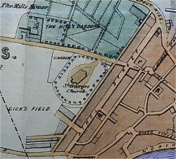
Prior to the accession of Queen Victoria there were - except for St.George's Church and the Hills House - but very few buildings and no formed streets, beyond the line of Athol Street and Finch Road, but an obvious route for westward expansion was the road of sorts which led past the house called Prospect Hill. Across this road an old resident of today recalls how in his youth he was told, by a man who remembered seeing it, that between 1830 and 1840 there existed a gate which had been erected to prevent cattle from the fields of the Hills estate from wandering down it into the streets of the town 7 .
The name of the house was an apt one for the eye of anyone gazing from it over the huddled roofs of the old town and the line of the harbour beyond would meet the lovely green and solid mass of the Howe, while before him he would see in the absence of large houses on the opposite side of the road 8 - the wide expanse of the open sea. With such a prospect before him well might he say, looking out on a sunny morning and quoting the words of the Prophet,' I will lift up mine eyes unto the hills from whence cometh my help' and, strengthened by the sight, descend in to the crowded streets to meet the trials of the day.
By 1815 a row of tall houses with grass-plots in front 96 had been built on the left-hand side of the ascent, and various members of the town's society (one of them was Sir Wm. Hillary Bt. ) were living there. These gentry had not far to go for company, for within a few yards were Shaw's Brow and Athol Street, in which many of the immigrants from England - some really members of good family, some pretending to be - who had at first tended to settle on the South Quay, had recently taken up residence.
Running along the very brink of the rising ground which marked the limit of the flat land around the harbour was Shaw's Brow. The row of tall houses extended westward from Church street to just beyond where the Lancastrian school in Athol Street was shortly to be built. At this point, in a little turning off it was a small cluster of houses named Athol Place past the entrance to which the Brow continued on to the top of Big, Well (now Lord) Street. On the patch of ground north-east of Athol Place,and between it and Barrack Street, was a locality called Thornhill. This as early as 1838 was known as Irish Town or Little Ireland and on sinking in the social scale as Little Hell.
The houses in Shaw's Brow, all of which had pleasant gardens facing the town and harbour, looked out on the other side across the open fields of the Hills estate to St. George's Church, the building of which had commenced in 1781. It must have been a shock to the residents in those houses, and to the little girls of Mrs. St, George's Academy for Young Ladies, who occupied one of them, when the houses in Athol Street came into being not more than a few yards in front of their windows, and their pleasant, rural outlook vanished for ever. They remained occupied, however, though by a different class of tenant, until 1958/9,when the whole long row was demolished to provide space for a. much-needed car-park for the many professional and business men of Athol Street.
 |
Extract from 1849 Plan |
Athol Street was built on ground which was a part of the big estate known as the Hills. Here building plots were being offered for sale in 1810,and within a year or two houses were already up and occupied; the Methodist Friendly Society had built their club Room and an Assembly Room had opened its doors. This Room - notice its windows - was on the top floor of what is now Johnston's Auction Rooms at the corner of St. George's Street, Opposite to it, on the other side of the street is an austere looking building designated Lancastrian House . The story of this one time school will be found narrated on p.
In November 1823 the principal proprietors of houses in the street determined to have it paved by the new method invented about 1815 by a Scot named J.L.McAdam, but this does not appear to have been done, for in December 1831 a correspondent writing to the Sun declared it to be 'entirely impassable to pedestrians as a result of the heavy traffic which made use of it' while a year later the editor of that paper waxed indignant at then state of the roadway in 'the principal and best-built street in the town' due to dainage done by builders conveying material to Finch Road and farmers carting seaweed for manure. It was, perhaps as a result of this that in January 1834 another Committee was appointed by the residents to arrange for it to be paved or macadamized. Five years later, however a newspaper article describes it as being, in such a state that ' as everybody knows it is scarcely passable'. but in April 1839 it. underwent a thorough repair and was, indeed, not only merely done with pitch but was this time, thoroughly macadamized 10.
The original buildings were almost entirely residences and, though some of them have been demolished or altered, the majority - now the offices of lawyers professional men or Govt. departments - still remain their steps worn thin by the feet of the anxious litigants who have trodden them for years, though the railings which once led up to their doors have mostly been removed.
Amongst some of the mere distinctive buildings which still remain and may be identified are the Court House and Talbot Chambers, The Court House was erected in 1840/1 at a cost of � 2,000 by the Independent Order of Oddfellows to accommodate their Douglas Lodge, but was also used for other purposes such as Dinners, Dances and Concerts etc. In 1846 it was bought by the Government who altered it into a Court House with a police station attached. Talbot Chambers - the massive yellow pillars at the door of which are so prominent - is said to have been built by a merchant of the name of Matthews, who used in the building of it, surplus stone offered for sale after the completion of Castle Mona in 1802. By 1883 it had become an hotel, and it continued to be one until 1898. In 1930 it was converted into the block of offices which it now is. Other buildings now serving purposes other than that for which they were intended are No. 16 (opposite the office of the Isle of Man Times ) which is now used as a store by Messrs. James Kissack, the grocers. This was originally the chapel of the Congregational Itinerant Society (alias Congregationalists, Dissenters or Seceeders). Generally referred to as the Independent Chapel its foundation stone was laid in June 1811 11 but it was sold when the Chapel in Bucks Road was opened, the bottom part becoming the printing office of the Mona's Herald and the top floor an auction room. In 1886 it became the Douglas Public Library.
No.7, now occupied by Mr. Johnston ('the Estate Agent) was the General Post Office from c.1860 until the building of the present one in Regent Street The earliest Post office had been in Post Office Lane which was demoltished 1832/5.This was the one which Dorothy Wordsworth, the poet's sister, who visited Douglas in 1828 described as being in a lane narrow as an Italian street, but the house low, cool and cleanly kept.
At No.55 Athol Street was the first telephone exchange in the Island. Later In 1897. it was moved to No 10. At No.15,on the corner of Church Street, was the Isle of Man Bank, as is shown by the Ordnance Survey of that date.
At the junction of Athol Street and Prospect Hill is St.George's Chambers. This building, now a block of offices, was originally put up by the Methodist Friendly Society c.1812 as a Club Room, but in addition to this it has housed at various times a Billiard Room, a Theatre, a Roman Catholic Chapel and a Methodist (new Connection) Chapel. When built it was said to be the largest public room in the Island. Its floor was about five feet above the level of Athol Street, and its door was approached by flights of steps from each side which converged opposite the door. When used by the Roman Catholics there was a house for the Priest next door on the south side. This had a little turret which contained a bell built on to its gable as the Chapel, it was understood was not allowed to have one. At a later date the floor of the room was lowered to within a few feet of the pavement and two or three steps led directly in to it from the street 120 .
Stretching inland from the line of Athol Street and Finch Road in three segments of a circle, close together at their eastern ends and gradually widening as they progressed westward, were the estates of the Hills, Ballakermeen and Ballaquayle. These might be said very roughly to be divided from each other by the Ramsey (later Bucks) Road and Ballaquayle Road.
On the left was the Hills estate, which had many years before run as far eastward as the river. This was the property of the More family,who were descended from Philip. Moore, a citizen of London, born 1650,who died in the Isle of Man in 1728. His eldest son, another Philip,(1675/1744) carried on a merchant's business in Douglas, and it was his eldest son, likewise named Philip,(1708/1788) who bought the Hills estate. Their residence (built c.1770) fronting on what is now Westmoreland Road and extending as far as Princes Street, covered the corner plots on the former road and the present
This latter road was so named because it led to the form of Ballaquayle, which had stood from early days 13 at what is now the Junction of that road with the one named York Road. In it was Stanley Terrace, which was in being at least as early as 1836,while as we learn from the O. S. map of 1867 - the top house in it was then the Stanley House Academy.
Circular Road did not come into existence until c. 1874. From here a private road -- now Upper Church Street - ran down past St. George's Church into the town . Until 1790,when the gardens through which it passed were closed to the public 14 this was a favourite walk for the inhabitants of the town, for the gardens - which in earlier days had extended almost down to the; harbour - were famous for their charm. In them were numerous fruit-trees of various kinds, and the song of birds was everywhere to be heard.
It was in this locality that some early expansion took place, when such streets as Hill Street, Hope Street and Myrtle Street were built in or, about 1855. For some years the latter two of these streets of rather pleasant little suburban houses - the homes of people who wished to breathe a purer air than that which circulated through the narrow streets of the old town - provided all that was required in that respect. But more and more were continually being celled for, and the need was met by the building of Princes Street, Tynwald Struet and Allan Street, and in of Demesne Road. though but alas, these streets were wider the houses in them were not nearly so pleasant to look at, and merited more the description - once applied to a certain London square - of being 'mostly brick walls with holes in them'.
 |
Extract from 1849 Plan The building, marked J, just N of Prospect Hill is St Andrews Church |
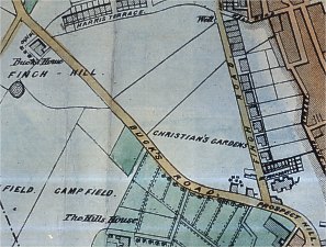
Bucks Road, which formed the northern border of the Hills estate, is thought to have obtained. its name from a certain William Buck, who is said to have built the first house erected in it, at about the spot where Finch Hill Chapel now stands 15. It has been suggested that this was the Wm. Buck, brickmaker who is mentioned in the Diocesan Register for 1807,but this is mere conjecture and, in any case, the name does not appear to have been applied to the road earlier than 1876,
Before this it is spoken of as the Ramsey Road, because after joining Ballaquayle Road it led by way of Onchan village to the road north. It may at first quite possibly, have been a mere track which led between the two estates, for Thos. Callister, writing in 1815 about Woodbourn House, speaks of the 'new road' near which that house stood. A more plausible story is that it derived its name from the Mr. Wm. Buck who married Miss Finch, the heiress of the adjacent Finch estate. .This property extended from Ballafinch farm (where the Government offices now are ) along Finch Road to the top of Well Road Hill. From there the boundary ran up to and past Mona Terrace to the top of Crellins Hill., thence up to Rose Mount and from there past the present Finch Hill Chapel down to Ballafinch again.
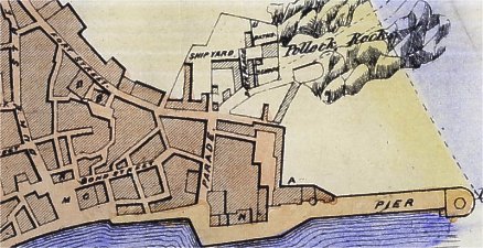
Starting at its lower end the road has on its left-hand side the Roman Catholic Church of St. Mary of the Isle. Built at a cost of �7,000 by Henry Clutton of London this was opened on the 4th August 1859. The Isle to which the name refers is said to be the rock, later known as Conister, on which the Tower of Refuge was built. These rocks, as the name (Kion-y-sker) indicates, form the seaward end of a reef - sometimes called the Pollack Rocks - the landward end of which is now covered by the Victoria Pier.
Further up the road, on the same side, is Rose Mount Methodist Church (built 1834) and several detached terraces such as Adelaide Terrace,(with the Rose Mount Hotel) the appearance of the houses in which now being spoiled by the addition of bow windows and new doorways to the austere but elegant fronts which they had when built, This may well have been some time in the 1830s, when the gentle and. loving consort of King William IV (1830/1837) was on the throne or, more probably about 1849 when she died. This lady was the 'Poor, dear queen Adelaide' who, as a critic of the said times has said "never did anything that history is aware of save hold her tongue and help the poor."
Next to these houses, and still unspoilt, is Stephen Terrace which, though short was originally called Stephen Terrace at one end, and Woodbourne Terrace at the other. This terrace, with its low roofs and gardens in front - a little bit of the country lost in the rapidly encroaching town - has a charm which, until they were felled c.1932,was enhanced by a screen of leafy trees, the stumps of which may still be seen embedded in the garden wall. The terrace; was built c,1834 by a Mr. John Stephen from whom it takes its name, but the earliest mention of the row of shops built as houses opposite, known as Prospect Terrace, is in 1856.
From the top of the road, turning, back towards the: town down the left hand side,we come at once to Woodside Terrace, another delightful little backwater the houses of which still have in their gardens fruit-trees whose blossom charms the eye of the passer-by, This appears to have been built about [] and was certainly it existence in 1874.
A short distance beyond it is the Masonic Temple built in [] on the site of Woodburn Lodge. the seat of Thos. Harrison Esq M.H.K. The first road leading, off on this side is Derby Road, known in its early days as Lover's Lane, and so envisaging a charmingly rural appearance to which it could certainly not lay claim today.
Derby Square was not all built at the same time. The western side - which is, in fact, Albert Terrace - was erected about 1847 (Johnson's guide 1847) after and it was here, at No.4, that George Borrow stayed after having spent his first night at the Royal when he visited Douglas (between the publication of Lavengro and The Romany Rye) in the autumn of 1855. The other three sides of the Square are of about the same, or perhaps a slightly earlier, date, the decision to form it having, been taken in April 1846.
Windsor Road, which runs parallel with it and may be dated in the main to 1855, was at first called Auckland Terrace, and until the 1870s had houses on the north side only. Along the whole or the opposite side was a high wall, the boundary of what, was known as Fargher's Garden. On the west side of this garden the wall extended from Buck's Road to where the lane now is just below the point at which Demesne Road joins Buck's Road. On this Garden there were built in 1879 the houses of the south side of Windsor Road and those of Richmond, Osborne and Kingswood Groves, together with the ones in Kingswood Terrace. The same date may be assigned to Dalton Street, including, Albert Terrace and the several other streets in that vicinity, including the long row with which Buck's Road itself is lined as far down as Christian Street but those from there on downward must have been built slightly earlier, as they appear on a plan of 1864.
Albert Street, Mona Street and Christian Street lead down from Buck's Road to Mount Havelock which,-built c.1864 was named no doubt, after the great English general Sir Henry Havelock, whose relief of Lucknow - where he died in 1857 - would be fresh in everybody's memory.
At the bottom of Bucks Road, opposite St. Mary's Church and on the corner of Finch Road, is the House of Keys and Government offices. These, built in [] were originally the premises of the Bank of Mona (a branch of the City of Glasgow Bank,which closed when its parent Bank failed in 1878). The building was taken over by the Government in 1894.
Finch Road took its name from a family named Vinch who had a farmhouse on the land where the Government offices where later built. A MS.plan of 1833 shows 'Mr. Finche's Road' as a track (or perhaps a projected road) on its present site, and the road was probably made in 1826 when the Commissioners of High Roads called for contributions towards the: making of a road 'from Athol Street to the Sand.' There is, however, no mention of houses being built along it earlier then 1832, though if those which were then built (as is probably the case ) the ones still standing they must have been very pleasant ones, and the homes of people of considerable standing. Like most houses now near the centre of a town however many of them are in progess of changing their character and being converted to commercial use.
In November 1831 a newspaper reports that it was blocked by a wall 'recently levelled near Finch's Well' (Sun 15 11 1831) This well, which had already baen mentioned in the March of that year, was an oblong, open tank into which the local woman dipped for their daily supply of water. It was later used to supply a Drinking fountain which may still be seen opposite the top of Well Road Hill 16.
Building, when it started, was fairly rapid, for in June 1835 there was offered for sale the last seventeen plots unbuilt upon' on the east side of the road. .
At the foot of Crellin's Hill {built in 1854}- down which there had at one time tumbled the stream ('now culverted) which, arising near Rose Mount had followed the line of Windsor Road until its waters, leaping down the steep descent, rushed to join the sea at Greensill's Corner - there stands a pair of ornate stone door posts which mark the entrance to a path which leads upwards to the Manx Museum. These posts came from the Market Hotel in Chapel Lane, when that little street and all the buildings in it vanished during the clearances of 1932/3.
Just opposite, but on the other side of Finch Road and sunk some feet below the level of it, is a row of houses and gardens the appearance of which excites the curiosity of many passers-by.. Named Edward Terrace and Callow Terrace respectively these houses appear to have been built some time after 1834 but before 1849.
At No.4 finch Road, not far away, John Martin, the painter, is said to have died (on 17.2.1854) while staying at the house of his brother-in-law, the Douglas draper Mr.Wilson.
Further down the road., alongside the Scottish Church of St. Andrew's is a quaint little backwater called Mount Pleasant, where the fanlights over the doors of some of the houses - being typical of the period at which they were built - are worth inspection. It was at this period also (the end of 1832) that St. Andrew's was built. This congregation had been started in 1817, in a small room in Athol Street, by Mr. James McCrone a Scot who was the IVth Duke of Atholl's man-of-affairs, and it must have been a great joy to him when, largely as a result of his energy and enthusiasm, the building in Finch Road was opened. As it happened it was in Finch Road that he met his death in 1848, when the horse drawing the carriage, in which he was going to his church bolted and he was thrown out.
At the other end of Fnch Road, just round the corner in Marina Road is St. Thomas' Church, which was opened on the 1st.August 1849 17 This Marina Road is associated in name with a row of four houses called Marina Terrace which stood close by on an extension of Finch Road-which led past the garden of the present Sefton Hotel to a gate giving access to the grounds of Marina house as it was originally named.
The houses in this terrace appear to have been built c. 1825 but are not mentioned after
On the land which rose sharply behind Finch Road there had been built by 1834 a row of houses named Mona Terrace and near, but at right-angles to them, another row which bore the name of Harris Terrace,
In the early years of the nineteenth century there was great poverty in the town, and except for private giving the victims of it had of course, nowhere or nothing to which they could turn for assistance. Charitable people did. what they could, while the Ladies' Soup Dispensary (founded in 1819) kept many from absolute starvation. But while some gave generously many, despite urging from both Church and Press could not be moved to help. Numerous meetings were held, and in 1835 as the outcome of one of these a piece of ground which had been a brick field near Harris Terrace was purchased for the building of a House of Industry for the reception of those willing and able to work. The land was somewhat larger than was required, but the surplus area was sold within a very short time, bringing in almost as much as much as had been paid for the whole. Cheered by this lucky stroke of business the Committee in charge at once started building, and in February 1838 the House of Industry was finished. and opened.
1 Handbook for Bazaar held 1897)
2 Sun 18 11 1836)
3 (Sherwood's Plan)
4(Manxman No 13 June 1914)
5 From the balcony of which Mr. Gladstone - who stayed there when he visited Douglas its 1878 - spoke to the great crowd which had assembled to greet him.
6 referred to as 'Lasnon's Concerns, in the Manx Mercury of 19 3 1793
7 (History of Rosemount Church R.B. Moore
8 Where Victory House now stands there was c.1810 a delightful little cottage in its own garden. (Monas Herald 26 7 1938)
9 These little gardens were swept away when the tracks for the cable trams were laid in 1898.
10 (Advt. Zf. 4. '39)
11 (Advt.-8 6:1811)
12 MS in the hands of R B Moore-)
13 For it is named in the Manorial Roll of 1511.
14 A. W. Moore Douglas 100 years ago 1904)
15 ( names. of the I. O. M. )
16 The actual well, which still collects water, is indicated by a metal plate marked 'Adam's Lift' which is let into the pavement.
17: Thwaites Guide 1863 p166)
|
|
||
|
|
||
|
|
||
| Any comments, errors or omissions gratefully received The
Editor HTML Transcription © F.Coakley , 2016 |
||