568 x 428 mm
568 x 428 mm
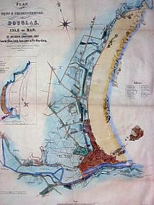
Plan of the Town and Neighbourhood of Douglas drawn by Richard Sherwood Jnr from the Plan lately forwarded to Sir Geo. Grey
Published by R.H.Johnson, Great Nelson Street, Douglas
G.Philip & Son, Lithog 51 South Castle St L’pool August 1849
Inset : Chart of the Bay and Harbour of Douglas with designs for Low Water Asylum Harbours
That proposed by Sir Wm Hillary being colrd green/Mssrs Rennies Red/Capt Denhams Blue”
J.Parris Surveyor”
Shows the development of Douglas with just a few houses starting to be built in what was to become Upper Douglas
|
|
||
|
|
||
|
|
||
|
Any comments, errors or omissions
gratefully received The
Editor |
||