 Edward
Weller, 1859Edward
Weller, 1859
Edward
Weller, 1859Edward
Weller, 1859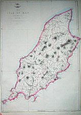
Edward Weller, died 1884, engraver, publisher and cartographer
London.
Tooley gives addresses as 34 Red Lion Sq (1861) and Duke St Bloomsbury (1872).
Originally issued as an insert in the Weekly Dispatch then collected with others as part of the Dispatch Atlas. Map had a long life - most were Lithographic Transfers at 1:115,200
John Cassell 1817-1865, carpenter, temperance preacher, tea and
coffee merchant and finally publisher.
The plates were acquired by Cassell, Petter & Galpin in August 1863 and
issued with the Family Paper - the start of Cassell's atlas publications. By
1863 John Cassell had only two years to live and played little active role in
the company which bore his name. Thomas Dixon Galpin and George William Petter
had been printers but on John Cassell's bankruptcy in 1855 had acquired the
publishing company - J.Cassell becoming a 'junior' partner after his bankruptcy
cleared in 1858.
Galpin was the astute business manager; George Lock (founder of Ward Lock) was
Galpins first cousin. Petter resigned 1883 (disapproval of publishing fiction)
and company name changed to Cassell & Co. in 1888 following Galpins retirement
and Petter's death.
La Belle Sauvage (at foot of Ludgate Hill) was originally an old inn (Mr Sauvage's
Bell ?) refurbished for the 1851 Great Exhibition by John Thornburn who rented
part out to Cassell ; premises completely destroyed during WW II.
Plates were later acquired by G.W.Bacon - though that of IoM was not used in his County Atlas nor in1886 (+later?) editions of New Large Scale Atlas of the British Isles as around 1888 this map was replaced by smaller map (Bacon 1888) included on Channel Is. plate. It however found life as part of Bacons series of county cyclists and tourist maps.
A: .A Size: 417mm x 286mm
Title: The Dispatch Atlas The Isle of Man by Edwd Weller F.R.G.S
Aa: emblematical design of upper half of globe with scroll "the
Dispatch atlas" and above a flying figure of Mercury.
Aa: title
Aa:scale
Aa:"The Isle of Man contains 280 square miles (179,200 Statute Acres)"
Ae (os): "Weekly Dispatch Atlas, 139 Fleet Street"
Ce (os): E Weller Lithogr
Ee (os): Engraved by Edwd Weller Duke Str Bloomsbury
(a) Embossed SUPPLEMENT TO THE WEEKLY DISPATCH OF SUNDAY Dec 25th 1859
Issued with The Weekly Dispatch of that Date
(b) without embossment no page number in type
The Dispatch Atlas
London: Weekly Dispatch Office 1863
London: Published at the "Weekly Dispatch" Office, 139, Fleet Street,
London, and sold by all Booksellers and Newsagents, 1863
Cassell's Complete Atlas London: Cassel, Petter & Galpin (1865)
Reference Chubb DLI Smith III (1)+(2)
B: Size: 417mm x 286mm 1:115,200
Title: The Isle of Man by Edwd Weller F.R.G.S
Mercury,scroll+hemisphere removed
Ab: additional typographical notes (type transferred to stone)
"AREA 180,000 acres or 281 Square Miles
POPULATION, CENSUS of 1861 ...
EDUCATION ... 23 are National Schools"
De(os):Imprint LONDON, PUBLISHED BY CASSELL, PETTER, & GALPIN, LA BELLE
SAUVAGE YARD LUDGATE HILL, E.C.
Ee(os): page number 56.
Maps of GB reissued in monthly parts from 1863-7 by Cassel Petter
and Galpin
Published collectively "Cassell's British Atlas" without date
Reference: Smith III(3)
C: Size: 417mm x 286mm 1:115,200
Title: The Isle of Man by Edwd Weller F.R.G.S
page number 95 sideways in type Ee(os) and on reverse
Railways: IoMRly + MNR ;Poortown stn wrongly indicated as St Germains, Sulby
Glen Station misplaced to previous road junction to West of correct position
Overprinted purple on blue?
1883 "New Ordnance Atlas of the British Isles"
Page number 97 sideways in type Ee(os) and on reverse
Railways: IoMRly + MNR ;Poortown stn marked & St Germains correctly indicated
Overprinted purple on blue
? 1884 "New Ordnance Atlas of the British Isles"
Page number 98 sideways in type Ee(os) and on reverse
Overprinted purple on blue
? 1885 "New Ordnance Atlas of the British Isles"
Reference: Smith III(7)
D: Size: 417mm x 286mm 1:115,200
Title: The Isle of Man
New table below scale: EXPLANATION showing symbols and populations
according to 1881 1891 censuses
1895 Commercial and Library Atlas of the British Isles from the Ordnance Survey..
Plans of Towns.. Edited by G. W Bacon F. R.G.S
1895/6/7 Commercial and Library Atlas of the British Isles from the Ordnance
Survey. Edited by G. W. Bacon F.R.G.S
E: Size: 613mm x 472mm 1:76,000
Lithographically enlarged forming part of Bacon's series of county cyclists and tourist maps
Title: Bacon's Map of The Isle of Man
All Rlys shown including Marine Drive
Mythical 'Caldon 1599' erased (above A of Glanfaba
Aa:inset 'map of the Irish sea showing the routes to the Isle of Man'
Ab:three column table of 'Popular Cycling Routes'
Ee:title;Reference Railways and stations thus ... Steamship routes"
Ee:Scale;"Hills to be ridden with caution ...Hills dangerous"
Ae(os)"The Copyright of this map will be strictly protected"
Ae(os)printer mark 18M10
Ea(os)"G.W.Bacon &Co.,Ltd.,127,Strand, London"
Bacon's Large Scale Map Isle of Man for Cyclists and Tourists In Cloth Case
6d. net,on cloth 1s net.
London:G.W.Bacon & Co.,Ltd,127 Strand.[c 1898onwards]
The same map is used (without Popular Cycling Routes)
Ea(os): "Copyright" + printers mark "34M20" in
Bacon's Large Scale Map Isle of Man From the Ordnance Survey of 1903 Main Roads
Specially Coloured
In Cloth Case 6d. net;on cloth in Case 1s net.
Specially prepared for the publishers of The Isle of Man Examiner Douglas &
Port St Mary
(note O/S survey was 1905 + issued in 1906 - as map was unchanged suspect just
a 'puff')
[London:G. W.Bacon & Co.,Ltd,127 Strand] [1905?]
F: Size: 425mm x 298mm 1:114,000
Lithographically reduced map
Title: The Isle of Man
Aa:Title + below "Railways and Stations thus..."
Aa:Scale
Aa:'The Isle of Man contains 280 square miles (179,200 Statute Acres')
All Rlys shown including Marine Drive
Mythical 'Caldon 1599' erased (above A of Glanfaba
EAa:title;Reference Railways and stations thus ... Tramways"
Ea(os)"G.W.Bacon &Co.,Ltd.,Norwich St E.C.4"
Bacon's Motoring and Cycling Road Map of The Isle of Man on cloth 1/- net [1910?]
|
|
||
|
|
||
|
|
||
| Any comments, errors or omissions gratefully received
The Editor © F.Coakley, 2006 |
||