 Robert
Walker, 1746Robert
Walker, 1746
Robert
Walker, 1746Robert
Walker, 1746
 |
 |
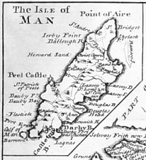
Based on Moll 1724 (including fenced mound of Tynwald)
Walker was a prolific publisher of part works, notorious for literary piracy.
three vols containing 41 maps. Most show arms of counties and frequently those
of chief towns and principal county families
Maps precede histories - plain at back, bears no pagination or reference
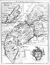
The Isle of Man - inset in "Cumberland"
7: pentagonal inset top lh corner in map of Cumberland
Ee: ornate cartouche `The Arms of Cumberland'
Chubb CLXXXIV
possibly published in parts 1743+
The Agreeable Historian ...
Advertised in The Universal London Morning Advertiser Dec9-12 1743
The Agreable Historian, or the compleat English Traveller: giving a Geographical
Description of every county in that Part of Great-Britain,called England.. With
a Map of every County.. after the Designs of Herman Moll and others.. by Samual
Simpson Gent vol l:
Printed by R Walker in Fleet Lane and sold by the Booksellers in Town and Country
1746
|
|
||
|
|
||
|
|
||
|
Any comments, errors or omissions gratefully received
The Editor |
||