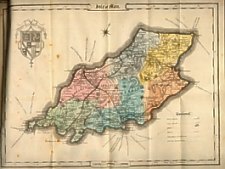
Thomas Johnson, Manchester publisher (atlas 1847)
Steel engraving - similar arrangement to Pigot's 1836 map though on a smaller scale, names of many quarterland farms on the map.
Used in Guide Books and as decorative map set within very decorative scroll work borders + also with different designs in top lh - Samuel Johnson (father of Thomas) used it in his editions of J. Brotherson Laughton's Guide Book from 1847, he also published it as a single sheet with the map surrounded by the small steel illustrations of Island churches and Chapels used in the 4th and later editions of that guide book..
(i)
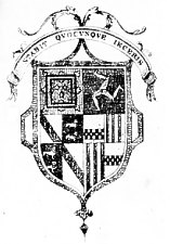
Arms used in 6th Edition
The arms are those of Duke of Atholl and Earl Strange
"A New Historical Topographical and Parochial Guide to the Isle of Man " 3rd Edition by James Brotherston Laughton BA pub S. Johnson Douglas 1847 (subsequent eds 4th 1848, 5th 1849, 6th 1850, 7th 1853, 8th 1854 and 9th 1858)
|
|
||
|
|
||
|
|
||
|
Any comments, errors or omissions gratefully received
The Editor |
||