 Saxton,
1579 +1583Saxton,
1579 +1583
Saxton,
1579 +1583Saxton,
1579 +1583
 Introduction
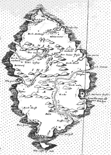
Christopher Saxton had produced between 1574 and 1579 a series of 34 county maps of England and Wales (which unfortunately do not include the Isle of Man) - when these were published in 1579 they included an overall index map 'Anglia' which used a similar, though much less detailed, representation of the Island.
This wall map of 1583 was produced from some 20 sheets clearly designed to fit together to form a wall map nearly 1.5m by 2m in size - an early state with border can be seen in Birmingham Central Library. A later impression (though still 1st state) is bound as an atlas in British Library (Maps C.7.d.7). The copperplate of the section including the IoM of a later version still exists.
Thus one could describe it as the first map purporting to show any
real inland detail of the Island. It would appear to have been drawn
by someone without any personal knowledge of the Island but working
from some (oral ?) description. No engraver is indicated but assumed
to be Augustine Ryther (see [Tyac80]pp39/43)
The Island shape is almost conventionally insular but does slightly indicate the N-S elongation - however obvious features such as Ramsey and Douglas bays and Langness are totally missing, although the relative placements of the major towns is correct, as are many of the Parish Churches. The central hill massif is also shown though the Dhoo and the Silverburn are however shown as a single river!
The settlement symbols : and
and
![]() are conventional symbols used elsewhere (and on the county maps) to
indicate towns and castles respectively; other places are indicated
by a small circle with a central dot. St Patrick's Island (Peel) and
St Michael's Island (Langness) would both appear to have a castle (or
fortification) symbol whereas one might have expected a Cathedral
symbol at the former. Ballasalla (presumably because of Rushen
Abbey) is the only town indicated as such - all other towns have
only a dotted circle.
are conventional symbols used elsewhere (and on the county maps) to
indicate towns and castles respectively; other places are indicated
by a small circle with a central dot. St Patrick's Island (Peel) and
St Michael's Island (Langness) would both appear to have a castle (or
fortification) symbol whereas one might have expected a Cathedral
symbol at the former. Ballasalla (presumably because of Rushen
Abbey) is the only town indicated as such - all other towns have
only a dotted circle.
The 1579 map had fewer names: St Andrews, St Michael (a misreading for St Maccul or Maughold ?)), Dowglas, Sct Michels Islet, Russin Cast[le], Bala[sala], the calfe of man, the pyle (Peel) and Balicurii (old name for Bishopscourt).
Interestingly the use of the Manx 'Kirk' appears in the 1583 map; Kirk Michael (and 'sedes episcopi' Bishops seat (Bishopscourt)) are shown in their correct relative position, the Sct Michael shown south of Ramsey is almost a certainly a misreading for St Maccul.
Saxton's maps are discussed in all texts on English map making - exactly how this major corpus (the wall map should be considered as an output of the same mapping survey) was accomplished within 5 seasons by the 30 year old Saxton is still a matter of debate. It would appear that some mixture of triangulation and traversal appears to have been used. There exists in a letter from the Privy Council to Justices of the Peace in Wales, a request that the bearer (Christopher Saxton) be conducted unto any high place or hill to view the country and to be aided by 2 or three local men who knew the neighbourhood. No roads are shown on these maps even though they would be essential to support any military operation - the maps appeared at the time of heightened Anglo-Spanish tension and were supported by Lord Burleigh for this purpose.
The plates for both the thirty-five 1579 maps and the 20 sheets of the 1583 wall map were acquired by Phillip Lea who reprinted from them many times - many of the county maps were still being reprinted well into the 17th century.
A copy of the wall map formed the basis of Jenner's 1644 Quartermaster map - the IoM, along with the Channel Islands and part of Lincolnshire was printed on a thin strip and thus is comparatively rare.
R.A.Skelton Saxton's Survey of England and Wales. With a
facsimile of Saxton's wall-map of 1583.
Amsterdam: Nico Israel (Imago Mundi Supplement No VI) (ISBN
90-6072-719-3) 1974
W Ravenhill Christopher Saxton's 16th Century Maps. The
Counties of England and Wales
Chatsworth Library (Shrewsbury:Airlife Press) (ISBN 1-85310-354-3)
1992 (a facsimile of Anglia and the 34 county maps; also gives a
select bibliography)
S Tyacke & J Huddy Christopher Saxton and Tudor
map-making
London: British Library (ISBN 0-904654-44-3) 1980 (includes
significant bibliography and reading list)
|
|
||
|
|
||
|
Any comments, errors or omissions
gratefully received The
Editor |
||