The Isle of Man
Size: 220mm x 160mm 1:266,000
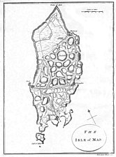
Outline probably based on Fannin though Ramsey Bay severely attenuated and internal details differ .NE to top - skewed shouldered shape - hills indicated as large circles with small hachures, though map has correct ratio N-S:E-W; many features poorly drawn, scale bar is 10% too short. Indicates Ramsay, Peel, Douglas and Castletown only + main roads 'drains' shown 'new drain' in NE corner. Calf of Man exaggerated
Published as part of a small pamphlet discussing among others possible improvements in drainage for the North
of the Island - the 'new drain' appeared on several maps in the following 30 years.
Imprint (os):"Neele 352 Strand" - same engravers who engraved the later 1812 map.
EMIoM p4
General View of the Agriculture of the Isle of Man with observations .. London C. Macrae 1794.
|
|
||
|
|
||
|
|
||
| Any comments, errors or omissions gratefully received
The Editor © F.Coakley, 2006 |
||