George Philip, 1840George Philip, 1840
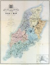
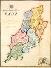
 Jefferson's New and Improved Map of the Isle of Man Published 1840 |
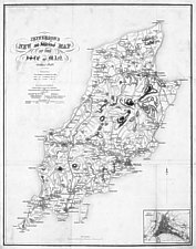
 A New and Improved Map of the Isle of Man Drawn from Actual Survey [c1852] |
|
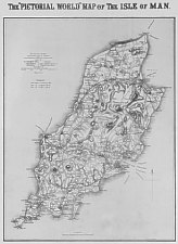 "Pictorial World" Map of the Isle of Man [1879 ] |
Note that the Island outline around the north west was significantly changed post the 1868 O/S map.
Although ascribed to G.Philip his name did not appear on map until the 1848 version. Appears to be first used by Jefferson where dated 1840 with his name in the title - later titles have the date removed and altered to "A New Map. from Actual Survey." The survey would appear to be that of Smythe of 1826.
Under Title is a scale Bar (Scale of Statute Miles 4) and list of distances and Explanation - in bottom right corner is a plan of Douglas.
The colouring if used can vary - the 1850 shown above picks out the Sheadings - a common scheme is sheading by colour outline
. Later versions add or alter the maritime links or distances
Longlived -used for Sunday Pictorial 1879 and also in Philip’s County series 1880 though a later map by Bartholomew
existed from around 1870.
Appeared in several guide books from 1848 onwards under its later title. The map is often seen removed from its original
guidebook.
George Philip took his son (George Philip II) into partnership in 1848 and the firm became known as G.Philip & Son.
George Philip II (1823-1902) according to family history [Phil34] attended King’s College IoM (King William’s
College Castletown ?) however no Philip is on record of the KWC’s pupils. (G.Philip came from a strongly non-conformist
background - 2 brothers were non-conformist ministers - so would be somewhat surprising that sent only son to strong C.
of E. establishment ?). G.Philip and Son opened their London office (32 Fleet Street) in 1856
There may be an earlier state dating around 1852 (imprint G.Philip & Son Liverpool)
G.Philip & Son installed steam driven lithographic presses in their new Caxton Buildings printing house in 1859 - the
map could then be more easily updated eg post 1861 Paths on Calf shown rather than hills (+ small corrections to Scarlet)
(following 1861Stanford ?) - Philips issued it as a separate Map in many forms. The Philip’s Popular Series of County
Maps seem to have been issued from c1866 onwards with one transfer daating from around 1880 as IoMRly + MNR shown - later
is corrected from Pictorial World issue though no stations on either line shown. Inset of Douglas present
Under Original Title - 1st & 2nd eds:Jefferson's The Geographical and Topological Guide. Embellished with a beautiful view of Douglas. Douglas: Printed and sold by G.Jefferson 1840
Under Title "A New and Improved Map of the Isle of Man Drawn from Actual Survey 1848" - A Handbook for Vistors to the IoM being a Pictorial guide to the Picturesque Scenery and Beauties of Mona Douglas by M.P.Backwell Published by George Philip Liverpool 1849 - imprint::”W.H.Lizars”[Manx Museum - F67.B1(2)]
A New and Improved Map of the Isle of Man Drawn from Actual Survey 1850 - probably Quiggins Guide 1853
A New and Improved Map of the Isle of Man Drawn from Actual Survey 1852 - A Handbook for Vistors to the Isle of Man being a Pictorial guide to the Picturesque Scenery and Beauties of “Mona” Douglas by M.P.Blackwell Athol Street 1854 [F67.B1(3)]
A New and Improved Map of the Isle of Man Drawn from Actual Survey - Backwell's Illustrated Guide to the Isle of Man, descriptive of its Towns and Villages, Scenery, Botany, Antiquities and other peculiarities, forming a complete key to the Island. Backwell M.P. Douglas: sold by M.P.Backwell Athol-street ;Castletown n.d. [1858]imprint: pub by G. Philip & Son London & Liverpool
Imprint Ce(os):”William Kneale, Duke Street, Douglas colour wash by sheading Kneales Guide to the Isle of Man, containing an account of the Island c1860
Imprint “George Philip & Son, London & Liverpool” (later Backwell’ guides ?)
New Tourist’s Map of the Isle of Man Drawn from Actual Survey - Issued as folding map on cloth in boards (inside cover gives Table of Distances) Price One Shilling
Philip’s Popular Series of County Maps Isle of Man with its railways Price sixpence London. George Philip & Son. 32 Fleet Street and Caxton Buildings.Liverpool & at all the railway stations
The Popular Guide to the Isle of Man [Brown's Guide 3rd Ed ] James Brown & Son Athol Street Douglas - 1877 uses this map (with railways but not the MNR) - imprint below map is James Brown & Son, "Times Office", Douglas [sheadings coloured with now significantly out of date Douglas plan still used]
[The "Pictorial World" Map of the Isle of Man .. July 26 1879] No title on Map (Title imprinted in bold type
above border)
Coast around Jurby Head smoothed (+ Ramsey harbour erased) + inset Douglas town from 1840 map removed, - Supplement to Sunday
Pictorial July 26 1879
|
|
||
|
|
||
|
|
||
|
Any comments, errors or omissions gratefully received
The Editor © F.Coakley , 2010 |
||