 Thomas
Osborne, 1748Thomas
Osborne, 1748
Thomas
Osborne, 1748Thomas
Osborne, 1748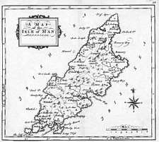
A Map of the Isle of Man
Size: 100mm x 180mm 1:310,000
Map may be by T.Hutchinson who engraved Gloucestershire + England & Wales in same series. Tooley gives no details except to note J & T Osborne who published Geographia Magnae Britanniae with 63 maps of counties of Eng + Wales, IoM is map 59 of these.
Various errors eg Swable/Snawble!
Chubb CLXXXIX; MM pXX.32.S pXX.33.S
Geographia Magnae Britanniae. Or Correct Maps of all the counties in England, Scotland and Wales, with general ones of both kingdoms and of the several adjoining Islands
S. Birt, T. Osborne, D. Browne, L. Hodges, L. Osborne, A. Miller and L Robinson 1748
(RGS (262 A 19)Geographia Magnae Britanniae...
Printed for T.Osborne, D.Browne, J.Hodges, J.Robinson, WJohnson, P.Davey and B.Law Published according to Act of Parliament October 12th 1748 [though actually issued in 1756]
(BL (Maps C 24 as 29)
|
|
||
|
|
||
|
|
||
|
Any comments, errors or omissions gratefully received
The Editor |
||