Mutlow, 1816Mutlow, 1816
|
|
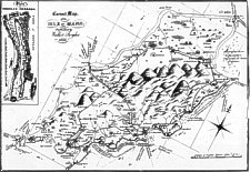
 A Correct Map of the Isle of Mann, Published May 1822 - 210 x 310 mm |
 Correct Map of the Isle of Mann. Published by Walls & Fargher 1833 |
 Correct Map of the Isle of Mann. Published by Walls & Fargher 1834 |
Based on Fannin though several names miscopied - a few additional places added (eg Castle Mona); anchorage points (ex Fannin) shown; Imprint “Mutlow Sc Russel Court “ - Tooley refers to an I. Mutlow engraver 1794/1816
History of the Isle of Man with a comparitive View of the Present State of Society and Manners;…
H.A.Bullock 1816 London: Longman, Hurst, Rees Orme & Hurst
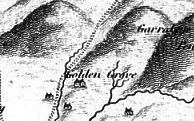
Some places identified on the map may indicate that their inclusion was based on a subscription - that of Golden Grove [now site of Injebrek reservoir] actually refers to Bullocks Map in an advertisement in the Rising Sun from 11th July 1821
FAIRY VILLA,
Amidst Superb Plantations, Romantic Scenery and Rich Perennial Crops. to be SOLD, the beautiful ESTATE of GOLDEN GROVE, (see Bullock's Map of the Isle of Man,) lying at a convenient distance from Douglas, and containing, by survey, 162 acres, ;
The House is modern and commodious, with all suitable Offices and Out-Offces, surrounded with very extensive Gardens and Pleasure Grounds, forming altogether, for a Family of Taste in easy Circumstances, a Gentlemanly Residence of no ordinary attraction.
The young Woods are the largest in the Island, covering an extent of about forty acres, and promise in a few years to return the principal Money with compound Interest. Viewing this, therefore, merely as an investment of Capital and setting aside the local beauties and extraordinary perennial Crops and Land otherwise employed, the Purchase offers no every-day advantages More Land will be added if wanted, and Part of the Purchase Money may remain secured upon the Premises.
Apply J. Wade, Esq. of Druidale, or by Letter, (post paid) to Messrs Whiteley & Mason, Solicitors, Liverpool
After this the map appears to have been acquired by George Jefferson and used in several of his publications with the title slightly altered + other additions/corrections to plate over the period - Jefferson acquired a new larger map from 1840 which was used in many guidebooks from that year.
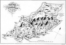
State ii - Title altered to A Correct Map of the Isle of Mann, Published May 1822.
Scale bar and compass altered, names of Point of Ayre and Calf altered to allow a smaller enclosing frame, a few corrections to names eg Mary Voar rather than Mary Far -
Imprint "T Breckell sculp.” outside frame bottom left (Mutlow's imprint ?erased as not visible on my copy - Tooley has no information on Breckell, the name would appear to be mostly found in Lancashire though the spelling Breckell is relatively rare (a Thomas Breckell was christened at St Pauls, Liverpool 1802).A Historical Sketch and Descriptive View of the Isle of Man; designed as a Companion to those who visit and make the Tour of it. By Samuel Haining Embellished with Copper-Plate Engravings
Douglas:Printed by G.Jefferson May 1822
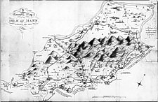
State iii: Title altered to A Correct Map of the Isle of Mann, Published by G. Jefferson 1829
various sea routes and distances added, scale bar replaced, a new names eg 'Slougaller' and various small updates/corrections eg Hamilton bridge now indicated though name present on original - Imprint Mutlow Sc Russell court now clearly visible
Used in Jefferson's Improved Manks Almanack and Tide Table ... 1832 (and possibly elsewhere) - Cubbon states first use of this map was in 1833 edition but Manx Museum has map with 1832 almanack
State iv: Title altered to A Correct Map of the Isle of Mann, May 1833
A Historical Sketch … 3rd Ed by Rev. Samuel Haining, Douglas: J.Quiggin May 1833
The Isle of Man Almanack ... 1833 published by J Quiggin
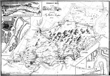
Lithographic Transfer A: Title altered to Correct Map of the Isle of Mann, Published by Walls & Fargher 1833
Inset plan of Douglas harbour added top rh - scale bar and compass altered - this would appear to be derived from State iii - Imprint Geo Smith Lithog Liverpool
Mona Diary: or Manx Almanack ... 1834
Lithographic Transfer B: Title altered to Correct Map of the Isle of Mann, Published by Walls & Fargher 1834
Plans of Douglas, Castletown and Ramsey harbours added with changes to title and scale bar - Imprint Geo Smith Lithog Liverpool
The Isle of Man Guide containing an Historical Sketch ... by Samuel Haining 3rd Edition 1835 Douglas: J. Quiggin
Mona Diary: or Manx Almanack ... 1835
|
|
||
|
|
||
|
Any comments, errors or omissions
gratefully received The
Editor |
||