 Maps
of the I.O.M - Moule, 1833.Maps
of the I.O.M - Moule, 1833.
Maps
of the I.O.M - Moule, 1833.Maps
of the I.O.M - Moule, 1833.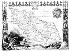
Engraved on steel which both provided for a finer line and, more importantly, longer print runs before the plate needed reworking. These maps with their highly decorative borders were issued in great numbers over some 40 years - many reproductions are published today. Originally the maps were issued uncoloured - some may have been coloured in the later editions but most colouring would appear to be recent. The Arms in top right hand are those of the Duke of Atholl and are copied from the 1826 Drinkwater/Smythe map. The sea rock behind Britannia is copied from the 'Charing Cross' illustration by Daniel King.
James Bingley, engraver, originally of Goswell Road (1823) and later Sidney Street Islington [Tooley].
Thomas Moule 1784-1851, was originally a bookseller, then worked for the Post
Office as Inspector of Blind Letters (ie those with illegible or indecipherable
addresses). He was a man of many talents publishing works on Westminster Abbey, Elizabethan
and Roman Architecture among others.
First appeared in Moule’s English Counties… Issued in parts from May 1830 - that of IoM, part XXXVIII in July 1833 (though map dated 1 June 1833) see [Camb85 The Map Collector 31 pp26 1985] - this was state 1 in which Peel and Ramsey names were omitted.
These part-issue maps were then issued together in The English Counties delineated: or A Topographical Description of England. Illustrated by a map of London, and a complete series of county maps. By Thomas Moule London: George Virtue, 26, Ivy Lane Paternoster Row 1836 with later editions in 1837,1838 - Peel and Ramsey names were added making this state 2.
In the 1839 edition of The English Counties delineated…London: George Virtue Bingley's name was erased from the map and the date altered to June 1 1839. It was also possibly issued as dissected map marked Moule’s County Maps…(that for Berkshire is known (1839)) - this is state 3.
A 4th state in which the map was redated June 1 1843 and plate no 50 added below date. These maps were then used in
Barclay’s Complete and Universal Dictionary. Part 10 (issued in 31 parts @ 1s.0d each
London:F.Sprent 1843
(F.Sprent probably related to James Sprent Virtue)A Complete and Universal English Dictionary … by the Rev. James Barclay, revised by Henry Dewhurst
London:no imprint [1843]A Complete and Universal English Dictionary … by the Rev. James Barclay, revised by Henry Dewhurst
London:George Virtue [1844]
However there would appear to be some confusion re use of different states - the publisher may have used old stock in some editions. These maps found in these and later editions are usually very tightly cropped to the decorative border as the books were slightly smaller than the English Counties delineated - often some slight loss of the border is seen
A 5th state, still dated June 1 1843 but with an added tree stump to right of date was used in
A Complete and Universal Dictionary of the English Language… by the Rev. James Barclay, A New Edition… by B.B.Woodward
London:G.Virtue [1847]Possibly issued as dissected map marked
Hall’s Pocket County Maps…Revised by W.Hughes
London A.Hall & Co. [that for Berkshire known (1848)]A Complete and Universal Dictionary of the English Language… by the Rev. James Barclay, A New Edition… by B.B.Woodward
London:G.Virtue [1851]
London:G.Virtue [1852]
London:Virtue & Co[1853]
London: James S.Virtue[1858]A Complete and Universal Dictionary of the English Language… by the Rev. James Barclay, A New Edition… by B.B.Woodward. Appendix
London:James S.Virtue[1858]
The English County maps (but not it seems the IoM) was used in an 1870 edition of the History of England.
The County Maps of Old England by Thomas Moule with Introduction by Roderick Barron London: Studio Editions 1990 (ISBN 1-85170-403-5)
|
|
||
|
|
||
|
|
||
|
Any comments, errors or omissions gratefully received
The Editor |
||