 Thomas
Kitchin, 1769Thomas
Kitchin, 1769
Thomas
Kitchin, 1769Thomas
Kitchin, 1769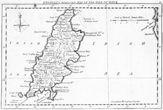
State (2) Bowles Reduced Map of the Isle of Man
Size: 121 mm x 195mm 1:375,000
N to top; Island within left hand side of map; tip of Cumberland at right hand margin. Maps similar to those of Kitchins 1764 England Illustrated but on a smaller scale. Originally used for Kitchin's Pocket Atlas of 1769 (apparently quite rare) and then with new titles Bowles Pocket Atlas
(1) No title
Kitchin's Pocket Atlas of the Counties of South Britain or England and Wales Drawn to to one scale. By which the true proportion they severally bear to each other may be easily ascertained.. Being the first set of counties ever published on this plan 1769
Printed for the Author T Kitchin Engraver Map and Printseller No 59 Holborn Hill and J Capper Map and Printseller No 56 New Bond Street.
Contains 47 plates no title or imprint but names of counties printed across page in large type. Many plates have 2 maps each with small compass indicator.
Chubb CCXXXV MM pXX.53.S
(2) Title added outside top Border: "Bowles's reduced map of.."
Bowles's Pocket Atlas of the Counties of South Britain or England and Wales. Drawn to One scale
London Printed for and sold by the prop CB No 69 St Pls Ch
A fine atlas 57 maps clearly engraved - some cases printed 2 page in that case numbers bracket at top. Carrington Bowles (1724-93) printer and publisher St Pauls Churchyard London. On 20:+21: Flintshire + IoM
Chubb CCLVI
|
|
||
|
|
||
|
|
||
|
Any comments, errors or omissions gratefully received
The Editor © F.Coakley , 2004 |
||