 Thomas
Kitchin, 1764Thomas
Kitchin, 1764
Thomas
Kitchin, 1764Thomas
Kitchin, 1764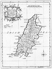
A New Map of the Isle of Man Drawn from the best Authorities: By Thos Kitchin Geogr . Engraver to H.R.H. the Duke of York.
size 180 x 240
Based on his earlier map of 1754.
Map 53 [in appendix to 2nd vol - atlas contained 54 maps] from
England Illustrated or A Compendium of the Natural History Geography Topography
and Antiquities Ecclesiastical and Civil of England and Wales .. In Two
vols
Printed for R and J Dodsley in Pall-mall MDCCLXIV 1764
(work was first published 1 Dec 1763 but acording to Kingsley no copy bearing
that date has been found - it is possible that first issue was published with
date 1764 on title-page
Kitchen’s English Atlas: or, a compleat set of maps of all the counties
of England and Wales…The whole engraved…from drawings after actual
surveys and other best authorities. By Thomas Kitchen, geographer to His Royal
Highness the Duke of York
London: J.Dodsley [1765] {BL (Maps C 25 a 2)}
|
|
||
|
|
||
|
|
||
|
Any comments, errors or omissions gratefully received
The Editor |
||