 Thomas
Kitchin, 1749Thomas
Kitchin, 1749
Thomas
Kitchin, 1749Thomas
Kitchin, 1749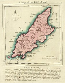
Thomas Jefferys, (fl 1732-1771), was a prolific engraver and map publisher.
Thomas Kitchin (1718-1784) was one of the most prolific English engravers and map publishers of his time.
The atlases contain 49 maps; at bottom of each plate outside border lines,are notes showning Fairs etc. All plates plain at back
Below map is descriptive text:
The Isle of Man containing 17 Parishes, 5 Towns and 2 Castles is a distinct
Bishoprick and Principality held by the Earl of Derby of ye Crown of Engld
the Bishop is etil’d Bishop of Sodor & Man is confirm’d by the King & conse-
crated by the Archbp. of York he is no Ld of Parliamt because he is nomina-
ted by the Ld of the Isle who is a Subject. There is a Hill here remarkable
for yielding a Prospect of England,Scotland & Irland.______________
Post 1765 (as ilustrated above) this text was amended to to cover the recent Act of Revestment (1765)
The Isle of Man containing 17 Parishes, 5 Towns and 2 Castles has a Bishoprick in the province of York.
and the soveregnity has lately been annexed to the Crown of England for 70000L.
paid the Duke of Athol but he retains the Patronage and is Lord of the Manors. In it
are several Pretty towns viz Ramsey, Laxey ,Peel, Castletown, Balley Salley, Douglas.
It has several good harbours and a great plenty of Fresh Water that might be
expected in a Spot of its size surrounded by the sea. They have large Foreign
Trade but no manufacture. It is about 30 miles long by 10 broad & next to it is a small Isle
called the Calf of Man 1/2 mile out the sea where vast numbers of wild fowl build their nests and it abounds with rabbits
The title ‘Sodor & Man’ obviously confused Kitchen who labelled Castletown as “Sodor or Castletown” which error is found in other Kitchen maps.
Possibly in
The Small English Atlas…Part ? (Issued in parts)
London M.Payne (and eight others).
According to Kingsley no copy of this atlas, advertised as being published at
approx. weekly intervals from Nov 1748 has been found and it is likely that
Kitchin and Jefferies took over the work at an early stage possibly even before
publication.
The Small English Atlas being a New and Accurate Sett of Maps of all the
Counties in England and Wales
London, Publish'd according to Act of Parliament by Messrs Kitchin and Jefferys
1749 and Sold by M Payne at the White Hart and MCooper at the Globe in Paternoster
Row
{BL (Maps C 24 aa 6)} {RGS (10 B 2)}
The Small English Atlas
London Kitchen & Jefferys 1751 {Whit W58}
The Small English Atlas…
London Robert Sayer and John Barnett, John Bowles and Carington Bowles (1775)
{RGS (10 B 4)}
An English Atlas or Concise View of England And Wales
London: Robert Sayer and Jn Bennett 1776
The Small English Atlas…
London Robert Sayer (1785)
An English Atlas…
London Robert Sayer 1787 (reissued 1794 and 1796)
{BL (Maps C 25 a 3)}
|
|
||
|
|
||
|
|
||
|
Any comments, errors or omissions gratefully received
The Editor |
||