 Pascaart vant Canaal Tusschen Engelandt en
Vrancryck, alsmede geheel Ierlant en Schotland ... - 1650Pascaart vant Canaal Tusschen Engelandt en
Vrancryck, alsmede geheel Ierlant en Schotland ... - 1650
Pascaart vant Canaal Tusschen Engelandt en
Vrancryck, alsmede geheel Ierlant en Schotland ... - 1650Pascaart vant Canaal Tusschen Engelandt en
Vrancryck, alsmede geheel Ierlant en Schotland ... - 1650![Anthony Jacobsz[oon] - 1644](zjan1650.jpg)
W to top;Shows whole West Coast England & Wales and Ireland
East Coast partially obscured by large cartouche and title
Title flanked by Neptune & nereid (Shirley describes as ancient British man and woman), dolphins and royal arms above.
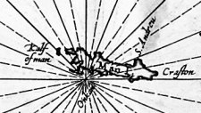
Detail showing IoM
The Island is based on Speed but elongated with only four place names (chosen I suspect for ease of placement rather than importance - Kalf of Man, St Andreu, Craston, Onchan
It appeared aspart of a collection of sea charts in Volume Five of Jan Jansson's Atlas Novus - the title of the Atlas reflecting the language (Latin, Dutch, French or German text on reverse tho some copies are blank on reverse) - later editions in 1652, a 2nd state of map, in which the seas are named, is found in 1657 & 1659 editions
Shirley #545
Koeman Jac.14
|
|
||
|
|
||
|
Any comments, errors or omissions
gratefully received The
Editor |
||