 Hall, 1832Hall, 1832
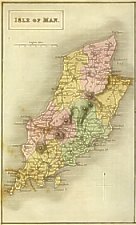
Isle of Man.
Size: 215mm x 130mm 1:300,000
Sidney Hall (fl 1817-60) engraver and publisher 14 Bury St Bloomsbury and 18 Strand London.
Isle of Man on same sheet with Guernsey,Jersey - however IoM map often seen cut from others - had long life and used in
many guide books
Like the near contempory map by Lewis based on Smythe
Chubb CCCCXLVI
1: Size: 215mm x 130mm
Isle of Man.
(with Guernsey,Jersey )
N to top
Aa:Title within double lined box
Ab:scale
Ee:compass
Major hills indicated by circles within hachuring
"Kirk Sheading" used for K.Micheal Sh.
? Ce(os):Imprint "London Published by Chapman & Hall, Arundel Str Strand "
Chubb CCCCXLVI
Reissued in:
A New British Atlas 1833,1834 and 1836
A Travelling Atlas 1842,1843,1846,1848 and 1860
A New County Atlas 1847
A Travelling County Atlas 1842,1843,1845, 1846, 1847, 1848
A New County Atlas 1847
A Topographical Dictionary of Great Britain and Ireland, compiled from local information, and the most recent and
official authorities. By John Gorton ... with fifty-two quarto Maps, drawn and engraved by Sidney Hall. London: Chapman
and Hall, 186, Strand, 1831 [IoM map bound in vol 2 under Jersey]
A Topographical Dictionary. .. with fifty four quarto maps... London: Chapman and Hall, 186, Strand, 1833 [the maps have
imprint Chapman and Hall, 186, Strand, 1832]
2: Size: 215mm x 130mm
Isle of Man.
(with Guernsey,Jersey )
Ce(os):Imprint "London Published by Chapman & Hall, 186, Strand "
Chubb CCCCXLVI
3: Size: 215mm x 130mm
Isle of Man
(with Guernsey,Jersey )
Map 24: IoM, Guernsey, Jersey 1832
Chubb CCCCXLVI
A Travelling County Atlas. with all the Coach and Rail Roads accurately laid down and coloured, and carefully
corrected to the present time.
Engraved by Sidney Hall
London: Chapman and Hall, Strand, 1842
Another ed 1843,1845,1846,1848,
All kept same title and size - railaways added and imprints altered to reflect publisher
A: Isle of Man Size: 185mm x 135mm (with Guernsey, Jersey)
Map 21 IoM, Guernsey,Jersey
Chubb CCCCXCVII
A Travelling Atlas of the English Counties. By Sidney Hall... London: Chapman
and Hall 193 Picadilly"
B: Another edition 1873. railways updated, plate numbers placed outside border instead of between as earlier
C: Another ed 1880. imprint corrected to London Chapman and Hall Limited
Isle of Man Guide: .. Fifth Thousand Douglas: William Dillon 1841
|
|
||
|
|
||
|
|
||
|
Any comments, errors or omissions gratefully received
The Editor |
||