 Upcott
Gill , 1885Upcott
Gill , 1885
Upcott
Gill , 1885Upcott
Gill , 1885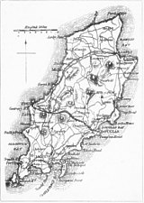
96 x 136 mm
Appeared on page 298 - apart from a sequence of much smaller scale sketch maps of the English and Welsh coasts it is the only other map in the book. Shows the 1873 railway lines to Peel and Port Erin - also a proposed, though never built, line to Laxey (the somewhat later Electric Railway to Laxey and Ramsey took a somewhat different route) - also shows a line to Rhenass Falls which again was never built though such a proposed route through to Kirk Michael did appear on maps c. 1870..
The outline of the Island follows the incorrect pre O/S maps of the 1840's and '50's - there are also a sequence of numbers on the map which would indicate its use elsewhere. There were better maps of similar scale that could have been used (eg c. 1875 Railway Map)
Title "Isle of Man" appeared outside enclosing box - no engraver's name or source given.
Seaside Watering Places ... Fifth Edition..London: L. Upcott Gill, 170 Strand, W.C. 1885
|
|
||
|
|
||
|
|
||
|
Any comments, errors or omissions gratefully received
The Editor |
||