 Fannin's Map of the Isle of Man - 1789Fannin's Map of the Isle of Man - 1789
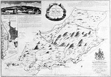
A Correct Plan of the Isle of Man
Size: 510mm x 720mm
Peter Fannin, a Naval officer, erstwhile Master of the 'Adventure' one of the ships that accompanied Capt. Cook on his first expedition, retired (possibly on half pay) to Douglas where he set up a school and taught navigation. One pupil, c.1774-6, was John Gell who later became the curate at St Marks. He left the Island around the start of 1794, presumeably because of the Anglo-French war, as he places a notice in the Manx Advertiser asking that anyone to whom he is indebted should send notice to Mrs Fannin before 1 March 1794. Mrs Fannin would appear to have stayed on the Island for in Manx Advertiser 31 Jan 1795 an Ann Looney (Confectioner from London) announces that she has lately opened shop at Mrs Fannin's where the late Mr Booth formerly lived near the New Church [St George's].
He published his ' Correct Plan of the Isle of Man' , engraved by H. Ashby, in Jan 1789 from whence it formed the basis of most maps of the Island for the next forty years. The island shape with its over square Jurby Point is considerably less accurate than the maritime survey of Mackenzie of 1775. However his representation of the hill masses of the Island was a major improvement on earlier maps. He also gave an indication for the first time of the roads on the Island as well as the first town plan of Douglas.
It would appear to be based on personal observation and survey; he includes brief descriptions of the various bays and harbours as anchorage points. Although the island shape possibly owes something to Mackenzie, the soundings and anchorage points differ from both Mackenzie and Collins. He also quotes the height of Snaefell as "580 yards above the sea".
The plate from which the map was taken is still in existance and is owned by the Admiralty - a copy was taken some years ago and used as the master from which 7/8 scale copies may still be bought.
Title "A Correct Plan of the Isle of Man" - published Jan 1789
Engvd by H. Ashby (1744-1815) engraver London.
Gives Latitude of Douglas by ‘Lunar Observation’ -
technique developed by Johann Tobias Meyer (1723-67) and lunar Tables
published in "British Marine C" 1763 by Nevil Maskelyne
(1732-1811).
Included as insets are the first printed map of Douglas and a view of the South Quay.
|
|
||
|
|
||
|
Any comments, errors or omissions
gratefully received The
Editor |
||