 Joseph Ellis, 1766Joseph Ellis, 1766
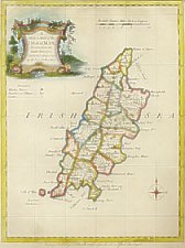
13: A Modern Map of the Isle of Man
Size: 290mm x 230mm 1:280,000
Joseph Ellis, engraver in Clerkenwell, worked between 1750-1800; Hodson records name as Joseph on basis of advertisement by Bowles and Carver in 1795 - most other authorities (inc Tooley) have John.
Atlas is basically unoriginal but appears to have been very popular consisting of a set of clearly engraved maps v similar to those by T Kitchin in England Illustrated of 1764. Titles are "A Modern Map of .." and imprint "Printed for Robt Sayer in Fleet Street and Carington Bowles in St Pauls Church Yard" (sometimes rvsrd)
Chubb CCXXVII ; MM pXX.49.S
The New English Atlas...
London R. Sayer and Carington Bowles 1765
(BL (Maps C 24 as 2))
Ellis's English Atlas: Or a Compleat Chorography of England and
Wales: in fifty Maps containing more Particulars than any other Collection of
the same kind The Whole calculated for the use of travellers, Academies and
of all those who desire to improve in the knowledge of their Country From the
latest surveys of the several Counties
Engraved by and under the direction of J Ellis London Printed for Robert Sayer
at the Golden Buck near Serjeants Inn in Fleet Street and Carrington Bowles
next the chapter house in St Pauls Church yard Price 10s 6d in Red Leather or
the Pocket MDCCLXVI
London: Robert Sayer and Carington Bowles and Robert Sayer 1776
(BL (Maps C 18 a 20)) (RGS (8 B 7))
Ellis's English Atlas:... in Fifty maps...
London: Carington Bowles and Robert Sayer. 1776
|
|
||
|
|
||
|
|
||
|
Any comments, errors or omissions gratefully received
The Editor |
||