 Collin's
Maritime Survey of the Isle of ManCollin's
Maritime Survey of the Isle of Man
Collin's
Maritime Survey of the Isle of ManCollin's
Maritime Survey of the Isle of ManFollowing much criticism of Seller’s marine atlas it was realised by many that a new survey of the English coast was needed. Trinity House, the Admiralty (who provided a suitable vessel and crew) and the Crown (who paid nearly £2000) were involved. Captain Greenvile Collins an experienced naval officier who had sailed with Sir John Narborough to the South Seas in 1669/71 was chosen. The Admiralty Order dated 23 June 1681 The King had chosen Captain Collins,Commander of the Merlin Yacht, to make a survey of the sea coast of the Kingdom by measuring all the sea coast with a chain and taking all the bearings of the headlands with their exact latitude . Progress was slow as Collins was only paid after the survey was complete. Collins arranged for the printing chosing a relatively unknown Richard Mount as agent. This was the first complete Pilot book in English of the coasts of Great Britain and although it received much criticism for its alleged inaccuracy it continued on sale for over a century by the family firm founded by Mount. see C.Verner (MCS 58) and Robinson (1962)pp40/43 for details.
From a maritime survey made in Summer 1687 "1687 Surveyed Liverpool, the Isle of Man, Carrackfergus, Dublin, Kinsale and Cork which is all that is surveyed, and is the most useful and necessary part to Navigation" Pilot 1753 ed p24 Collins used land surveys to help him draw the coastline which possibly explains the added parish boundaries etc for the IoM. (original MS chart Hydrographic Dept B893) Engraved by H.Moll who was probably responsible for cartouche as MS charts have none. According to Vernier no copies of charts issued as separate issues have been identified. First ed of Pilot was ready for sale in Feb 1693 (new style); Dutch privilege issued 1682. Letterpress by Freeman Collins (possibly some relative?)
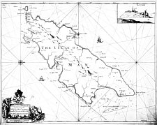
[The Isle of Man]
Formed sheet 31: [The Isle of Man ]
To the Rt Honorable WILLIAM, ELE, OF DERBY Lord of ye ISLE of MAN & This Map is humbly Dedicated and Presented by Capt.
G. COLLINS.
Great Britain's Coasting Pilot. The First Part Being a New and
Exact Survey of the Sea-Coast of England from the River of Thames to
the Westward with the Isles of Scilly, And from thence to Carlile.
Describing All the Harbours, Rivers Bays, Roads, Rocks, Sands, Buoys,
Beacons, Sea-marks, Depths of Water, Latitude, Bearings and Distances
from Place to Place, the Setting and Flowing of Tydes, with
Directions for the knowing of any place and how to Harbour a Ship in
the same with safety. With Directions for coming into the Channel
between England and France by Captain Greenville Collins hydrographer
in Ordinary to the King and Queens most Excellent Majesties.
London: Printed by Freeman Collins and to be sold by Richard Mount
Bookseller at the Postern on Tower Hill 1693
Great Britain’s Coasting Pilot. The Second Part"River of
Thames Northwards with the Illands of Orkney and Shetland Describing
...
The two parts are always bound together
Great Britain's Coasting Pilot
London:T.Page,William & Fisher Mount 1723 {BL Maps 31 e 7)
Great Britain's Coasting Pilot
London:W.Mount & T.Page 1736{LC P 7996},1738 {BL Maps 13 e
11},1744 {AL Va 39},1745 {NMM COL 002}, 1749 {LC 7997}
Great Britain's Coasting Pilot
London:W. & J.Mount & T.Page1753 {RGS 14 B 86}
(reduced facsimile published 1965 the Sudbrook Press & George G.
Harrap & Co)
Great Britain's Coasting Pilot
London:W. & J.Mount & T.Page and Son1756 {BL Maps 13 f
22}
Great Britain's Coasting Pilot
London:W. & J.Mount & T.Page and Son1760 (coloured ed) {RGS
14 B 86},1761?,1763 {MarM Rotterdam},1764?,1767 {NMM COL 004},1771
{LC 4005}
1774 Plate recut & Restippled - lefthand hill & foliage overhanging rh rock erased in cartouche; no change to map
Great Britain's Coasting Pilot
London: J.Mount & T.Page 1774 {Hy Dpt},1785(name of Greenvile mis-spelled){RGS}
Great Britain's Coasting Pilot
London:.Mount & Davidson 1792 {NMM}
+ late french issue without embellishments
|
|
||
|
|
||
|
Any comments, errors or omissions
gratefully received The
Editor |
||