 John Bartholomew
1892.John Bartholomew
1892.
John Bartholomew
1892.John Bartholomew
1892.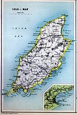
Title Isle of Man Dimensions (within inner border) 166 x 110 mm Based on O/S
Isle of Man above Douglas Harbour (1.8"x4.3"), same sheet as Scilly Is (both maps enclosed within an outer border
with divider) when found in Atlases but IoM map can be used on own (some text outside inner border)
A series of county maps and plans with descriptive index and statistical notes. Edited by John Bartholomew, FRGS &c
Engraved plates used for litho transfer thus may find at different representative fractions
Series (not Man) originally issued 1872
Smith states some plates used in 9th Encyclopaedia Britannica - not Manx which used small scale map inset within text
Printed in
Black's handy atlas of England & Wales. A series of County maps and plans with descriptive index and statistical notes
edited by John Bartholomew, F.R.G.S. &c.
London,Adam and Charles Black - various dates (usually page 32)
1898,1899 also in Black's guides
Smith V(3)
|
|
||
|
|
||
|
|
||
|
Any comments, errors or omissions gratefully received
The Editor © F.Coakley , 2008 |
||