 John Bartholomew
1880.John Bartholomew
1880.
John Bartholomew
1880.John Bartholomew
1880.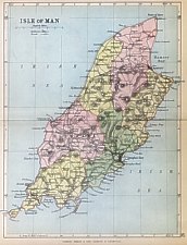
Title Isle of Man Dimensions 200 x 145 mm Based on O/S
Outer border gives Latitude + longtitude; Sheadings coloured but Parish boundaries not indicated
Produced for Philip’s Handy Atlas IoM map added 1880 edition (Smith states 1881)
many editions (approx at 2 yr intervals until early 20th century) - the railways were updated and can provide an approximate
date.
Philips’ handy atlas of the counties of England: by John Bartholomew, F.R.G.S. New and enlarged edition with
consulting index
London and Liverpool, George Philip and Son 1880
Philip’s handy atlas of the counties of England…New and enlarged edition shewing every railway station in
England and Wales
London and Liverpool, George Philip and Son 1895 ...
Editions:
A: 1880: with IoMR + MNR p42
B: 1882(late ed): with projected Douglas to Laxey Railway (dashed) p42
F: 1893: Rlys Douglas to Ramsey (dashed) + Foxdale to Ballasalla
G: MER to Laxey (solid line); Foxdale + projected Foxdale to Balasalla p42
H: 1898: + Snaefell Rly (but not Laxey to Ramsey)
I: 1900+: with Laxey to Ramsey added
J: 1900+: All rlys (inc projected Foxdale-Ballasalla); coloured contoured at 500ft intervals Mountain Road added + other
minor changes to roads (eg around Bride) + some additional names; Conchan instead of Onchan
K: Title : Geological Map of Isle of Man - overprinted with geological info possibly from Drift Ed (1898) though rather simplified
Smith XLIV
|
|
||
|
|
||
|
|
||
|
Any comments, errors or omissions gratefully received
The Editor © F.Coakley , 2008 |
||