[from Proc IoMNH&ASoc vol 4 #3 1939]
January 13th, 1939.
By J. R. BRUCE, M.Sc., Rev. J. DUFFIELD. and P. CAIN. At the monthly meeting held at the Museum on 13th January, 1939, various interesting matters on the Parish of Rushen -were discussed by Mr. Bruce, the late Vicar, and Mr Philip Cain '{Port Erin).
Mr Bruce read the following paper on
Four examples of defensive earthworks have been recognised in the Parish of Rushen:
1. Cronk Howe Mooar, a small hillock of late glacial goodgravel, at some time adapted to defensive purposes;
2. A promontory fort, i.e., a defended headland, on the rocky spur of Burroo Nedd, which juts out into the Calf Sound, in the extreme S.W. corner of the Island;
3. Another promontory fort, jutting into Perwick Bay, about 2½ miles eastwards round the coast from Burroo Nedd;
4. A small "ring-work," now almost obliterated, about threequarters of a mile from Ballakilpheric, on the easterly slope of the Carnanes.
-"Cronk Mooar" of the Ordnance Survey and "Fairy Hill" of the Guide-books-is one of the most conspicuous of our earthworks, rising sharply from flat swampy ground near the Parish Church. The site was excavated by the 'late P. M. C. Kermode and the late Professor Herdman in 1912, and an illustrated account of their work was published in "Manks Antiquities" (2nd Edition) under their joint authorship in 1914. They reached the conclusion, already indicated, that the greater part of the mound is of purely natural origin, being in fact an "esker" or flood-deposit, dating from the close of the Quaternary Ice Age. At some time, certainly after the introduction of iron, and presumably in Viking times, when similar mounds are known to have been in use, the hillock was adapted to the purposes of a small fort by the construction upon and within its summit of a small stone-revetted oblong enclosure, 18ft. x loft., and by digging a moat, still some 20ft. across, around its base.
-The earthworks upon Burrow Nedd have been visited and examined on numerous occasions by the members of this Society on their field excursions. The site, apart from its archaeological interest, is one of great natural beauty, embodying and adjacent to some of the finest coastal cliff scenery in Britain. There appears, however, to have been no systematic examination of the remains, and no plan other than that of the Ordnance Survey is published.
A typical promontory fort, the site owes its defensive features partly to the precipitous cliff with which it is surrounded on three sides, and partly to a double earthern rampart crossing the neck of the promontory on the landward side. Access to the enclosure was by way of a narrow track between the westerly extremity of the ramparts and the brink of a 50ft. cliff which drops sheer to the beach. Within the enclosure are numerous hutfoundations, both circular and rectangular, testifying to at least some period of continuous occupation. Several groups of cupmarkings are to be seen on prominent rocky knolls within the enclosure.
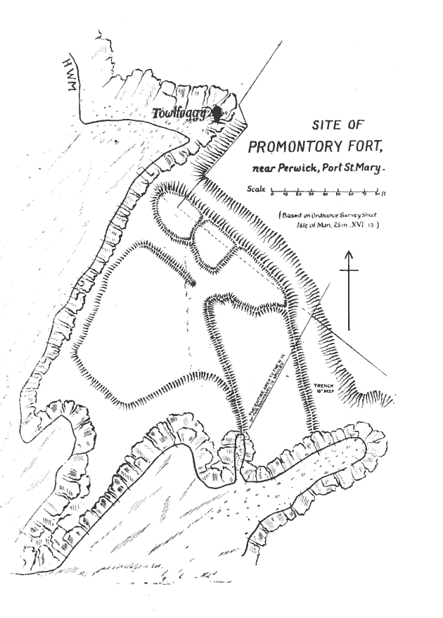
.-While Cronk-Hlowe-Mooar has been carefully examined and described, and Burroo-Nedd still remains intact for the future investigator, it is a matter for profound regret that the fine defensive earthwork now under consideration is almost wholly obliterated, and practically the whole of our knowledge of the site is derived from the plan embodied in the Ordnance Survey of 1868. Within 30 years of that date, the enclosure and levelling of the ground and the construction of a large house and garden terraces destroyed practically every trace of the original fortifications, with the exception of the southern termination of the great trench which separates the promontory from the `mainland'. A plan of the site (Fig. 1) is based upon the 25in. Ordnance Sheet, XVI. 13, amplified by a few details which can be filled in from presentday inspection of the area.
The site is a rocky headland, falling steeply in cliffs to the beach on all but its north-eastern side. Here the main artificial defensive work lies, and consists of a trench cut in part through the drift and sub-soil overlying the rock, and in part through the rock itself. The trench is over 220ft. in length, and terminates at either end on the very brink of a 50ft. precipice. The remaining portion of the trench, 30ft. wide, and still loft. deep after many centuries of silting-up, affords an impressive indication of the original character of the work. Within the restricted area bounded by cliff and trench, an area of about 200 feet in either direction, several structures were to be seen at the time of the Survey. An embankment lined the seaward side of the trench-this consisted, of course, of the materials dug out when the trench was made, but so placed as to heighten and render more effective the counterscarp of the cutting.
Access to the enclosure was gained by a narrow track along the edge of the cliff on its N.W. side. The inner end of this approach-way passed between re-entrant embankments, while on one side of the entrance a circular foundation suggests the existence of a guard-house. The whole structure is clearly the work of a people well-versed in the art of construction, and suggests the elaborately-designed approaches of some of the hill-forts in North Wales, where excavation in recent years has placed the date of such works in the late Celtic Iron Age, and shown that they were occupied, perhaps discontinuously, throughout the period of the Roman occupation.
Within the enceinte there are traces of other structures, including a secondary embanked enclosure abutting upon the main trench - this may have been surrounded by a palisade. The rest of the area, seawards of this point, appears to have been raised to an artificial level.
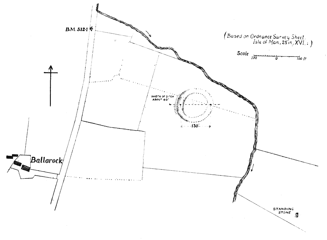
-On flat land at about 500 feet level, at the bottom of the eastern slope of the Carnanes, there are the remains of a small circular ring-work. The outlines have been largely obliterated by centuries of ploughing and natural silting, but a crescentic trench, now little more than a foot in depth, can still clearly be seen in the grassland. This doubtless formed part of a circular work, the original diameter of which, from centre to centre of trench, may be estimated at about 130 feet. Measurements taken in 1938 are embodied in the plan (Fig. 2). The present width of the trench is about 40 feet, but this width is largely the result of erosion, and when newly-dug and steep-sided it may have been less than 20 feet across. A barely perceptible trace of embankment remains on the outer edge of the ditch at one point. This is unusual, and should not be taken too seriously until excavation has shown its ancient character. A rivulet lies within 100 feet of the enclosure on its N. and E. sides, so that the trench could readily be flooded if additional protection were needed.
It is difficult, if not impossible, to assign any "defensive" purpose to so slight a structure, situated in so indefensible a position. Such enclosures are numerous in Ireland, where it has been suggested that they are cattle-pounds, intended for the impounding of cattle in time of a threatened raid, or. as some think, against the depredations of wolves, which were numerous. in prehistoric Ireland. Here in Mann, we may rule out the lupine enemy, and we are left with the view that this and like worksa ditch and hurdle-fence surrounding a small enclosure - were pounds where the herdsmen could hastily fold their cattle when they were called from the shielings to drive off a Viking or Irish raid.
REV. J. DUFFIELD, M.A.
Rev. J. Duffield brough with him one of the Parish of Rushen Registers, extracts from which were alternately sad and tragic and quaint and amusing. They lost none of their humour at the hands of our interesting Irish leader.
The following notes of Mr Duffield's address are supplied: Although there must have been a parish church on the site of the present one at Kirk Christ. Rusher, the existing registers do not go further back than the year 1708, but even so they provide much interesting matter for those w'ho are prepared to do a little patient searching.
My own special interest was awakened by finding on the second page of the register, after a page of Baptism entries, the following curious note:
"A Remedy for stagnation of the blood.-Infuse an ounce of Salt-peter into a quart of spring water, and when dissolved, take half-a-pint thereof at going to bed and halfa-pint in the morning, fasting for two days. Let the water be made luke-warm, and repeat the same at some intervals as may be required."
Following the medicinal suggestion came another prescription, this time for making ink:
'To make black ink.-Bruise a pound of galls, boil them in about five quarts of beer, then add a quarter-of-apound of Roman vitriol and copperas mix'd and warm the ink again, adding a little rock allum. When it is cold strain it and add twelve ounces of gum-arabic. Stir it often and keep for use."
Perhaps it was thought wasteful to use so much beer all at once for the mere purpose of ink-making, for immediately under the above entry come the words: "To make the fourth part of the above," and the prescription follows with the suitable reduction to a "quart and a half-pint of beer" etc.
Of course the great mass of entries are the bare facts of Christening, Marriage, and Burial, but occasional comments accompany the entries. Here are a few from the Burial register
1718.-John Christian. An Irishman. How did an Irishman come to possess the name "Christian"?
1719.-George Mercer. A Miner. Were the Rushen Leadmines going strong in those days, or was George Mercer, with his so English name, one of the first "come-overs" to settle in Port Erin or Port St. Mary?
1720.-William Christian. Sumner. Alas the Sumner is no longer an Island official. There are several entries in the earlier 19th Century Churchwardens' accounts of payments to the Sumner in respect of his parochial duties. The Coroner now "summons" the Vicar and Wardens to attend the Chapter Courts.
1723.-John Boyd, of Belfast. This interested me very much, because Boyd is to-day a characteristic Belfast name, and also because the Vicar in making his notes in the register distinguishes between an "Irishman" and a "Belfastman."
1724.-William Crebbin. A Soldier. Here is an authentic Rushen name, common enough in Port St. Mary at present. My imagination pictures William Crebbin following the drum. fighting at Ramillies Oudenarde and Malplaquet, one of Marlborough's men, and coming home with strange stories of foreign parts.
But the entry which intrigues me most was this:1731.-William Watterson. A countryman. What does this mean? There were dozens and dozens of Wattersons in Rushen. then, as there are to-day. Why was this William described as a "Countryman"?
Names and place-names have changed very little with the passing years. I used to wonder why Archdeacon Kewley always spoke of " Kentraugh " (the home of the Gawne family) as if it were spelt " Kentracht," but when I found in the year 1729 a burial entry from " Kentraight " I understood. Many of you know Evan Qualtrough, who has been for so long Parish Clerk of Rusher. I note that in the year 1799 the funeral is recorded of "Evan Qualtrough, Parish Clerk."
Until relatively recent times the care of the poor of the parish devolved upon the Vicar and Wardens, so naturally there are many entries which refer to poor relief, but I have noted one or two somewhat unusual ones.
June, 1763.-Collected for Richard Roche, a poor cripple from Limerick, Ireland, by the Vicar's recommendation (unfortunately I cannot decipher the amount they thought an Irish cripple was worth).
November 30th of the same year.-Collected for Danl. Connel, John Cowin, Gilbert Korsley, Thos. Cain, in Ballabeg, Kk, Braddan, who had their haggard, their houses,, and their goods consumed by fire, the sum of Ł1 17s. 0d. Was this a case of an all-Island appeal?
A Weather Note. I was anxious to find out if the worldshaking event, the Battle of Waterloo, had any mention in the registers, but I searched 1815 in vain. However, at the end of 1816 comes the following striking note:
"Here ends the year of the Christian era 1816, a year remarkable in the annals of time. From the month of March to the month of November rains have been singularly frequent, for the space of eight months the number of dry or fair days have been very small in comparison-the earlier part of the harvest in this island commences in the latter end of September, and a part of the corn was not cut until the end of October, when there came a fall of snow accompanied by .frost, to which succeeded in November and December a continuance of very high winds accompanied with rain in torrents. The crops of wheat have universally failed, being damaged in the ear--and cannot be made into loaf. An uncommon scarcity marks this year, which will be thus handed down to posterity."
In the parish of Rushen, bounded on three sides by the sea,. it is natural to find in the registers many references to the bitter cost of the living earned from "the herrings." Look at this note, dated July 19th, 1763:
" William Watterson, of Ballafesson, Robert Christian,. tenant of Ballagawne, John Waterson, of Saureby, Patrick Crebbin and William Kneen, all of this parish, and John Kneal, of Ballasalley, being all one boat's crew, went to the herring fishing along with the rest of ire fleet. But the evening appearing dark and lowering, and heavy rain continuing, the most part of the fleet returned to harbour before night, the wind being then about S.E., and pretty calm. About ten o'clock at night the wind leapt up suddenly to about North and blew so tempestuously that the boats that stayed at sea till then were hard set to save theirlives; but the said persons were never more heard of, being, supposed to have perished near the Carrick or Chickens of the Calf."
In November, 1789, there was an accident in Port Erin Bay. Parson John Clague, then vicar, tells the story thus: "James Cottier, son of Thomas Cottier, the Rowany, being a shopkeeper in Port-iron, was shooting a long line in Port-iron Bay three weeks ago last Tuesday, along with two young men in a punt, and it being a blowing day, upon their return in the surf, near the shore, they were all three washed out of the punt, and Cottier, being a good swimmer, carried on his back one of the young men over to a buoy, and afterwards endeavoured to save himself. In the meantime a boat which was at sea came to their assistance, but unluckily one of their men fell overboard, and whilst they were busily recovering this man Cottier was drowned. A caution this to all not to be too venturesome at. sea."
January 13th, 1939.
We have pleasure in publishing Mr Philip Cain's notes of his address to the Society on the 13th January, 1939. Mr Caine's treatment of the subject and his historic and linguistic observations are unconventional.
We have been told that in the Parish of Rushen there was a harbour called Purtt Chiarn, "Lord's Harbour," so called because of its being used by the Lord of the Island, who required, for his fleet of large rowing-boats, a good firm beach. where his boats could easily be drawn to safety.
Owing to Manx words not being properly pronounced, this became Purt Yiarn, " Iron Harbour," then Port Iron.
From the old custom of attending religious service, called "Mass" before going to sea, came the name Purt Erin, " The Mass Harbour."
Near the harbour is Balla Furt, " Harbour Town." Here the Lord, with a Jury, held Courts, their decisions after being promulgated on Slieau-Quailyn, " The Meeting Mountain," near St. John's, became law. Also in Balla Furt, at a place called Cronk Geinniagh, " Sandy Hill," stood an old Keeill called Keeill Catherina. "Catherine's Church," which was rebuilt and enlarged' by a gentleman whose name was Milner. It was then called Cavval-y-Wyllar, " Milner's Chapel."
About the middle of the last century a Methodist Chapel was built there. In the year 1860 it was rebuilt, being the fourth place of worship on the same site, which is now called Dandy Hill.
On the North side of Port Erin Bay, between the bath and Bradda Head, is Gaue-Ree-Pherick, " King Patrick's Cove," now called Bradda Glen.
In the beginning of the 18th Century, farming and fishing were the chief industries.
At fairs, where private sales were conducted, a large cross of wood was erected to remind people of the suffering caused by unjust dealing. When a bargain was agreed on, if the goods were a number of small articles such as eggs or potatoes, the seller usually included a few more than the buyer paid for; this was called dooraght, " getting."
If the goods sold were large articles, the seller, on receiving the money, usually gave a small sum back to the buyer; this was called ping-vrishee, " luckpenny." These were not considered part of the bargain, but tightening the bond of friendship between the buyer and seller.
The farmers grew Lent, "Flax," which was dressed and spun into thread by the women, then twisted by the men into fishing lines called handlines and bales, " box " or " basket lines." The part of the line to which the Dhoohan, "darkness" or " deception " now called fish-hook, was fixed, was made of horse hair and called darag; at the point where the darag was fixed to the back was a small piece of line twisted. into which the point of the hook was fixed when not in use. This fixing of the hook was called " kewdaa. " putting out of action."
The bait was called brega. " untruth." The place where the darags were made is near Balla Furtt and is still called the Darrag.
Where Balla Furt and Edremony joined on the shore was -the Ooig Mooar, "Big Den," referred to in old deeds as the big cellar. Thought by old people to be a smugglers' cave.
Also from Cronk Breckan, " Speckled Hill," part of an old underground arch roof was recently removed; it bore clear testimony to the work of smugglers. The hill is part of the lower Rouany, " rioting." It is adjoining the site of the Falcon's `Nest Hotel.
Cronk Creim er, " The hold-on Hill," is situated on the upper Rouany. These names suggest that this was once the site of several serious struggles.
When herring fishing started a large number of people were employed. They had first to grow and dress the flax, spin the twine and then make the net. The net was 100 yards long and 16 yards wide, the distance between the knots being one inch. About twelve of these nets joined together formed a boat's train, and cost about Ł100.
On one occasion a shoal of govag, or gobbag, " small mouth,"now called dogfish, visited Port Erin Bay and did great damage to the herring nets. Since that time it is part of the duty of the Vicar of Rushen to meet the fishermen every evening on Port Erin shore and pray that the nets be protected from the ravages of the govag.
A portion of the fish caught by each boat was claimed by Customs Officers for the Revenue. The fish tax, it was thought, was very much resented by the fishermen. They landed the tax on or near a rock which they called Creg-y-Fulctureagh,
" Dishonesty Rock." There, too, smugglers are supposed to have landed large quantities of contraband goods. Possibly for this reason the Canal Trie, "Beach Watchers' Huc," was erected near this place. It was at the top of a little beach now called Canal Trie. (? Cabbane Traih).
On the South side of Fleshwick Bay is a rock where large quantities of fish were caught by rod and line, the owner claiming a tithe of all fish caught there. The rock is called Creg-y-Jaghee, " Tithe Rock." It is still known by the name, but the tithe is not collected.
On all the hill tops of Rushen there are traces of watchtowers where a watch was kept for raiders who plundered the Island. The watchers signalled to each other by torches or the blowing of horns.
The chief tower was near Cregneish, on Cronk Meill, " Liphill," so called because from this tower a man was sent to deliver the message with his lips to the Captain of the Parish, who, to gather up the men to meet the raiders, sent over the parish a man on horseback bearing the Captain's Staff of Office, known as the "fiery cross." The word of the bearer of the cross was obeyed without hesitation. The cross was made of wood, two feet long, and one foot wide, painted red. The bottom end was slightly burned.
The last time the fiery cross was sent out on the Island was to call the men of the parish of Patrick to an election. There were two applicants for the post of School Master, one a young man who had just left the High School at Castletown, the other an old School Master. Previously the appointment of a Master was made by the Vicar and Wardens, but the Captain of the Parish thought that the appointment of a School Master, whose duty it was to form the characters of future generations, was too important a matter to be decided by the Vicar and Wardens, and he had it settled by the vote of the men of the parish.
Near the top of Meill is an old monument supposed to have been used as a place of worship by the Druids, also as a school and Lawcourts.
By the number of ruins on and around the hill it seems to have been thickly populated. On the hill is a large pool called Powl Veeley, " softened water," supposed to have been kept for washing clothes, before soap became cheap enough for common people to use. The hill is now called Mull.
There is a small bay situated between Port Erin and the Sound called Aldrick, " Shelly Beach." At one time it was a good firm beach on which fishermen ran their boats and drew them to safety. On the sloping land between the shore and the cliff there were fishermen's cottages.
During a great storm of wind and rain the shore and slopes were washed away, the cliffs were undermined and fell into the sea. Where the shore and village were there is now about three fathoms of water, lined with boulders from three to eight feet square.
At that time opinions concerning the cause of the great loss differed. Some said it was Craa Tholoon, " an earthquake," others that it was Emshir, meaning weather; but all agreed that it was a Divine Visitation of vengeance for Sabbath breaking by fishing on Sunday. Since then the Law prohibits fishing on Sunday on or from any part of the Isle of Man. Unfortunately the law is not enforced.
About the middle of the last century, the Governor and a few gentlemen went to London and received on loan from the English Government Ł60,000 to make a breakwater at Port Erin. After the breakwater was finished they could not get sufficient money from the harbour to pay the interest on the loan. The English Government wanted the money to be paid back. The Governor brought the case before the House of Keys to pay the money. They said they had not been asked about it and therefore were not liable for it. Then a committee was chosen from the House of Keys and the Council to go to London to make an agreement. They agreed to pay the English Government Ł21,000. For that they were to get the Customs duty on all goods landed on the Island, a mail service to or from England every day, and power to raise taxes on the land. They considered this to be worth about Ł4.000 per year to the Island. The House of Keys was not a representative body and could not levy a tax. For this reason the Governor dissolved the old House of Keys. Then the people elected a House of Keys for themselves, who were liable for the taxes of the Island.
Now, owing to the failure of Port Erin Breakwater, the Island has the advantage of a mail service every day, the whole of the Customs duty, which is over four hundred thousand pounds per year, and power to levy a tax on land, and a representative House of Keys.
Mr. P. W. Caine has contributed the following observations on certain matters dealt with by Mr. Phiilip Cain: -
With reference to the statement by my namesake and friend from Port Erin, that the Port Erin breakwater was the father of Popular Election and Financial Control, it was, as a matter of fact, the cause of some important changes, but not that one.
The account is given in Brown's Directory, 1881, pages 151 to 166. Prior to 1866, the Manx Legislature had obtained the right to apply Ł2,300 to harbours (in 1845), and subsequently (in 1853), the right to apply one-ninth of the gross revenue, and they were working at harbour schemes before 1866. But the amounts allowed were insufficient, and it was on that account that the Imperial Government agreed to Financial Control, subject to popular election.
The breakwater at Port Erin was considered a matter of some Imperial interest, as a refuge for Irish Sea ships generally, and in 1863 and 1864, Acts of Parliament were passed by which the Government granted the Isle of Man a loan of Ł60,000. The work was begun in October, 1864. The Imperial Government was to receive the harbour dues. The revenue from the harbour fell far below expectations, and in 1870-four years after Financial Controlthe Imperial Government pressed the Manx Government for payment. They admitted it was a moral obligation and not a legal one-I don't quite understand this, but I haven't waded through all Mr Thomas Grindley's detail-but in 1876 they found a means of applying pressure by threatening to refuse to permit the Manx "Government to guarantee the loan for the Manx Northern Railway.
Soon afterwards there cropped up the questions of (1) a daily postal service to the Island; (2)the loss to the Manx Government through dutiable goods coming in duty-paid; (3) local rates on Crown property; and (4), the right of the Manx Government to raise money on debenture. There had been a question of the Island borrowing from the English Public Works Loans Commission, and the Treasury would not hear of it while the Island was "in default" on the Port Erin loan.
In 1879, the matter was settled by compromise. The Imperial Government accepted Ł20,000 in settlement of the Port Erin loan, and promised the daily postal service, the payment of rates on Crown property, freedom to raise money on debenture. and a deduction from the Island's annual contribution of Ł10,000 of sums representing an allowance for goods imported into the Island, on which the duty had been paid to the Customs authorities in England.
Mr. Cain is partly right, but the controversies over the Port Erin breakwater did not begin until the larger question of Financial Control had been settled, and the Keys were already chosen by the people.
This is my own theory of the name Port Erin.
It was originally called Eirin, from a very archaic Celtic word meaning "in the west." The 'ei' was pronounced as a long '`i', as in the word Ireland.
English people regarded this word as the English iron, and spelt. it thus. The native Manx, never having had the word Eirin in their ordinary language, adopted this idea and translated it into Purt Yiarn, which means the port of iron.
The words Purt Yiarn taken together came to be pronounced Purcharn, just as "but you" on all but careful lips becomes "butcher."
Port Erin obviously having nothing to do with iron, people began to believe that the real name was Purt Chiarn, the Lord's harbour. As the Lord at one time owned the Calf Island, it is probable that the Lord's boats going to and from the Calf would use Port Erin as a harbour. There is no absolute record of the Lord having any more interest in Port Erin than in any other harbour.
I accept Mr. Cain's statement that a Lord's jury deciding matters connected with the fishing would meet at the shore of Ballafurt, the estate which was quite naturally called Harbour Farm. P. W. C.
|
|
||

|
|
Rushen |
|
|
||
| Any comments, errors or omissions gratefully received MNB
Editor HTML Transcription © F.Coakley , 2010 |
||