[from Proc IoMNH&ASoc vol 4 #2 1936]
By Mr. C H. COWLEY.
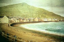
Before leaving the beach at Peel let us look back fifty years and bring to mind what it was then like and the changes that have been wrought since.
Starting at the harbour mouth, we notice that the head of the old pier is built of red sand-stone blocks. The action of the sea has eaten away the mortar between each section and now the crevices are filled with mussels. The face of the stones is covered with carrageen moss, as as we lads called it, "ladies' dullish," a home for myriads of "Harry, crabs," those horrid-looking sea lice, and a more uncommon crab with flat flappers — its name I do not know.
The pools on the shore at this time abounded with life — small crabs and fishes — whilst the boys of the town, in the summer time, would amuse themselves by wading into the sea and with a fork tied to a stick, an imitation of the "lister" used by their fathers, strike it into the plaice which were then so numerous, and soon provide themselves with sufficient for a meal. When the tide was in fishing was good from the pier, the gilpins caught being strung on a line to a length of two or three feet.
This state of things was put an end to, however, when the Foxdale mines were in full swing. The lead water sent down killed all algæ, also the mussels; and so poisonous was its effect that it drove all the fish away from the bay and the rocks around Peel Castle.
The shore next to the pier was called Munns, after an old ex-naval officer, who lived in the house across the road (Crown Street), from the Rocket House, or Board of Trade premises. This house was known as Munn's Gable, the wall facing the sea being double the usual depth to withstand the beating of the seas which at that time swept over the shore wall.
[FPC - the following painting illustrates Cowley's description
Part of 1860s painting (in Ward Library Peel showing bay and divisions before 1930s development ]
The shore itself was much deeper all along the shore road than at present, and divided into three parts. Munn's shore extended to the Rocket House; the next division to opposite the Marine Hotel, where the shelter now stands. The remaining shore also had a division at one time, but it had been destroyed by the sea. That one was opposite the house called Sea View, where the late Mr. R. Corrin lived. These divisions were called "land-rudges," and really, were stone groins built to retain the sand in its place. On a level with the roadway, they slopped away to nothing at the sea ends, and were built with blocks of red sand-stone and of a semi-circular shape. The two mentioned are still on the shore, buried beneath the sand.
My grandmother told me that once a windmill stood out towards the bay on Munn's shore, and a house with a step before the door. The sea gradually encroached and carried both away. One day, a little girl was sitting on the step of the door, when a wave came in and lifted her up and floated her out to sea. The clothes of the little one filled with air,. like a balloon, which kept her afloat until rescued.
I remember a small yacht coming alongside the first land-bridge, and by some cause being upset when the tide came in. Many feet of sand now cover this point. Gibbin, or sand eels, were at that time very plentiful on the beach, and in most houses along the shore was to be found a gibbin-fork or Look. Below where the fountain stands on the shore wall was the outlet of the town sewer. It was the custom of the boys on Saturday morning to arm themselves with the kitchen shovels, go down to this place and amuse themselves. The opening was square, and large. Several boys would fill their shovels :with sand and at a word of command, all throw together the sand into the aperture; others would then rush in with theirs. and the result would be a stoppage of the outlet. This made the sewage back up into the streets and backyards, but by the time the irate women appeared on the shore, the boys were away; and what a scene there was when the sand was removed from the sewer mouth; it gushed all over the place and cut its way down to the sea in a miniature valley all its own.
Over the second division we drop four feet or so. The shore wall at this place was protected by huge stones kept in place by wood piles. On the wall itself headed into the flat stones on top at this place were two or three iron eye-bolts. probably to tie the boats to, as the water was quite deep here at full tide.
At the bottom of the Gill, now called Bridge Street, the shore wall was broken and the place used as a tip for all the rubbish, cinders, and, if old houses were being pulled down, debris from them. That is the explanation of the finding of so many coins at this place. After storms, the boys would go down with pieces of hoop ironfi [sic ?] and scrape between the stones for "Eagle and Child" pennies — and often get them. Bridge Street derives its name from the fact of a small footbridge crossing the stream which game down the "ghyll"; that, of course, being before any houses were built here.
From the bottom of Stanley. Road to the end house stood a sea wall without a hedge or wall, and a couple of hundred feet or so out on the beach a large stone was uncovered when the tide went out. It may still be seen. This stone was used as, a target by the coastguard men, and the boys used to search in the sand round about it for round cast-lead bullets.
The late Mr. Wm. Cashin, Custodian of Peel Castle, told me that there was a fort on the shore, further over. Walking there one day, when the tide was low, I picked up a cannon ball encrusted with gravel. The mark of the casting was still upon it when the gravel casing was removed. This may be inspected in the Insular Museum.
We now come to the "green" where the fishermen hauled up their boats for the winter months, tarred their ropes, spread their nets, etc.
The town ended here. Much could be written about the narrow-winding streets, the cellars used by smugglers; fairies, etc., which used to "take" about the green; but we must get on. —
A roadway leads from here, running about where the front gates of the promenade houses are. A wall of shore stones and earth on the right-hand side, and on the left, the shore. Why ever did men rush to spoil such a delightful spot? On a level with the roadway, for a considerable distance, had been washed up centuries ago a bank of stones-stones of all colours, some local, others brought by glacier action, many washed from the near-by red sandstone, or from the so-called coral banks containing encrihites. Then a dip — a long, low valley — extending a great length, in which one might be basking in the sun on a winter's day when a bitter cold North wind blew in from the sea. Then another rouyr, or ridge, not quite so deep; a hollow next, over a smaller ridge, down a slight incline, and on to the sandy beach. Creg Malin at the east end of the bay had even at that time been spoiled by quarrying stone, but now it has lost all resemblance to its former beauty. Close to its foot is to be noticed a clearance in the rocks. This is called a "barra" in Manx, and usually was made by fishermen on a rocky beach to draw their boats up. In this case, the "barra" was used by the builders of the Cathedral, Keep, etc., of Peel Castle:. when they obtained their stone from here.
Along the sea face of Creg Malin are numerous small caves, all of which are sea-washed every tide. Unlike those long caves of Peel Hill, these are rounded at the far end and of a uniform colour, generally red, and smooth. One of these entered at the sea end, brings the explorer into the bath on Traie fo Goaig, but is now sealed up at that end. The name, "Traie fo Goaig" means the shore under the decline or declivity, and is one of the very few bearing a Manx name in this locality.
The name only applies to the little shore where the bath is, and not to the longer shore beyond the first point, which is Cain's Shore. A decent-sized cave penetrates the cliff between the two shores, and a little further on is, if one may apply it, a flying buttress keeping the cliff from falling down.
These two shores were a happy hunting ground for pebble-seekers; but since so much gravel has been removed from them the semi-precious pebbles have become scarce.
Above Cain's Strand, on the top of the broogh, stands the Old Battery, once used as a training centre for the Royal Naval Reserve.
A roadway led off the beach at its further end, cut through the solid rock. Unfortunately, this is now impassable. The walls of the cutting contain pebbles in the rough state, and rare fossils from the old red sandstone have been obtained here. Bunches of samphire hang gracefully on the face of the cliff at this place, and, I think, now the only place in this district where it is to be obtained.
Between here and the Stack are two peculiar natural foundations — one a stone arch bridging over a small shore; and the other, a chimney-like opening in the rock, just sufficiently large for a small boy to climb through. On the face of the rock here is imbedded an iron eye-bolt. The only use for this would be to tie up a boat to it. A short distance further on is a fissure in the cliff. This was a fault in the sandstone, and removed to the lime kiln not far away, to be made into lime.
We can proceed further now only when the tide is out. It is worth waiting for, however, as hidden beneath the cliff is the prettiest and cleanest little shore on this coast. Round the first corner we come on a cave guarded by a huge stone, like a wool-sack. The cave itself is wide, but not deep, and has the broad, rounded, smooth end. Next corner, another flying buttress, larger than the one on Cain's Strand. Each tide washes the whole of the beach. Isolated rocks, containing pools, the home of many variagated sea anemones, are also a feature of this place.
Arriving at the Stack, we have now to climb up a spurs of the cliff. The Stack is not surrounded by water, and it is possible to climb on to it from the land side. The cliff scenery here is quite good, but better if seen from the sea. Just before reaching the stone hedge, a fair sized cave runs through the rock to come out at a different place, and in an alcove are several brown stalactites on the roof. A few yards on the other side of the stone fence is the lime-kiln mentioned. Below it on the front of the cliff, was evidently at one time limestone formation. This has all been removed, and the kiln for many years has been deserted.
Just beyond here may, be traced in the field a declension. This marks the course of the "Officer's Cave," one of the longest on this line of coast. It is difficult of access, and then only at low tide. At its far end there were at one time a number of fine stalactites dropping from the roof; but they have been mostly all removed. The cave gets its name from the coastguard offices, as at the mouth of the cave is a crab-hole where they were always sure of a crab. I once saw a shark. swimming back-ward and forward before the entrance to the cave when the tide was full. A straight line of rock runs along now, until we come to a hole in the ground Just below the cliff path. This drops into a cave of no large extent, which may be entered from the sea. The next cave before rounding the corner is a small one rïunning straight in and emerging in the Lhoob. This is the best fishing place along here, fishing being obtained at any state: of the tide. conger-eels being a speciality. The Lhoob is a right-hand bend forming a small bay, sheltered from the west, and means "The waste"; Lhoob ny Rheest.
The path runs along higher ground note, and below the next stone wall is the largest cave we shall visit. The sea opening is quite large, and soon joins the main cave, which runs parallel with the cliff, its course being traced on the face outside by a crack in the rock. Exploring the interior is rather difficult, because of the number of large boulders to be climbed over, but it is well worth the trouble. The exit on the east side comes out in the face of a small cliff near to a landslip which occurred here about 40 years ago. The cause of the slip was the falling-in of several small caves on the beach beneath Apart from a pleasure walk, there is nothing of importance until we come to a descent to the stream coming through a narrow gorge dividing Ballagyr from Lhergydhoo. Its name is Cass Struan, i.e., Foot of the Stream. Getting, on to :he shore we come back towards Peel under the cliff, to visit a little cliff over which a lime impregnated trickle of water slowly flow, changing the living green moss into a fawn network of petrified moss. Cass Struan is divided from Lhergydhoo shore by a jutting wail of rock. At the sea end, however, it has been quarried away. and it is not difficult to proceed. The further shore was, until recently, a delightful picnic resort; but the removal of gravel to send to Douglas to build the promenade has marred it badly. A stream empties upon this shore also, coming down through Quaggan's Glen. It was in this glen that the last calf to be burnt alive was offered as a preventive to witchcraft in the Island, and that not so very long ago.
The broogh has to be climbed here by a narrow pathway, which runs over two pretty little caves at the end of the shore, and in a short time a much smaller beach is reached. Here, in the cliff-side, is an opening cut into the rock many years ago by, miners searching for metal. There is a similar one a few hundred yards further on.
Now we can either climb up to the path again or wander through a maze amongst the rocks to the next shore. The latter is not unlike the trenches we read so much about during the Great War, only these are cut out of solid rock by the action of the sea, and well worth exploring. If we go by the pathway we pass by a bore which was made when the Island was being examined by miners for coal. The place is now overgrown by grass.
White Strand is now reached. Here, again, is devastation. A shore once so beautiful, now a wreck. Thousands of loads of gravel every winter have been drawn from here and sent by rail to Douglas, to be made into cement blocks for the new promenade, and the work is still being carried on. The only way the damage can be repaired. from a beauty point of view. is for the brooghs of sand to gradually slip down and reform the beach.
However, let us go over, it. like I have done this day, the 26th of December, 1933. The west end of the beach is covered by a coating of black water oozing out of the sand with a noxious smell. This is the result of seaweed being washed in time after time, then covered with sand, and decaying. It has now been exposed to the air by the gravel having been removed; but a gale of wind blowing in a heavy sea may clean it up. Several years ago, I remember a huge porpoise being buried in the sand here; it had been washed ashore dead. The most outstanding feature of this beach is now to be observed and studied better than ever before. I refer to the wonderful collection of erratic boulders transported by icebergs from their original site. Grey granite and green millstone grit plum-pudding conglomerate, greenstone of all sizes. polished and rounded by the action of ice and sea, and they form a collection not to be surpassed. on the Island.
Walking along the beach, where once was a gradual sloping embankment of small gravel and sand. one is confronted by boulders which continue nearly to the end of the strand. In places the sedimentary clay is exposed. or disintegrating rock, in which is embedded stone which has not been sïabjected to the action of the sea. Whilst examining the latter, I picked up a small meteorite, about 2 inches long by one in diameter. A fine stone axe-head was found many years ago lying on the surface of the broogh above here, and in the fields behind the topmost peak are sometimes exposed cists of prehistoric burials.. The seaward stretches of sand are still available for bathing at low-water, and many specimens of shell life, including razor fish, are to be found.
Leaving the White Strand and crossing a bar of rock, we enter upon Will's Strand. Here we have a most interesting little beach to geologists. The red sandstone is impregnated with pebbles of all hues, whilst at the far end much disturbance of the rock is to be observed. This beach is also known as Traie Skeddan. To quote Sir Boyd Dawkins: "Here the crushing is most marked, the sandstone being crushed into the marls, and both presenting characteristic cuticular shearing structure. The whole of the headland on the north is sheared, folded and broken up to the northern boundary fault, the dull red sand-stones being folded and the thin interstratified marls being crushed and squeezed out of their normal position."
Nature has been known to present in rock foundations in many places outlines of human faces and forms, and here is one which I discovered some years ago and named. It takes the form of a recumbent old gentleman wearing a turban, and the owner of a very pointed nose.
It is not difficult to gain access to the next beach over the rocks. Its name is Wood's Strand; a very clean, open place to bathe or picnic upon. At its east end is a cavern with three openings under the headland, well worth exploring.
Quite a number of small beaches, handsome -rock scenery, sheer cliffs, etc., follow in succession from this onwards; too many to describe in detail; so we pass along until we reach Lynauge Beach. The caves on the west end of this delightful and un-spoilt beach are now called Gob-y-Deigan; wrongly so, as the Gob-y-Deigan is at the east end. Lynauge Caves is the correct name. Unlike those caves of Peel Hill, which I have described in a previous paper, these are accessible to anyone taking ordinary care. but it is necessary to ascertain the state of the tide and enter them when the tide is ebbing.
It is rather interesting reading what Dr. Haviland said at a meeting of the Manx Geographical Society in 1890, after they had visited these caves. He said that the caves were evidence of what the sea could do. The rocks, instead of showing the ordinary stratifications and laminations, were in large blocks. and had lost all their original character of sedimentary rocks; they showed signs of great pressure and heat, and if there had been animal life. it would be totally obliterated. They contained, which he had not observed before to such an extent in the Island, the remains of a very much older rock — the old Cambrian rocks. A remarkable fact was that some of the caves were capable of recent origin, but others, from their height, showed that they were formed when the land was much more depressed than at present.
The headland at the west end of the beach is Gob Gorrym. Leaving the caves, and walking along the beach, one notices the black or blue rotten slate, or blue clay, underlying the surface and being pushed on to the beach by the overlay. This, in one place, has caused the railway line above to be constantly inspected. as, since the railway was opened, there has been a subsidence of about 22 feet.
The beach itself is always clean and the other mass of rock is a great place for crabs. The empty shells of a small variety of cowrie are to be found in places, whilst some of the many circular rock pools contain so much beautiful algae and sea life as to be miniature aquariums.
At the east end of the beach we are brought up against a high cliff, running into the sea and forming Gob-y-Deigan, i.e., "The Devil's Mouth." At the land end is a small cave, above which a pair of ravens yearly build their nest. Looking at the lower centre of the cliff face, a semi-circular crevice is to be ,observed,: and this as seen from the top of the brooghs at the other end of the shore causes an optical illusion: the result of looking at it for a little while is that the semi-circle assumes the appearance of an archway through which one might pass under to the shore seen beyond the cliff.
During the time of the smugglers, this beach was the scene of many landings of illicit cargoes. A relative of mine, whose father helped in the work, told me that the cargoes landed here were not, as a rule, sold in the Island. It was in the event of a ship having to unload because of being chased by Revenue cutters; or part of an unsold cargo, or through any case unforeseen, the stuff was hidden here. A 'cave' or hole was excavated in the side of the broogh and the walls inside built up with loose shore stones; the hole narrowed at the mouth. and a tub or half-cask was placed in it. This was filled with earth, covered with green sods of earth, and the place left until such time as the opportunity came to remove it.
Not so many years ago one of these 'caves' was carried away by a slip of land and the shore was strewn with tobacco leaf, being part of a cargo which had been hidden and not reclaimed. The old cart track. now disused, takes us up zig-zag to Lynauge. i.e., the meadow farm house, from which a delightful view of the coast-line to Peel, three miles away, is obtained. An easy walk follows and an hour finds us back in the city of Peel.
I inspected the White Strand on January 19th, 1936, and found the character of the beach and brooghs vastly changed. Denudation of the beach of gravel has ceased two winters ago, shortly after writing the foregoing paper, and it is estimated that 30,000 loads had been removed and sent to help build the Douglas Promenade At the foot of the broogh had been left a strip of gravel broad enough to cart over. The latter has, during the recent high tides and gales of wind, been all swept away, and I estimate that at the centre sweep of the shore the sea has encroached 28 feet into the broogh, most of the damage having been done on the 11th of this month. Where the sand has been washed away, a number of boulders are now exposed, not the least interesting of which are several blocks of lime-stone. Most of the sand removed by the sea. now lies at the, east end of the beach, covering the rocks and forming a delightful bathing place. In the years to come, this will probably be added to as there are yet thousands of tons of sand ready to slip on to the beach. Unfortunately, the cart road to the shore has suffered badly, as where it now ends it is twenty feet above, shore level, and bathers will have to make their own pathways by tramping down the sand. The whole length of the bottom of the brooghs were damaged. and where the first ridge of red sandstone crosses the beach. six feet of gravel to the east and four feet to the west. in depth, was removed. A second ridge of sandstone hitherto covered at the east end of the beach is now also exposed.
|
|
|
|
|
|
||
|
Any comments, errors or omissions
gratefully received MNB
Editor |
||