[from Proc IoMNH&ASoc vol 4 #2 1936]
During the Summer of 1935 the following excursions of the Society were arranged:
16th May-Excursion to Ayre Lands. Leaders: Messrs H. M. Rogers and W. S. Cowin.
13th June-Excursion to Braddan Gravel Pits, Poortown Quarry and Peel Sandstone Quarry. Leader: Mr G. J. H. Neely.
11th July-A Tour of places mentioned in the Chronicles - Ballasalla District. Leader: Mr. W. . Cubbon.
22nd August-Excursion to the Kew, Manannan's Chair, Gob-y-Deigan, Corvalley Cairn and Orrisdale Circle. Leader: Mr. G. J.
H. Neely.
19th September-Excursion to the Braaid. Leader: Professor Fleure. Followed by visit to the White Well at Dreemlang and the
Cairn on Kennaa.
The members met at Gob-gorm (Blue Point) and walked to the shore. The diving of the gannets was first seen and was a wonderful display.
Much interest was shown in the shallow scrapes in which the eggs of the Oyster Catcher and Ringed Plover were found and the great difficulty in locating them.
On the Ayre Lands, the nests of the Lapwing, Skylark and Meadow Pipit were examined, and also of a Robin which had built its nest in a very dark hole in an old building.
Mr. Rogers had hoped to show the members the nest of the Redshank, but unfortunately, this had been robbed some days before the excursion.
The weather was sunny and dry, but owing to a high wind many of the smaller birds were not on the wing.
The party proceeded to Ballakinnag and rejoined the cars, and then to Ramsey.
This excursion was arranged by the Physiogaphy Section, and was to have been led by Mr. R. B. Moore, H.M. Attorney General. Unfortunately, pressure of public business prevented Mr. Moore's attendance; and in his absence, Mr. Neely was requested to act as leader.
A special motor coach left Rosemount at 2 p.m., for the Braddan Gravel Pits, which were reached about 15 minutes later. Mr. Kniveton, the proprietor of the works, who had arranged to meet the party, was also unable to be present, owing to a sudden bereavement. In his absence, the foreman kindly consented to conduct the members over the site, which he did most efficiently. The party were shown the various methods of screening gravel, and the preparation of materials, such as mortar, etc., for building purposes.
Much interest was shown in the varied stratification disclosed by deep cuttings round about the west end of the works. A large number of fossils, collected by Mr. Kniveton, and consisting of sponges,corals, crinoids, etc., were exhibited. These were handed to Mr. Neely, who deposited them at the Manx Museum.
A vote of thanks to the foreman„ for conducting the party around the works, was passed. There were, also, many expressions of sympathy for Mr. Kniveton, on account of the sad news of his brother's death.
Resuming their seats in the motor coach, the members left Braddan for Poortown Quarry, which was reached about 3.30 p.m. Here they were met by Mr. R. C. W. Brown, Surveyor General, who conducted them through the works. Mr. Brown gave a most interesting description of the quarry, its development, output, etc., and described the characteristics of the handsome dark green porphyritic rock which is obtained there.
The party were also shown the efficient machinery, erected by the Highway Board, for breaking the stone, and grading it for the purposes of the highways.
The Surveyor General was thanked very heartily for the trouble he had taken on behalf of the members.
The route was now continued to Peel, which was reached shortly after 4 p.m. Leaving the motor coach, the party proceeded on foot to the eastern end of the promenade, where the red and mottled sandstones, with bands of pebbly conglomerates, in the neighbourhood of Creg Malin and Traie Fogog. were seen and discussed. The Peel sandstones actually occupy a strip of coast about 14 miles in length, but time did not permit of any more extensive examination than that mentioned.
The leader pointed out that scarcely any material in the pebbly layers was derived from the Manx slates-as in the Carboniferous Basement Conglomerate of the South of the Island.
Lamplough, who wrote the "Geology of the Isle of Man," thought that the Peel sandstones were probably not newer than the Lower Carboniferous.
After having tea at Peel, the party. returned to Douglas.
On Thursday, 22nd August, 1936, an excursion was undertaken to the district round about Corvalley, German.
The leader was Mr. G. J. H. Neely.
A motor coach left Rosemount, Douglas, at 2 p.m., for St. John's, where the remainder of the party joined. Altogether, the members were conveyed in 11 cars.
From St. John's, a visit was paid to the Kew Passage Grave. The approach to the chamber (now destroyed) was by two lines of stones, standing vertically, and forming a passage which was formerly probably roofed with capstones. A large bank, built some years ago, has intersected the line of the passage, and cut off the site of the chamber-which is now in the adjacent field.
The leader described the monument as being unique, so far as the Isle of Man is concerned. The nearest examples of similar burial sites, i.e., passage graves, being in the Channel Islands; the finest being in La Hougue Bie, Jersey.
The route taken on leaving Kew was by the Staarvey Road (Bayr ny Maynaghyn) to Manannan's Chair, or Managhan's Chair; a circular earthwork, the outer ring of which (now mostly destroyed) appears to have been about 50 yards in diameter. It is said that flint implements have been found here, which may, be evidence of very early occupation; but most of the Camps or Forts of similar type that have been examined, have been attributed to the early Iron Age, or late Celtic Period. The next place to be visited was the Gob-y-Deigan, on the coast of German. The state of the tide did not permit of any visit being paid to the caves in the neighbourhood. The name is supposed to have been derived from "Dagon" (God of the Philistines), the name adopted for a succession of boats built at Peel, one of which may have been wrecked here. No records in writing are available.
A short delay was made here to enable the members to enjoy the magnificent coastal view. after which a short journey brought the party to the Corvalley Cairn.
The Corvalley Cairn is a prominent object east of the road near Glen Cam. One chamber has been exposed and cleared of anything of archaeological value which it may have contained.
There are probably other chambers, and assuming that the whole monument is composed of large white quartz blocks, similar to the exposed chamber, much may be learned from excavation, regarding this and other ancient monuments of the same material.
Shortly after 5 p.m., the route was resumed for Glen Wyllin, where tea was served.
The last object of interest to be visited was Orrisdale Circle, which was reached about 6.45 p.m.
This Circle is also composed of white quartz blocks, of which, unfortunately, only four remain in position. Two more are to be seen used as gate posts in the same field near to the monument.
Mr. Philip Kneen told the Ordnance Surveyors in 1866 that he remembered more blocks being in the Circle, and that urns had been found.
This completed the itinerary, and while many of the members found it convenient to return by Kirk Michael, the main body proceeded via Ramsey to Douglas, which was reached about 3.30 p.m.
Cars left the Braaid, where Professor Fleure had been describing the remains. Mr. W. Cubbon took charge of the party. Dreemlang House was first visited. A very large number of white quartz boulders was pointed out, resting along one side of the pathway from the entrance gate to the house. These, said the leader, had been taken from the field across the road, in which the White Well was situated.
A school for young gentlemen was conducted here in the 1860s and 70s by the Rev. John McMullen. He is said to have been the first to cultivate the field across the road, in which is, the White Well. It should be noted that several boys who became eminent were taught in McMullen's school. One was the father of the poet, W. B. Yeats. Yeats' sister, in a letter, describes the schoolmaster as "a fierce old Scotchman."
There are on the summit of the field opposite a number of peculiar dish-shaped hollows. It is difficult to say what they originally were. They may reasonably be thought to be the remains of foundations of Hut Dwellings.
The edges of the hollows have been worn down by the plough, but they still show a considerable depth and retain their circular shape. They have never been examined.
The only printed reference to this was in Brown's Guide, written by Mr. T. Grindley. He was the parish schoolmaster about 1870.
The White Well, he says, is built entirely of great blocks of quartz, some of them several tons in weight, the existence of which was, until within the last few years, only known to the inhabitants of the immediate neighbourhood. The blocks are accurately joined without water or cement. Before the land was brought into cultivation_, which was about seventeen years, ago [that would be about 1870], the well was always full of excellent water. The opening into the well is about five feet wide, but it originally ran some yards further back, as the quartz blocks forming the retaining wall can be traced to some distance. the tops projecting over the soil.
There is nothing, he continues, to indicate the period of its construction, as there is probably nothing like it in the British Isles. Probably it was built by the Druids. and used in their religious ceremonies at the admission of neophytes into their order; or it may be of earlier date. The retaining wall runs due east and west, and the opening is to the tues,. This may indicate some connection with sun worship.
Mr Grindley believed that what the now see are the remains of a sacred well. I have examined the site many times. I cannot see that there is any proof of there having been a well here. There is no evidence that there was running water. But the cavity that you see gathers the surface water.
There are signs of many large quartz boulders under the sod. The appearance of the site suggests a Barrow. On the other hand, it might only be an out-crop of quartz.
There are the remains of a Keeill in one of the fields on Ballachrink farm, to the south of us. The Saint to whom it was dedicated is not known. The site is in the corner of the second field below. Almost all the stones of the walls have been removed.
Mr Kermode thought the Keeill had been built on the site of a Bronze Age burial place.
A very remarkable monument is this Cairn of Kenaa. It is set down on the Ordnance Plan as a "cairn," 574 feet above sea level. There is not another anything like it in the Island.
The nearest to it is thre circle of white boulders at Billown. But there are many wide differences between them. It is, as you see, a Ring of about 18 yards, N. & S., 15 yards E. & W.. The bank is 5 feet high.
In the face of the outer bank, there are many large quartz. boulders. I have counted at least ten. They are significant. The bank seems to be of rubble. It is, at the base at least, 12 feet thick and 5 feet high.
In the centre is a cist, 5 feet by 3 feet, with a covering slab of slate. There is a tradition that the cist was opened before the year 1870. Whether anything was found in it, we do not know.
Attached to the cist is this very wholesome story: The man who opened it accidentally cut one of his fingers, the result being that his whole hand had to be amputated.
It will be useful to quote the Ordnance Survey record of the Kenaa Cairn, sent to Mr. Cubbon on request:
A circular heap or mound of stones. Surface covered with earth. The base is composed of large quartz stones and is about 57ft. in diameter. The interior has been removed for building purposes, thus exposing a large stone Gist which contained human remains. The cist is still visible and placed in centre of cairn; the latter as it at present stands is about 5ft. high and 57ft. in diameter, with centre hollowed out.
The authorities given for these details were Mr John Mylchreest, Peel; Mr Edward Creer, Ballacurry, and Dr. Oliver. The leader said he could not conceive that the interior had been removed; such a thing was very unlikely.
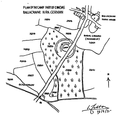
The party walked on to Kenaa House, and from thence took cars to the Camp at Ballacraine.
Mr. Cubbon quoted the details noted by the Ordnance Survey officers in 1869, as follow:
Situated a few chains from Ballacraine Inn on the main road to Castletown are the remains of an ancient encampment or enclosure in an almost perfect state of preservation. The high road bisects it, and has destroyed a portion of the inner circle and central mound. Dr. Oliver states this place of meeting to be ancient judicial or Thing hill analogies to the Tynwald mound. In its original condition a small streamlet encircled the space between the inner and outer circumcallations. These remains are indentical with those on the Clannagh Road near to St. Mark's, Kirk Santan parish.
This seems to be the only example of a Crannog we have in the Island. They are numerous in Scotland and Ireland. They are usually constructed on islets in the bogs. They were adapted for occupation, and fortified by single or double lines of stockaded defences drawn round the margin. This one has a double line of defence.
Usually, in the middle was placed stone-paved hearths. As to the date of these Crannogs, they cover various periods. The relics discovered in Ireland are of pre-Roman date. Besides weapons and implements of iron, there are fibula and brooches of bronze, and spindle whorls.
The outer vallum or rampart commences at the hedge to the north and goes round in a large circle towards the road. The road was originally included. There is a portion of the outer rampart in the field to the left of the road. The ditch between the outer and inner rampart is wide and must have been originally very deep. The means of access or causeway from the outer to the inner rampart was near the present hedge to the north.
The area of the whole Camp to the margin of the boggy land is 100 yards in diameter. The area of the higher space within the inner rampart is comparatively large, about 30 yards in diameter. The Camp was well protected. It was surrounded by over eight acres of boggy land. The women and children and even the cattle would be kept here.
The place names associated with this place are interesting. The little estate on which the Camp stands is called Scravorley (Scra-voalley). This, Mr Kneen suggests, means the mire rampart, or mound. The earth-work itself is locally known as "Port-y-Candas." Mr Kneen says that in this case, `Port' means a fortress or military station. Prof. Joyce says it means a royal fort, a chieftain's residence. Ceanannus was, in Ireland, a circular earthern fort or Dun in which the King or Chieftain resided.
The field below the farm-house of Ballacraine was an ancient Fair Ground. Mr Kneen tells us that the old name of the farm was "Bailey-ny-hoaie," i.e., "Farm of the Graves."
There was something sacred about the mound on the north side of the field adjoining the road. It is said locally that it is the grave of Mananan-Beg, the son of Leirr, the God of the Sea.
The late Mr. Cowley, who lived in the house opposite, told me that it was here at this point that Mananan spun the mists which he, from time to time, enveloped the Island, in order to keen it from its enemies. The late Mr Kennaugh, the blacksmith, remembered, when a boy, the excavation of the mound at the south side. A stone grave was uncovered and the soil put back again. Mr. Kermode had a record that urns were found. The main road between the mound and the cow-house goes over a cemetery. In the cowhouse itself may be seen the covering slabs of graves. These, I am informed by Mr. Quilliam, all run east and west.
The Ordnance Survey account of the remains of the burial ground at Ballacraine farm-house should be quoted for the purpose of record.
This ancient burial ground is situated close to Ballacraine on the inain road leading from Douglas to Peel. The high road bisects it and has destroyed a portion of the mound which originally was of a very extensive nature. Whilst excavating for the foundations of some out-buildings a number of stonelined graves were discovered containing human remains. There is no doubt this must have formed a portion of the burial ground. The rernaining portion is covered with stone coffins, the tops of which in several places are visible; two of these graves have been opened and found to contain human remains.
The above particulars were vouched by Dr. Oliver. Mr. Fargher, and Mr. Garratt.
W. C.
|
|
||

|
|
|
|
|
||
| Any comments, errors or omissions gratefully received MNB
Editor HTML Transcription © F.Coakley , 2010 |
||