Plan of Remains known as "Bushell's House," on Calf of Man.
[From Proc IoMNH&ASoc vol 3]
PAPERS AND REPORTS - Read Nov. 19th, 1931.
G. J. H. NEELY.
Visits to the Calf of Man, by this Society, have been so rare in the past, that it has been suggested that some special notice should be made of the excursion on September 17th last. With this in view, the Committee have requested those of our members who took a leading part in the Excursion, to render a short account of the activities of their sections to this meeting, for inclusion later in the Society's " Proceedings."
Of the former Excursions to the Calf, the first, on July 11th, 1907, was led by Mr Patterson. The second, on 2nd August, 1919, was led by Mr P. G. Ralfe. On the first occasion, the Society had the great advantage of having with them the late Professor W. Boyd Dawkins, who gave an account of the Geology of the Calf Island, and its relation to the main mass of the Isle of Man-showing that the Calf Island, and the Chickens, were an extension of the general axis of the main island.
The Calf of Man in roughly 12 miles long from N.E. to S.W., and about 1 mile wide across the centre at right angles to this line. It has an area of about 6162 acres, of which, at the time of the Survey of the islet, 490 acres were covered with rough heathy pasture, or foreshore; the remaining 1262 acres being arable and pasture land. The highest point on the island is 421 feet above mean sea level.
The morning of 17th September last was dull and threatening, and the sea choppy. Nevertheless, 53 members and friends were taken by motor boats from Port Erin, or from the Sound, to Cow Harbour on the Calf Island, all being landed by about 12 noon.
Here the party was assembled by the Leader, Rev E. H.Stenning, M.A., who proceeded to give a general description of the islet, including a comprehensive account of its geological structure..
At the conclusion of this interesting and instructive preliminary address, the members were taken on a perambulation of the principal points of interest. At each place or object visited, a short descriptive account was given by the Leader.
Early in the afternoon a visit was paid to the farmhouse, where tea, very generously provided by Mr Popplewell, the Owner of the Calf Island, was served by Mrs Maddrell, assisted by a number of the ladies. At the close of this much appreciated function, a hearty vote of thanks to all concerned in providing the hospitality was unanimously passed.
At 3 p.m. Mr Stenning, the Leader, had to return to the main island, much to the regret of everybody present; and the members now formed into small parties or groups, and carried on with the work of obtaining what information they could in each branch of the ,Society's activities.
We were fortunate in having with us Miss Herdman, M.Sc., and Miss Parke, B.Sc., of the Marine Biological Station; also Mr Cyril L Paton, who led those of the party interested in an investigation of the plant life of the islet. Mr W. Cubbon acted as Leader of one .of the Archaeological groups, while Mr P. G. Ralfe led those members who wished to study bird life.
The members and their friends were conveyed safely back to the main island at 5 p.m., after a very successful day.
" BUSHELL'S HOUSE " (so-called).
A Report by J. R. BRUCE, M.Sc., and G. J. H. NEELY.
The time available on the Island being brief, it was thought -desirable to focus attention upon one problem, rather than to attempt a general archaeological survey, which would, of necessity, have been :superficial and incomplete.
The problem was to obtain definite information regarding the site and character of the ancient chapel or 'keeill' which is known to have existed at one time on the Calf of Man. The published and traditional evidence bearing upon the site is of a conflicting nature, which may be partly explained upon the assumption that there was originally more than one chapel, and partly by the disturbing influence of Thomas Bushell (1626), to whose eccentric genius have been attributed, on the slightest of evidence, all sorts of constructions and happenings.
On Durham's Map of the Isle of Man, 1595 (published by Speed, 1605), a chapel is shown, at about the centre of the Calf Islet, but the scale is very small-about 24 mlies to 1 inch. This location is followed by several maps of later date, which are apparently only copies of Durham's map. Cumming, in his "Guide to the Isle of Man," (1861), states that "there are some remains of a chapel near "the house occupied by the farmer. . . . . on the road between the "Cow Harbour and the lighthouses. This chapel is given in the map of the Isle of Man by Thomas Durham, 1595. In it have been found remains of Scandinavian monuments; one, now in the possession of the Clerk of the Rolls, Castletown, bears upon it a remarkable carving of the Crucifixion." Cumming's placing of the keeill near the farmhouse is compatible with a statement made to one of us by Mr Wm. Christian, of Port Erin, in July, 1931, when he said that his father and mother, when they worked on the Calf, used to say that the "little church" was in the field in front of the house - i.e., the present farm-house. During the excursion, a rapid but careful search was made by the writers, and by Mr Wm. Cubbon, of the borders of the field in question, but no trace of foundations could be seen. Further search will be necessary when crops permit, but we were informed by the tenant-farmer that he had never come across large stones or foundations when ploughing the field, and knew of no tradition concerning it.
If the presence of early Christian interments of the 'lintel-grave' type may be taken as presumptive evidence of the proximity of a keeill, and in the Isle of Man such association is frequent, then quite another site is indicated, since a group of at least, four such graves were uncovered, on the site of extensions to the now unoccupied farm-building on the North slope of the Calf, visible from the main island. This was between 1888 and 1890, as we were informed by an eye-witness, Mr T. Karran, of Port Erin, in October, 1931. Mr Karran added that two of the graves were actually built over when the new walling was put up. This site was not examined during the excursion.
Yet a third site remains to be considered, and while the evidence bearing upon it, of a traditional or documentary character, is considerable, the actual remains on the ground, which we carefully examined, are of a most perplexing character, and certainly not compatible with any known type of keeill. The site in question is on the highest point of the Calf Island, almost at the edge of a precipitous cliff, 420ft. above sea level. On the Ordnance plan of 1867, there is shown at this spot "Bushell's House, on site of Chapel and Burial Ground," the authorities for this designation, as given in the Object Name Book kept at the Survey Office, Southampton, being Captain Carey, M. M. Mechin, Esq., and 1\T. Quayle, Esq. All these gentlemen had the most intimate associations with the Calf,. and their testimony, as to the site of Chapel and Burial Ground,. cannot lightly be dismissed. The fact, too, that the child of a lighthouse keeper, who died on the island, was taken to this spot for burial, would seem to imply some tradition of sanctity. Whatever may have been the earliest uses of the site, however, tradition and the popular voice hail it as the spot where Thomas Bushell, courtier, prospector, and recluse, spent a period of his life in religious contemplation, about 1626. The fragmentary remains on the site have been described, in "Manx Notes and Queries" (1904), p.62, by a writer who even goes so far as to identify a small recess with Bushell's bedroom! The description, loose and inaccurate in detail, has been adopted by Bushell's latest. biographer 1 who accepts, too, the site as being that of Bushell's residence. -
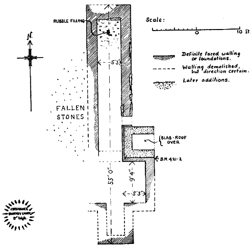
Plan of Remains known as "Bushell's House," on Calf of Man.
The conclusion emerges, therefore, that whether the remains be those of Bushell's House, or of some ecclesiastical structure of undescribed type, or possibly of fragments of both, they call for careful description and measurement, as a basis for any detailed examination, with excavation, in future.
The remains consist (Fig. I), primarily, of the lowest courses of a narrow rectangular building, 55ft long, aligned due north and south. On the East side, an opening, 2ft. wide, appears to be an original entrance, while on the same side a projecting wing forms, as it were, a 'transept' to the main structure; there are indications, also, of . counterpart to this wing on the west side. The foundation of a eross-wall, as between the north sides of the wings, is faintly perceptible, and it is just possible that the entire T-shaped area at the southern end, with its thinner walling, may be of different date from the rest of the structure. Except on the north-east side of the building, the walling can only be traced in interrupted lengths, and on the south-west side it is almost obliterated, but sufficient remains to justify the unsymmetrically cruciform plan suggested by our Fig. I. and by the Ordnance surveyors, and popularly recognised in a local poem, published in 1873.2
As for constructional detail, there are differences between the east and vest sides of the building. The west side, comparatively well-built, is practically only a stone revetting to the earth-bank beyond. while the free-standing east wall consists of a number of large upright slabs, connected by dry-walling of smaller stones, laid in roughly horizontal courses. It is not impossible that much of the dilapidation of the site was associated with the construction of the adjacent cairn by the Ordnance surveyors.
A small rectangular but or cell has been built in the north-east angle formed by the projecting wing. The date of this building, -while evidently much more recent than that of the main structure, is still anterior to 1867, since it appears on the ordnance sheet of that year. The walls, 2ft. in thickness, rest in part upon the old foundations. The roof, now partly demolished, was slabbed, and sloped down to the vest, from a wooden doorway on the east., of which the framing alone remains. This hut, about 5ft. in height, is now the most conspicuous feature on the site, and by some has been mistakenly associated with the traditions which properly belong to the older remains.
1 J. W. Gough, MA., "The Superlative Prodigall," Bristol, 1932.
2 Miss E. Nelson, "The Island Penitent," Manx Soc. Vol. XXI. The 5th stanza contains the lines:
"The hoary sinner rear'd that pile,
That time-worn cruciform."
We do not propose, at this stage, to hazard any view as to the origin, purpose, or date, of the building, but we hope on a future occasion to carry out such excavation as may be necessary to amplify the present plan, and possibly to throw further light on the nature of this problematical structure.
Revd. E. H. STENNING, M.A.
It would be unprofitable to conjecture in what manner the Calf became detached from the Main Island.
It lies as the nearest point to the deep water of the Irish Sea. The sea bottom which is of very considerable depth up to the foot of the cliffs of the Calf, shelves away quickly and soon passes below the 50 fathom mark.
Doubtless the subsidence which caused this deep basin, helped to bring about the separation of the islet.
There is no essential difference between the general structure of the Calf and of the main Island. It is a mass of slaty schist, denuded of all formations above, presumably by the same glacial agency which stripped the main Island, of the limestone and other layers which were formed upon it.
The Calf is rather less than a square mile in area. Its highest point- rises about 420 feet above mean sea level. The basic construction is a mass of schist-slate, with numerous greenstone dykes.
An interesting patch of drift gravel occupies a large portion of the district South and East of the Farm. Indeed, except for this patch of drift, the soil is singularly shallow, and but for the drift. no farm would have been possible.
The Geology of the Island is admirably treated in the Memoirs of the Geological Survey, "Isle of Man," G. W. Lamplugh, 1903. It is not collected there under the heading of "The Calf" as a separate entity, but is mentioned up and down the book in places where the interest is apparent.
Lamplugh quotes from Cumming, whose book on the Island contains much of the Geology of the Calf, mixed with general information (The Isle of Man. J. G. Cumming) 1847 p. 151 ff.
This present summary is a precis of the information in these two authorities.
The mass of the Calf forms a direct continuation of the mass of slate which includes Cronk ny Irrey Lhaa, the Carnanes, and the hills South of Port Erin. The cliffs rise sheer from the water round most of the coast, and there are only two places where landing is reasonably easy. There is a reef of slate running out to sea to the South, on which, about, 1,000 yards away, stands the Chickens Lighthouse.
An interesting wedge of thin flaggy grits, unsuitable for building purposes, strikes inland from Fold Point. It is brought to an end bv a Fault, which traverses the Island from near Fold Point, to the Puddle. This fault runs North and South. Its Northern limit is near Kiona Beg, and its Southern end rather West of the Eye The slates are interspersed with small traces of flags, which Lamplugh considers akin to the Lonan flags.
More especially in the South, the green dykes run in some profusion, close together and mainly in a direction West North-west to East South-east. They are very reminscent of the similar dykes of Langness, and their soft texture has similarly caused a number of gullies in which their structure and direction may be examined They are usually less than 4ft. in width, but there are some of 8ft. width. The widest is about 18ft. and seems to have been a continuation of that found in the cliffs near Spanish Head. It reappears again, too, in the Chickens Reef.*
In the breccia fillings of many fractures, metalliferous veins occur. Cumming states that he found one of Copper sulphide, 1846. Veins of lead and copper were known around Caigher Point.
Rock benches, and erosions of the sea above present water level, betoken the existence of raised beaches.
Miners consider the dykes and veins on the Calf and on Kitterland, and at the main island point of Aldrick, as closely related, or identical with the Bradda lode.
The Drift Deposits.-In these occur many drift stones, including much Foxdale granite. Many of the rock chips do not occur in the island. Long distance glacier transport is indicated. In places the gravel extends to a depth of 30ft.
Cumming, in the "Geology of the Isle of Man" thus describes the gravel-("Quarterly Journal Geolog. Soc. 1847, pp. 179-185. With section figure)
"The mass itself, about 13ft. thick and 50ft. across, consists of boulders gravel and sand, near the floor of the deposit. It contains only a few pebbles. As we ascend (the face of the cutting) the size of the fragments increases. We have a bed of fine, then coarse gravel, with good sized boulders, scratched and grooved. Most, if not all, the rocks are foreign. There are red and grey syenites, porphyries, and granitesgrit and sandstone either from Cumberland or South Scotland . . . . . there is not a single pebble of limestone. . . the stratification is not horizontal, but follows the contours of the hillock."
Kiitterland has a cap of similar gravel-drift.
Glacial Striae have been observed running N.N.V. and S.S.E. in exactly the same direction as in the rest of the Island.
As regards Metals, Chalmers' "Caledonia" vol. iii. p. 372, quoted by Cumming, says "John Comyn, Earl of Buchan, obtained from Edward I. a licence to dig for lead in the Calf of Man to cover eight towers of his castle of Cruggleton in Galloway."*
In the XV., XVI. and XVII Centuries, the Stanleys sought copper on the Calf. Traces of their workings may be found. The ore, though not abundant, was rich in quality, producing 6 dwt. of copper per ounce of ore. (Moore, Isle of Man, vol. 1 p. 307).
There are lead and copper veins to the North of Caigher Point. In the Athol catalogue of assets (1827) no mention is made of the Calf metals.
Fossils.-No fossils, animal or vegetable, remains have been recorded.
Cumming thinks the gravel bed entirely different from that at Castletown; he considers it produced by the debris from melting icebergs. In that case fossils and remains would be most unlikely.
*Cumming, p 151.
IV. Botanical & V. bird life - not scanned
|
|
||
|
|
|
|
|
|
||
|
Any comments, errors or omissions gratefully received
The Editor |
||