[from Proc IoMNH&ASoc vol2 #4 1926]
BY REV. CANON QUINE, M.A., Secretary of Archaeological Section.
30 April, 1925.
During the past year two independent pieces of research involving excavation have been carried out with interesting results, viz., the excavation of a keeill at Ballalough, in the parish of German, carried out by Mr. P. M. C. Kermode, and the excavation of a tumulus, under my direction, at Chibbyr Pherrick (Patrick's Well), in the parish of Lonan.
An account of the results of the excavation at Ballalough may, in due course, be expected from Mr. Kermode himself in a special report, or incorporated in the Archaeological Survey, in continuation of his accounts of the keeills. It may be noted here that the discovery of yet another cross slab is one of the results of this excavation.
Also, the following notes on the site in question may serve to call attention to the significance and value of the excavation of the Ballalough site.
About a mile out of Peel on the Poortown road, and a little way short of Ballalough farmstead and of Peel-road Station on the Manx Northern Railway, the highroad passes through a ridge of sandy land by a deep cutting, in the sides of which used to be visible the ends of stone-lined graves. The ridge, which is 160 feet above sea-level, is called on the O.S. map ' Cronk Keillaune '; and on the end of the ridge immediately south of the cutting the O.S. map has ' St. Mary's Chapel and Burial Ground.' - Keillaune is usually explained as the ' Keeill of the bell.'
The 12th century constitution of a diocese with Catholic organization in the Isle of Man-in place of the older Celtic or Columban system-modified in the 11th Century by the Danish-Manx element in the population, and their ' Kyrkes ' alternating with ' Keeills '-resulted in the old ecclesiastical lands being assigned as endowment to the newly organized institutions. Part of the lands devoted to religion remained devoted to what was probably their original purpose, viz., the Particles, for the support of persons preparing for the minstry of the Church; another part was devoted to form the Bishop's Barony, or an endowment for the newly constituted diicesan bishop; another part was granted to the various foreign religious orders, that had been constituted anew, e.g., Cistercians, Premonstratensians, and Benedictines more or less reformed on the ancient Benedictine rules. Small portions, also, were probably devoted to form glebes for the newly organized ' parish ' clergy.
In the parishes of German and Patrick we find these ancient ecclesiastical lands, amounting to 1,262 acres in Patrick and 3,057 acres in German. In Patrick parish the Irish Abbies of Bangor and Sabal obtained 774 acres at Ballelby in Dalby; the Bishop had 258 acres; and there were 230 acres that remained ' Particles ' till the Stanley confiscations in the 15th century. In German parish, the Premonstratensian Priory of Whithorn got 1,120 acres of land opposite to St. Trinian's (their Kirk Marown grant): the Cistercians of Rushen got 2,135 acres, inland from Peel and northwards along the coast; there remained 597 acres as Particles; the Bishop had 206 acres, out of which he allocated 21 acres as glebe to the Vicar of German, and seven acres to the Parish Clerk.
The Bishop had the rectories of German, Patrick, Jurby, and Braddan; and much the same sort of allocation of the old ecclesiastical lands was made in these several parishes; and also in Marown and Lezayre where the Whithorn Priory had the advowsons, and where Particles and Abbey Lands still enable the partitioning of the lands to be traced.
In Kirk German, the Bishop's Barony was that area north of the Poortown Road forming ' Ballakilmurra,' or the land of the Church of St. Mary.
Within living memory the old vicarage homestead was still standing on Kirk German glebe between Ballakilmurra homestead and the railway line, among the fields behind Ballalough homestead. The approach road was along the seaward side of the sandy ridge called on the O.S. map ' Cronk Keeillaune.' It may be confidently assumed that the keeill-excavated by Mr, Kermode-is the church or keeill that gave its name to Ballakilmurra; and that the land so designated extended so far as to include the ridge and the keeill site.
Referring to Manx Soc. Vol. IX (Oliver's Monumenta, vol.(iii), in the Charter of Confirmation of Lands to the Bishop (A.D. 1505), and in the catalogue of lands, pp. 28-29, the lands of ' Baly Mary' means the lands of ' Ballakilmurra.'
There can scarce be a doubt but that this keeill, therefore, was an important church, and of very remote antiquity.
A suggestion may be offered, as conclusion to this reference to Mr. Kermode's excavation, viz., that members of the Society will find it deeply interesting to work out, with Sheet IX O.S. six inch map and with Wood's Atlas, the ecclesiastical lands in German parish, abbeyland, barony, particles, and glebes, in order to realize better the endowments of the Celtic Church, prior to the Catholic organization introduced in the 12th century; and the re-apportionments then achieved.
The excavation of Chibbyr Pherrick consisted of the opening of a tumulus of late Bronze Age. It was undertaken during the past winter, with the permission of Messrs. Jas. and Wm. Kermode, of South Grawe; and with the assistance of Mr. Eastwood and Mr. A. Eastwood, of " Social Cottage," near Chibbyr Pherrick.
The tumulus stands at an elevation of 500 feet above sealevel, near the edge of the Grawe plateau, overlooking Glenroy, and with north-west aspect. Its position (vide 6 inch O.S. map) is at 54� 13' 20" N.; 4� 25' 20" W. Also, at 300 yards distance, nearly N.W. beyond the little ghyll below Chibbyr Pherrick, stood another tumulus, of at least equal size, which was destroyed about 80 years ago. Also, at 90 chains, or a little over a mile by air-line nearly W.N.W., is the stone cairn opened last year, containing a Cist with massive cover-slab, calcined bones, and two beads seemingly of jet; the latter at an altitude of 700 feet above sea-level.
Chibbyr Pherrick means the Well of Patrick. In past generations it was much frequented for cures. It is a perennial spring from under a brow of rock, filling a rocky basin about a foot deep, and overflowing into a little ghyll going down Lllergy Grawe to the Glenroy river. On the other side of the ghyll, thirty yards from the tumulus, is ' Spoot Phaddy,' a smaller perennial spring falling over a stone spout. ' Pherrick ' or ' Perrick ' is, of course, from Patrick; and Paddy or Phaddy from Palladius, the other apostle of Ireland, who left Ireland and passed over into Scotland, ending his ministry before Patrick began his more successful enterprise.
These questions have a certain interest connected with the site for the cronk or tumulus stands within ioo yards of the well across the little ghyll. Also, there is a massive menhir about 50 yards from the well on the same side of the ghyll, and over against the tumulus and ' Spoot Phaddy.'
The tumulus stood on a nearly circular base, that is, slightly oval in ground plan, with major axis about 62 feet in line from S.E. to N.W., and minor axis 56 feet. It was seemingly of earth; its height probably at one time nearly 12 feet above the field. The form of the tumulus has altered somewhat in the last 25 years, through having been ploughed over, and also worked with the spade for a crop or crops of potatoes. Formerly its skirt showed a terraced form; and one could imagine that the terrace was a worn down ring fence: that is to say that it had a form like that called ' bell-barrow.' But this is not here insisted on, more than as a recollection and impression..
The excavation of the mound was begun on the west side, nearly two-thirds of the way up from the base, and driven towards the centre. Stone was struck at a depth of a foot from the surface. Other cuttings were then made from the north and the east, in each case with the same result,-stone with a sloping face. The cutting was then continued from the west, and revealed the top of the stone-work, fairly level. This was followed to right and to left, showing the fairly level top of a wall, going round in circle, and tailing away outwards to the skirts of the mound; and within the wall again earth or hard clay.
In removing or cutting into the central or top parts of the mound, much debris of urns was found, one only rescued fairly whole, but this urn, having stood with mouth downwards, had the top part (i.e., the bottom of the urn) sheared away by the plough. This urn was removed to a place of safety; also one worked stone, rounded to form the lid of an urn, that is, of an urn set mouth downwards upon this stone. These urns were all in the upper strata of the mound, at least nine or ten feet above the field,
Proceeding further, we excavated the clay from within the wall, which proved to be an oval cup, at the bottom of which we found the flag-stone of a cist, and ultimately uncovered and examined the Cist and the whole of its contents.
Afterwards we replaced everything as nearly as possible in the state and place and position in which we found it, and filled in the several tons of clay we had taken out, restoring the tumulus to its former shape. It is understood that the mound is to be ploughed over and brought into cultivation as part of the field. This knowledge was a justification for seizing the opportunity to examine it.
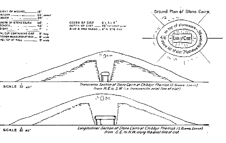
Only a set of diagrams can clearly show the form and type of the Chibbyr Pherrick mound.
(i) It proved to be a stone cairn, which eventually had become covered with earth, When secondary burials were made on the mound perhaps earth was brought and added to the mound around these successive burials': but to begin with, there was at least some earth heaped on the stone cairn, at the least to cover the cist in its cup-like interior.
(ii) The cairn was definitely and intentionally built in an oval form: for it is a hollow cup, of oval form, nine feet long and six feet wide-interior measure at the rim -with rim (that is, with the top of the stone work) a yard wide.
(iii) From this rim level the stonework slopes steeply inwards, that is to say, slopes sharply downwards to the foot of the Gist within it; and slopes very gradually outwards to the skirt of the mound.
(iv.) The cist on the original ground level has, as interior measures, 53 inches of length and 23 inches of breadth the medial line from end to end lying N.W. and S.E.
(v) The capstone, quite overmeasuring the cist all round, measured 6 feet long by 3 feet wide, and g inches thick: being relatively much more massive than the. slabs set on edge to form the sides and ends of the cisb: These latter in no part exceeded 4 inches in thickness, and generally were of thickness from 2 inches to 2½ inches.
(vi) The cist was only three parts full; its depth about 20 inches. It contained earth, mixed throughout with calcined bones in very small fragments. The earth may have been infiltrated; that, in the course of centuries, silted or distributing throughout its increasing mass the calcined bones: at least, the fine character of the mould might justify some such conclusion. Otherwise the earth and bones have been deliberately mixed together, perhaps collected together, bones and earth swept up and put into the cist at its original time of construction.
(vii) The building of the cairn of stones seems to have been begun after the cist was in place, and built up around it, with a batter outwards as the wall rose, from a base 6 feet long by 3 feet wide; and so, as the wall rose, taking an oval form till it reached a height of 6 or 7 feet above the field, showing an oval of 9 feet by 6 feet, and the rim or top of the stone work about 3 feet wide, outside of which the cairn tailed outwards to the skirt of the cairn, the length probably 45 feet and the breadth 42 feet, not counting the earth afterwards accumulated on the cairn, extending its skirt two or three yards farther outwards.
(viii) The hollow (stone) oval must have been filled with clay. It was packed particularly hard and close, and gave much trouble to excavate it out. The earth over the cairn generally and on the top of it, where we found the secondary burials and fragments of very badly made urns, was very much less stiff than the clay immediately over the cist.
The tumulus stands on the corner of Grawe treen, separated from the treen of Swarthow (or Swart Howe-Black Hill) by a water-course and the little ghyll descending to Glenroy river
The mound--already mentioned as destroyed 80 years ago 300 yards north-west of the Grawe tumulus, stands on a holding called ' Cronk Athona,' and ' Thaloo-Vullagh.' There is a Cronk Athena in Kirk Andreas with tumulus and farm names, ' Ball-Athena ' and ' Balla-Wanton.' From this ' Athena ' seems a corruption of ' Atona,' Thallo Vullaghtellus tumuli: the Celtic ' thalloo ' (land), from the same source as , tellus '; and Vullagh from Mullagh, or ta'mulagh,' which, in the parish of German, occurs in the form ' The Mullaghs," viz., the tops landward of Lhergydhoo, where there are identifiable the five tumuli, marked on O.S. map, and another which the Surveyors discarded because cut into two parts by a vast sod fence.
Also, the stone cairn opened last year, go chains N.W. of the Chibbyr Pherrick tumulus, at 900 feet altitude, is on the margin of the Ardwillagh, or Ard-mullagh, possibly ' the Height of the tumulus.'
At Chibbyr Pherrick there was no trace of any flint, whether in flakes or in nodules; and no find of any description other than those mentioned above. Attached are diagrams to scale, showing. the mound, tumulus, etc., for those who desire an accurate idea of the cairn. It will be recognised, of course, as of a type familiar in Sutherlandshire and Caithness, the well-known ' Clova ' Cairn being of this type.
|
|
||

|
|
|
|
|
||
| Any comments, errors or omissions gratefully received MNB
Editor HTML Transcription © F.Coakley , 2008 |
||